What is geostationary satellite
•Als PPTX, PDF herunterladen•
3 gefällt mir•4,968 views

study about geostationary satellite

Empfohlen
Weitere ähnliche Inhalte
Was ist angesagt?
Was ist angesagt? (20)
Ähnlich wie What is geostationary satellite
Ähnlich wie What is geostationary satellite (20)
Kürzlich hochgeladen
Kürzlich hochgeladen (20)
What is geostationary satellite
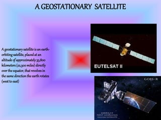
- 1. A GEOSTATIONARY SATELLITE A geostationarysatelliteisanearth- orbitingsatellite, placedat an altitudeof approximately35,800 kilometers(22,300miles)directly overtheequator, thatrevolvesin thesamedirectiontheearthrotates (westto east)
- 2. Geospatial technologY Geospatial technologies is a term used to describe the range of modern tools contributing to the geographic mapping and analysis of the Earth and human societies. These technologies have been evolving in some form since the first maps were drawn in prehistoric times.
- 3. USE OF GEOSTATIONARY SATELLITE Fora geo-stationarysatellite,we all knowthatthepurposesarefor communication, coordination, TV broadcastingandearthobservation.In sun-synchronoussatellitecasethe purposearemostlyforthemilitaryand remotesensing.Thiskindof satellitewe canuseit forspyingothercountries.
- 4. A GEOSTATIONARY ORBIT A geostationaryorbit(GEO)isa circular geosynchronousorbitintheplaneof the Earth'sequatorwitha radiusof approximately42,164km(26,199mi) (measuredfromthecenterof the Earth). A satelliteinsuchanorbitis at an altitudeof approximately35,786km (22,236mi)abovemeansealevel
- 5. ORBIT ALLOCATION Satellites in geostationary orbit must all occupy a single ring above the Equator. The requirement to space these satellites apart to avoid harmful radio-frequency interference during operations means that there are a limited number of orbital "slots" available, thus only a limited number of satellites can be operated in geostationary orbit. This has led to conflict between different countries wishing access to the same orbital slots (countries near the same longitude but differing latitudes) and radio frequencies. These disputes are addressed through the International Telecommunication Union's allocation mechanism.[10][11] In the 1976 Bogotá Declaration, eight countries located on the Earth's equator claimed sovereignty over the geostationary orbits above their territory, but the claims gained no international recognition
- 6. DESIGN OF GEOSTSTIONARY SATELLITE Mostof these birdsare communicationssatellitesof one descriptionor another.A common earlydesign is that of a spin stabilizedcylinder.The HughesHS376 seriesare typical: the main bodybeing some 3 meterslong and 2 metersin diameter.This grows to around6 metersin length once on orbitwiththe extension of the communicationsantennae and an extra skirtof solar panels.These supplement the cellswhichalreadycover the mainbody,making a verynice specular reflector.Thisskirtand the main bodyrotateaboutthe long axis,typicallyat around55 r.p.m.,whilst the antennaand equipment shelf are despun so as to maintain contact with their groundtarget
- 7. VARIOUS TYPES OF GEOSPATIAL TECHNOLOGY Remote Sensing:imagery and data collected from space- or airborne camera and sensor platforms. Some commercial satellite image providers now offer images showing details of one-meter or smaller, making these images appropriate for monitoring humanitarian needs and human rights abuses. GeographicInformationSystems(GIS):a suite of software tools for mapping and analyzing data which is geo referenced (assigned a specific location on the surface of the Earth, otherwise known as geospatial data). GIS can be used to detect geographic patterns in other data, such as disease clusters resulting from toxins, sub-optimal water access, etc. GlobalPositioningSystem(GPS):a network of U.S. Department of Defense satellites which can give precise coordinate locations to civilian and military users with proper receiving equipment (note: a similar European system called Galileo will be operational within the next several years while a Russian system is functioning but restricted). InternetMappingTechnologies:software programs like Google Earth and web features like Microsoft Virtual Earth are changing the way geospatial data is viewed and shared. The developments in user interface are also making such technologies available to a wider audience whereas traditional GIS has been reserved for specialists and those who invest time in learning complex software programs
- 8. Satellite Launch Date Launch Vehicle Remarks ISRO Link Aryabhata 19 April 1975 u-11 Interkosmos Active technological experience in building and operating a satellite system. [1] Bhaskara-I 7 June 1979 C-1 Interkosmos First experimental remote sensing satellite. Carried TV and microwave cameras. [2] Rohini Technology Payload 10 August 1979 SLV-3 Intended for measuring in-flight performance of first experimental flight of SLV-3, the first Indian launch vehicle. Did not achieve orbit. [3] Rohini RS-1 18 July 1980 SLV-3 Used for measuring in- flight performance of second experimental launch of SLV-3. [4] SOME INDIAN GEOSTATIONARY SATELLITES
- 10. MADE BY : DANISH MADAAN XI – CD THANK YOU