
Empfohlen
Weitere ähnliche Inhalte
Mehr von DB3igs
Mehr von DB3igs (20)
Kürzlich hochgeladen
Kürzlich hochgeladen (20)
Waterfall assessment
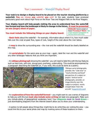
- 1. Year 7 assessment – Waterfall Display Board Your task is to design a display board to be placed on the tourist viewing platform by a waterfall. You can choose any waterfall you wish! In the past, students have produced particularly good work about High Force on the River Tees and Niagara Falls on the River Niagara. Your display board will help people visiting the area to understand how the waterfall has formed and how the landscape is likely to change in the future. It must be presented on one (large!) sheet of paper. You must include the following things on your display board: - Basic facts about the waterfall – for example, information about where it is, how much water falls over the crest at peak flow, types of rock, height of the crest above the river below. - A map to show the surrounding area – the river and the waterfall should be clearly labelled on this map. - An aerial photo for the same area as your map – again, label the river and the waterfall and any other landscape features that you think are important. - An oblique photograph showing the waterfall– you will need to label this with the key features such as hard rock, soft rock, plunge pool, overhang, undercutting. This could be accompanied by a paragraph describing the waterfall (or, if you wish, this could be done as a poem). ‘Oblique aerial photography provides the “side view” or “nearly directly overhead” perspective of a subject or project. Vertical aerial photography provides an image directly over the subject or project; nearly straight down from the aircraft.’ (experts123.com) - An explanation of how the waterfall formed – you might want to use a series of diagrams to help you with this but must also include some writing (at least one paragraph). Make sure you include plenty of geographical vocabulary here! Your diagrams must be hand drawn – just downloading diagrams from the internet doesn’t allow you to show your understanding. - A section to tell people about things they might like to do while they are visiting the area – you could link this to your aerial photo and map by marking some of these locations on them. DEADLINE:Handinat start of lessonThursday2nd March.Take a highresolutionphotograph as backup beforesubmitting
- 2. Optional Extension: A description of how you would expect the waterfall to change in the future and an explanation of why you would expect this to happen. This is also a good place to show off how much geographical vocabulary you can use. You might include old maps and photos here to show how the waterfall has already changed over time.