SlideShare ist ein Scribd-Unternehmen logo
1 von 1
Downloaden Sie, um offline zu lesen
CONTINENTAL MAPPING
www.continentalmapping.com
888.815.3327
PROJECT PROFILE: USACE Tulsa District
Boundary Survey
THE STORY:
After the Civil War, American military focus shifted to the immense task of
settling the west. In early 1869, Major General Phil Sheridan staked out a
patch of land deep in Indian Territory that would become Fort Sill. At the time,
Oklahoma was virtually off limits to settlement and would not become a state
for another 38 years. Fast forward almost 150 years, and the Army’s Fort Sill
is stronger than ever at a sprawling 323,760 square miles. Fort Sill is consid-
ered one of the premier training facilities in the military, tasked with training
the best artillery soldiers in the world.
Fort Sill has grown regularly through the years, but formal tracking of the
fort’s real estate holdings had not kept pace. Prior to the project, the most
recent boundary survey was performed by the Army in 1936. This meant that
in 2014, approximately 25% of the fort’s boundary was missing from the
official record. Additionally, a roadway realignment completed several
decades prior had never been surveyed. That roadway, as seen above, cuts
right through the fort and the adjacent Wichita Mountains Wildlife Refuge.
On top of that, encroachments and inferior security fencing in remote
sections of the base dictated the need for boundary survey.
Continental Mapping was tasked by the US Army Corps of Engineers to
perform 75 miles of boundary surveying at Fort Sill. Work has included site
investigation, land records research, coordination with local, state and
federal agencies, establishing monuments and signs at every corner,
and delivering a final survey for recordation at the county courthouse.
The survey research proved to be a significant task involving many historical documents,
some dating back to the late 1800s, describing the history of Fort Sill’s boundary. At that time,
the boundary was marked by four stones at each corner of the property. Continental Mapping
is using all available sources to accurately retrace the boundary including resurvey
information from the Bureau of Land Management and US Army as well as local
surveys.
LOCATION: Oklahoma
YEAR COMPLETED: 2015
OBJECTIVE: Re-establish government property lines
KEY POINTS:
• 75 miles of boundary to re-establish
• Conflation of numerous historical records
• Performed simultaneously with other site work
• Active military training facility
C
lea
r Boggy
C
reekMuddyBoggyCr
eek
R
ed
River
Kiamichi River
Little River
Mntn. Fk.
PoteauRiv
e
r
W
ashitaRive
BeaverCreek
R ed Ri ver
North Wichita River
e Pease River
N
orth Pease River
Red River
ver
rth Fork Of Red River
anadian River
Washita River
W olf Creek
North Can
adia
n
River
North
Canadian
River
CanadianR
iver
Cimarron
River
Deep Fork Of The Canad ian
River
Illinois
Riv
er
A rkansas Ri
ver
Sand
Creek
Cro
oked Cree
k Bluf
fCreek
M
ule Cre
ek
Salt Fork Of
Arkansas River
Ni
nnescah R.
Slate
C
r.
E
lk Rive
r
Fa
ll
R
iver
LittleCane
y
CaneyRiver
WalnutRiver
ArkansasRiver
BirdC
reek
Hominy
Cr.
Webbers
Falls
Port of
Catoosa
Newt
Graham
Chouteau
W.D. Mayo
Wichita River
Arkansas River
LakeKemp
TomSteed
Altus
Fort Cobb
Thunderbird
Foss
Cheney
LakeHudson
Grand
Lake
McGeeCreek
Arbuckle
Broken
Bow
Pine
Creek
Hugo
Sardis
Pat Mayse
Lake
Texoma
Truscott
Waurika
Arcadia
Heyburn
Eufaula
Wister
Robert
S.Kerr
Tenkiller
Ferry
Fort
Gibson
Keystone
Skiatook
Oologah
Copan
ElkCity
Toronto
El Dorado
Fall River
Pearson-Skubitz
Big Hill Lake
Hulah
Birch
Fort Supply
Canton
Great Salt Plains
Kaw
3
3
3
19
19
51
51
33
43
412
400 169
169
400
412
183
183
412
69
69
75
75
83
75
77
54
64
75
70
70 70
82
271
177
177
259
271
59
44
44
35
35
35
40
40
40
44
44
Pratt
Fredonia
Independence
Jet
Coffeyville
Bartlesville
PoncaCity
Stillwater
Shawnee
OKLAHOMA
CITY
Enid
Norman
Lawton Duncan
ElkCity
Woodward
Ardmore
Wichita
Falls
TULSA
Broken
Arrow
Muskogee
Claremore
Tahlequah
Sallisaw
Fort
Smith
Okmulgee
Henryetta
McAlester
Durant
Idabel
Denison
Sherman
Ada
Joplin
WICHITA
KANSAS
OKLAHOMA
ARKANSAS
OKLAHOMA
TEXAS
OKLAHOMA
MISSOURI
KANSAS
Keystone
Webbers Falls
Tenkiller
Eufaula
Robert S. Kerr
Ft. Gibson
Broken Bow
Denison
Altus AFB
Fort Sill
Sheppard
AFB
Tinker
AFB
Vance
AFB
McAlester
AAP

Weitere ähnliche Inhalte

Andere mochten auch

Continental Mapping Projects - Tualatin National Wildlife Refuge
Continental Mapping Projects - Tualatin National Wildlife RefugeContinental Mapping Projects - Tualatin National Wildlife Refuge
Continental Mapping Projects - Tualatin National Wildlife RefugeContinental Mapping Consultants
 
Tijdschrift voor Verloskundigen - Ingrijpende gebeurtenissen op de werkvloer ...
Tijdschrift voor Verloskundigen - Ingrijpende gebeurtenissen op de werkvloer ...Tijdschrift voor Verloskundigen - Ingrijpende gebeurtenissen op de werkvloer ...
Tijdschrift voor Verloskundigen - Ingrijpende gebeurtenissen op de werkvloer ...Claire Stramrood
 
Temario ii exámen, i trimestre 9º,2016
Temario ii exámen, i trimestre 9º,2016Temario ii exámen, i trimestre 9º,2016
Temario ii exámen, i trimestre 9º,2016Prof.Grettel _mate
 
The Convergence of the BuySide and SellSide
The Convergence of the BuySide and SellSideThe Convergence of the BuySide and SellSide
The Convergence of the BuySide and SellSideShihab Khalil
 
Esperimenti di estrazione e correlazione di concetti bis
Esperimenti di estrazione e correlazione di concetti bisEsperimenti di estrazione e correlazione di concetti bis
Esperimenti di estrazione e correlazione di concetti bisRiccardo Grosso
 
Intercollegiale opvang na ingrijpende gebeurtenissen - APOG 2016
Intercollegiale opvang na ingrijpende gebeurtenissen - APOG 2016Intercollegiale opvang na ingrijpende gebeurtenissen - APOG 2016
Intercollegiale opvang na ingrijpende gebeurtenissen - APOG 2016Claire Stramrood
 

Andere mochten auch (13)

Continental mapping projects indot south split
Continental mapping projects   indot south splitContinental mapping projects   indot south split
Continental mapping projects indot south split
 
Continental Mapping Projects - Tualatin National Wildlife Refuge
Continental Mapping Projects - Tualatin National Wildlife RefugeContinental Mapping Projects - Tualatin National Wildlife Refuge
Continental Mapping Projects - Tualatin National Wildlife Refuge
 
Map America - 10 Tallest Dams Infographic
Map America - 10 Tallest Dams InfographicMap America - 10 Tallest Dams Infographic
Map America - 10 Tallest Dams Infographic
 
Control for Mobile Lidar
Control for Mobile LidarControl for Mobile Lidar
Control for Mobile Lidar
 
Storygraphic - The Continental Mapping Story
Storygraphic - The Continental Mapping StoryStorygraphic - The Continental Mapping Story
Storygraphic - The Continental Mapping Story
 
Tijdschrift voor Verloskundigen - Ingrijpende gebeurtenissen op de werkvloer ...
Tijdschrift voor Verloskundigen - Ingrijpende gebeurtenissen op de werkvloer ...Tijdschrift voor Verloskundigen - Ingrijpende gebeurtenissen op de werkvloer ...
Tijdschrift voor Verloskundigen - Ingrijpende gebeurtenissen op de werkvloer ...
 
التدوين
التدوينالتدوين
التدوين
 
Temario ii exámen, i trimestre 9º,2016
Temario ii exámen, i trimestre 9º,2016Temario ii exámen, i trimestre 9º,2016
Temario ii exámen, i trimestre 9º,2016
 
The Convergence of the BuySide and SellSide
The Convergence of the BuySide and SellSideThe Convergence of the BuySide and SellSide
The Convergence of the BuySide and SellSide
 
Capacitacao Consultorio Online
Capacitacao Consultorio OnlineCapacitacao Consultorio Online
Capacitacao Consultorio Online
 
Esperimenti di estrazione e correlazione di concetti bis
Esperimenti di estrazione e correlazione di concetti bisEsperimenti di estrazione e correlazione di concetti bis
Esperimenti di estrazione e correlazione di concetti bis
 
Intercollegiale opvang na ingrijpende gebeurtenissen - APOG 2016
Intercollegiale opvang na ingrijpende gebeurtenissen - APOG 2016Intercollegiale opvang na ingrijpende gebeurtenissen - APOG 2016
Intercollegiale opvang na ingrijpende gebeurtenissen - APOG 2016
 
1PROFILE
1PROFILE1PROFILE
1PROFILE
 

Mehr von Continental Mapping Consultants (13)

Continental Mapping Introduces TheGeoFoundry.com
Continental Mapping Introduces TheGeoFoundry.comContinental Mapping Introduces TheGeoFoundry.com
Continental Mapping Introduces TheGeoFoundry.com
 
Continental Mapping Projects - Wood Road Re-alignment
Continental Mapping Projects - Wood Road Re-alignmentContinental Mapping Projects - Wood Road Re-alignment
Continental Mapping Projects - Wood Road Re-alignment
 
Transportation Mapping
Transportation MappingTransportation Mapping
Transportation Mapping
 
Continental Mapping - On All Continents
Continental Mapping - On All Continents Continental Mapping - On All Continents
Continental Mapping - On All Continents
 
FAA UAS Map
FAA UAS MapFAA UAS Map
FAA UAS Map
 
Red Wing Bridge Project
Red Wing Bridge ProjectRed Wing Bridge Project
Red Wing Bridge Project
 
Aztalan Project
Aztalan ProjectAztalan Project
Aztalan Project
 
Continental Mapping Projects - Dodger Stadium
Continental Mapping Projects - Dodger StadiumContinental Mapping Projects - Dodger Stadium
Continental Mapping Projects - Dodger Stadium
 
Continental Mapping Projects - Trans Design
Continental Mapping Projects - Trans DesignContinental Mapping Projects - Trans Design
Continental Mapping Projects - Trans Design
 
Mobile Lidar - Speed You Need
Mobile Lidar - Speed You NeedMobile Lidar - Speed You Need
Mobile Lidar - Speed You Need
 
Yukon Delta Refuge Infographic
Yukon Delta Refuge InfographicYukon Delta Refuge Infographic
Yukon Delta Refuge Infographic
 
Photogrammetry
PhotogrammetryPhotogrammetry
Photogrammetry
 
Data Fusion Menu
Data Fusion MenuData Fusion Menu
Data Fusion Menu
 

Kürzlich hochgeladen

Correctly Loading Incremental Data at Scale
Correctly Loading Incremental Data at ScaleCorrectly Loading Incremental Data at Scale
Correctly Loading Incremental Data at ScaleAlluxio, Inc.
 
Research Methodology for Engineering pdf
Research Methodology for Engineering pdfResearch Methodology for Engineering pdf
Research Methodology for Engineering pdfCaalaaAbdulkerim
 
"Exploring the Essential Functions and Design Considerations of Spillways in ...
"Exploring the Essential Functions and Design Considerations of Spillways in ..."Exploring the Essential Functions and Design Considerations of Spillways in ...
"Exploring the Essential Functions and Design Considerations of Spillways in ...Erbil Polytechnic University
 
System Simulation and Modelling with types and Event Scheduling
System Simulation and Modelling with types and Event SchedulingSystem Simulation and Modelling with types and Event Scheduling
System Simulation and Modelling with types and Event SchedulingBootNeck1
 
Katarzyna Lipka-Sidor - BIM School Course
Katarzyna Lipka-Sidor - BIM School CourseKatarzyna Lipka-Sidor - BIM School Course
Katarzyna Lipka-Sidor - BIM School Coursebim.edu.pl
 
Virtual memory management in Operating System
Virtual memory management in Operating SystemVirtual memory management in Operating System
Virtual memory management in Operating SystemRashmi Bhat
 
complete construction, environmental and economics information of biomass com...
complete construction, environmental and economics information of biomass com...complete construction, environmental and economics information of biomass com...
complete construction, environmental and economics information of biomass com...asadnawaz62
 
THE SENDAI FRAMEWORK FOR DISASTER RISK REDUCTION
THE SENDAI FRAMEWORK FOR DISASTER RISK REDUCTIONTHE SENDAI FRAMEWORK FOR DISASTER RISK REDUCTION
THE SENDAI FRAMEWORK FOR DISASTER RISK REDUCTIONjhunlian
 
Risk Management in Engineering Construction Project
Risk Management in Engineering Construction ProjectRisk Management in Engineering Construction Project
Risk Management in Engineering Construction ProjectErbil Polytechnic University
 
Arduino_CSE ece ppt for working and principal of arduino.ppt
Arduino_CSE ece ppt for working and principal of arduino.pptArduino_CSE ece ppt for working and principal of arduino.ppt
Arduino_CSE ece ppt for working and principal of arduino.pptSAURABHKUMAR892774
 
11. Properties of Liquid Fuels in Energy Engineering.pdf
11. Properties of Liquid Fuels in Energy Engineering.pdf11. Properties of Liquid Fuels in Energy Engineering.pdf
11. Properties of Liquid Fuels in Energy Engineering.pdfHafizMudaserAhmad
 
Industrial Safety Unit-IV workplace health and safety.ppt
Industrial Safety Unit-IV workplace health and safety.pptIndustrial Safety Unit-IV workplace health and safety.ppt
Industrial Safety Unit-IV workplace health and safety.pptNarmatha D
 
Sachpazis Costas: Geotechnical Engineering: A student's Perspective Introduction
Sachpazis Costas: Geotechnical Engineering: A student's Perspective IntroductionSachpazis Costas: Geotechnical Engineering: A student's Perspective Introduction
Sachpazis Costas: Geotechnical Engineering: A student's Perspective IntroductionDr.Costas Sachpazis
 
Gurgaon ✡️9711147426✨Call In girls Gurgaon Sector 51 escort service
Gurgaon ✡️9711147426✨Call In girls Gurgaon Sector 51 escort serviceGurgaon ✡️9711147426✨Call In girls Gurgaon Sector 51 escort service
Gurgaon ✡️9711147426✨Call In girls Gurgaon Sector 51 escort servicejennyeacort
 
Class 1 | NFPA 72 | Overview Fire Alarm System
Class 1 | NFPA 72 | Overview Fire Alarm SystemClass 1 | NFPA 72 | Overview Fire Alarm System
Class 1 | NFPA 72 | Overview Fire Alarm Systemirfanmechengr
 
Work Experience-Dalton Park.pptxfvvvvvvv
Work Experience-Dalton Park.pptxfvvvvvvvWork Experience-Dalton Park.pptxfvvvvvvv
Work Experience-Dalton Park.pptxfvvvvvvvLewisJB
 
National Level Hackathon Participation Certificate.pdf
National Level Hackathon Participation Certificate.pdfNational Level Hackathon Participation Certificate.pdf
National Level Hackathon Participation Certificate.pdfRajuKanojiya4
 
Engineering Drawing section of solid
Engineering Drawing     section of solidEngineering Drawing     section of solid
Engineering Drawing section of solidnamansinghjarodiya
 
IVE Industry Focused Event - Defence Sector 2024
IVE Industry Focused Event - Defence Sector 2024IVE Industry Focused Event - Defence Sector 2024
IVE Industry Focused Event - Defence Sector 2024Mark Billinghurst
 

Kürzlich hochgeladen (20)

Correctly Loading Incremental Data at Scale
Correctly Loading Incremental Data at ScaleCorrectly Loading Incremental Data at Scale
Correctly Loading Incremental Data at Scale
 
Research Methodology for Engineering pdf
Research Methodology for Engineering pdfResearch Methodology for Engineering pdf
Research Methodology for Engineering pdf
 
"Exploring the Essential Functions and Design Considerations of Spillways in ...
"Exploring the Essential Functions and Design Considerations of Spillways in ..."Exploring the Essential Functions and Design Considerations of Spillways in ...
"Exploring the Essential Functions and Design Considerations of Spillways in ...
 
System Simulation and Modelling with types and Event Scheduling
System Simulation and Modelling with types and Event SchedulingSystem Simulation and Modelling with types and Event Scheduling
System Simulation and Modelling with types and Event Scheduling
 
Katarzyna Lipka-Sidor - BIM School Course
Katarzyna Lipka-Sidor - BIM School CourseKatarzyna Lipka-Sidor - BIM School Course
Katarzyna Lipka-Sidor - BIM School Course
 
Designing pile caps according to ACI 318-19.pptx
Designing pile caps according to ACI 318-19.pptxDesigning pile caps according to ACI 318-19.pptx
Designing pile caps according to ACI 318-19.pptx
 
Virtual memory management in Operating System
Virtual memory management in Operating SystemVirtual memory management in Operating System
Virtual memory management in Operating System
 
complete construction, environmental and economics information of biomass com...
complete construction, environmental and economics information of biomass com...complete construction, environmental and economics information of biomass com...
complete construction, environmental and economics information of biomass com...
 
THE SENDAI FRAMEWORK FOR DISASTER RISK REDUCTION
THE SENDAI FRAMEWORK FOR DISASTER RISK REDUCTIONTHE SENDAI FRAMEWORK FOR DISASTER RISK REDUCTION
THE SENDAI FRAMEWORK FOR DISASTER RISK REDUCTION
 
Risk Management in Engineering Construction Project
Risk Management in Engineering Construction ProjectRisk Management in Engineering Construction Project
Risk Management in Engineering Construction Project
 
Arduino_CSE ece ppt for working and principal of arduino.ppt
Arduino_CSE ece ppt for working and principal of arduino.pptArduino_CSE ece ppt for working and principal of arduino.ppt
Arduino_CSE ece ppt for working and principal of arduino.ppt
 
11. Properties of Liquid Fuels in Energy Engineering.pdf
11. Properties of Liquid Fuels in Energy Engineering.pdf11. Properties of Liquid Fuels in Energy Engineering.pdf
11. Properties of Liquid Fuels in Energy Engineering.pdf
 
Industrial Safety Unit-IV workplace health and safety.ppt
Industrial Safety Unit-IV workplace health and safety.pptIndustrial Safety Unit-IV workplace health and safety.ppt
Industrial Safety Unit-IV workplace health and safety.ppt
 
Sachpazis Costas: Geotechnical Engineering: A student's Perspective Introduction
Sachpazis Costas: Geotechnical Engineering: A student's Perspective IntroductionSachpazis Costas: Geotechnical Engineering: A student's Perspective Introduction
Sachpazis Costas: Geotechnical Engineering: A student's Perspective Introduction
 
Gurgaon ✡️9711147426✨Call In girls Gurgaon Sector 51 escort service
Gurgaon ✡️9711147426✨Call In girls Gurgaon Sector 51 escort serviceGurgaon ✡️9711147426✨Call In girls Gurgaon Sector 51 escort service
Gurgaon ✡️9711147426✨Call In girls Gurgaon Sector 51 escort service
 
Class 1 | NFPA 72 | Overview Fire Alarm System
Class 1 | NFPA 72 | Overview Fire Alarm SystemClass 1 | NFPA 72 | Overview Fire Alarm System
Class 1 | NFPA 72 | Overview Fire Alarm System
 
Work Experience-Dalton Park.pptxfvvvvvvv
Work Experience-Dalton Park.pptxfvvvvvvvWork Experience-Dalton Park.pptxfvvvvvvv
Work Experience-Dalton Park.pptxfvvvvvvv
 
National Level Hackathon Participation Certificate.pdf
National Level Hackathon Participation Certificate.pdfNational Level Hackathon Participation Certificate.pdf
National Level Hackathon Participation Certificate.pdf
 
Engineering Drawing section of solid
Engineering Drawing     section of solidEngineering Drawing     section of solid
Engineering Drawing section of solid
 
IVE Industry Focused Event - Defence Sector 2024
IVE Industry Focused Event - Defence Sector 2024IVE Industry Focused Event - Defence Sector 2024
IVE Industry Focused Event - Defence Sector 2024
 

Fort Sill Boundary Survey USACE Tulsa District

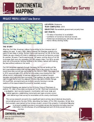
  • 1. CONTINENTAL MAPPING www.continentalmapping.com 888.815.3327 PROJECT PROFILE: USACE Tulsa District Boundary Survey THE STORY: After the Civil War, American military focus shifted to the immense task of settling the west. In early 1869, Major General Phil Sheridan staked out a patch of land deep in Indian Territory that would become Fort Sill. At the time, Oklahoma was virtually off limits to settlement and would not become a state for another 38 years. Fast forward almost 150 years, and the Army’s Fort Sill is stronger than ever at a sprawling 323,760 square miles. Fort Sill is consid- ered one of the premier training facilities in the military, tasked with training the best artillery soldiers in the world. Fort Sill has grown regularly through the years, but formal tracking of the fort’s real estate holdings had not kept pace. Prior to the project, the most recent boundary survey was performed by the Army in 1936. This meant that in 2014, approximately 25% of the fort’s boundary was missing from the official record. Additionally, a roadway realignment completed several decades prior had never been surveyed. That roadway, as seen above, cuts right through the fort and the adjacent Wichita Mountains Wildlife Refuge. On top of that, encroachments and inferior security fencing in remote sections of the base dictated the need for boundary survey. Continental Mapping was tasked by the US Army Corps of Engineers to perform 75 miles of boundary surveying at Fort Sill. Work has included site investigation, land records research, coordination with local, state and federal agencies, establishing monuments and signs at every corner, and delivering a final survey for recordation at the county courthouse. The survey research proved to be a significant task involving many historical documents, some dating back to the late 1800s, describing the history of Fort Sill’s boundary. At that time, the boundary was marked by four stones at each corner of the property. Continental Mapping is using all available sources to accurately retrace the boundary including resurvey information from the Bureau of Land Management and US Army as well as local surveys. LOCATION: Oklahoma YEAR COMPLETED: 2015 OBJECTIVE: Re-establish government property lines KEY POINTS: • 75 miles of boundary to re-establish • Conflation of numerous historical records • Performed simultaneously with other site work • Active military training facility C lea r Boggy C reekMuddyBoggyCr eek R ed River Kiamichi River Little River Mntn. Fk. PoteauRiv e r W ashitaRive BeaverCreek R ed Ri ver North Wichita River e Pease River N orth Pease River Red River ver rth Fork Of Red River anadian River Washita River W olf Creek North Can adia n River North Canadian River CanadianR iver Cimarron River Deep Fork Of The Canad ian River Illinois Riv er A rkansas Ri ver Sand Creek Cro oked Cree k Bluf fCreek M ule Cre ek Salt Fork Of Arkansas River Ni nnescah R. Slate C r. E lk Rive r Fa ll R iver LittleCane y CaneyRiver WalnutRiver ArkansasRiver BirdC reek Hominy Cr. Webbers Falls Port of Catoosa Newt Graham Chouteau W.D. Mayo Wichita River Arkansas River LakeKemp TomSteed Altus Fort Cobb Thunderbird Foss Cheney LakeHudson Grand Lake McGeeCreek Arbuckle Broken Bow Pine Creek Hugo Sardis Pat Mayse Lake Texoma Truscott Waurika Arcadia Heyburn Eufaula Wister Robert S.Kerr Tenkiller Ferry Fort Gibson Keystone Skiatook Oologah Copan ElkCity Toronto El Dorado Fall River Pearson-Skubitz Big Hill Lake Hulah Birch Fort Supply Canton Great Salt Plains Kaw 3 3 3 19 19 51 51 33 43 412 400 169 169 400 412 183 183 412 69 69 75 75 83 75 77 54 64 75 70 70 70 82 271 177 177 259 271 59 44 44 35 35 35 40 40 40 44 44 Pratt Fredonia Independence Jet Coffeyville Bartlesville PoncaCity Stillwater Shawnee OKLAHOMA CITY Enid Norman Lawton Duncan ElkCity Woodward Ardmore Wichita Falls TULSA Broken Arrow Muskogee Claremore Tahlequah Sallisaw Fort Smith Okmulgee Henryetta McAlester Durant Idabel Denison Sherman Ada Joplin WICHITA KANSAS OKLAHOMA ARKANSAS OKLAHOMA TEXAS OKLAHOMA MISSOURI KANSAS Keystone Webbers Falls Tenkiller Eufaula Robert S. Kerr Ft. Gibson Broken Bow Denison Altus AFB Fort Sill Sheppard AFB Tinker AFB Vance AFB McAlester AAP