SlideShare a Scribd company logo
1 of 101
Download to read offline
Construction of Satellite Ground Station
Page1
Certificate
A project report on the topic of “Construction of Satellite Ground Station” was carried out by
undersigned students of BS (Hons., Session: 2009-2013) under the supervision of Sir Zia-ul-
Haq, Assistant Professor, and same are hereby submitted to the Department of Space Science,
University of the Punjab in partial fulfillment of the requirements for the award of the BS
(Hons.) degree in Space Science.
Dated:
Supervisor Chairman
Zia-ul-Haq Dr. Muhammad Ali
Assistant Professor Department of Space Science
Department of Space Science University of the Punjab, Lahore
University of the Punjab, Lahore
Serial No Names Roll no. Signature
01. Atiqa Ijaz Khan ss09-03
02. Syeda Rbiya Mehmood ss09-14
03. Usama Maqsood ss09-25
04. Faiza Shoukat ss09-26
05. Pervaiz Elahi ss09-27
Construction of Satellite Ground Station
Page2
Dedication
This project report is dedicated to our respected teachers and parents who made us to see the
height of this achievement.
Construction of Satellite Ground Station
Page3
Acknowledgement
All praises, to ALLAH Almighty, the most Merciful and Beneficial. And all the Blessings
from Almighty on us Who is the everlasting source of knowledge and wisdom.
Foremost we would like to pay our sincere gratitude to our Supervisor, Sir Zia-ul-Haq, for his
continuous support and assistance for our project study and report.
We are very grateful to our Chairman, Dr. Muhammad Ali, for providing us with such an
environment so to complete our project on time successfully.
We are also thankful to our respectable teachers for their immense knowledge throughout the
4-year degree program. So by here we are in a position of submitting our final year project
report.
We would like to Ronnie Nader, 1st Ecuadorian Astronaut / Mission Director at EXA, for his
support and help regarding online tracking using HERMES Project.
Construction of Satellite Ground Station
Page4
Table of Contents
1) Abstract 09
2) Chapter 1: Introduction 11
3) Chapter 2: The Satellite System 14
a. Types of Satellites 14
i. Communication Satellites 15
ii. Earth Observation Satellites 16
iii. Navigation Satellites 17
iv. Military Satellites 17
v. Special Satellites 18
vi. Remote Sensing Satellites 18
vii. Weather Satellites 19
b. Component of Satellites 19
i. Payload 20
ii. Bus 20
c. Weather Satellite System 26
i. Categories of Weather Satellite System 26
ii. Working with Weather Satellites 28
iii. Weather Satellite Imagery System 29
4) Chapter 3: Working with NOAA 34
a. NOAA Satellite Series 34
b. Orbital Properties 37
c. Modes of Operation 38
d. NOAA Frequencies 38
e. Modulation Techniques 39
5) Chapter 4: Weather Satellite Receiver 41
a. Receiving System of Weather Satellites 41
b. Modes of Reception of Weather Satellites 43
c. Transmission Parameters for POES Satellite System 45
6) Chapter 5: Automatic Picture Transmission System 48
a. APT Transmission Format 49
b. Requirements for Building an APT System 50
7) Chapter 6: Construction of Antenna 56
Construction of Satellite Ground Station
Page5
a. Omni-directional Antennas 56
b. Directional Antennas 57
c. Cross Antennas 58
d. Double Cross Antennas 58
e. Why we choose Double Cross Dipole Antenna? 60
f. Construction 61
i. Calculation of Dipole Rod Length 63
8) Chapter 7: Introduction to Wpeix 2000 B Receiver 65
a. Calibration 65
b. Selection Criteria for Receiver 66
9) Chapter 8: Introduction to WXtoImg 69
a. Software Features 69
b. Versions 69
c. Calibration 70
d. Why we choose WXtoImg? 74
e. Sample Images 75
10) Chapter 9: Online Tracking of Satellite Images 77
a. Background 77
b. Project Hermes 78
c. Modes of Operation 79
d. Implementation of Delta Mode 80
e. Future Expansion 82
11) Issues and Problems 84
12) Conclusion 85
13) Recommendation 86
14) Glossary 87
15) Performance 94
16) Software List 96
17) References 97
Construction of Satellite Ground Station
Page6
List of Figures
1. Figure: Satellite 14
2. Figure 01: ANIK 16
3. Figure 02: Quick Bird 16
4. Figure 03: Navstar 17
5. Figure 04: Military Satellite 17
6. Figure 05: Galileo 18
7. Figure 06: Landsat 18
8. Figure 07: Meteosat 19
9. Figure 08: Component of Satellite 20
10. Figure 09: GOES 24
11. Figure 10: POES 27
12. Figure 11: GOES GVAR (United East Cost) 28
13. Figure 12: HRPT (Hurricane Emily) 42
14. Figure 13: APT (Europe) 42
15. Figure 14: WEFAX and HRI (Europe) 43
16. Figure 15: Commercial Pre-amplifier 45
17. Figure 16: APT Transmission Format 46
18. Figure 17: APT Ground Station 49
19. Figure 18: Antenna Requirement 50
20. Figure 19: WeSaCom APT-06 53
21. Figure 20: R2FX 53
22. Figure 21: Hamtronics 54
23. Figure 22: EMGO 54
24. Figure 23: Cross Dipole Antenna 58
25. Figure 24: Double Cross Dipole Antenna 59
26. Figure 25: Double Cross Dipole Antenna 59
27. Figure 26: Pipes of Antenna 61
28. Figure 27: Holders of Antenna 61
29. Figure 28: Pipes Assembly 62
30. Figure 29: Final Antenna 62
31. Figure 30: Dipole Phasing 63
32. Figure 31: Wpeix 2000 B 65
Construction of Satellite Ground Station
Page7
33. Figure 32 Enter Your Location 71
34. Figure 33: Satellite Pass list 71
35. Figure 34: Volume Adjustment 72
36. Figure 35: Slant Correction 73
37. Figure 36: WXtoImg Interface 73
38. Figure 37: A Typical Decoded Image by WXtoImg 75
39. Figure 38: MSA Enhanced Image by WXtoImg 75
40. Figure 39: Sample Image by Project Hermes 77
41. Figure 40: Hermes Working 79
42. Figure 41: Implementation of Project Hermes 80
43. Figure 42: VRS Monitor 81
44. Figure 43: Listen Connection 81
45. Figure 44: Delta Client Side 82
46. Figure 45: Future Expansion 83
47. Figure 46: APT Setup 94
48. Figure 47: Audio Files of WXtoImg 94
49. Figure 48: NOAA 15 Image on WXtoImg 95
Construction of Satellite Ground Station
Page8
List of Tables
1. Table 01: Satellite Categories 15
2. Table 02: Comparison of Satellites 31
3. Table 03: Comparison between Polar and Geostationary Satellites 32
4. Table 04: GOES 35
5. Table 05: NOAA 36, 37
6. Table 06: Orbital Properties of NOAA 37
7. Table 07: Modes of Operation 38
8. Table 08: NOAA Frequencies 38
9. Table 09: NOAA Modulation Techniques 39
10. Table 10: US POES Satellite Parameters 45
11. Table 11: Properties of APT 48, 49
12. Table 12: Comparison between Cross And Double Cross Antenna 60
13. Table 13: Comparison of Double Cross Antenna 60
14. Table 14: Comparison of Wpeix 2000 B 66
15. Table 15: Versions of WXtoImg 69, 70
16. Table 16: Comparison of WXtoImg 74
Construction of Satellite Ground Station
Page9
Abstract
The world has progress to the century of technology where everything is in the click of a
second. Satellite images are one of the key aspects of advancement of this era. There come
many methods to deal with these images for educational, scientific, re-search, and military
purposes. The basic thing to do is to obtain them for a user. In order to provide this facility,
one of the applications is APT that is Automatic Picture Transmission. That is actually a low
resolution image by low orbiting satellites like NOAA.
The main objective of this project report is to establish an APT ground station to meet the
educational purposes of the student of our Department of Space Science, University of the
Punjab. It comes with antenna and decoder. This project report highlights the working and
building of an APT station at a reasonable cost. In future, the room of modification is still
available; it is just a starting towards the higher goals.
Construction of Satellite Ground Station
Page10
Chapter 01
Construction of Satellite Ground Station
Page11
Introduction
In the last few decades, the satellite reception system is more into consideration. The weather
satellite receiving system has evolved with time and come to this stage of advancement. Now
it is affordable for even small institute and department to have their satellite ground station.
That is in return one step forward at the educational level. NOAA is the most easily available
satellite for the weather reception.
The technique used here is of automatic picture transmission (APT). There are two modes of
this operation. Satellite imagery can be accessed by formally building an APT ground station,
using antennas, amplifier, decoders and software. Secondly it can also be tracked by online
systems.
This project report is started from the general information about the satellites and its types.
Weather satellite reception system is the key towards the better understanding of this system,
so this topic is also discussed here. It then mainly focused on the NOAA satellites and its
reception system, as per our need. NOAA polar orbiting satellite system is the foremost
requirement of the APT.
As the APT operate on polar satellites. Building of an APT ground station requires a little
basic work on the antennas. As antennas are building blocks of any reception system. For
signals to receive properly, another important part is pre-amplifier. The strength of the signal
is mostly depended upon the area where the signal is receiving. Other factors are also there.
As a result, the APT catches the signal as satellite passes through our mandatory track. Then
it is further decoded by the help of software, such as WXtoImg. Now the images are ready for
any kind of analysis.
For the satellite images to be captured and displayed, the setup requires a receiver. The
quality of the receiver defines the resolution of the images. This is an important portion of an
APT system. The apparatus used here is Wpeix 2000 B.
There many software available for tracking as well as decoding of the satellite images. It is
up to user demand, which software can display the finest images to meet up the demands of
users. They are all there in internet in free version and paid ones. Obviously, the paid one
carries the greatest features with it, which is a helpful key for experts.
Construction of Satellite Ground Station
Page12
Another approach is here in the favor satellite reception system. Online tracking is available
now days. It gives the real time tracking of the satellite to the remote users. It gives relief to
thousands of users. As it is less than one click distance.
Another option for obtaining the satellite data is to get connected with Project Agora,
Hermes. By this way, the University should have a cooperation contract with EXA. Then
they generate the user name and password. We have to provide them with our public IP
address. After completing all this steps, it is now available for us to get the satellite images on
our pc.
These images can be further used in analysis from a layman to students, teachers, experts,
researchers, scientists, and all other fields. These images are also for military purposes.
Construction of Satellite Ground Station
Page13
Contents
Types of Satellites
Communicational Sat
Earth Observing Sat
Navigation Sat
Military Sat
Special Sat
Remote Sensing Sat
Weather Sat
Component of Satellite
Merits
De-merits
Weather Satellite System
Categories
Working
Satellite Imagery
Chapter 02Chapter 02
Construction of Satellite Ground Station
Page14
The Satellite System
o deal with satellite system, the knowledge of the satellite is essential. Without this, it is
impossible to understand the processes of the satellite systems.
According to Frenzel,
“A satellite is a physical object that orbits a celestial body.”
Some satellites are natural, as the moon which is the natural satellite of earth. Some satellites
are made by scientists to go around the earth. These satellites provide us with valuable
information regarding weather, remote sensing etc. for communication satellites remain fixed
above the surface of earth and provide worldwide information.
Some satellites are for sending and receiving the signals. These signals are sent from a space
station on the surface of earth. These satellites receive the signal and re-broadcast it to other
places on the earth.
Some satellites sent and receive fax, telephone and
computer communication.
Other satellites observe the weather, feeding
weather information into giant computers programs
that help scientists know what the weather will be.
All weather reports on our TV news program are
getting their information from these satellites.
Figure: Satellite
Some satellites take pictures of earth‟s surface, sending back images that tell scientists about
changes that are going on around the world.
Types of Satellites
On the basis of usage, satellites are divided into following categories:
T
Construction of Satellite Ground Station
Page15
1. Communication satellites
2. Earth Observation satellites
3. Navigation satellites
4. Military satellites
5. Special satellites
6. Remote sensing satellites
7. Weather satellites
Table 1: Satellite Categories
Communication Satellites:
Communication satellites are used for audio, video and data transmission. They carry large
dishes to capture radio waves and heavy solar panels for powering the sound amplifiers.
Their orbit is geosynchronous 22300 miles above earth‟s equator.
Examples:
 Sputnik-1
Construction of Satellite Ground Station
Page16
 Nimbus-3
 Westar-1
 Arabsat-1A
 Badar
 TIROS-1
Figure 1: Courtesy: NASA Glenn Research Center (ANIK)
Earth Observation Satellites:
Earth observation satellites are used for photographing the earth to observe changes such as
earthquakes, and floods etc. They are at low
flying orbits at 90-300 miles.
Examples:
 MOS-1/1b
 JERS-1
 ADEOS
 ADEOS-II
 ALOS
Figure 2: Courtesy: www.digitalglobe.com (Quick Bird)
Construction of Satellite Ground Station
Page17
Navigation Satellites:
These satellites are used for global positioning system. It means that we can navigate by a
satellite. They orbit at around 90-300 miles.
Figure 3: (Navstar) Courtesy: www.tele.ntnu.no/radio/newresearch/navigation/avion.jpg
Examples:
 GIOVEA & GIOVE B
 GLONASS-M
 PARUS
 Navstar
Military Satellites:
These satellites are used to control the
military activity of the country. It usually
power up the systems. Their designs are
still not public. They are at both high and
low orbits, may be up to 22,300 miles. They
are approved in 1960‟s. And now become
an important part of defense system.
Examples:
 COSMOS
 SKYNET
 MUOS Figure 4: Courtesy: US Department of Defense
 REX
 STRV 1A & 1B
 RADCAL SAT
Construction of Satellite Ground Station
Page18
Special Satellites:
These satellites are used for space observation and re-search work. Space station is one of its
examples. It orbits at low altitudes. While on the other hand, deep space probes travel in an
elliptic orbit.
Examples:
 Galileo
 Mir Space Station
 Mariner 9 Mars Orbiter
 Magellan Venus Orbiter
Figure 5: (Galileo) Courtesy: NASA Glenn Research Center
Remote Sensing Satellites:
Remote sensing satellites provide a systematic way of observing physical phenomenon and
processes taking place on human‟s planet.
In remote sensing scientists described that
information transfer from the object or
phenomenon to a sensor by electromagnetic
spectrum. Sensor is placed on a satellite which is
specific for a particular portion of spectrum to
detect various objects. Therefore in remote
sensing satellite the sensor play main role.
Figure 6: Courtesy: www. landsat.gsfc.nasa.gov.htm
Examples:
 Landsat (USA)
 SPOT (France)
 IRS (India)
 Envi-sat (ESA)
Construction of Satellite Ground Station
Page19
 RADARSAT (Canada)
 IKONOS
 Quick bird
 Orb View
Weather Satellites:
These satellites are used for photographing changes in cloud formation and climatic and
weather conditions. They have design in similar to earth observation satellites. A Low-flying
polar satellite circles every 2-hour at 300-600 miles above earth.
Examples:
 Meteosat
 COMS
 GOES
 NOAA
 MTSAT-1R
 TIROS 1-10
 ORBVIEW-2(Sea star)
Figure 7: (Meto-sat) Courtesy: Richmond University, VA,
Teacher resources at oncampus.richmond.edu
Component of Satellites
A satellite consists of two main units:
 Payload
 Bus
Construction of Satellite Ground Station
Page20
Figure 8: Communication Network
Payload:
It is the part of the satellite that provides communication.
Payload further consists of two main parts:
i. Repeater which receives the uplink signal amplifies it and converts it into
suitable downlink frequency.
ii. Antenna receives and transmits the signals to the ground stations.
Bus:
It provides all the necessary electrical and mechanical support to the payload.
Function of Bus:
 Maintain the correct orbital position of the satellite at any specific location and to
keep the antennas pointing towards the required location. (AOCS)
 Providing communication between the satellite and the ground stations by accepting
and conveying commands from and to the ground stations.
Commmunication
Network
Space segment Payload & bus
Earth segment
Earth receiving
station station
Antenna
Construction of Satellite Ground Station
Page21
 Providing the DC power to all the operative components of the satellite (Power Sub
system)
 Maintain the suitable temperature of various subsystems of the satellite
Bus consists of further components:
TTC (TELEMETRY, TRACKING & COMMAND)
a) Telemetry
 It is used to report the status of the onboard systems of the satellite to the ground
stations.
 The telemetry subsystem consists of 100 different electronic sensors that are used to
measure temperature, radiation level, power supply voltage, fuel pressure etc.
 By that ground stations are able to know to the current status of the satellite.
 At the earth stations a computer can be used to monitor, store and decode the
telemetry data so that the status of any system or sensor on the space craft can be
determined immediately by the earth station.
b) Tracking:
 Tracking system is important during the orbital drifting phase of the satellite.
 Beacon transmitters are usually provided on the space craft for tracking during the
launch and operation.
 When a geostationary satellite tries to shift due to different disturbing forces the
tracking system becomes real important that tracks the satellite exact position.
 Precise measurements of range is calculated by transmitting a pulse or a sequence of
pulses to the satellite and noting the time delay before the pulse is received again.
 The propagation delay in the satellite transponder must be known accurately and more
than one earth station could be used to make range measurements.
Construction of Satellite Ground Station
Page22
c) Command:
 It receives the instructions from satellite ground stations, decodes the instructions and
send the commands back to the satellite for verification.
 Basically the satellite contains a command receiver which receive signals transmitted
from earth stations.
 The commands that are received by the satellite from earth stations are passed to the
computer from where they are processed for necessary action.
AOCS:
 The purpose of AOCS is to provide the attitude determination and control to maintain
and sustain the required geostationary position.
 The attitude of the satellite should be controlled so that the antennas could be pointed
be pointed towards the correct location on the earth.
 Attitude control is also necessary in some satellites to keep the satellites solar panels
pointing towards the sun so as to get the maximum solar radiations at all times.
 AOCS is maintained by satellite stabilization method and jet thrusters firing.
 AOCS is first calculated when the satellite enters into its required GEO & becomes
stable.
PSS:
 The function of the power subsystem is to provide DC power to all subsystems
throughout the life of a satellite.
 For this requirement, the PSS must generate DC power, regulate it and provide an
alternative source when power cannot be generated by the space craft.
 The early satellites used onboard batteries for power-up but these batteries were
exhausted quickly and could not be replaced.
 Life of a satellite depends upon quality of the batteries and power drain.
 Presently solar panels onboard the satellites are the basic power source.
 On these solar panels lie a large no. of photocells connected in series and parallel
and can generate many kilowatts of energy.
Construction of Satellite Ground Station
Page23
 At times when the satellite goes into the eclipse means that the solar panels are
deprived of solar radiations and that time the solar batteries come into the action.
 These batteries are not that large to give power for a longer time to the satellite.
 It means that batteries are only used for a backup system in eclipses, in initial
satellite orientation and emergency conditions.
 Its is mostly recommended that solar cells should be connected in parallel rather
than in series.
 The operational status of the batteries (recharging, service etc) is controlled by the
ground stations.
 Presently Ni-Cd batteries are used due to their high reliability and long life time.
Pyro Propulsion Subsystem
 The function of the propulsion system is to generate thrust required for attitude and
orbit corrections.
 The thrust required for attitude and orbit correction is large and mono propellants and
bi-propellants fuels are used for it. Force required by a thruster depends on the flow
rate of the fuel and specific impulse.
 All the communication satellites require a propulsion subsystem to take the satellite
up, for its proper orientation, to put it into transfer orbit and finally into GEO.
Thermal Control Subsystem
 It is very important that the mean space craft temperature and the temperature of all
the subsystems should be maintained in suitable limits (not too high that the space
craft may blast and not too low that the liquid fuel may freeze)
 This subsystem mainly consists of passive devices that include thermal blankets that
lie on the exterior of the satellite which prevents the satellite from over heating.
 It also contains controllable heaters that are either controlled by the satellite
automatically or by the earth stations automatically through TTC link.
Construction of Satellite Ground Station
Page24
The performance and reliability of everything in the spacecraft is more or less temperature
sensitive.
Figure 9: Components of satellite
Merits of Satellites:
Following are the merits of satellites:
 Satellite covers every portion of earth either customer is in rural area or urban area.
 Satellite communication is not effected by the terrain of earth.
 With the increase in distance between user and communication point there is no
increase in cost
 Additional receive sites on a network can be added in few hours.
 Satellite services are highly flexible.
 Recently satellite technology has been used to connect internet with broadband
connections.
 Satellite data is helpful for understanding and analyzing the global environmental
conditions
 It is helpful to found earth natural resources.
Data collected from satellites is making able us to understand the processes and interactions
among land masses, oceans and atmosphere.
Construction of Satellite Ground Station
Page25
De-merits of Satellites:
With the development in every field of life the technology is advanced and there are better
ways of doing everything. Decades ago people have no choice but to travel distance but now
communication via satellite is available. Satellite with thousands of advantages having some
disadvantages which are as follows:
 Satellite dealing is bit expensive.
 As satellite is at large distance from earth so a time lag between the messages sent
and received.
 Satellite data transfer is susceptible to noise and interference
 The bandwidth of satellite is becoming used up with time.
 Congestion of frequencies
Note:
While discussing the satellite systems, not all the satellites facilitate us with the option of
APT (Automatic Picture Transmission). Now a day it is only available with us for the
weather satellites only as they (few of them) gives the facility for APT that can be used by
any of the end users specially students and researchers. Also APT is mainly used in the
meteorological and weather forecasting field only. So now we are going to focus our
attention to the weather satellites in particular.
Construction of Satellite Ground Station
Page26
Weather Satellites System
eather satellites make it possible to observe world wide areas. Cloud images are the
one of the best satellite application and also other meteorological parameters can be
measured from satellites.
Categories of Weather Satellites
There are following two basics types of weather satellites:
 Geostationary Orbiting Satellites
 Polar Orbiting Satellites
Few important details about them are discussed below:
Geostationary Weather Satellite:
Geostationary satellites orbit the earth in the same time as it takes the earth to revolve once.
These satellites appear still from the earth. The geostationary orbit allows the satellite to
monitor the same region all the time.
Geostationary satellites transmit photographs to the receiving system on the ground as soon
as the camera captures the picture. The series of the captured photographs from these
satellites can be displayed in a sequence to generate a movie showing cloud movement. It
allows the forecasters to watch the large weather systems. Wind direction and speed by
monitoring cloud movement is also finding out. GOES satellites make day and night
observations of weather in a specific area and transmit real-time VISSR data. From Hawaii to
Maine, land features can be examined at 0.8 km. resolution. It is the primary function of
GOES satellite is to provide imagery of varying resolution.
W
Construction of Satellite Ground Station
Page27
Merits:
 It can view the whole earth at all
times.
 It always locates at the same place
relative to the earth.
 It can take and record images as
fast as once every minute.
Figure 10: GOES
 Motion of clouds can be computed because its view is always from same perspective.
 It also receives transmissions from free-floating balloons and automatic data
collection station around the world.
De-merits:
 It provides less detail view of the earth as it located about 35,000 km in space.
 Due to the earth curvature views are limited.
Polar Weather Satellites:
It is the other basic type of weather satellite. It is a type of satellite that orbits in a path that
closely follows the Earth's meridian lines, each revolution. As the Earth rotates to the east
under the satellite, each pass of the satellite monitors a small area running from north to
south, and, to the west of the previous pass. These strips can be pieced together to generate a
picture of a wide area. These satellites circle at lower altitude about 850 km. As polar
satellites can photograph clouds from closer than the high altitude geostationary satellites
therefore provide more detailed information about storm, wind or cloud system.
TIROS are a polar orbiting satellite (NOAA-class) that is launched by United States.it is the
principle source of environmental data. Temperature, humidity in the earth surface is
measured by these satellites. These also monitor cloud cover. To locate downed airplanes or
ships in distress it also carries Search and Rescue (SAR) transponders. Polar orbiting
Construction of Satellite Ground Station
Page28
satellites send back pictures to earth station via Automatic Picture Transmission (APT).
Figure 11: POES
Merits:
 These are closer to the earth with an orbit of about 833 km above the surface.
 The images obtained by polar orbits are more detailed.
 They give fabulous view over Polar Regions.
De-merits:
 These cannot see the whole earth‟s surface at any one time.
 As the path of each orbit changes due to the earth‟s rotation so images of same
location are not obtained.
 As most of the time the satellite is below the earth‟s horizon so it is limited to about
six or seven images a day.
Working of Weather Satellites
Weather satellites carry an instrument which is called radiometer (not cameras) that scans the
Earth to generate images. Radiometers usually have some sort of small antenna or telescope,
any scanning mechanism, and detectors that detect either visible, infrared, or microwave
radiation with the aim of monitoring weather systems all over the world.
Construction of Satellite Ground Station
Page29
The data are then provided to various weather forecast centers of world and available over the
internet in the form of images. The time from satellite measurements to image availability
can be less than a minute because weather changes quickly.
The life span of instruments on the satellites is 3 to 7 years, although many of them last
longer than that.
Weather Satellite Imagery
Environmental satellites data is provided in several different formats. The most commonly
used formats on weather satellites used are the visible, infrared, and water vapor channels.
They are of three types:
 Visible Imagery
 Infrared Imagery
 Water Vapor Imagery
Visible Satellite Imagery:
VIS imagery shows the amount of solar radiation reflected from the surface of earth. A VIS
image is an approximation of the percentage of incoming sunlight reflected by a surface
called albedo. In satellite VIS imagery, highly reflective areas are represented by lighter tones
and low reflective areas are represented by dark tones. On the surface of earth the features
vary in their reflectivity therefore can be easily distinguished by VIS image.
In Visible Imagery
 Thick clouds appears white
 Thinner clouds appear in light medium gray tones.
 The oceans appear nearly black.
 The land on the nature of the surface features appears as various shades of gray.
Construction of Satellite Ground Station
Page30
Infrared Satellite Imagery:
The IR sensors measure the amount of infrared energy emitted by the surface of earth and
atmosphere. In this type of imagery the amount of energy emitted depends on the temperature
of the surface. This information can be used to measure thermal proportion of the earth.
in conventional IR imagery the colder areas appear as light gray tones i.e. white and warm
areas appear dark tones of gray i.e. black.
The scale of an infrared image is composed of 256 gray shades ranging from white
representing coolest temperature to black representing warmest temperature.
In Infrared imagery:
 The highest or coldest cloud tops appear white.
 Low clouds may appear in light shades of gray.
 Water surface appears darker shades of gray.
Water Vapor Satellite Imagery:
As the earth and atmosphere emit energy then the clouds and suspended water vapors absorb
specific wavelength. The remaining energy is transmitted through the atmosphere. Most IR
sensors take advantage of the infrared band because it allows accurate measurements of
temperature of earth and tops of clouds. Some satellite sensors study the radiation absorbed
and by studying the IR energy at these wavelengths the atmospheric gas concentration can be
studied without the interference of surface features of earth.
The widely used applications of this concept are channel 9 (7.3 microns) and channel 10 (6.7
microns) on GOES VISSR sensor. Energy present in this channel is absorbed by water
vapors. The images that are taken in these channels are used to point out large concentration
of water vapors.
In Water Vapor imagery:
 The darker regions are the areas where very less amount of water vapor exists.
 The lighter regions are very moist.
Construction of Satellite Ground Station
Page31
Water vapors are very important tool for weather analysis and prediction because it not only
shows the cloud pattern but also shows the moisture content in the atmosphere. This allows
the meteorologists to observe large scale circulation patterns even in the absence of clouds.
Note:
After discussing the weather satellites in general, we are now going for the NOAA satellites.
They are under special consideration as this series (NOAA satellite series) is the most
authentic data provider globally and is majorly available to layman for free. And most of all it
is equipped with APT Setup.
A general comparison is given here that shows why we chose NOAA.
Sr.No Satellite Operational
Status
APT* HRPT* LRT*
01. Trios -- Yes No No
02. Nimbus -- Yes No No
03. NOAA Yes Yes Yes No
04. Meteosat Yes No Yes Yes
05. MetOp Yes No Yes Yes
06. Insat Yes No Yes Yes
07. Metsat Yes No Yes Yes
08. GOES Yes No Yes No
09. Electro Yes No Yes Yes
10. Feng Yun Yes No No Yes
Table 02: Comparison of Satellites
* APT (Automatic Picture Transmission), HRPT (High Resolution Picture Transmission), LRT (Low Resolution
Transmission)
Our main focus is on polar satellites not on the geo-stationary satellites. The few of the
reason behind them are as follows:
Options Geo-stationary Satellites Polar Satellites
Weather Satellite Yes Yes
Construction of Satellite Ground Station
Page32
APT No Yes
HRPT Yes No
Complexity of antenna More than Polar, expensive Less than Geo-stationary,
cheap
Availability of receivers Expensive Cheap
Decoder Complex Programming Easy Programing
Table 03: Comparison between polar and geo-stationary
Now it is clear from the above mention facts, that the NOAA satellite best serve our purpose.
That is in-return a polar satellite. In the next section, we will explore the NOAA satellites.
Construction of Satellite Ground Station
Page33
Contents
NOAA Satellite System
Orbital Properties
Modes of Operation
NOAA Frequencies
Modulation Techniques
Chapter 03
Construction of Satellite Ground Station
Page34
Working with NOAA Satellites
he NOAA_ “The National Oceanic and Atmospheric Administration” along with the
collaboration of the NASA_ “The National Aeronautics and Space Administration” has
a major role in the development of the satellite programs. NOAA has a renowned history in
the establishment of the weather satellites from “Polar Orbiting Environmental Satellites”
(POES) to “Geostationary Orbiting Environmental Satellites” (GOES).
Started from the momentous moment on April 1, 1960, when the world first weather satellite
was launched named TRIOS (Television Infrared Observation Satellites) from Cape
Canaveral, FL under the supervision of NOAA. Followed by the series of NOAA-1 launched
in the year 1970.Then by the joint effort of NOAA and NASA, they launched the series of
TRIOS-N (the TRIOS Next generation) by mid-1970. At present time, the NOAA-19 is the
fifth and last of its kind launched by 2006.
This then turned to the successful, ever growing technological advancement in this field till
now the year 2013.
The NOAA Satellites Series
Under the NOAA, it launched two major series of satellite age:
 Geostationary Orbiting Environmental Satellites (GOES)
 Polar Orbiting Environmental Satellites (POES)
They have one major difference that is; POES series capture the earth on the orbital locations
where normally geostationary satellites are unable to capture the images. The geostationary
satellites have the potential to get the full east or west disk of the earth as per requirement.
Below are given the summary of the satellites launched by the NOAA for polar as well as
geostationary satellites.
T
Construction of Satellite Ground Station
Page35
Geostationary Orbiting Environmental Satellites (GOES):
Following are the GOES series of NOAA satellites:
Series
No.
NOAA
Satellites
Launched
Date
Current
Position
Series
01. SMS-1 May 17, 1974 De-active SMS-A
02. SMS-2 Feb 06, 1975 De-active SMS-B
03. GOES-1 Oct 16, 1975 De-active GOES-A
04. GOES-2 Jun 16, 1977 De-active GOES-B
05. GOES-3 Jun 16, 1978 De-active GOES-C
06. GOES-4 Sep 09, 1980 De-active GOES-D
07. GOES-5 May 22, 1981 De-active GOES-E
08. GOES-6 April 28, 1983 De-active GOES-F
09. GOES-7 -- De-active --
10. GOES-G May 03, 1986 De-active --
11. GOES-7 Feb 26, 1987 De-active GOES-H
12. GOES-8 April 13, 1994 De-active GOES-I
13. GOES-9 May 23, 1995 De-active GOES-J
14. GOES-10 April 25, 1997 De-active GOES-K
15. GOES-11 May 03, 2000 De-active GOES-L
16. GOES-12 July 23, 2001 Active GOES-M
17. GOES-13 May 24, 2006 Active GOES-N
18. GOES-14 Jun 27, 2009 Active GOES-O
19. GOES-15 Mar 08,2011 Active GOES-P
Table 04: GOES list
Where,
SMS = Synchronous Meteorological Satellite Program
GOES = Geostationary Orbiting Environmental Satellites
Construction of Satellite Ground Station
Page36
Polar Orbiting Environmental Satellites (POES):
Following are the list of the NOAA polar satellite series, sorted by the launching dates:
Serial
No.
NOAA
Satellites
Launched
Dates
Current
Position
Series
01. TRIOS-1 April 01, 1960 De-active --
02. TRIOS-2 Nov 23, 1960 De-active --
03. TRIOS-3 July 12, 1961 De-active --
04. TRIOS-4 Feb 08, 1962 De-active --
05. TRIOS-5 Jun 19, 1962 De-active --
06. TRIOS-6 Sep 18, 1962 De-active --
07. TRIOS-7 Jun 19, 1963 De-active --
08. TRIOS-8 Dec 23, 1963 De-active --
09. TRIOS-9 Jan 22, 1965 De-active --
10. TRIOS-10 July 02, 1965 De-active --
11. ITOS-1 Jan 23, 1970 De-active TRIOS
12. NOAA-1 Dec 11, 1970 De-active ITOS-A
13. ITOS-B Oct 21, 1971 De-active --
14. NOAA-2 Oct 15, 1972 De-active ITOS-D
15. ITOS-E July 16, 1973 De-active --
16. NOAA-3 Nov 06, 1973 De-active ITOS-F
17. NOAA-4 Nov 15, 1974 De-active ITOS-G
18. NOAA-5 July 29, 1976 De-active ITOS-H
19. TIROS-N Oct 13, 1978 De-active --
20. NOAA-6 Jun 27, 1979 De-active NOAA-A
21. NOAA-B May 29, 1980 De-active --
22. NOAA-7 Jun 23, 1981 De-active NOAA-C
23. NOAA-8 Mar 28, 1983 De-active NOAA-E
24. NOAA-9 Dec 12, 1984 De-active NOAA-F
25. NOAA-10 Sep 17, 1986 De-active NOAA-G
26. NOAA-11 Sep 24, 1988 De-active NOAA-H
27. NOAA-12 May 14, 1991 De-active NOAA-D
28. NOAA-13 Aug 09, 1993 De-active NOAA-I
Construction of Satellite Ground Station
Page37
29. NOAA-14 Dec 30, 1994 De-active NOAA-J
30. NOAA-15 May 13, 1998 Active NOAA-K
31. NOAA-16 Sep 21, 2000 Active NOAA-L
32. NOAA-17 Jun 24, 2002 De-active NOAA-M
33. NOAA-18 May 20, 2005 Active NOAA-N
34. NOAA-19 Feb 06, 2009 Active --
Table 05: NOAA list
Where,
TRIOS = Television and Infrared Observational Satellites
ITOS = Improved TRIOS Operational Satellites
TRIOS-N = TRIOS Next Generation
Orbital Properties
The orbital characteristics of the currently activated NOAA satellites are given below:
Serial
No.
NOAA
Satellites
Inclination
(Degrees)
Altitude
(km)
Time
Period
Operational
Status
Type
01. NOAA-15 98.5 807 101.1
min
AM
Secondary
Sun-
Synchronous
02. NOAA-16 99.0 849 102.1
min
PM
Secondary
Sun-
Synchronous
03. NOAA-18 98.74 845 102.12
min
PM
Secondary
Sun-
Synchronous
04. NOAA-19 98.7 870 102.14
min
PM Primary Sun-
Synchronous
Table 06: Orbital Properties of Currently Active Satellites
Construction of Satellite Ground Station
Page38
Modes of Operation
NOAA data reception can be easily conducted by the aid of fully equipped ground station
within the radio frequency range. This is called Direct Readout. It deals with the two types of
services of AVHRR:
1. HRPT (High Resolution Picture Transmission)
2. APT (Automatic Picture Transmission)
Serial No. NOAA
Satellites
HRPT Data Transfer
Rate
(Kbit/sec)
APT Data Transfer
Rate
(Kbit/sec)
01. NOAA-15 Yes 665 Yes 9.6
02. NOAA-16*
Yes 665 No 9.6
03. NOAA-18 Yes 665 Yes 9.6
04. NOAA-19 Yes 665 Yes 9.6
*As NOAA-16 does not carry APT, so it is omitted in the further discussion in this document. Table 07: Modes of operation
NOAA Frequencies
For currently activated NOAA satellites, the operational frequencies of these are as follows:
Serial No. NOAA Satellites Frequencies (MHz)
01. NOAA-15 137. 35 & 137.62
02. NOAA-18 137.35 & 137.9125
03. NOAA-19 137.77 & 137.10
Table 08: NOAA Currently Active Satellites Frequencies
Construction of Satellite Ground Station
Page39
NOAA Modulation Techniques
The NOAA currently activated satellites works on different kind of modulation process as
follows:
Serial No. NOAA Satellites Modulation
01. NOAA-15 PCM/PM
AM/FM
02. NOAA-18 PCM/PM
AM/FM
03. NOAA-19 PCM/PM
AM/FM
Table 09: NOAA Modulation Techniques
Where,
PCM = Pulse Code Modulation
PM = Phase Modulation
AM = Amplitude Modulation
FM = Frequency Modulation
The APT acquires data whenever the satellite is in the range. For NOAA, it passes 4 times
daily. The number of satellites passes depends upon the latitude of the station. High station
can get transmission more than 4 times a day. But each station receives data only for 15
minutes, while the satellite is in the range.
Construction of Satellite Ground Station
Page40
Contents
Receiving System
Modes of Reception
Transmission Parameters
of POES
Chapter 04Chapter 04
Construction of Satellite Ground Station
Page41
Weather Satellite Receiver
Introduction
n order to receive the satellite images, the basic requirement is of the receiver. Here few
questions rises what is a receiver? What types of receiver are weather satellite receivers?
How it works? The type and quality of the receiving system of satellite images defines the
how good are images.
According to Frenzel,
“A receiver is a component, as a function and portion that obtain arriving radio signals or
transfer them in a usable form.”
What is a Receiver?
Receiver essentially executes different operations. It extracts the desired signal from the
signals that is getting by antenna that may contain un-desired signals. Receiver eliminates all
un-desired signals. Receiver also sufficiently increases the wanted signals to a useable
quality. Ultimately the receiver retrieves the wanted signal and gives it to the utilizer.
Receiving System of Weather Satellite
Obtaining signal from weather satellite is not simple as it looks. Different factors are
responsible in obtaining a clear and good image in throughout the transmission. The primary
difficulty is that signal transmitted by satellite is polarize and is not very strong. In different
situation directional antennas can be used to get good results.
Different very high frequency (VHF) receiver can obtain the band of satellite at 137 MHz
range frequency modulation. However they mostly have missing adequate sensitivity to get a
good or noise eliminated signal. Scanners also have problem, they receive signal at very
narrow bandwidth, as it is optimum for the noise signal. On the other hand, the weather
satellite NOAA needs a broader bandwidth receiver, however not broader as that utilize for
broadcast FM signals. The impact of obtaining signals at limited bandwidth is that big signals
show the luminous portion of signal, are cut off.
Currently, few of the weather satellite receiving system are available:
I
Construction of Satellite Ground Station
Page42
1. GOES GVAR Satellite Receiving System: (morcom.com)
This is a highly advanced PC-based work station or capturing real time high resolution
images from geostationary
satellites.
Figure 12: United East Cost (morcom.com)
2. NOAA HRPT Satellite Receiving System: (morcom.com)
This is a real time receiving and
displaying polar orbiting
satellites imagery. These images
are under the AVHHR highly
resolution.
Figure 13: Hurricane Emily (morcom.com)
3. MSG Eumetcast Satellite Receiving System: (morcom.com)
They work on the images received by Eumetcast via Eumetcast broadcasting route.
Commercially work under C and Ku band worldwide.
Construction of Satellite Ground Station
Page43
4. APT Satellite Receiving System:
This is an uncomplicated system work with low resolution images with low orbiting
satellites. These satellites are powerful enough that one can obtain images at 10 degree above
the horizon. It is a type FAX transmission mode by the aid of satellite. APT carries tow
sensors: visible and infrared. Images from this system are receivable by 137 MHz frequency
range antenna.
Figure 14: Picture of Europe transmitted in APT mode by a NOAA
satellite. It is post processed in false colors.
Modes of the Weather Satellite Reception System
There are so many weather satellites in world that are continuously transmitting their images.
These are in different resolution, modes, and frequencies.
Mainly they are of four types:
1. APT:
Again APT comes for its long range availability. It is a fully assembled automated weather
satellite reception system, with a special start and stop tone accepted by decoder. Its mode is
in FM with 120 lines per minute.
Construction of Satellite Ground Station
Page44
2. WEFAX and HRI:
It stands for Weather Facsimile work on AM mode with 240 lines per minute. It works best
for polar as well as geostationary satellites. Unlike APT, it uses standard tone. Having a voice
audio channel with AM carries of
2.4k Hz modulated with 1.6k Hz
video signal.
It works with METEOSAT,
GOES, INSAT, and GOMS.
WEFAX images are easiest to
record with analog mode while
HRI (High Resolution Image)
images are high resolution.
Figure 15: (Europe and Maghreb pictured by METEOSAT 7)
3. MSG:
It transmits images in resolutions: low and high. Mostly in C band that ranges 3.7-4.2 GHz.
4. HRPT or CHRPT:
They capture high resolution images by polar orbiting satellites. The resolution of the images
is up to 1.1km/pixel. They are operating under the frequency of 1.69 GHz with analyzing 5-
10 multi spectral channels. But they carry 120MB space of the hard disk. So it is reserve for
the experts.
Construction of Satellite Ground Station
Page45
Transmission Parameter for POES Reception System
Receiving systems for POES are the main aspect for the quality control and resolution of the
APT images. Mostly they are similar to FM high band, solid state receivers. These types of
receivers are mostly used by police and fire departments. This is type of receiver can be
modified to receive the NOAA downlinks. So every APT should meet the minimum
requirements for the complete APT video reception.
According to the United States, the following are the minimum parameters set for the APT
reception system of POES satellites operating there:
Serial No. Parameters U.S. POES
01. Frequency 137.9125, 137.62, 137.1 MHz
02. Carrier Modulation Analog FM/AM
03. Carrier Deviation +/- 17 KHz
04. Polarization Right hand Circular
05. Transmitting Power 5 watts
Table 10: US POES APT Parameters
Few important points should be kept in mind while choosing the receiving system are:
1. Frequency of the Transmitted APT:
The APT band is 137-138 MHz. This is a very narrow band. So it is necessary to obtain a
receiver that is capable of operating under these ranges.
2. Type of RF Signal Modulation:
The signal can be modulated on FM or AM techniques.
3. Sensitivity of the Receiver:
It means that the receiver should be able enough to detect the very low and weak signals. The
noise should be filtered and should not affect the signal quality.
4. Selectivity of the Receiver:
Construction of Satellite Ground Station
Page46
It is the important area of transmitting signal. The receiver can be a radio receiver or a
scanner.
5. Bandwidth of the Transmitted Signal:
The bandwidth of the transmitting signal is effected by:
a. Satellite transmission deviation:
For ideal APT system, it could afford the deviation of +/- 20 KHz.
b. Doppler shift:
It causes the frequency shift as the satellite approaches and passes by. The ideal values for
APT are 40 KHz.
6. Selection of Pre-Amplifier:
Pre-amplifier means that it has to be mounted after the antenna but before the decoder. The
use of pre-amplifier is to strengthen to weak signal. As the POES transmit signal at a very
low strength, so a good quality amplifier is a must job.
One should take care of the amplifier, because it has to expose itself to the environmental
conditions. So it should be weather resistance and
water repellent in order to achieve the long time
use.
They are needed for long feed lengths. The
relatively shorter feed length does not involve
any kind of amplifier. It is developed to attain the
good quality and noise free signal.
Figure 16: Commercial Pre-amplifier
Construction of Satellite Ground Station
Page47
Contents
Introduction
Transmission Format
Requirements of Building
an APT Ground Station
Antenna
Receiver
Tacking Software
Decoder
Chapter 01Chapter 05
Construction of Satellite Ground Station
Page48
Automatic Picture Transmission System
utomatic picture transmission (APT) uses modified vidicon tube TV cameras. It
continuously transmits analog signal on VHF band (136-138 MHz). The resolution has
been reduced to 4 km in order to capture the larger area but in a low resolution.
Few of the important general characteristics of APT are as follows:
Serial
No.
01. Camera Diameter 2.54 cm
02. FOV (Field of View) 108 degrees
03. Focal Length 5.7 mm
04. Objective Lens f/1.8
05. Picture Capturing Time 8 sec
06. Picture Transmission
Time
200 sec
07. Transmitting Power 5 watt (37dBm)
08. Carrier Modulation 2.4 kHz AM subcarrier on FM carrier (DSB), normally
within the rage of 1500-2500 Hz
09. Polarization Right Circular (RCP)
10. Grey Scales 256 Levels (8-bit)
11. Operational
Frequencies
136-138 MHz
12. Operational Imagery
Channels
Visible & IR
13. Day Time Imagery
Mode
Visible & IR
14. Night Time Imagery
Mode
Infrared (IR)
15. Signal Analogue
A
Construction of Satellite Ground Station
Page49
16. Data Transfer Rate 120 lines per minute (lpm) or 2 lines/sec
17. Resolution 4km/pixel
Table 11: General Properties of APT
Considering the normal altitude of 700 km for APT system, the foot print of the satellite is all
about 1200 km * 1200 km having the nadir with 7.6 km of resolution.
APT Transmission Frame Format
The APT data we received is continuously transmitted on analog signal, with two AVHHR
(Advance Very High Resolution Radiometer) channels. Any of the channels can be chosen by
the APT ground station.
1. A visible channel is used to provide day time imagery. Figure 17: (N. Benabadji, 2004)
2. One infrared (IR) channel
is use to deal with day and
night time imagery.
3. Second IR channel is used
as a replacement of the
visible channel in the
night time.
Each image frame has two main
parts:
I. On the left side of the
image, synchronization
pattern is shown in
vertical black lines in
each image.
II. On the bottom, telemetry
data is shown with other
information in grey scales wedges.
Construction of Satellite Ground Station
Page50
Requirements for Building an APT Ground Station
To get the images form the weather satellites using APT mode, the general hardware required
for these are as follows:
a) An antenna
b) Receiver
c) Tracking
Software
d) Decoder
Figure 18: (N. Benabadji, 2004)
Antennas:
“An antenna or aerial as it is sometimes called is one or more electrical conductors of a
specific length that radiate waves generated by a transmitter or that collect radio waves at the
receiver.”
(Frenzel, Communication Electronics, 3rd edition)
Types of Antennas:
Antennas are different of hundreds of types. Few of them are:
a) Yaggi Antenna: One of the high gain antennas. They are normally designed for HF
to UHF.
b) Dipole Antenna: It is same that of the electrical conductors of varying length. It is
under the type of omnidirectional antenna.
c) Helical Antenna: By using conductors or multiple conductors to wind a helix,
formed a helical antenna. These types of antenna are good for the transmission of the
circularly polarized radiation.
d) Quadrifiler Helical Antenna: It gives a complete hemispherical reception of the
radiation. This type of antenna is under the use of the APT system. Because of it is of
circular polarization. And its gain pattern matches that of the satellite. That helps to
receive the almost constant signal from horizon to horizon.
Construction of Satellite Ground Station
Page51
Limitations of Antennas other than Weather Satellite Receiving Antennas:
Antennas that are not specifically sketch for the weather satellites, carries two major
problems.
a) Bandwidth: The bandwidth required for automatic picture transformation (APT) is
within the range 30-50 KHz. On the other hand, scanners have too broader bandwidth
as 180 KHz and some have too limited as 15 KHz.
b) Quality: The other problem is that for weather satellite receiving antennas, one
requires best performing receiver that can give:
 Good sensitivity,
 Best signal to noise ratio, and
 Protected with other adjoining transmission.
Properties of Antenna:
The antenna used for the APT should have following properties:
a. Antenna Gain:
“It is a form of amplification.”
On the basis of elevation (in degrees), the antenna gain varies;
 From 5 to 90 to 5, the gain should be of 11 dB
 From 15 to 90 to 15, the gain should be of 09 db.
b. Bandwidth:
“It is that portion of the electromagnetic spectrum occupied by a signal.”
For best results, the APT requires bandwidth of 30-50 kHz, under the FM band.
Construction of Satellite Ground Station
Page52
c. Beam width:
“It refers to the angle of the radiation pattern over which a transmitter‟s energy is directed or
received.”
For APT, it should follow the few of the conditions such as:
 It should be wide enough to provide with easy tracking.
 It should be narrow enough to provide with reasonable gain.
d. Polarization:
“In the transmission and reception of the radio waves is the orientation of the magnetic an
electrical field with respect to the earth. The direction of the electric field specifies the
polarization of the antenna.”
Now a day, generally APT uses polarization of „Right Circular Polarization‟ (RCP).
e. Frequency:
“It is simply the number of times a particular phenomenon occurs in a given period of time.”
The frequency requirement for the APT system generally ranges from 136-138 MHz.
f. Orientation:
One of the main alignments of the antenna is its orientation, which should be in proper facing
to the satellites. As the satellites is not always in the true polar direction. It should be set with
0 degrees to True North.
g. Antenna Pre-amplifier:
The need of the antenna pre-amplifier is due to the fact that the received signal is too low to
detect with normal setup. The distortion in the signal is enhanced, when the distance between
Construction of Satellite Ground Station
Page53
antenna and receiver increased. To overcome this problem, a pre-amplifier is used. Its main
theme is to amplify the signal up to a detectable level.
Receiver:
“A receiver is a component, as a function and portion that obtain arriving radio signals or
transfer them in a usable form.”
For the operation of the APT to work properly, the receiver of a good quality is required. It is
the most important part of the APT ground station. It should carry few of the properties:
 Noise-free
 Equipped with AFC (Automatic Frequency Control)
 And AGC (Automatic Gain Control)
 Signal strength meter for tracking purpose
Few of the weather satellites receivers are
given below:
a) WeSaCom APT-06
This is computerized system arranged with the
high-Q helical filters.
Figure 19: WeSaCom (APT-06)
b) R2FX/R2ZX/R2FU
This is along with strong R2ZX/R2FU
filtering process and controlled by computer.
Figure 20: R2FX
Construction of Satellite Ground Station
Page54
c) Hamtronics R303-137
It is a dedicated system without the computer control.
Figure 21: Hamtronics
d) EMGO RX 134141MHz
This package comes with LCD screen and control of
computer.
Figure 22: EMGO
Track Prediction Software:
As we have to deal with the satellites that have different orbital paths and time periods. In
order to use them for proper tracking, different software packages are required.
Few of them are written as follows:
 WXTRACK
 ITRACK
 J-TRACK
 FOOTPRINT
Decoders:
The images transmitted from the polar orbiting satellites come in a format, which needed to
be decoded.
APT deals with the many of the software such as:
 APT Decode
 Sat Signal
Construction of Satellite Ground Station
Page55
Contents
Introduction
Omni-directional Antennas
Directional Antennas
Cross Antennas
Double Cross Antennas
Construction of Antenna
Calculation of Dipole
Rod Length
Chapter 06Chapter 06
Construction of Satellite Ground Station
Page56
Construction of Antenna
he main part for the building of an APT ground station is the construction of an
antenna. The antenna is the basic part of any transmission as well as for reception
system. So due its importance, one should have a strong control over the maintenance of the
antenna so it would work properly. Its construction is under the user, so it could be done with
proper savings. Commercially available antennas are bit expensive for beginners.
As it is known fact that APT is working under VHF mode. So the antenna used for this
should be compatible with range of frequencies of APT. Construction of antenna deals with
the frequencies, attenuation, polarization, bandwidth, directivity and signal strength. So this
includes both types of antenna:
 Omni-directional Antenna
 Directional Antenna
Omni-directional Antennas
They are said to be the non-oriented antennas, as they transmit and receive signal in all
directions. In many communication systems, it is desirable. In other words, they are at 360
degrees. Means uniform with the radiations. They are generally cheap in price. And they are
good for:
a) Small distances
b) Large coverage areas
They are designed for the high gain. But generally gain is less than 9 dB
Its main disadvantage is the low efficiency of the power transmission. As it can deal with the
signal from all directions so much of the power is wasted. Just a small portion is retrieved to
the ground station.
There are many antennas that are still operating on all directions. Few examples of omni-
directional antennas are:
T
Construction of Satellite Ground Station
Page57
a) Cross Antenna
b) Double Cross Antenna
c) Quadrifiler Antenna
d) Turnstile Reflector
Directional Antennas
As by its name, it turns towards the directivity of the radiations. The signal can be transmit
and received at certain directions. And help to get the desired signal without dissipating it. It
is generally for:
a) Small coverage area
b) High target density
Its main advantage is that it saves power. It can focus the transmitting power to a narrow
beam that can be directed to the ground station.
Directional antennas can be:
a) Bi-directional: That can transmit and receives signal in two directions.
b) Uni-directional: That can transmit and receives signal only in one direction.
Few of its examples are:
a) Yaggi Antenna
b) Crossed Yaggi Antenna
Points to remember:
To have the best signal strength, the antenna should point towards the satellite as it passes. It
should be kept in mind that there is not any kind of metal object obstruction between antenna
and satellite. So it should be mounted on the highest available place. At least it is 1 meter
above the ground level. Any other kind of obstacle also degrades the signal quality and
strength.
Construction of Satellite Ground Station
Page58
Cross Antennas
This is the antenna that work for APT ground system. Its working is under the VHF and UHF
band.
It is made up of four copper wires cut from a thick copper wire. One pair is used to receive
and other to transmit. It should be strong enough to stay stiff without any support. Aluminum
serves the best for the purpose.
The copper wires should link
in a way that each pair crosses
to other perpendicularly.
One disadvantage is that the
antenna pattern for this
comprises the four lobes.
Figure 23: (Cross Dipole Antenna) courtesy: www.thornett.net.htm
Double Cross Antennas
To overcome the disadvantage of the cross dipole antenna, it is modified to get the double
cross dipole. It has the same structure but now with 8 elements. One more pair of 4-crossed
dipole is used. This symmetry is known as “Commutated eight-element cross dipole array”.
It is optional to be mounted at 45 degrees relative to the first pair.
This configuration is now able to cover the dead angles in the antenna footprint.
At the same time, it has a major drawback. That is, the elongated objects can never come in
alignment with transmitting or the receiving dipoles.
Construction of Satellite Ground Station
Page59
However, the addition of this passive element
produces a strong cross-coupling. And it is fairly
constant. So it is possible to subtract it from the
background using subtraction algorithm that is
not discussed in this report.
Figure 24: (Double Cross) Courtesy: www.digitalham.htm
Figure 25: (Double Cross) Courtesy: www.simpleantenna.htm
Construction of Satellite Ground Station
Page60
Why we choose Double Cross Dipole Antenna???
The main question here arises after discussing all those types of antenna. That why we select
Double Cross Dipole Antenna? The following comparison shows the reason behind it:
Cross Antenna Double Cross Antenna
Omni-directional Yes Yes
Availability Yes Yes
Handling Easy Easy
APT Reception Yes Yes
Construction Easy Easy
Surface Cross Sectional
Area
Less than Double More
Power wastage More than Double Low or less
Table 12: Comparison between Cross and Double Cross Antenna
Now the double cross dipole antenna is selected good for our purpose. Let‟s make it more
clear by following comparison:
Double Cross QHF Yaggi
Directivity No No Yes
Coverage Area Large Large Small
High Target
Density
No No Yes
Cost Normal (280 PKR) Expensive (1400
PKR)
Moderate (500 PKR)
Power Efficiency Less Less More
Construction Easy Hard Easy
Availability Sometimes No Yes
Size Manageable Constant Constant
Dead Angle Less than yaggi Causes fluctuation in
signal
More
Table 13: Comparison of Double Cross
Construction of Satellite Ground Station
Page61
Construction
The construction of antenna is the basic part of any reception system. It should be prepared
with proper care. There are many themes available for it. The procedure which we follow to
develop the antenna is just a simple and general one.
The short notes are as follows:
 First we acquired 8 steel pipes of 39 cm and 01 cm diameter.
 Then we need 2 V-shaped holders.
 Each holder carries 4 pipes within it.
 A one long tube is required to hold all this assembly as per need.
 Then at the end join the pairs holding with 4 pipes each at 45 angle with each other.
Figure 26: Pipes of Antenna
Figure 27: Pipe Holders
Construction of Satellite Ground Station
Page62
Figure 28: Pipe Assembly
Figure 29: Final Antenna
Construction of Satellite Ground Station
Page63
Calculation of Length of the Dipole Rod:
To calculate the length of the rod, that will be used for the construction of the antenna. This
method is given below: (www.crossdipoleantenna.htm)
For VHF Band,
Speed of light = 300 *106
m/sec²
VHF frequency = 137 MHz
Full wavelength (λ) = 300/137 = 2.189 m
Dipole Length = λ/2 = 1.0945 m
Dipole Phasing = λ/4 = 0.547 m
Into centimeters,
Dipole Phasing = 0.547 * 100 = 54.7 cm
For Velocity Correction,
54.7 * 0.66 = 36.13 cm = 36 cm approx.
Mostly for VHF band, the length of the rod
ranges from 36-39 cm.
Figure 30: Cross Dipole Phasing
Construction of Satellite Ground Station
Page64
Contents
Introduction
Calibration of Wpeix
Chapter 07Chapter 07
Construction of Satellite Ground Station
Page65
Introduction to Wpeix 2000 B
s per the requirement of the APT system, it should have a receiver for properly
receiving the signals. These signals are feed into the antenna and then decoded by
software.
In market, there are many receivers available now a day. There are companies that are
working on it. Receivers of different types are there according to their specifications.
The receiver which we used for our project is Wpeix 2000 B by Vanguard.
Figure 31: Wpeix 2000 B
Calibration
Following are few of the main points regarding the usage of Wpeix 2000 B in order to
receive the satellite signal in time:
1. Antenna does not need to be connected at this point.
2. Plug in the power adapter.
3. Check the panel fuse by a voltmeter.
4. Turn ON the receiver, and check the red LED‟s.
5. Put the SCANNIG in AUTO position and SQULECH on full.
6. If LED‟s are scanning but not in sequence, a wire is short in circuit. (Return to
Vanguard for repair)
A
Construction of Satellite Ground Station
Page66
7. If LED is ON but not scanning, the clock circuit may be out.
8. Change SCANNIG into MANUAL and push the RED button and release it. On doing
each time it should advance to the next. If not then the wire from that switch is broken
or clock is not working properly.
9. Turn the SQLECH on the midway, the volume should suddenly stops.
10. Remove the bottom cover and check the LED mounted on the main board. It should
not turn ON. It should only blink only at scanning.
Selection Criteria for Receiver
The main question here, why we choose Wepix 2000 B? It has following reasons:
Wepix 2000
B
Emgo WeSaCom Hamtronics R2FX
Availability Yes No No No No
Expense Moderate Yes Yes Yes Yes
Programing Erasable N/A N/A N/A N/A
Guidance Available N/A N/A N/A N/A
LCD Screen No Yes No No No
Computer
Control
Yes Yes Yes No Yes
Desired
Signal
Filtering
Yes No Yes No Yes
Frequency
Controller
Yes Yes Yes Yes Yes
Gain
Controller
Yes Yes Yes Yes Yes
Software
Connectivity
Easy Easy Easy Complex Easy
Table 14: Comparison of Wpeix 2000 B
Construction of Satellite Ground Station
Page67
Due these reasons, we have selected the Wpeix 2000 B for the continuity of our project
report.
Construction of Satellite Ground Station
Page68
Contents
Introduction
Software Features
Versions
Latest Version
Calibration
Sample Images
Chapter 08Chapter 08
Construction of Satellite Ground Station
Page69
Introduction to WXtoImg Software
he WXtoImg software is developed by Craig Anderson, from Auckland, New Zealand
of Abstract Technologies. It is available in both free version and professional version.
Software Features
It is fully assembled system for decoding satellite images in real time mode, having an
interactive graphical interface.
Few of the main features are given below:
1. It is used for recording, decoding, and viewing images.
2. It can support map layouts, 3D-images, animation, project transformation, automatic
web page creation, color enhancements, and control for many other satellites receivers
and scanners.
3. It supports APT from polar orbiting satellites as well as WEFAX from geostationary
satellites.
4. It has built in system for image processing techniques.
5. It can produce images in any of the format: JPEG, AVI, BMP, PBM and PNG.
6. It can produce images form scanners also that have very low bandwidth.
7. It also uses the techniques to correct the Doppler shift.
Versions of WXtoImg
All the versions are as follows starting from the oldest one to the newest one:
Old to New  2.6.6p2  2.6.6p3  2.6.7
 2.6.8  2.6.9  2.6.9-5  2.7.2
 2.7.3  2.8.9  2.8.11  2.8.12
 2.8.14-c  2.9.3  2.9.4  2.9.5-c
 2.9.9  2.9.10  2.10.6  2.10.7
T
Construction of Satellite Ground Station
Page70
 2.10.8  2.10.9  2.10.10  2.10.11
Table 15: Versions of WXtoImg
Version “2.10.11”:
The version which we used in our project is version 2.10.11. It is the latest available version
of the WXtoImg now a day.
The latest version contains many new experimental features. Few of its main features are as
follows:
1. It has the ability to exclude particular satellites from the web page.
2. Have experimental micro adjustment of map position.
3. Have the experimental fix over the PRO scan control.
4. It can fix bugs.
Calibration
Few of the things should be re arranged in order to start using this software. One can adjust
according to ones need. Generally they are as follows:
1. At the start, connects receiver audio output in line input of soundcard by a cable.
2. Set your location, by entering latitude and longitude. Enter the desired sea level
height.
If the city has the population over 100, 00 then check it under the look up table. If one don‟t
know about the desired city then look for the nearest city. Otherwise enter the latitude and
longitude of the city manually.
North and East should enter as positive numbers.
While South and West as negative numbers.
Construction of Satellite Ground Station
Page71
Figure 32: Entering the location
3. Update the Keplers.
At present, to access the Keplerian data use Celestrak without any account. However, it can
be accessed through
www.space-track.org. Once you get
the account, change the password.
The in the Option Menu, open
Internet Option and enter the new
user name and password. Now
update the Keplers for downloading
the latest orbital elements for the
weather satellites.
Figure 33: Satellite Pass List
Construction of Satellite Ground Station
Page72
4. Check the satellite passes at desired location.
It gives the details about the satellite passing through the required area. The time is given in
both UTM and local zones. It can look ahead from 7 days to 1 month, up to the requirement
of the user.
5. Adjust the audio setting.
Check the Mixer Control in the File Menu. The select Record and check the Auto. It will take
few moments, until the satellite is under the range. Avoid using scroll during recording, as it
will cause the image to split.
The image will be decoded after the satellite has
passed through. After the decodation the overall
volume of the image is shown on the right hand
side of the status line below the image. The
volume should lies in the range 40 – 85.
 If it is up to 92, then volume should be
decreased.
 If it is up to 24.7, it should be increased
 If the volume is too high, it will cause
clipping.
 If it is too low the data will be lost.
Figure 34: Volume adjustment
6. Make a slant correction.
After the image is decoded and displayed, the image is slightly slanted at the top. The image
is slanted from top to bottom due Doppler shift. Hold on the top of the image and scroll it to
the bottom while holding the edge.
Construction of Satellite Ground Station
Page73
Figure 35: Slant Correction
Make it sure that pointer over the same edge while moving down from top to bottom. Then
at the end of the image, release the
button.
The WXtoImg automatically adjust the
sampling frequency. It can estimate it
for all the satellites. Select Set. And
ensure that the sampling frequency is
saved at the end.
At the end, there is a graphical interface
of this software.
Figure 36: WXtoImg Interface
Construction of Satellite Ground Station
Page74
Why we choose WXtoImg???
The following are the reasons, for why we choose this particular software:
WXtoImg APT Decoder Sat Signal
Understanding Good Normal Less
Availability Yes Yes Yes
User Friendly
Interface
Yes Yes Yes
Free ware Edition Easily available Not easily Not easily
Installation Easy Easy Take time
Control Easy Not easy Not easy
Table 16: Comparison of WXtoImg
Due to better understanding of this software, and other reasons, we have selected WXtoIMg
software for our project report.
Construction of Satellite Ground Station
Page75
Sample Images
WXtoImg is used to have many of the satellite images all around the world. Few of images
are given below as sample:
Figure 37: A typical image on decoding by WXtoImg
Figure 38: A typical image on decoding by MSA
Construction of Satellite Ground Station
Page76
Contents
Introduction
Background of EXA
Project Hermes
Objectives of Hermes
Modes of Operation of Hermes
Implementation of Delta Mode
Procedure of Delta Mode
Future Expansion
Chapter 09
Construction of Satellite Ground Station
Page77
Online Tracking of Satellite Images
n present days, it is now a common fact to deal with the satellite images in daily routine.
The most advance countries are updating their projects and facilities by using satellite
data. So it is important to access them on ease. Thus, the availability of the satellite data
should be in the hands of users.
Today this credit goes to the EXA (Ecuadorian Civil Space Agency), who provides the world
with online tracking of satellite images.
Background of EXA
EXA is a civilian NGO charged of administration and execution of Ecuadorian Civil Space
Program. It is the only Ecuadorian agency that has been accepted in the “International
Astronautical Federation” with vote and voice into the general assembly.
Few of the projects, under EXA are:
 Project Daedalus
 Project Poseidon
 Project Hermes
 Project Agora
EXA trained its first astronaut, on 2007, named Cmdr. Ronnie Nader.
I
Construction of Satellite Ground Station
Page78
Figure 39: Image of ash cloud at Tungurahua volcano processed by Sony VAIO laptop with 3G cellular Modem, as per the Hermes System
Project Hermes
Hermes is capable of many abilities like command, tracking, detecting, and
receiving/transmitting data and voice from satellites and space station within their range.
Actually it is a “Space Flight Control Center” (SPCC). Or it is a robotic type of SPCC.
Besides this, it can be controlled and operated on the internet. It sends the space craft signal
to the registered authorities over the network, then that is used by them on their ground
station. It is basically built for the academic purposes. And its data is utilizes by many
universities and institutions.
Objective of Hermes:
Hermes has to deal with its few objectives in order to expand the scope of it utilization. Few
of them are given below:
1. It is the 1st
ever ground station of its kind that is available on internet network and is
in the hand of public.
2. It is there to meet up the education demand of the community by giving them the
access to the in-orbit space crafts by lowering their costs.
Construction of Satellite Ground Station
Page79
3. It is helpful for the experts without having their ground stations.
4. It is also participating, with the other nations and institutions to control the manned
space crafts.
Figure 40: Hermes Working
Modes of Operation
Hermes-A/Minotaur was 1st
became operative on 6th
June, 2009. It is an initiative of EXA
and has coverage of maximum up to 22,000 km.
It has 4 modes of operation, digitally and analogically. There are as follows:
1. Mode-A(Alpha):
Reception of data from orbit and relay trough Internet.
2. Mode-B(Beta) :
Construction of Satellite Ground Station
Page80
Uplink/downlink full duplex connection between computers on the Internet and orbiting
space crafts.
3. Mode-C(Gamma):
It deals with half duplex voice conversation between any computer on the Internet and
manned spacecraft.
4. Mode-D(Delta):
Automated APT/HRPT signal relay from weather satellites to any computer on the Internet.
Figure 41: Hermes Implementation
Implementation of Project Hermes Delta Mode
With all the define modes of operation of project Hermes, the Delta mode is of main
importance. It is the implementation of this project, that the world has an internet access to
in-orbit satellites. The Hermes gateway tacks satellite pass automatically having APT/HRPT
when comes in its range.
Procedure:
1. The computer has to be previously registered to the Hermes.
Construction of Satellite Ground Station
Page81
2. It will generate the username and password at your given public IP address for
security purposes.
3. To access the gateway, small software is required named VRS Monitor. With:
 Server name: hermes-a.exa.ec
 Speed: 256
Figure 42: VRS Monitor
4. Software is required for decoding that is
WXtoImg.
5. Then press the Connect to access the Hermes.
Then a window appears.
6. On this window, check the 3rd
box. This is for
Delta Mode.
Figure 43: Listen Connection
7. The telemetry data is required for satellite to be tracked. That is downloaded by
decoding software. Or it is directly accessed from the web site: www.celestrak.com
on free.
8. Find the satellite pass through at the location.
9. Once the satellite is in the range, the program will just open the Hermes Delta Serve
and start processing audio frequency (AF) as the satellite sends the data.
10. After the satellite has passed, the software will start decoding images using the
different enhancement techniques as per preference.
Construction of Satellite Ground Station
Page82
Figure 44: Delta Mode Client Side
Future Expansion of Hermes
Due to high demand and use, the project Hermes is on its way of expansion. To provide with
global coverage, the future expansion plans are as follows:
1. Hermes-A is the 1st
of the 5-planned SFCC.
2. Hermes-B will be installed in Galapagos Island.
3. Hermes-C and Hermes-D will be installed in Tacna, Peru, and Puerto Montt, Chile.
4. Hermes-E will be installed in Ecuadorian Antarctic Research at Pedro Vicente
Maldonado.
5. The expansion to Europe, UAE, Pakistan, and India is proposed.
6. When the system is fully ready, it will be able to transmit an hour on un-interrupted
connection between users and earth orbit.
Construction of Satellite Ground Station
Page83
Figure 45: Hermes Future Expansion
Construction of Satellite Ground Station
Page84
Issues and Problems
While dealing with this project, we came across, few of the issues, regarding its construction.
Few of them are mentioned below:
1. We have constructed the double cross antenna, because its accessories are easily
available. While on the other hand, the availability of the piping for other types of
antennas that are there for the weather satellite receiving system are expensive.
2. There was issue in our receiver. One of the IC Mm2716 Q was flashed out. So that,
we were unable to re-program it.
3. As the receiver model is very old, so the frequencies available on it are omitted now.
4. Moreover, the receiver needs to be returned to the Vangurad for repairs.
5. Therefor we were unable to test it.
6. We were getting the tone as the satellite passes through, but we were not getting the
required images.
Construction of Satellite Ground Station
Page85
Conclusion
After all dealing this with Automatic Picture Transmission System, it is obvious now that
satellite images are now in hands at no issue. The room of betterment is always there. The
images obtain from this method is a step forward on in this field. New technologies are on
their way. The satellites are now equipped with modern system that helps such system to get
the images as per need. Many companies are in market for developing weather satellite
receiving system. Soft-wares are there to decode these images.
These images can be further utilized in many ways depending upon the requirement. Many
image processing techniques can be applied for further analysis.
Construction of Satellite Ground Station
Page86
Recommendation
Now, here it comes, how to go further in this area for extra progress. The upcoming satellite
will be equipped with LRT system (Low Resolution Transmission), a modified version of
APT. The quality of the antenna and pre-amplifier, the type of satellite receivers, the newer
version of software, and image enhancement techniques are updating on daily basis. That can
in return add more options to the APT system.
It can be further extended from polar satellites to the geo-stationary satellites. But this, on the
other hand, need more complex apparatus and staff.
Construction of Satellite Ground Station
Page87
Glossary
ADEOS Advance Earth Observing Satellite by Japan
ALOS Advance Land Observation Satellite by Japan
AM Amplitude Modulation, controls the amplitude of the carrier signal
Analog Signal Is a continuous signal
Antenna An antenna or aerial as it is sometimes called is one or more electrical
conductors of a specific length that radiate waves generated by a
transmitter or that collect radio waves at the receiver
Antenna Gain It is a form of amplification
APT Automatic Picture Transmission
APT Decoder Software used for decoding
Arab Sat It own and operates 5 satellites
AVHRR Advanced Very High Resolution Radiometer
AVI Audio Video Interleave, is a multimedia format by Microsoft
Badar Pakistan‟s 1st
Earth Observation Satellite by Suparco
Bandwidth It is the portion of electromagnetic spectrum occupied by signal
Beam width It is angle of radiation patterns over which signal is received or
transmits
Bi-directional That can transmits and receive data in two directions
Antenna
BMP Bitmap Image File, is a raster graphic file format
C-Band Used for satellite communication at 4-8 GHz
CHRPT Capture High Resolution Picture Transmission
COMS Communication, Ocean Meteorological Satellite by Korea
Construction of Satellite Ground Station
Page88
COSMOS Constellation of small Satellites for the Mediterranean basin
Observation by Korea
Cross Antenna A type of omni-directional antenna used for APT transmission
dBm Decibels relative to milli-watt
Decoder It is device that un-do the encoding
Digital Signal It is a digital discrete time signal
Dipole Antenna It is same that of the electrical conductors of varying length. It is under
the type of omnidirectional antenna.
Directional A type of antenna that has a certain direction of receiving and
transmitting
Antenna signals
Downlink Messages from satellite to ground station
Double Cross A modified cross antenna for APT reception
Antenna
DSB Double Side Band
Doppler Shift It causes the frequency shift as the satellite approaches and passes by
Envi-sat In-operative Earth Observing Satellite by
EMGO Satellite Receiver
Eumetcast Eumetcast is a multi-service dissemination system based on standard
Digital Video Broadcast (DVB) technology. It uses l
telecommunication geostationary satellites that are available
commercially
FM Frequency Modulation, encodes information as variation in
instantaneous frequency of carrier signal
Construction of Satellite Ground Station
Page89
FOOT PRINT Satellite Tracking Software
Frequency It is a number of times a specific phenomenon occurs in given period
of time
FOV Field of view
Galileo Global Navigation Satellite by European Union (EU) and European
Space Agency (ESA)
GIOVE Galileo In Orbit Validation Element by ESA
GLONASS Globalnaya navigatsionnaya sputnikovaya sistema, Or, Global
Navigation Satellite System by Russia
GOES Geostationary Orbiting Environmental Satellite by US
GOES GVAR GOES Variable Format for infrared image data
GOMS Geostationary Operational Meteorological Satellite by Russia
HF High Frequency 3-30 MHz for radio communication
Hamtronics Satellite Receiver
Helical Antenna Made up of conducting wire in from of helix
HRPT High resolution Picture Transmission
HRI High Resolution Image
Hz Hertz, unit of frequency. Number of cycle per second of a phenomenon
IKONOS 1st
publically available Earth Observation High Resolution Satellite
System by USA
INSAT Indian Satellite
ITOS Improved TRIOS Operational Satellite
IR Infrared
Construction of Satellite Ground Station
Page90
IRS Indian Remote Sensing Satellite
I-track Satellite tracking Software
JERS Japanese Earth Observation Satellite
JPEG Joint Photographic Experts Group for lossy compression
J-track Satellite tracking Software
Landsat Remote Sensing Satellite (Original Name: Earth Resources
Technology Satellite) by USA
LPM Lines per minute (lpm)
MOS Marine Observation Satellite by Japan
MSA Multi Spectral Analysis
MSG Meteosat Second Generation by Europe
MTSAT Multifunctional Transport Satellites are a series of weather and
aviation control satellites by Japan
MUOS Mobile User Objective System by US
NASA National Aeronautics and Space Administration
Navstar Navigation System using Time and Ranging (GPS system) by USA
Nimbus The Nimbus satellites were second-generation meteorological research
and development (R&D) spacecraft by USA
NOAA National Oceanic and Atmospheric Administration
Objective Lens is the one at bottom near the sample
Omni-directional It transmits and receive signal in one direction
Antenna
Orb-view Formally called Micro-lab developed by Orbital Imaging Cooperation
by USA
Construction of Satellite Ground Station
Page91
PARUS-type Russian Constellation of Communication and Navigation Satellites
PBM Portable Bit Map, a graphic file format
PCM Pulse Code Modulation Technique to digitally represent analog
sampled signal
PM Phase Modulation that encodes information as variation in
instantaneous phase of carrier signal
PNG Portable Network Graphics, file format was created as the free, open-
source successor to GIF
POES Polar Orbiting Environmental Satellite by USA
Polarization In the transmission and reception of the radio waves is the orientation
of the magnetic an electrical field with respect to the earth. The
direction of the electric field specifies the polarization of the antenna
Power The rate at which energy is transferred
Pre-amplifier Used to amplify the receiving signal
QHF Quadrifiler helix Antenna used for APT system
Quick-bird High Resolution Earth Observation Satellite by Digital Globe
R2FX Satellite Receiver
RADAR SAT Canadian Constellation of Remote Sensing Satellites
RADCAL Radar Calibration by USA
RCP Right Circular Polarization
Receiver A receiver is a component, as a function and portion that obtain
arriving radio signals or transfer them in a usable form
Resolution The smallest possible feature that can be detected
REX Radiation Experiment by USA
RF Radio frequency (3 kHz – 300 GHz)
Construction of Satellite Ground Station
Page92
SAR Search and Rescue Transponders
Sat Signal Apt Software Decoder
Sea Star Operated by NASA
Sputnik Artificial Earth Satellite by Soviet Union
SKY NET Military Satellite by UK Ministry of Defense
SMS Synchronous Meteorological Satellite by USA
SPOT Système Pour l‟Observation de la Terre by France
Squelch It is a circuit function that acts to suppress the audio and video output
of the receiver of the system in the absence of desired strong input
signal
STRV Space Technology Research Vehicle by UK
TRIOS Television Infrared Observation Satellite by USA
TRIOS-N Television Infrared Observation Satellite-Next Generation by USA
Turnstile Antenna A type of double cross antenna
UHF Ultra High frequency 300-3000 MHz for cellular and military services
UTM Universal Transverse Mercator
Uni-directional It can receive and transmit signal in one direction only
Antenna
VHF Very High Frequency (30MHZ – 300MHz)
VIS Visible
VISSR Visible Infrared Spin Scan Radiometer
Watt One joule per second
WEFAX Weather facsimile
Construction of Satellite Ground Station
Page93
WeSaCom Satellite Receiver
Westar by Western Union
Wpeix2000 B Satellite Receiver
WXtoImg Satellite Receiver Software
WX-track Satellite Tracking Software
Yaggi Antenna One of the high gain antennas. They are normally designed for HF to
UHF.
Construction of Satellite Ground Station
Page94
Performance
The following are images of our performance:
Figure 46: APT Setup
Figure 47: Audio Files on 24th Au, 2013 at 06:04 UTC
Construction of Satellite Ground Station
Page95
Figure 48: Image of NOAA 15
Construction of Satellite Ground Station
Page96
Software List
 WXtoImg
www.wxtoimg.com
 APT decoder
www.aptdec.htm
 VRS Monitor
www.remotelisten.htm
Construction of Satellite Ground Station
Page97
References
Books
1. Joseph A. Angelo, Jr, Frontiers in Space: Satellites, http://www.factsonfile.com
2. Definitions from: Louis E. Frenzel, Communication Electronics: Principles and
Applications (3rd
Edition). McGraw-Hill INTERNATIONAL EDITIONS
PDF Files
The following are arranged date-wise and alphabetically:
03-10-12
1. http://docs.lib.noaa.gov/rescue/TIROS/TL798M4T341964.pdf
2. http://ntrs.nasa.gov/archive/nasa/casi.ntrs.nasa.gov/19630013799_1963013799.pdf
3. http://ntrs.nasa.gov/archive/nasa/casi.ntrs.nasa.gov/19680010155_1968010155.pdf
04-10-12
1. http://satelliteconferences.noaa.gov/Miami04/docs/weds/NOAA-FUTURE-DRO.pdf
13-03-13
1. http://docs.lib.noaa.gov/rescue/TIROS/QC87954A681963.pdf
2. http://ntrs.nasa.gov/archive/nasa/casi.ntrs.nasa.gov/19680010155_1968010155.pdf
29-05-13
1. http://www.cder.dz/download/Art7-1_1.pdf
14-07-13
1. http://www.nws.noaa.gov/com/files/nwshighlevelorgchart_01-12-2012.pdf
2. http://www.osd.noaa.gov/download/JRS012504-GD.pdf
22-07-13
1. http://www.iau-neyshabur.ac.ir/nokhodchian/satellite.pdf
Construction of Satellite Ground Station
Page98
2. http://www.ieee.li/pdf/viewgraphs/fundamentals_satellite_communication_part_1.pdf
3. http://www.ituarabic.org/2007/Disaster-Relief/FinalDocs/3rd Day/SessionXII/Doc58-
Globalstar.pdf
4. http://userspages.uob.edu.bh/mangoud/ms-sat1.pdf
5. http://www.usingenglish.com/files/pdf/advantages-and-disadvantages-of-future-
technologies.pdf
26-07-13
1. The HERMES Internet to Orbit gateway, UNOOSA, Graz, Austria – 2009
http://www.unoosa.org/pdf/sap/2009/graz/Programme_3September.pdf
Research Articles
1. Benabadji. N., Hassani. A., and Belbachir. A. (2004). Hardware and Software
Considerations to Use NOAA Images. Rev. Energ. Ren, Vol.7, p 1-11.
2. Charles. H.V. A User Guide to Construction of Inexpensive Automatic picture-
Transmission Ground Station. Goddard Space Flight Center Greenbelt, Maryland.
(1967).
http://ntrs.nasa.gov/archive/nasa/casi.ntrs.nasa.gov/19670029628_1967029628.pd
f.
3. Charles. H.V. (1968) Constructing Inexpensive Automatic picture-Transmission
Ground Station. NASA SP-5079, p 1-57.
4. Gary. D. History of NOAA Satellite Program. 2011.
http://www.osd.noaa.gov.
5. Major C.I.T., Kenney. J., and Richards. R. (1964). Consideration Program for
Automatic Picture Transmission from TRIOS VIII. Consideration Aeronautics
and Space Journal, Vol. 10, p 103-106.
6. Patrik. T., and Jerry. M. (2008). Signal Plotter: A Tool for Evaluation APT
Antenna Performance. Group for Earth Observation, Vol. 20, p 6-12.
7. Using a Virtual Ground Station as a Tool for Supporting Higher Education, Jafer,
Klesh, Nader, Koudelka – IAC 2010.3
8. 61st International Astronautical Congress, Prague, IAC-10-E1.1.2 - A Satellite In The
Classroom: 2nd Grade Students Work With Real-Time Satellite Images - Solberg -
Academia Cotopaxi, Quito, Ecuador
Construction of Satellite Ground Station
Page99
9. 61st International Astronautical Congress 2010 - Space Communications And
Navigation Symposium (B2) - Project Agora: Simultaneously Downloading A Satellite
Signal Around The World, ”, Jaffer, Klesh, Nader, Koudelka
Websites
The following are arranged date-wise and alphabetically:
29-05-13
1. http://www.emgo.cz/www_fa/meteosat_englisch_how.html
2. http://jcoppens.com/sat/howto/receive.en.php
3. http://nssdc.gsfc.nasa.gov/nmc/experimentDisplay.do?id=1963-054A-02
30-05-13
1. http://www.astrosurf.com/luxorion/qsl-satellites-reception2.htm
2. http://noaasis.noaa.gov/NOAASIS/ml/meteor.html
3. http://www.qsl.net/g4hbt/wxsats.htm
4. http://www.wraase.de/e_apt06.htm
5. http://www.zarya.info/Frequencies/Frequencies136.php
13-07-2013
1. http://celebrating200years.noaa.gov/resources.html#satellites
2. http://www.n2yo.com/satellites/?c=3
3. http://www.n2yo.com/satellites/?c=4
4. http://weather.gc.ca/satellite/
14-07-2013
1. http://www2.ncdc.noaa.gov/docs/podug/html/c1/sec12.htm
2. http://www.pco.noaa.gov/org/NOAA_Organization.htm
3. http://poes.gsfc.nasa.gov/noaa-heritage.html
4. http://www.g4ilo.com/wxsats.html
5. http://www.ncdc.noaa.gov/oa/pod-guide/ncdc/docs/klm/html/c4/sec4-2.htm
Construction of Satellite Ground Station
Page100
6. http://www.noaa.gov/about-noaa.html
7. http://noaasis.noaa.gov/NOAASIS/ml/genlsatl.html
8. http://www.oz9aec.net/index.php/gnu-radio/gnu-radio-blog/451-howto-receive-and-
decode-noaa-apt-images-with-the-fun cube-dongle-and-gqrx
9. http://www.oso.noaa.gov/poesstatus/spacecraftStatusSummary.asp?spacecraft=15
10. http://www.oso.noaa.gov/poesstatus/spacecraftStatusSummary.asp?spacecraft=16
11. http://www.oso.noaa.gov/poesstatus/spacecraftStatusSummary.asp?spacecraft=18
12. http://www.oso.noaa.gov/poesstatus/spacecraftStatusSummary.asp?spacecraft=19
13. http://planet.iitp.ru/english/spacecraft/noaa.htm
14. http://www.srh.weather.gov/srh/jetstream/remote/satellite.htm
15-07-13
1. http://goes.gsfc.nasa.gov/text/goesnew.html
2. http://elecaskar.blogspot.com/2012/08/part-1-home-weather-satellite-receiver.html
3. http://myweb.tiscali.co.uk/wxsatellite/wxtoimg.htm
4. http://www.time-step.com/products_apt.htm
5. http://www.weatherscience.net/My_APT_Station.html
6. http://www.wxtoimg.com/hardware/
17-07-13
1. http://www.antenna-theory.com/antennas/main.php
21-07-13
1. https://sites.google.com/site/projagora/instructions/delta-mode---weather-images
22-07-13
2. http://electriciantraining.tpub.com/14189/css/14189_135.htm
3. http://www.fi.edu/weather/satellite/history.html
4. http://www.gma.org/surfing/sats.html
5. http://history.nasa.gov/weathsat.html
6. http://sat232.blogspot.com/2011/12/disadvantages-of-satellites.html
7. http://satellitecommunicationzone.com/disadvantages-of-satellite-communication
8. http://www.satellites.spacesim.org/english/engineer/copy/
9. http://www.stella2000.com/the-advantages-of-satellite-images/
Construction of Satellite Ground Station
Page101
10. http://www.satimagingcorp.om/characterization-of-satellite-remote-sensing-
systems.html
11. http://www.telesat.com/about-us/why-satellite/advantages-satellites
12. http://www.telescope.org/nuffield/pas/moon/moon9e.html
13. http://www.ustudy.in/node/3529
14. http://www.weatherdefender.com/Features.aspx
15. http://www.vectorsite.net/ttgps_2.html
Un-identified Dates
1. http://antenna-theory.com/antennas/main.php
2. http://crossdipoleantenna.htm
3. http://turnstileantennaforsatellite reception/digitalham.htm
4. http://GOES-NEWS.htm
5. http://www.astrosurf.com/luxorion/qsl-satellites-reception2.htm
6. http://www.hffax.de/html/simple_apt_antenna.html
7. http://www.morcom.com/satellite_imaging.html

More Related Content

What's hot

AROSAT_updated-spacesegment_presentation_NO_loghi
AROSAT_updated-spacesegment_presentation_NO_loghiAROSAT_updated-spacesegment_presentation_NO_loghi
AROSAT_updated-spacesegment_presentation_NO_loghiStefano Coltellacci
 
Présentation Altaïr III C'Space 2011
Présentation Altaïr III C'Space 2011Présentation Altaïr III C'Space 2011
Présentation Altaïr III C'Space 2011CLES-FACIL
 
Navigation Position: Sea Scout Ship 378
Navigation Position: Sea Scout Ship 378Navigation Position: Sea Scout Ship 378
Navigation Position: Sea Scout Ship 378Sam Young
 
Satellite operation on eseo’s (european students earth orbiter) oper team exa...
Satellite operation on eseo’s (european students earth orbiter) oper team exa...Satellite operation on eseo’s (european students earth orbiter) oper team exa...
Satellite operation on eseo’s (european students earth orbiter) oper team exa...Artur Łukasik
 
GPS Retransmission Introduction
GPS Retransmission IntroductionGPS Retransmission Introduction
GPS Retransmission Introductioncptnboom
 
Application of differential systems in global navigation satellite systems
Application of differential systems in global navigation satellite systemsApplication of differential systems in global navigation satellite systems
Application of differential systems in global navigation satellite systemsAli N.Khojasteh
 
Trajectory estimation studies for long coasting phase of mars mission
Trajectory estimation studies for long coasting phase of mars missionTrajectory estimation studies for long coasting phase of mars mission
Trajectory estimation studies for long coasting phase of mars missioneSAT Journals
 
Satellite Based Positioning.
Satellite Based Positioning.Satellite Based Positioning.
Satellite Based Positioning.saddamshaikh41
 
Performance evaluation of telemetry stations based on site selection
Performance evaluation of telemetry stations based on site selectionPerformance evaluation of telemetry stations based on site selection
Performance evaluation of telemetry stations based on site selectionPriyasloka Arya
 
CLIC plans for the next European strategy update, and beyond
CLIC plans for the next European strategy update, and beyondCLIC plans for the next European strategy update, and beyond
CLIC plans for the next European strategy update, and beyondasafrona
 
Galileo navigation system
Galileo navigation systemGalileo navigation system
Galileo navigation systemCarlosSabater
 
Small-Scale Payload Operations Simulator for Proximity Operations Paper
Small-Scale Payload Operations Simulator for Proximity Operations PaperSmall-Scale Payload Operations Simulator for Proximity Operations Paper
Small-Scale Payload Operations Simulator for Proximity Operations PaperJared Cokley
 
INS/GPS Integrated Navigation Technology for Hypersonic UAV
INS/GPS Integrated Navigation Technology for Hypersonic UAVINS/GPS Integrated Navigation Technology for Hypersonic UAV
INS/GPS Integrated Navigation Technology for Hypersonic UAVNooria Sukmaningtyas
 
Lecture satellite navigation
Lecture   satellite navigationLecture   satellite navigation
Lecture satellite navigationzannuar
 
Application of GPS in mining
Application of GPS in miningApplication of GPS in mining
Application of GPS in miningVansajRaj2
 

What's hot (20)

Global Navigation Satellite System (GNSS) update
Global Navigation Satellite System (GNSS) updateGlobal Navigation Satellite System (GNSS) update
Global Navigation Satellite System (GNSS) update
 
Sc (15 mecc24)
Sc (15 mecc24)Sc (15 mecc24)
Sc (15 mecc24)
 
AROSAT_updated-spacesegment_presentation_NO_loghi
AROSAT_updated-spacesegment_presentation_NO_loghiAROSAT_updated-spacesegment_presentation_NO_loghi
AROSAT_updated-spacesegment_presentation_NO_loghi
 
Présentation Altaïr III C'Space 2011
Présentation Altaïr III C'Space 2011Présentation Altaïr III C'Space 2011
Présentation Altaïr III C'Space 2011
 
Navigation Position: Sea Scout Ship 378
Navigation Position: Sea Scout Ship 378Navigation Position: Sea Scout Ship 378
Navigation Position: Sea Scout Ship 378
 
Unit 4 DGPS
Unit 4 DGPSUnit 4 DGPS
Unit 4 DGPS
 
Satellite operation on eseo’s (european students earth orbiter) oper team exa...
Satellite operation on eseo’s (european students earth orbiter) oper team exa...Satellite operation on eseo’s (european students earth orbiter) oper team exa...
Satellite operation on eseo’s (european students earth orbiter) oper team exa...
 
GPS Retransmission Introduction
GPS Retransmission IntroductionGPS Retransmission Introduction
GPS Retransmission Introduction
 
Application of differential systems in global navigation satellite systems
Application of differential systems in global navigation satellite systemsApplication of differential systems in global navigation satellite systems
Application of differential systems in global navigation satellite systems
 
Trajectory estimation studies for long coasting phase of mars mission
Trajectory estimation studies for long coasting phase of mars missionTrajectory estimation studies for long coasting phase of mars mission
Trajectory estimation studies for long coasting phase of mars mission
 
Satellite Based Positioning.
Satellite Based Positioning.Satellite Based Positioning.
Satellite Based Positioning.
 
Performance evaluation of telemetry stations based on site selection
Performance evaluation of telemetry stations based on site selectionPerformance evaluation of telemetry stations based on site selection
Performance evaluation of telemetry stations based on site selection
 
CLIC plans for the next European strategy update, and beyond
CLIC plans for the next European strategy update, and beyondCLIC plans for the next European strategy update, and beyond
CLIC plans for the next European strategy update, and beyond
 
Galileo navigation system
Galileo navigation systemGalileo navigation system
Galileo navigation system
 
Small-Scale Payload Operations Simulator for Proximity Operations Paper
Small-Scale Payload Operations Simulator for Proximity Operations PaperSmall-Scale Payload Operations Simulator for Proximity Operations Paper
Small-Scale Payload Operations Simulator for Proximity Operations Paper
 
INS/GPS Integrated Navigation Technology for Hypersonic UAV
INS/GPS Integrated Navigation Technology for Hypersonic UAVINS/GPS Integrated Navigation Technology for Hypersonic UAV
INS/GPS Integrated Navigation Technology for Hypersonic UAV
 
review
reviewreview
review
 
Lecture satellite navigation
Lecture   satellite navigationLecture   satellite navigation
Lecture satellite navigation
 
COTS/CRS Program Update
COTS/CRS Program UpdateCOTS/CRS Program Update
COTS/CRS Program Update
 
Application of GPS in mining
Application of GPS in miningApplication of GPS in mining
Application of GPS in mining
 

Similar to Report with Hermes 2013

2013APRU_NO40-abstract-mobilePIV_YangYaoYu
2013APRU_NO40-abstract-mobilePIV_YangYaoYu2013APRU_NO40-abstract-mobilePIV_YangYaoYu
2013APRU_NO40-abstract-mobilePIV_YangYaoYuYao-Yu Yang
 
Aerospace defensetechs
Aerospace  defensetechsAerospace  defensetechs
Aerospace defensetechsalancabe
 
PANSAT COM AB05-CD06 Final Report
PANSAT COM AB05-CD06 Final ReportPANSAT COM AB05-CD06 Final Report
PANSAT COM AB05-CD06 Final ReportBrian Martiniello
 
Current & Future Services - EUMETCast User Forum 2014
Current & Future Services -  EUMETCast User Forum 2014Current & Future Services -  EUMETCast User Forum 2014
Current & Future Services - EUMETCast User Forum 2014EUMETSAT
 
Autonomous underwater vehicle positioning system(Project IEEE)
Autonomous underwater vehicle positioning system(Project IEEE)Autonomous underwater vehicle positioning system(Project IEEE)
Autonomous underwater vehicle positioning system(Project IEEE)Raghavendra Kumar Yadav
 
GPS Receiver ICS2014
GPS Receiver ICS2014GPS Receiver ICS2014
GPS Receiver ICS2014Mazhar Abbas
 
Research paper presentation
Research paper presentationResearch paper presentation
Research paper presentationnishit nathwani
 
Design and Fabrication of Ground Station Antenna
Design and Fabrication of Ground Station AntennaDesign and Fabrication of Ground Station Antenna
Design and Fabrication of Ground Station Antennaijtsrd
 
Unmanned Aerial Vehicle for Surveillance
Unmanned Aerial Vehicle for Surveillance Unmanned Aerial Vehicle for Surveillance
Unmanned Aerial Vehicle for Surveillance Vedant Srivastava
 
DUAL BAND GNSS ANTENNA PHASE CENTER CHARACTERIZATION FOR AUTOMOTIVE APPLICATIONS
DUAL BAND GNSS ANTENNA PHASE CENTER CHARACTERIZATION FOR AUTOMOTIVE APPLICATIONSDUAL BAND GNSS ANTENNA PHASE CENTER CHARACTERIZATION FOR AUTOMOTIVE APPLICATIONS
DUAL BAND GNSS ANTENNA PHASE CENTER CHARACTERIZATION FOR AUTOMOTIVE APPLICATIONSjantjournal
 

Similar to Report with Hermes 2013 (20)

Satrack
SatrackSatrack
Satrack
 
F05124244
F05124244F05124244
F05124244
 
2013APRU_NO40-abstract-mobilePIV_YangYaoYu
2013APRU_NO40-abstract-mobilePIV_YangYaoYu2013APRU_NO40-abstract-mobilePIV_YangYaoYu
2013APRU_NO40-abstract-mobilePIV_YangYaoYu
 
Aerospace defensetechs
Aerospace  defensetechsAerospace  defensetechs
Aerospace defensetechs
 
PANSAT COM AB05-CD06 Final Report
PANSAT COM AB05-CD06 Final ReportPANSAT COM AB05-CD06 Final Report
PANSAT COM AB05-CD06 Final Report
 
Final
FinalFinal
Final
 
Chetan soni
Chetan soniChetan soni
Chetan soni
 
Thailand Earth Observation System sattellite
Thailand Earth Observation System sattelliteThailand Earth Observation System sattellite
Thailand Earth Observation System sattellite
 
Current & Future Services - EUMETCast User Forum 2014
Current & Future Services -  EUMETCast User Forum 2014Current & Future Services -  EUMETCast User Forum 2014
Current & Future Services - EUMETCast User Forum 2014
 
TECHNICAL REPORT
TECHNICAL REPORTTECHNICAL REPORT
TECHNICAL REPORT
 
GPS IN AVIATION SYSTEM
GPS IN AVIATION SYSTEMGPS IN AVIATION SYSTEM
GPS IN AVIATION SYSTEM
 
Autonomous underwater vehicle positioning system(Project IEEE)
Autonomous underwater vehicle positioning system(Project IEEE)Autonomous underwater vehicle positioning system(Project IEEE)
Autonomous underwater vehicle positioning system(Project IEEE)
 
GPS Receiver ICS2014
GPS Receiver ICS2014GPS Receiver ICS2014
GPS Receiver ICS2014
 
Research paper presentation
Research paper presentationResearch paper presentation
Research paper presentation
 
Design and Fabrication of Ground Station Antenna
Design and Fabrication of Ground Station AntennaDesign and Fabrication of Ground Station Antenna
Design and Fabrication of Ground Station Antenna
 
Unmanned Aerial Vehicle for Surveillance
Unmanned Aerial Vehicle for Surveillance Unmanned Aerial Vehicle for Surveillance
Unmanned Aerial Vehicle for Surveillance
 
E045032833
E045032833E045032833
E045032833
 
DUAL BAND GNSS ANTENNA PHASE CENTER CHARACTERIZATION FOR AUTOMOTIVE APPLICATIONS
DUAL BAND GNSS ANTENNA PHASE CENTER CHARACTERIZATION FOR AUTOMOTIVE APPLICATIONSDUAL BAND GNSS ANTENNA PHASE CENTER CHARACTERIZATION FOR AUTOMOTIVE APPLICATIONS
DUAL BAND GNSS ANTENNA PHASE CENTER CHARACTERIZATION FOR AUTOMOTIVE APPLICATIONS
 
DUAL BAND GNSS ANTENNA PHASE CENTER CHARACTERIZATION FOR AUTOMOTIVE APPLICATIONS
DUAL BAND GNSS ANTENNA PHASE CENTER CHARACTERIZATION FOR AUTOMOTIVE APPLICATIONSDUAL BAND GNSS ANTENNA PHASE CENTER CHARACTERIZATION FOR AUTOMOTIVE APPLICATIONS
DUAL BAND GNSS ANTENNA PHASE CENTER CHARACTERIZATION FOR AUTOMOTIVE APPLICATIONS
 

More from Atiqa khan

2019_Wingdings Font - Times New Roman
2019_Wingdings Font  - Times New Roman2019_Wingdings Font  - Times New Roman
2019_Wingdings Font - Times New RomanAtiqa khan
 
English Urdu Font in Windows 10 Keyboard
English Urdu Font in Windows 10 KeyboardEnglish Urdu Font in Windows 10 Keyboard
English Urdu Font in Windows 10 KeyboardAtiqa khan
 
2018 Solutions to Sleep Screen
2018 Solutions to Sleep Screen2018 Solutions to Sleep Screen
2018 Solutions to Sleep ScreenAtiqa khan
 
2017 Thesis Check List Doc
2017 Thesis Check List Doc2017 Thesis Check List Doc
2017 Thesis Check List DocAtiqa khan
 
2017 Terms in GIS Town Planning
2017 Terms in GIS Town Planning2017 Terms in GIS Town Planning
2017 Terms in GIS Town PlanningAtiqa khan
 
2017 Pictorial Differences GIS & RS
2017 Pictorial Differences GIS & RS2017 Pictorial Differences GIS & RS
2017 Pictorial Differences GIS & RSAtiqa khan
 
2017 Response Letter to a Journal
2017 Response Letter to a Journal2017 Response Letter to a Journal
2017 Response Letter to a JournalAtiqa khan
 
2017 How to write Author Biography for Journal
2017 How to write Author Biography for Journal2017 How to write Author Biography for Journal
2017 How to write Author Biography for JournalAtiqa khan
 
2017 Information about NUST Engineering
2017 Information about NUST Engineering2017 Information about NUST Engineering
2017 Information about NUST EngineeringAtiqa khan
 
2017 Glossary Of Cartographic Terms
2017 Glossary Of Cartographic Terms2017 Glossary Of Cartographic Terms
2017 Glossary Of Cartographic TermsAtiqa khan
 
2017 Types Of Orbits Brief Explanation
2017 Types Of Orbits Brief Explanation2017 Types Of Orbits Brief Explanation
2017 Types Of Orbits Brief ExplanationAtiqa khan
 
2017 IST Undergraduates Admission Guide for Fall
2017 IST Undergraduates Admission Guide for Fall2017 IST Undergraduates Admission Guide for Fall
2017 IST Undergraduates Admission Guide for FallAtiqa khan
 
2017 Editable Thesis Checklist PDF
2017 Editable Thesis Checklist PDF2017 Editable Thesis Checklist PDF
2017 Editable Thesis Checklist PDFAtiqa khan
 
2017 Basics of GIS
2017 Basics of GIS2017 Basics of GIS
2017 Basics of GISAtiqa khan
 
2016 Tenses in Research Paper
2016 Tenses in Research Paper2016 Tenses in Research Paper
2016 Tenses in Research PaperAtiqa khan
 
Catalog of Earth Satellite Orbits_2017
Catalog of Earth Satellite Orbits_2017Catalog of Earth Satellite Orbits_2017
Catalog of Earth Satellite Orbits_2017Atiqa khan
 
Physiology MBBS Part 2 UHS Paper-2016
Physiology MBBS Part 2 UHS Paper-2016Physiology MBBS Part 2 UHS Paper-2016
Physiology MBBS Part 2 UHS Paper-2016Atiqa khan
 
Islamic Studies-Ethics-Pak Studies MBBS Part 2 UHS Paper-2016
Islamic Studies-Ethics-Pak Studies MBBS Part 2 UHS Paper-2016Islamic Studies-Ethics-Pak Studies MBBS Part 2 UHS Paper-2016
Islamic Studies-Ethics-Pak Studies MBBS Part 2 UHS Paper-2016Atiqa khan
 
Bio Chemistry MBBS Part 2 UHS Paper-2016
Bio Chemistry MBBS Part 2 UHS Paper-2016Bio Chemistry MBBS Part 2 UHS Paper-2016
Bio Chemistry MBBS Part 2 UHS Paper-2016Atiqa khan
 
Editable CD Cover Template_2016
Editable CD Cover Template_2016Editable CD Cover Template_2016
Editable CD Cover Template_2016Atiqa khan
 

More from Atiqa khan (20)

2019_Wingdings Font - Times New Roman
2019_Wingdings Font  - Times New Roman2019_Wingdings Font  - Times New Roman
2019_Wingdings Font - Times New Roman
 
English Urdu Font in Windows 10 Keyboard
English Urdu Font in Windows 10 KeyboardEnglish Urdu Font in Windows 10 Keyboard
English Urdu Font in Windows 10 Keyboard
 
2018 Solutions to Sleep Screen
2018 Solutions to Sleep Screen2018 Solutions to Sleep Screen
2018 Solutions to Sleep Screen
 
2017 Thesis Check List Doc
2017 Thesis Check List Doc2017 Thesis Check List Doc
2017 Thesis Check List Doc
 
2017 Terms in GIS Town Planning
2017 Terms in GIS Town Planning2017 Terms in GIS Town Planning
2017 Terms in GIS Town Planning
 
2017 Pictorial Differences GIS & RS
2017 Pictorial Differences GIS & RS2017 Pictorial Differences GIS & RS
2017 Pictorial Differences GIS & RS
 
2017 Response Letter to a Journal
2017 Response Letter to a Journal2017 Response Letter to a Journal
2017 Response Letter to a Journal
 
2017 How to write Author Biography for Journal
2017 How to write Author Biography for Journal2017 How to write Author Biography for Journal
2017 How to write Author Biography for Journal
 
2017 Information about NUST Engineering
2017 Information about NUST Engineering2017 Information about NUST Engineering
2017 Information about NUST Engineering
 
2017 Glossary Of Cartographic Terms
2017 Glossary Of Cartographic Terms2017 Glossary Of Cartographic Terms
2017 Glossary Of Cartographic Terms
 
2017 Types Of Orbits Brief Explanation
2017 Types Of Orbits Brief Explanation2017 Types Of Orbits Brief Explanation
2017 Types Of Orbits Brief Explanation
 
2017 IST Undergraduates Admission Guide for Fall
2017 IST Undergraduates Admission Guide for Fall2017 IST Undergraduates Admission Guide for Fall
2017 IST Undergraduates Admission Guide for Fall
 
2017 Editable Thesis Checklist PDF
2017 Editable Thesis Checklist PDF2017 Editable Thesis Checklist PDF
2017 Editable Thesis Checklist PDF
 
2017 Basics of GIS
2017 Basics of GIS2017 Basics of GIS
2017 Basics of GIS
 
2016 Tenses in Research Paper
2016 Tenses in Research Paper2016 Tenses in Research Paper
2016 Tenses in Research Paper
 
Catalog of Earth Satellite Orbits_2017
Catalog of Earth Satellite Orbits_2017Catalog of Earth Satellite Orbits_2017
Catalog of Earth Satellite Orbits_2017
 
Physiology MBBS Part 2 UHS Paper-2016
Physiology MBBS Part 2 UHS Paper-2016Physiology MBBS Part 2 UHS Paper-2016
Physiology MBBS Part 2 UHS Paper-2016
 
Islamic Studies-Ethics-Pak Studies MBBS Part 2 UHS Paper-2016
Islamic Studies-Ethics-Pak Studies MBBS Part 2 UHS Paper-2016Islamic Studies-Ethics-Pak Studies MBBS Part 2 UHS Paper-2016
Islamic Studies-Ethics-Pak Studies MBBS Part 2 UHS Paper-2016
 
Bio Chemistry MBBS Part 2 UHS Paper-2016
Bio Chemistry MBBS Part 2 UHS Paper-2016Bio Chemistry MBBS Part 2 UHS Paper-2016
Bio Chemistry MBBS Part 2 UHS Paper-2016
 
Editable CD Cover Template_2016
Editable CD Cover Template_2016Editable CD Cover Template_2016
Editable CD Cover Template_2016
 

Recently uploaded

Student Profile Sample - We help schools to connect the data they have, with ...
Student Profile Sample - We help schools to connect the data they have, with ...Student Profile Sample - We help schools to connect the data they have, with ...
Student Profile Sample - We help schools to connect the data they have, with ...Seán Kennedy
 
HỌC TỐT TIẾNG ANH 11 THEO CHƯƠNG TRÌNH GLOBAL SUCCESS ĐÁP ÁN CHI TIẾT - CẢ NĂ...
HỌC TỐT TIẾNG ANH 11 THEO CHƯƠNG TRÌNH GLOBAL SUCCESS ĐÁP ÁN CHI TIẾT - CẢ NĂ...HỌC TỐT TIẾNG ANH 11 THEO CHƯƠNG TRÌNH GLOBAL SUCCESS ĐÁP ÁN CHI TIẾT - CẢ NĂ...
HỌC TỐT TIẾNG ANH 11 THEO CHƯƠNG TRÌNH GLOBAL SUCCESS ĐÁP ÁN CHI TIẾT - CẢ NĂ...Nguyen Thanh Tu Collection
 
ANG SEKTOR NG agrikultura.pptx QUARTER 4
ANG SEKTOR NG agrikultura.pptx QUARTER 4ANG SEKTOR NG agrikultura.pptx QUARTER 4
ANG SEKTOR NG agrikultura.pptx QUARTER 4MiaBumagat1
 
Millenials and Fillennials (Ethical Challenge and Responses).pptx
Millenials and Fillennials (Ethical Challenge and Responses).pptxMillenials and Fillennials (Ethical Challenge and Responses).pptx
Millenials and Fillennials (Ethical Challenge and Responses).pptxJanEmmanBrigoli
 
Grade 9 Quarter 4 Dll Grade 9 Quarter 4 DLL.pdf
Grade 9 Quarter 4 Dll Grade 9 Quarter 4 DLL.pdfGrade 9 Quarter 4 Dll Grade 9 Quarter 4 DLL.pdf
Grade 9 Quarter 4 Dll Grade 9 Quarter 4 DLL.pdfJemuel Francisco
 
Oppenheimer Film Discussion for Philosophy and Film
Oppenheimer Film Discussion for Philosophy and FilmOppenheimer Film Discussion for Philosophy and Film
Oppenheimer Film Discussion for Philosophy and FilmStan Meyer
 
Field Attribute Index Feature in Odoo 17
Field Attribute Index Feature in Odoo 17Field Attribute Index Feature in Odoo 17
Field Attribute Index Feature in Odoo 17Celine George
 
USPS® Forced Meter Migration - How to Know if Your Postage Meter Will Soon be...
USPS® Forced Meter Migration - How to Know if Your Postage Meter Will Soon be...USPS® Forced Meter Migration - How to Know if Your Postage Meter Will Soon be...
USPS® Forced Meter Migration - How to Know if Your Postage Meter Will Soon be...Postal Advocate Inc.
 
Influencing policy (training slides from Fast Track Impact)
Influencing policy (training slides from Fast Track Impact)Influencing policy (training slides from Fast Track Impact)
Influencing policy (training slides from Fast Track Impact)Mark Reed
 
Concurrency Control in Database Management system
Concurrency Control in Database Management systemConcurrency Control in Database Management system
Concurrency Control in Database Management systemChristalin Nelson
 
4.18.24 Movement Legacies, Reflection, and Review.pptx
4.18.24 Movement Legacies, Reflection, and Review.pptx4.18.24 Movement Legacies, Reflection, and Review.pptx
4.18.24 Movement Legacies, Reflection, and Review.pptxmary850239
 
Presentation Activity 2. Unit 3 transv.pptx
Presentation Activity 2. Unit 3 transv.pptxPresentation Activity 2. Unit 3 transv.pptx
Presentation Activity 2. Unit 3 transv.pptxRosabel UA
 
How to do quick user assign in kanban in Odoo 17 ERP
How to do quick user assign in kanban in Odoo 17 ERPHow to do quick user assign in kanban in Odoo 17 ERP
How to do quick user assign in kanban in Odoo 17 ERPCeline George
 
Inclusivity Essentials_ Creating Accessible Websites for Nonprofits .pdf
Inclusivity Essentials_ Creating Accessible Websites for Nonprofits .pdfInclusivity Essentials_ Creating Accessible Websites for Nonprofits .pdf
Inclusivity Essentials_ Creating Accessible Websites for Nonprofits .pdfTechSoup
 
Incoming and Outgoing Shipments in 3 STEPS Using Odoo 17
Incoming and Outgoing Shipments in 3 STEPS Using Odoo 17Incoming and Outgoing Shipments in 3 STEPS Using Odoo 17
Incoming and Outgoing Shipments in 3 STEPS Using Odoo 17Celine George
 
TEACHER REFLECTION FORM (NEW SET........).docx
TEACHER REFLECTION FORM (NEW SET........).docxTEACHER REFLECTION FORM (NEW SET........).docx
TEACHER REFLECTION FORM (NEW SET........).docxruthvilladarez
 
Transaction Management in Database Management System
Transaction Management in Database Management SystemTransaction Management in Database Management System
Transaction Management in Database Management SystemChristalin Nelson
 
Q4-PPT-Music9_Lesson-1-Romantic-Opera.pptx
Q4-PPT-Music9_Lesson-1-Romantic-Opera.pptxQ4-PPT-Music9_Lesson-1-Romantic-Opera.pptx
Q4-PPT-Music9_Lesson-1-Romantic-Opera.pptxlancelewisportillo
 
THEORIES OF ORGANIZATION-PUBLIC ADMINISTRATION
THEORIES OF ORGANIZATION-PUBLIC ADMINISTRATIONTHEORIES OF ORGANIZATION-PUBLIC ADMINISTRATION
THEORIES OF ORGANIZATION-PUBLIC ADMINISTRATIONHumphrey A Beña
 

Recently uploaded (20)

Student Profile Sample - We help schools to connect the data they have, with ...
Student Profile Sample - We help schools to connect the data they have, with ...Student Profile Sample - We help schools to connect the data they have, with ...
Student Profile Sample - We help schools to connect the data they have, with ...
 
HỌC TỐT TIẾNG ANH 11 THEO CHƯƠNG TRÌNH GLOBAL SUCCESS ĐÁP ÁN CHI TIẾT - CẢ NĂ...
HỌC TỐT TIẾNG ANH 11 THEO CHƯƠNG TRÌNH GLOBAL SUCCESS ĐÁP ÁN CHI TIẾT - CẢ NĂ...HỌC TỐT TIẾNG ANH 11 THEO CHƯƠNG TRÌNH GLOBAL SUCCESS ĐÁP ÁN CHI TIẾT - CẢ NĂ...
HỌC TỐT TIẾNG ANH 11 THEO CHƯƠNG TRÌNH GLOBAL SUCCESS ĐÁP ÁN CHI TIẾT - CẢ NĂ...
 
ANG SEKTOR NG agrikultura.pptx QUARTER 4
ANG SEKTOR NG agrikultura.pptx QUARTER 4ANG SEKTOR NG agrikultura.pptx QUARTER 4
ANG SEKTOR NG agrikultura.pptx QUARTER 4
 
Millenials and Fillennials (Ethical Challenge and Responses).pptx
Millenials and Fillennials (Ethical Challenge and Responses).pptxMillenials and Fillennials (Ethical Challenge and Responses).pptx
Millenials and Fillennials (Ethical Challenge and Responses).pptx
 
FINALS_OF_LEFT_ON_C'N_EL_DORADO_2024.pptx
FINALS_OF_LEFT_ON_C'N_EL_DORADO_2024.pptxFINALS_OF_LEFT_ON_C'N_EL_DORADO_2024.pptx
FINALS_OF_LEFT_ON_C'N_EL_DORADO_2024.pptx
 
Grade 9 Quarter 4 Dll Grade 9 Quarter 4 DLL.pdf
Grade 9 Quarter 4 Dll Grade 9 Quarter 4 DLL.pdfGrade 9 Quarter 4 Dll Grade 9 Quarter 4 DLL.pdf
Grade 9 Quarter 4 Dll Grade 9 Quarter 4 DLL.pdf
 
Oppenheimer Film Discussion for Philosophy and Film
Oppenheimer Film Discussion for Philosophy and FilmOppenheimer Film Discussion for Philosophy and Film
Oppenheimer Film Discussion for Philosophy and Film
 
Field Attribute Index Feature in Odoo 17
Field Attribute Index Feature in Odoo 17Field Attribute Index Feature in Odoo 17
Field Attribute Index Feature in Odoo 17
 
USPS® Forced Meter Migration - How to Know if Your Postage Meter Will Soon be...
USPS® Forced Meter Migration - How to Know if Your Postage Meter Will Soon be...USPS® Forced Meter Migration - How to Know if Your Postage Meter Will Soon be...
USPS® Forced Meter Migration - How to Know if Your Postage Meter Will Soon be...
 
Influencing policy (training slides from Fast Track Impact)
Influencing policy (training slides from Fast Track Impact)Influencing policy (training slides from Fast Track Impact)
Influencing policy (training slides from Fast Track Impact)
 
Concurrency Control in Database Management system
Concurrency Control in Database Management systemConcurrency Control in Database Management system
Concurrency Control in Database Management system
 
4.18.24 Movement Legacies, Reflection, and Review.pptx
4.18.24 Movement Legacies, Reflection, and Review.pptx4.18.24 Movement Legacies, Reflection, and Review.pptx
4.18.24 Movement Legacies, Reflection, and Review.pptx
 
Presentation Activity 2. Unit 3 transv.pptx
Presentation Activity 2. Unit 3 transv.pptxPresentation Activity 2. Unit 3 transv.pptx
Presentation Activity 2. Unit 3 transv.pptx
 
How to do quick user assign in kanban in Odoo 17 ERP
How to do quick user assign in kanban in Odoo 17 ERPHow to do quick user assign in kanban in Odoo 17 ERP
How to do quick user assign in kanban in Odoo 17 ERP
 
Inclusivity Essentials_ Creating Accessible Websites for Nonprofits .pdf
Inclusivity Essentials_ Creating Accessible Websites for Nonprofits .pdfInclusivity Essentials_ Creating Accessible Websites for Nonprofits .pdf
Inclusivity Essentials_ Creating Accessible Websites for Nonprofits .pdf
 
Incoming and Outgoing Shipments in 3 STEPS Using Odoo 17
Incoming and Outgoing Shipments in 3 STEPS Using Odoo 17Incoming and Outgoing Shipments in 3 STEPS Using Odoo 17
Incoming and Outgoing Shipments in 3 STEPS Using Odoo 17
 
TEACHER REFLECTION FORM (NEW SET........).docx
TEACHER REFLECTION FORM (NEW SET........).docxTEACHER REFLECTION FORM (NEW SET........).docx
TEACHER REFLECTION FORM (NEW SET........).docx
 
Transaction Management in Database Management System
Transaction Management in Database Management SystemTransaction Management in Database Management System
Transaction Management in Database Management System
 
Q4-PPT-Music9_Lesson-1-Romantic-Opera.pptx
Q4-PPT-Music9_Lesson-1-Romantic-Opera.pptxQ4-PPT-Music9_Lesson-1-Romantic-Opera.pptx
Q4-PPT-Music9_Lesson-1-Romantic-Opera.pptx
 
THEORIES OF ORGANIZATION-PUBLIC ADMINISTRATION
THEORIES OF ORGANIZATION-PUBLIC ADMINISTRATIONTHEORIES OF ORGANIZATION-PUBLIC ADMINISTRATION
THEORIES OF ORGANIZATION-PUBLIC ADMINISTRATION
 

Report with Hermes 2013

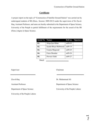
  • 1. Construction of Satellite Ground Station Page1 Certificate A project report on the topic of “Construction of Satellite Ground Station” was carried out by undersigned students of BS (Hons., Session: 2009-2013) under the supervision of Sir Zia-ul- Haq, Assistant Professor, and same are hereby submitted to the Department of Space Science, University of the Punjab in partial fulfillment of the requirements for the award of the BS (Hons.) degree in Space Science. Dated: Supervisor Chairman Zia-ul-Haq Dr. Muhammad Ali Assistant Professor Department of Space Science Department of Space Science University of the Punjab, Lahore University of the Punjab, Lahore Serial No Names Roll no. Signature 01. Atiqa Ijaz Khan ss09-03 02. Syeda Rbiya Mehmood ss09-14 03. Usama Maqsood ss09-25 04. Faiza Shoukat ss09-26 05. Pervaiz Elahi ss09-27
  • 2. Construction of Satellite Ground Station Page2 Dedication This project report is dedicated to our respected teachers and parents who made us to see the height of this achievement.
  • 3. Construction of Satellite Ground Station Page3 Acknowledgement All praises, to ALLAH Almighty, the most Merciful and Beneficial. And all the Blessings from Almighty on us Who is the everlasting source of knowledge and wisdom. Foremost we would like to pay our sincere gratitude to our Supervisor, Sir Zia-ul-Haq, for his continuous support and assistance for our project study and report. We are very grateful to our Chairman, Dr. Muhammad Ali, for providing us with such an environment so to complete our project on time successfully. We are also thankful to our respectable teachers for their immense knowledge throughout the 4-year degree program. So by here we are in a position of submitting our final year project report. We would like to Ronnie Nader, 1st Ecuadorian Astronaut / Mission Director at EXA, for his support and help regarding online tracking using HERMES Project.
  • 4. Construction of Satellite Ground Station Page4 Table of Contents 1) Abstract 09 2) Chapter 1: Introduction 11 3) Chapter 2: The Satellite System 14 a. Types of Satellites 14 i. Communication Satellites 15 ii. Earth Observation Satellites 16 iii. Navigation Satellites 17 iv. Military Satellites 17 v. Special Satellites 18 vi. Remote Sensing Satellites 18 vii. Weather Satellites 19 b. Component of Satellites 19 i. Payload 20 ii. Bus 20 c. Weather Satellite System 26 i. Categories of Weather Satellite System 26 ii. Working with Weather Satellites 28 iii. Weather Satellite Imagery System 29 4) Chapter 3: Working with NOAA 34 a. NOAA Satellite Series 34 b. Orbital Properties 37 c. Modes of Operation 38 d. NOAA Frequencies 38 e. Modulation Techniques 39 5) Chapter 4: Weather Satellite Receiver 41 a. Receiving System of Weather Satellites 41 b. Modes of Reception of Weather Satellites 43 c. Transmission Parameters for POES Satellite System 45 6) Chapter 5: Automatic Picture Transmission System 48 a. APT Transmission Format 49 b. Requirements for Building an APT System 50 7) Chapter 6: Construction of Antenna 56
  • 5. Construction of Satellite Ground Station Page5 a. Omni-directional Antennas 56 b. Directional Antennas 57 c. Cross Antennas 58 d. Double Cross Antennas 58 e. Why we choose Double Cross Dipole Antenna? 60 f. Construction 61 i. Calculation of Dipole Rod Length 63 8) Chapter 7: Introduction to Wpeix 2000 B Receiver 65 a. Calibration 65 b. Selection Criteria for Receiver 66 9) Chapter 8: Introduction to WXtoImg 69 a. Software Features 69 b. Versions 69 c. Calibration 70 d. Why we choose WXtoImg? 74 e. Sample Images 75 10) Chapter 9: Online Tracking of Satellite Images 77 a. Background 77 b. Project Hermes 78 c. Modes of Operation 79 d. Implementation of Delta Mode 80 e. Future Expansion 82 11) Issues and Problems 84 12) Conclusion 85 13) Recommendation 86 14) Glossary 87 15) Performance 94 16) Software List 96 17) References 97
  • 6. Construction of Satellite Ground Station Page6 List of Figures 1. Figure: Satellite 14 2. Figure 01: ANIK 16 3. Figure 02: Quick Bird 16 4. Figure 03: Navstar 17 5. Figure 04: Military Satellite 17 6. Figure 05: Galileo 18 7. Figure 06: Landsat 18 8. Figure 07: Meteosat 19 9. Figure 08: Component of Satellite 20 10. Figure 09: GOES 24 11. Figure 10: POES 27 12. Figure 11: GOES GVAR (United East Cost) 28 13. Figure 12: HRPT (Hurricane Emily) 42 14. Figure 13: APT (Europe) 42 15. Figure 14: WEFAX and HRI (Europe) 43 16. Figure 15: Commercial Pre-amplifier 45 17. Figure 16: APT Transmission Format 46 18. Figure 17: APT Ground Station 49 19. Figure 18: Antenna Requirement 50 20. Figure 19: WeSaCom APT-06 53 21. Figure 20: R2FX 53 22. Figure 21: Hamtronics 54 23. Figure 22: EMGO 54 24. Figure 23: Cross Dipole Antenna 58 25. Figure 24: Double Cross Dipole Antenna 59 26. Figure 25: Double Cross Dipole Antenna 59 27. Figure 26: Pipes of Antenna 61 28. Figure 27: Holders of Antenna 61 29. Figure 28: Pipes Assembly 62 30. Figure 29: Final Antenna 62 31. Figure 30: Dipole Phasing 63 32. Figure 31: Wpeix 2000 B 65
  • 7. Construction of Satellite Ground Station Page7 33. Figure 32 Enter Your Location 71 34. Figure 33: Satellite Pass list 71 35. Figure 34: Volume Adjustment 72 36. Figure 35: Slant Correction 73 37. Figure 36: WXtoImg Interface 73 38. Figure 37: A Typical Decoded Image by WXtoImg 75 39. Figure 38: MSA Enhanced Image by WXtoImg 75 40. Figure 39: Sample Image by Project Hermes 77 41. Figure 40: Hermes Working 79 42. Figure 41: Implementation of Project Hermes 80 43. Figure 42: VRS Monitor 81 44. Figure 43: Listen Connection 81 45. Figure 44: Delta Client Side 82 46. Figure 45: Future Expansion 83 47. Figure 46: APT Setup 94 48. Figure 47: Audio Files of WXtoImg 94 49. Figure 48: NOAA 15 Image on WXtoImg 95
  • 8. Construction of Satellite Ground Station Page8 List of Tables 1. Table 01: Satellite Categories 15 2. Table 02: Comparison of Satellites 31 3. Table 03: Comparison between Polar and Geostationary Satellites 32 4. Table 04: GOES 35 5. Table 05: NOAA 36, 37 6. Table 06: Orbital Properties of NOAA 37 7. Table 07: Modes of Operation 38 8. Table 08: NOAA Frequencies 38 9. Table 09: NOAA Modulation Techniques 39 10. Table 10: US POES Satellite Parameters 45 11. Table 11: Properties of APT 48, 49 12. Table 12: Comparison between Cross And Double Cross Antenna 60 13. Table 13: Comparison of Double Cross Antenna 60 14. Table 14: Comparison of Wpeix 2000 B 66 15. Table 15: Versions of WXtoImg 69, 70 16. Table 16: Comparison of WXtoImg 74
  • 9. Construction of Satellite Ground Station Page9 Abstract The world has progress to the century of technology where everything is in the click of a second. Satellite images are one of the key aspects of advancement of this era. There come many methods to deal with these images for educational, scientific, re-search, and military purposes. The basic thing to do is to obtain them for a user. In order to provide this facility, one of the applications is APT that is Automatic Picture Transmission. That is actually a low resolution image by low orbiting satellites like NOAA. The main objective of this project report is to establish an APT ground station to meet the educational purposes of the student of our Department of Space Science, University of the Punjab. It comes with antenna and decoder. This project report highlights the working and building of an APT station at a reasonable cost. In future, the room of modification is still available; it is just a starting towards the higher goals.
  • 10. Construction of Satellite Ground Station Page10 Chapter 01
  • 11. Construction of Satellite Ground Station Page11 Introduction In the last few decades, the satellite reception system is more into consideration. The weather satellite receiving system has evolved with time and come to this stage of advancement. Now it is affordable for even small institute and department to have their satellite ground station. That is in return one step forward at the educational level. NOAA is the most easily available satellite for the weather reception. The technique used here is of automatic picture transmission (APT). There are two modes of this operation. Satellite imagery can be accessed by formally building an APT ground station, using antennas, amplifier, decoders and software. Secondly it can also be tracked by online systems. This project report is started from the general information about the satellites and its types. Weather satellite reception system is the key towards the better understanding of this system, so this topic is also discussed here. It then mainly focused on the NOAA satellites and its reception system, as per our need. NOAA polar orbiting satellite system is the foremost requirement of the APT. As the APT operate on polar satellites. Building of an APT ground station requires a little basic work on the antennas. As antennas are building blocks of any reception system. For signals to receive properly, another important part is pre-amplifier. The strength of the signal is mostly depended upon the area where the signal is receiving. Other factors are also there. As a result, the APT catches the signal as satellite passes through our mandatory track. Then it is further decoded by the help of software, such as WXtoImg. Now the images are ready for any kind of analysis. For the satellite images to be captured and displayed, the setup requires a receiver. The quality of the receiver defines the resolution of the images. This is an important portion of an APT system. The apparatus used here is Wpeix 2000 B. There many software available for tracking as well as decoding of the satellite images. It is up to user demand, which software can display the finest images to meet up the demands of users. They are all there in internet in free version and paid ones. Obviously, the paid one carries the greatest features with it, which is a helpful key for experts.
  • 12. Construction of Satellite Ground Station Page12 Another approach is here in the favor satellite reception system. Online tracking is available now days. It gives the real time tracking of the satellite to the remote users. It gives relief to thousands of users. As it is less than one click distance. Another option for obtaining the satellite data is to get connected with Project Agora, Hermes. By this way, the University should have a cooperation contract with EXA. Then they generate the user name and password. We have to provide them with our public IP address. After completing all this steps, it is now available for us to get the satellite images on our pc. These images can be further used in analysis from a layman to students, teachers, experts, researchers, scientists, and all other fields. These images are also for military purposes.
  • 13. Construction of Satellite Ground Station Page13 Contents Types of Satellites Communicational Sat Earth Observing Sat Navigation Sat Military Sat Special Sat Remote Sensing Sat Weather Sat Component of Satellite Merits De-merits Weather Satellite System Categories Working Satellite Imagery Chapter 02Chapter 02
  • 14. Construction of Satellite Ground Station Page14 The Satellite System o deal with satellite system, the knowledge of the satellite is essential. Without this, it is impossible to understand the processes of the satellite systems. According to Frenzel, “A satellite is a physical object that orbits a celestial body.” Some satellites are natural, as the moon which is the natural satellite of earth. Some satellites are made by scientists to go around the earth. These satellites provide us with valuable information regarding weather, remote sensing etc. for communication satellites remain fixed above the surface of earth and provide worldwide information. Some satellites are for sending and receiving the signals. These signals are sent from a space station on the surface of earth. These satellites receive the signal and re-broadcast it to other places on the earth. Some satellites sent and receive fax, telephone and computer communication. Other satellites observe the weather, feeding weather information into giant computers programs that help scientists know what the weather will be. All weather reports on our TV news program are getting their information from these satellites. Figure: Satellite Some satellites take pictures of earth‟s surface, sending back images that tell scientists about changes that are going on around the world. Types of Satellites On the basis of usage, satellites are divided into following categories: T
  • 15. Construction of Satellite Ground Station Page15 1. Communication satellites 2. Earth Observation satellites 3. Navigation satellites 4. Military satellites 5. Special satellites 6. Remote sensing satellites 7. Weather satellites Table 1: Satellite Categories Communication Satellites: Communication satellites are used for audio, video and data transmission. They carry large dishes to capture radio waves and heavy solar panels for powering the sound amplifiers. Their orbit is geosynchronous 22300 miles above earth‟s equator. Examples:  Sputnik-1
  • 16. Construction of Satellite Ground Station Page16  Nimbus-3  Westar-1  Arabsat-1A  Badar  TIROS-1 Figure 1: Courtesy: NASA Glenn Research Center (ANIK) Earth Observation Satellites: Earth observation satellites are used for photographing the earth to observe changes such as earthquakes, and floods etc. They are at low flying orbits at 90-300 miles. Examples:  MOS-1/1b  JERS-1  ADEOS  ADEOS-II  ALOS Figure 2: Courtesy: www.digitalglobe.com (Quick Bird)
  • 17. Construction of Satellite Ground Station Page17 Navigation Satellites: These satellites are used for global positioning system. It means that we can navigate by a satellite. They orbit at around 90-300 miles. Figure 3: (Navstar) Courtesy: www.tele.ntnu.no/radio/newresearch/navigation/avion.jpg Examples:  GIOVEA & GIOVE B  GLONASS-M  PARUS  Navstar Military Satellites: These satellites are used to control the military activity of the country. It usually power up the systems. Their designs are still not public. They are at both high and low orbits, may be up to 22,300 miles. They are approved in 1960‟s. And now become an important part of defense system. Examples:  COSMOS  SKYNET  MUOS Figure 4: Courtesy: US Department of Defense  REX  STRV 1A & 1B  RADCAL SAT
  • 18. Construction of Satellite Ground Station Page18 Special Satellites: These satellites are used for space observation and re-search work. Space station is one of its examples. It orbits at low altitudes. While on the other hand, deep space probes travel in an elliptic orbit. Examples:  Galileo  Mir Space Station  Mariner 9 Mars Orbiter  Magellan Venus Orbiter Figure 5: (Galileo) Courtesy: NASA Glenn Research Center Remote Sensing Satellites: Remote sensing satellites provide a systematic way of observing physical phenomenon and processes taking place on human‟s planet. In remote sensing scientists described that information transfer from the object or phenomenon to a sensor by electromagnetic spectrum. Sensor is placed on a satellite which is specific for a particular portion of spectrum to detect various objects. Therefore in remote sensing satellite the sensor play main role. Figure 6: Courtesy: www. landsat.gsfc.nasa.gov.htm Examples:  Landsat (USA)  SPOT (France)  IRS (India)  Envi-sat (ESA)
  • 19. Construction of Satellite Ground Station Page19  RADARSAT (Canada)  IKONOS  Quick bird  Orb View Weather Satellites: These satellites are used for photographing changes in cloud formation and climatic and weather conditions. They have design in similar to earth observation satellites. A Low-flying polar satellite circles every 2-hour at 300-600 miles above earth. Examples:  Meteosat  COMS  GOES  NOAA  MTSAT-1R  TIROS 1-10  ORBVIEW-2(Sea star) Figure 7: (Meto-sat) Courtesy: Richmond University, VA, Teacher resources at oncampus.richmond.edu Component of Satellites A satellite consists of two main units:  Payload  Bus
  • 20. Construction of Satellite Ground Station Page20 Figure 8: Communication Network Payload: It is the part of the satellite that provides communication. Payload further consists of two main parts: i. Repeater which receives the uplink signal amplifies it and converts it into suitable downlink frequency. ii. Antenna receives and transmits the signals to the ground stations. Bus: It provides all the necessary electrical and mechanical support to the payload. Function of Bus:  Maintain the correct orbital position of the satellite at any specific location and to keep the antennas pointing towards the required location. (AOCS)  Providing communication between the satellite and the ground stations by accepting and conveying commands from and to the ground stations. Commmunication Network Space segment Payload & bus Earth segment Earth receiving station station Antenna
  • 21. Construction of Satellite Ground Station Page21  Providing the DC power to all the operative components of the satellite (Power Sub system)  Maintain the suitable temperature of various subsystems of the satellite Bus consists of further components: TTC (TELEMETRY, TRACKING & COMMAND) a) Telemetry  It is used to report the status of the onboard systems of the satellite to the ground stations.  The telemetry subsystem consists of 100 different electronic sensors that are used to measure temperature, radiation level, power supply voltage, fuel pressure etc.  By that ground stations are able to know to the current status of the satellite.  At the earth stations a computer can be used to monitor, store and decode the telemetry data so that the status of any system or sensor on the space craft can be determined immediately by the earth station. b) Tracking:  Tracking system is important during the orbital drifting phase of the satellite.  Beacon transmitters are usually provided on the space craft for tracking during the launch and operation.  When a geostationary satellite tries to shift due to different disturbing forces the tracking system becomes real important that tracks the satellite exact position.  Precise measurements of range is calculated by transmitting a pulse or a sequence of pulses to the satellite and noting the time delay before the pulse is received again.  The propagation delay in the satellite transponder must be known accurately and more than one earth station could be used to make range measurements.
  • 22. Construction of Satellite Ground Station Page22 c) Command:  It receives the instructions from satellite ground stations, decodes the instructions and send the commands back to the satellite for verification.  Basically the satellite contains a command receiver which receive signals transmitted from earth stations.  The commands that are received by the satellite from earth stations are passed to the computer from where they are processed for necessary action. AOCS:  The purpose of AOCS is to provide the attitude determination and control to maintain and sustain the required geostationary position.  The attitude of the satellite should be controlled so that the antennas could be pointed be pointed towards the correct location on the earth.  Attitude control is also necessary in some satellites to keep the satellites solar panels pointing towards the sun so as to get the maximum solar radiations at all times.  AOCS is maintained by satellite stabilization method and jet thrusters firing.  AOCS is first calculated when the satellite enters into its required GEO & becomes stable. PSS:  The function of the power subsystem is to provide DC power to all subsystems throughout the life of a satellite.  For this requirement, the PSS must generate DC power, regulate it and provide an alternative source when power cannot be generated by the space craft.  The early satellites used onboard batteries for power-up but these batteries were exhausted quickly and could not be replaced.  Life of a satellite depends upon quality of the batteries and power drain.  Presently solar panels onboard the satellites are the basic power source.  On these solar panels lie a large no. of photocells connected in series and parallel and can generate many kilowatts of energy.
  • 23. Construction of Satellite Ground Station Page23  At times when the satellite goes into the eclipse means that the solar panels are deprived of solar radiations and that time the solar batteries come into the action.  These batteries are not that large to give power for a longer time to the satellite.  It means that batteries are only used for a backup system in eclipses, in initial satellite orientation and emergency conditions.  Its is mostly recommended that solar cells should be connected in parallel rather than in series.  The operational status of the batteries (recharging, service etc) is controlled by the ground stations.  Presently Ni-Cd batteries are used due to their high reliability and long life time. Pyro Propulsion Subsystem  The function of the propulsion system is to generate thrust required for attitude and orbit corrections.  The thrust required for attitude and orbit correction is large and mono propellants and bi-propellants fuels are used for it. Force required by a thruster depends on the flow rate of the fuel and specific impulse.  All the communication satellites require a propulsion subsystem to take the satellite up, for its proper orientation, to put it into transfer orbit and finally into GEO. Thermal Control Subsystem  It is very important that the mean space craft temperature and the temperature of all the subsystems should be maintained in suitable limits (not too high that the space craft may blast and not too low that the liquid fuel may freeze)  This subsystem mainly consists of passive devices that include thermal blankets that lie on the exterior of the satellite which prevents the satellite from over heating.  It also contains controllable heaters that are either controlled by the satellite automatically or by the earth stations automatically through TTC link.
  • 24. Construction of Satellite Ground Station Page24 The performance and reliability of everything in the spacecraft is more or less temperature sensitive. Figure 9: Components of satellite Merits of Satellites: Following are the merits of satellites:  Satellite covers every portion of earth either customer is in rural area or urban area.  Satellite communication is not effected by the terrain of earth.  With the increase in distance between user and communication point there is no increase in cost  Additional receive sites on a network can be added in few hours.  Satellite services are highly flexible.  Recently satellite technology has been used to connect internet with broadband connections.  Satellite data is helpful for understanding and analyzing the global environmental conditions  It is helpful to found earth natural resources. Data collected from satellites is making able us to understand the processes and interactions among land masses, oceans and atmosphere.
  • 25. Construction of Satellite Ground Station Page25 De-merits of Satellites: With the development in every field of life the technology is advanced and there are better ways of doing everything. Decades ago people have no choice but to travel distance but now communication via satellite is available. Satellite with thousands of advantages having some disadvantages which are as follows:  Satellite dealing is bit expensive.  As satellite is at large distance from earth so a time lag between the messages sent and received.  Satellite data transfer is susceptible to noise and interference  The bandwidth of satellite is becoming used up with time.  Congestion of frequencies Note: While discussing the satellite systems, not all the satellites facilitate us with the option of APT (Automatic Picture Transmission). Now a day it is only available with us for the weather satellites only as they (few of them) gives the facility for APT that can be used by any of the end users specially students and researchers. Also APT is mainly used in the meteorological and weather forecasting field only. So now we are going to focus our attention to the weather satellites in particular.
  • 26. Construction of Satellite Ground Station Page26 Weather Satellites System eather satellites make it possible to observe world wide areas. Cloud images are the one of the best satellite application and also other meteorological parameters can be measured from satellites. Categories of Weather Satellites There are following two basics types of weather satellites:  Geostationary Orbiting Satellites  Polar Orbiting Satellites Few important details about them are discussed below: Geostationary Weather Satellite: Geostationary satellites orbit the earth in the same time as it takes the earth to revolve once. These satellites appear still from the earth. The geostationary orbit allows the satellite to monitor the same region all the time. Geostationary satellites transmit photographs to the receiving system on the ground as soon as the camera captures the picture. The series of the captured photographs from these satellites can be displayed in a sequence to generate a movie showing cloud movement. It allows the forecasters to watch the large weather systems. Wind direction and speed by monitoring cloud movement is also finding out. GOES satellites make day and night observations of weather in a specific area and transmit real-time VISSR data. From Hawaii to Maine, land features can be examined at 0.8 km. resolution. It is the primary function of GOES satellite is to provide imagery of varying resolution. W
  • 27. Construction of Satellite Ground Station Page27 Merits:  It can view the whole earth at all times.  It always locates at the same place relative to the earth.  It can take and record images as fast as once every minute. Figure 10: GOES  Motion of clouds can be computed because its view is always from same perspective.  It also receives transmissions from free-floating balloons and automatic data collection station around the world. De-merits:  It provides less detail view of the earth as it located about 35,000 km in space.  Due to the earth curvature views are limited. Polar Weather Satellites: It is the other basic type of weather satellite. It is a type of satellite that orbits in a path that closely follows the Earth's meridian lines, each revolution. As the Earth rotates to the east under the satellite, each pass of the satellite monitors a small area running from north to south, and, to the west of the previous pass. These strips can be pieced together to generate a picture of a wide area. These satellites circle at lower altitude about 850 km. As polar satellites can photograph clouds from closer than the high altitude geostationary satellites therefore provide more detailed information about storm, wind or cloud system. TIROS are a polar orbiting satellite (NOAA-class) that is launched by United States.it is the principle source of environmental data. Temperature, humidity in the earth surface is measured by these satellites. These also monitor cloud cover. To locate downed airplanes or ships in distress it also carries Search and Rescue (SAR) transponders. Polar orbiting
  • 28. Construction of Satellite Ground Station Page28 satellites send back pictures to earth station via Automatic Picture Transmission (APT). Figure 11: POES Merits:  These are closer to the earth with an orbit of about 833 km above the surface.  The images obtained by polar orbits are more detailed.  They give fabulous view over Polar Regions. De-merits:  These cannot see the whole earth‟s surface at any one time.  As the path of each orbit changes due to the earth‟s rotation so images of same location are not obtained.  As most of the time the satellite is below the earth‟s horizon so it is limited to about six or seven images a day. Working of Weather Satellites Weather satellites carry an instrument which is called radiometer (not cameras) that scans the Earth to generate images. Radiometers usually have some sort of small antenna or telescope, any scanning mechanism, and detectors that detect either visible, infrared, or microwave radiation with the aim of monitoring weather systems all over the world.
  • 29. Construction of Satellite Ground Station Page29 The data are then provided to various weather forecast centers of world and available over the internet in the form of images. The time from satellite measurements to image availability can be less than a minute because weather changes quickly. The life span of instruments on the satellites is 3 to 7 years, although many of them last longer than that. Weather Satellite Imagery Environmental satellites data is provided in several different formats. The most commonly used formats on weather satellites used are the visible, infrared, and water vapor channels. They are of three types:  Visible Imagery  Infrared Imagery  Water Vapor Imagery Visible Satellite Imagery: VIS imagery shows the amount of solar radiation reflected from the surface of earth. A VIS image is an approximation of the percentage of incoming sunlight reflected by a surface called albedo. In satellite VIS imagery, highly reflective areas are represented by lighter tones and low reflective areas are represented by dark tones. On the surface of earth the features vary in their reflectivity therefore can be easily distinguished by VIS image. In Visible Imagery  Thick clouds appears white  Thinner clouds appear in light medium gray tones.  The oceans appear nearly black.  The land on the nature of the surface features appears as various shades of gray.
  • 30. Construction of Satellite Ground Station Page30 Infrared Satellite Imagery: The IR sensors measure the amount of infrared energy emitted by the surface of earth and atmosphere. In this type of imagery the amount of energy emitted depends on the temperature of the surface. This information can be used to measure thermal proportion of the earth. in conventional IR imagery the colder areas appear as light gray tones i.e. white and warm areas appear dark tones of gray i.e. black. The scale of an infrared image is composed of 256 gray shades ranging from white representing coolest temperature to black representing warmest temperature. In Infrared imagery:  The highest or coldest cloud tops appear white.  Low clouds may appear in light shades of gray.  Water surface appears darker shades of gray. Water Vapor Satellite Imagery: As the earth and atmosphere emit energy then the clouds and suspended water vapors absorb specific wavelength. The remaining energy is transmitted through the atmosphere. Most IR sensors take advantage of the infrared band because it allows accurate measurements of temperature of earth and tops of clouds. Some satellite sensors study the radiation absorbed and by studying the IR energy at these wavelengths the atmospheric gas concentration can be studied without the interference of surface features of earth. The widely used applications of this concept are channel 9 (7.3 microns) and channel 10 (6.7 microns) on GOES VISSR sensor. Energy present in this channel is absorbed by water vapors. The images that are taken in these channels are used to point out large concentration of water vapors. In Water Vapor imagery:  The darker regions are the areas where very less amount of water vapor exists.  The lighter regions are very moist.
  • 31. Construction of Satellite Ground Station Page31 Water vapors are very important tool for weather analysis and prediction because it not only shows the cloud pattern but also shows the moisture content in the atmosphere. This allows the meteorologists to observe large scale circulation patterns even in the absence of clouds. Note: After discussing the weather satellites in general, we are now going for the NOAA satellites. They are under special consideration as this series (NOAA satellite series) is the most authentic data provider globally and is majorly available to layman for free. And most of all it is equipped with APT Setup. A general comparison is given here that shows why we chose NOAA. Sr.No Satellite Operational Status APT* HRPT* LRT* 01. Trios -- Yes No No 02. Nimbus -- Yes No No 03. NOAA Yes Yes Yes No 04. Meteosat Yes No Yes Yes 05. MetOp Yes No Yes Yes 06. Insat Yes No Yes Yes 07. Metsat Yes No Yes Yes 08. GOES Yes No Yes No 09. Electro Yes No Yes Yes 10. Feng Yun Yes No No Yes Table 02: Comparison of Satellites * APT (Automatic Picture Transmission), HRPT (High Resolution Picture Transmission), LRT (Low Resolution Transmission) Our main focus is on polar satellites not on the geo-stationary satellites. The few of the reason behind them are as follows: Options Geo-stationary Satellites Polar Satellites Weather Satellite Yes Yes
  • 32. Construction of Satellite Ground Station Page32 APT No Yes HRPT Yes No Complexity of antenna More than Polar, expensive Less than Geo-stationary, cheap Availability of receivers Expensive Cheap Decoder Complex Programming Easy Programing Table 03: Comparison between polar and geo-stationary Now it is clear from the above mention facts, that the NOAA satellite best serve our purpose. That is in-return a polar satellite. In the next section, we will explore the NOAA satellites.
  • 33. Construction of Satellite Ground Station Page33 Contents NOAA Satellite System Orbital Properties Modes of Operation NOAA Frequencies Modulation Techniques Chapter 03
  • 34. Construction of Satellite Ground Station Page34 Working with NOAA Satellites he NOAA_ “The National Oceanic and Atmospheric Administration” along with the collaboration of the NASA_ “The National Aeronautics and Space Administration” has a major role in the development of the satellite programs. NOAA has a renowned history in the establishment of the weather satellites from “Polar Orbiting Environmental Satellites” (POES) to “Geostationary Orbiting Environmental Satellites” (GOES). Started from the momentous moment on April 1, 1960, when the world first weather satellite was launched named TRIOS (Television Infrared Observation Satellites) from Cape Canaveral, FL under the supervision of NOAA. Followed by the series of NOAA-1 launched in the year 1970.Then by the joint effort of NOAA and NASA, they launched the series of TRIOS-N (the TRIOS Next generation) by mid-1970. At present time, the NOAA-19 is the fifth and last of its kind launched by 2006. This then turned to the successful, ever growing technological advancement in this field till now the year 2013. The NOAA Satellites Series Under the NOAA, it launched two major series of satellite age:  Geostationary Orbiting Environmental Satellites (GOES)  Polar Orbiting Environmental Satellites (POES) They have one major difference that is; POES series capture the earth on the orbital locations where normally geostationary satellites are unable to capture the images. The geostationary satellites have the potential to get the full east or west disk of the earth as per requirement. Below are given the summary of the satellites launched by the NOAA for polar as well as geostationary satellites. T
  • 35. Construction of Satellite Ground Station Page35 Geostationary Orbiting Environmental Satellites (GOES): Following are the GOES series of NOAA satellites: Series No. NOAA Satellites Launched Date Current Position Series 01. SMS-1 May 17, 1974 De-active SMS-A 02. SMS-2 Feb 06, 1975 De-active SMS-B 03. GOES-1 Oct 16, 1975 De-active GOES-A 04. GOES-2 Jun 16, 1977 De-active GOES-B 05. GOES-3 Jun 16, 1978 De-active GOES-C 06. GOES-4 Sep 09, 1980 De-active GOES-D 07. GOES-5 May 22, 1981 De-active GOES-E 08. GOES-6 April 28, 1983 De-active GOES-F 09. GOES-7 -- De-active -- 10. GOES-G May 03, 1986 De-active -- 11. GOES-7 Feb 26, 1987 De-active GOES-H 12. GOES-8 April 13, 1994 De-active GOES-I 13. GOES-9 May 23, 1995 De-active GOES-J 14. GOES-10 April 25, 1997 De-active GOES-K 15. GOES-11 May 03, 2000 De-active GOES-L 16. GOES-12 July 23, 2001 Active GOES-M 17. GOES-13 May 24, 2006 Active GOES-N 18. GOES-14 Jun 27, 2009 Active GOES-O 19. GOES-15 Mar 08,2011 Active GOES-P Table 04: GOES list Where, SMS = Synchronous Meteorological Satellite Program GOES = Geostationary Orbiting Environmental Satellites
  • 36. Construction of Satellite Ground Station Page36 Polar Orbiting Environmental Satellites (POES): Following are the list of the NOAA polar satellite series, sorted by the launching dates: Serial No. NOAA Satellites Launched Dates Current Position Series 01. TRIOS-1 April 01, 1960 De-active -- 02. TRIOS-2 Nov 23, 1960 De-active -- 03. TRIOS-3 July 12, 1961 De-active -- 04. TRIOS-4 Feb 08, 1962 De-active -- 05. TRIOS-5 Jun 19, 1962 De-active -- 06. TRIOS-6 Sep 18, 1962 De-active -- 07. TRIOS-7 Jun 19, 1963 De-active -- 08. TRIOS-8 Dec 23, 1963 De-active -- 09. TRIOS-9 Jan 22, 1965 De-active -- 10. TRIOS-10 July 02, 1965 De-active -- 11. ITOS-1 Jan 23, 1970 De-active TRIOS 12. NOAA-1 Dec 11, 1970 De-active ITOS-A 13. ITOS-B Oct 21, 1971 De-active -- 14. NOAA-2 Oct 15, 1972 De-active ITOS-D 15. ITOS-E July 16, 1973 De-active -- 16. NOAA-3 Nov 06, 1973 De-active ITOS-F 17. NOAA-4 Nov 15, 1974 De-active ITOS-G 18. NOAA-5 July 29, 1976 De-active ITOS-H 19. TIROS-N Oct 13, 1978 De-active -- 20. NOAA-6 Jun 27, 1979 De-active NOAA-A 21. NOAA-B May 29, 1980 De-active -- 22. NOAA-7 Jun 23, 1981 De-active NOAA-C 23. NOAA-8 Mar 28, 1983 De-active NOAA-E 24. NOAA-9 Dec 12, 1984 De-active NOAA-F 25. NOAA-10 Sep 17, 1986 De-active NOAA-G 26. NOAA-11 Sep 24, 1988 De-active NOAA-H 27. NOAA-12 May 14, 1991 De-active NOAA-D 28. NOAA-13 Aug 09, 1993 De-active NOAA-I
  • 37. Construction of Satellite Ground Station Page37 29. NOAA-14 Dec 30, 1994 De-active NOAA-J 30. NOAA-15 May 13, 1998 Active NOAA-K 31. NOAA-16 Sep 21, 2000 Active NOAA-L 32. NOAA-17 Jun 24, 2002 De-active NOAA-M 33. NOAA-18 May 20, 2005 Active NOAA-N 34. NOAA-19 Feb 06, 2009 Active -- Table 05: NOAA list Where, TRIOS = Television and Infrared Observational Satellites ITOS = Improved TRIOS Operational Satellites TRIOS-N = TRIOS Next Generation Orbital Properties The orbital characteristics of the currently activated NOAA satellites are given below: Serial No. NOAA Satellites Inclination (Degrees) Altitude (km) Time Period Operational Status Type 01. NOAA-15 98.5 807 101.1 min AM Secondary Sun- Synchronous 02. NOAA-16 99.0 849 102.1 min PM Secondary Sun- Synchronous 03. NOAA-18 98.74 845 102.12 min PM Secondary Sun- Synchronous 04. NOAA-19 98.7 870 102.14 min PM Primary Sun- Synchronous Table 06: Orbital Properties of Currently Active Satellites
  • 38. Construction of Satellite Ground Station Page38 Modes of Operation NOAA data reception can be easily conducted by the aid of fully equipped ground station within the radio frequency range. This is called Direct Readout. It deals with the two types of services of AVHRR: 1. HRPT (High Resolution Picture Transmission) 2. APT (Automatic Picture Transmission) Serial No. NOAA Satellites HRPT Data Transfer Rate (Kbit/sec) APT Data Transfer Rate (Kbit/sec) 01. NOAA-15 Yes 665 Yes 9.6 02. NOAA-16* Yes 665 No 9.6 03. NOAA-18 Yes 665 Yes 9.6 04. NOAA-19 Yes 665 Yes 9.6 *As NOAA-16 does not carry APT, so it is omitted in the further discussion in this document. Table 07: Modes of operation NOAA Frequencies For currently activated NOAA satellites, the operational frequencies of these are as follows: Serial No. NOAA Satellites Frequencies (MHz) 01. NOAA-15 137. 35 & 137.62 02. NOAA-18 137.35 & 137.9125 03. NOAA-19 137.77 & 137.10 Table 08: NOAA Currently Active Satellites Frequencies
  • 39. Construction of Satellite Ground Station Page39 NOAA Modulation Techniques The NOAA currently activated satellites works on different kind of modulation process as follows: Serial No. NOAA Satellites Modulation 01. NOAA-15 PCM/PM AM/FM 02. NOAA-18 PCM/PM AM/FM 03. NOAA-19 PCM/PM AM/FM Table 09: NOAA Modulation Techniques Where, PCM = Pulse Code Modulation PM = Phase Modulation AM = Amplitude Modulation FM = Frequency Modulation The APT acquires data whenever the satellite is in the range. For NOAA, it passes 4 times daily. The number of satellites passes depends upon the latitude of the station. High station can get transmission more than 4 times a day. But each station receives data only for 15 minutes, while the satellite is in the range.
  • 40. Construction of Satellite Ground Station Page40 Contents Receiving System Modes of Reception Transmission Parameters of POES Chapter 04Chapter 04
  • 41. Construction of Satellite Ground Station Page41 Weather Satellite Receiver Introduction n order to receive the satellite images, the basic requirement is of the receiver. Here few questions rises what is a receiver? What types of receiver are weather satellite receivers? How it works? The type and quality of the receiving system of satellite images defines the how good are images. According to Frenzel, “A receiver is a component, as a function and portion that obtain arriving radio signals or transfer them in a usable form.” What is a Receiver? Receiver essentially executes different operations. It extracts the desired signal from the signals that is getting by antenna that may contain un-desired signals. Receiver eliminates all un-desired signals. Receiver also sufficiently increases the wanted signals to a useable quality. Ultimately the receiver retrieves the wanted signal and gives it to the utilizer. Receiving System of Weather Satellite Obtaining signal from weather satellite is not simple as it looks. Different factors are responsible in obtaining a clear and good image in throughout the transmission. The primary difficulty is that signal transmitted by satellite is polarize and is not very strong. In different situation directional antennas can be used to get good results. Different very high frequency (VHF) receiver can obtain the band of satellite at 137 MHz range frequency modulation. However they mostly have missing adequate sensitivity to get a good or noise eliminated signal. Scanners also have problem, they receive signal at very narrow bandwidth, as it is optimum for the noise signal. On the other hand, the weather satellite NOAA needs a broader bandwidth receiver, however not broader as that utilize for broadcast FM signals. The impact of obtaining signals at limited bandwidth is that big signals show the luminous portion of signal, are cut off. Currently, few of the weather satellite receiving system are available: I
  • 42. Construction of Satellite Ground Station Page42 1. GOES GVAR Satellite Receiving System: (morcom.com) This is a highly advanced PC-based work station or capturing real time high resolution images from geostationary satellites. Figure 12: United East Cost (morcom.com) 2. NOAA HRPT Satellite Receiving System: (morcom.com) This is a real time receiving and displaying polar orbiting satellites imagery. These images are under the AVHHR highly resolution. Figure 13: Hurricane Emily (morcom.com) 3. MSG Eumetcast Satellite Receiving System: (morcom.com) They work on the images received by Eumetcast via Eumetcast broadcasting route. Commercially work under C and Ku band worldwide.
  • 43. Construction of Satellite Ground Station Page43 4. APT Satellite Receiving System: This is an uncomplicated system work with low resolution images with low orbiting satellites. These satellites are powerful enough that one can obtain images at 10 degree above the horizon. It is a type FAX transmission mode by the aid of satellite. APT carries tow sensors: visible and infrared. Images from this system are receivable by 137 MHz frequency range antenna. Figure 14: Picture of Europe transmitted in APT mode by a NOAA satellite. It is post processed in false colors. Modes of the Weather Satellite Reception System There are so many weather satellites in world that are continuously transmitting their images. These are in different resolution, modes, and frequencies. Mainly they are of four types: 1. APT: Again APT comes for its long range availability. It is a fully assembled automated weather satellite reception system, with a special start and stop tone accepted by decoder. Its mode is in FM with 120 lines per minute.
  • 44. Construction of Satellite Ground Station Page44 2. WEFAX and HRI: It stands for Weather Facsimile work on AM mode with 240 lines per minute. It works best for polar as well as geostationary satellites. Unlike APT, it uses standard tone. Having a voice audio channel with AM carries of 2.4k Hz modulated with 1.6k Hz video signal. It works with METEOSAT, GOES, INSAT, and GOMS. WEFAX images are easiest to record with analog mode while HRI (High Resolution Image) images are high resolution. Figure 15: (Europe and Maghreb pictured by METEOSAT 7) 3. MSG: It transmits images in resolutions: low and high. Mostly in C band that ranges 3.7-4.2 GHz. 4. HRPT or CHRPT: They capture high resolution images by polar orbiting satellites. The resolution of the images is up to 1.1km/pixel. They are operating under the frequency of 1.69 GHz with analyzing 5- 10 multi spectral channels. But they carry 120MB space of the hard disk. So it is reserve for the experts.
  • 45. Construction of Satellite Ground Station Page45 Transmission Parameter for POES Reception System Receiving systems for POES are the main aspect for the quality control and resolution of the APT images. Mostly they are similar to FM high band, solid state receivers. These types of receivers are mostly used by police and fire departments. This is type of receiver can be modified to receive the NOAA downlinks. So every APT should meet the minimum requirements for the complete APT video reception. According to the United States, the following are the minimum parameters set for the APT reception system of POES satellites operating there: Serial No. Parameters U.S. POES 01. Frequency 137.9125, 137.62, 137.1 MHz 02. Carrier Modulation Analog FM/AM 03. Carrier Deviation +/- 17 KHz 04. Polarization Right hand Circular 05. Transmitting Power 5 watts Table 10: US POES APT Parameters Few important points should be kept in mind while choosing the receiving system are: 1. Frequency of the Transmitted APT: The APT band is 137-138 MHz. This is a very narrow band. So it is necessary to obtain a receiver that is capable of operating under these ranges. 2. Type of RF Signal Modulation: The signal can be modulated on FM or AM techniques. 3. Sensitivity of the Receiver: It means that the receiver should be able enough to detect the very low and weak signals. The noise should be filtered and should not affect the signal quality. 4. Selectivity of the Receiver:
  • 46. Construction of Satellite Ground Station Page46 It is the important area of transmitting signal. The receiver can be a radio receiver or a scanner. 5. Bandwidth of the Transmitted Signal: The bandwidth of the transmitting signal is effected by: a. Satellite transmission deviation: For ideal APT system, it could afford the deviation of +/- 20 KHz. b. Doppler shift: It causes the frequency shift as the satellite approaches and passes by. The ideal values for APT are 40 KHz. 6. Selection of Pre-Amplifier: Pre-amplifier means that it has to be mounted after the antenna but before the decoder. The use of pre-amplifier is to strengthen to weak signal. As the POES transmit signal at a very low strength, so a good quality amplifier is a must job. One should take care of the amplifier, because it has to expose itself to the environmental conditions. So it should be weather resistance and water repellent in order to achieve the long time use. They are needed for long feed lengths. The relatively shorter feed length does not involve any kind of amplifier. It is developed to attain the good quality and noise free signal. Figure 16: Commercial Pre-amplifier
  • 47. Construction of Satellite Ground Station Page47 Contents Introduction Transmission Format Requirements of Building an APT Ground Station Antenna Receiver Tacking Software Decoder Chapter 01Chapter 05
  • 48. Construction of Satellite Ground Station Page48 Automatic Picture Transmission System utomatic picture transmission (APT) uses modified vidicon tube TV cameras. It continuously transmits analog signal on VHF band (136-138 MHz). The resolution has been reduced to 4 km in order to capture the larger area but in a low resolution. Few of the important general characteristics of APT are as follows: Serial No. 01. Camera Diameter 2.54 cm 02. FOV (Field of View) 108 degrees 03. Focal Length 5.7 mm 04. Objective Lens f/1.8 05. Picture Capturing Time 8 sec 06. Picture Transmission Time 200 sec 07. Transmitting Power 5 watt (37dBm) 08. Carrier Modulation 2.4 kHz AM subcarrier on FM carrier (DSB), normally within the rage of 1500-2500 Hz 09. Polarization Right Circular (RCP) 10. Grey Scales 256 Levels (8-bit) 11. Operational Frequencies 136-138 MHz 12. Operational Imagery Channels Visible & IR 13. Day Time Imagery Mode Visible & IR 14. Night Time Imagery Mode Infrared (IR) 15. Signal Analogue A
  • 49. Construction of Satellite Ground Station Page49 16. Data Transfer Rate 120 lines per minute (lpm) or 2 lines/sec 17. Resolution 4km/pixel Table 11: General Properties of APT Considering the normal altitude of 700 km for APT system, the foot print of the satellite is all about 1200 km * 1200 km having the nadir with 7.6 km of resolution. APT Transmission Frame Format The APT data we received is continuously transmitted on analog signal, with two AVHHR (Advance Very High Resolution Radiometer) channels. Any of the channels can be chosen by the APT ground station. 1. A visible channel is used to provide day time imagery. Figure 17: (N. Benabadji, 2004) 2. One infrared (IR) channel is use to deal with day and night time imagery. 3. Second IR channel is used as a replacement of the visible channel in the night time. Each image frame has two main parts: I. On the left side of the image, synchronization pattern is shown in vertical black lines in each image. II. On the bottom, telemetry data is shown with other information in grey scales wedges.
  • 50. Construction of Satellite Ground Station Page50 Requirements for Building an APT Ground Station To get the images form the weather satellites using APT mode, the general hardware required for these are as follows: a) An antenna b) Receiver c) Tracking Software d) Decoder Figure 18: (N. Benabadji, 2004) Antennas: “An antenna or aerial as it is sometimes called is one or more electrical conductors of a specific length that radiate waves generated by a transmitter or that collect radio waves at the receiver.” (Frenzel, Communication Electronics, 3rd edition) Types of Antennas: Antennas are different of hundreds of types. Few of them are: a) Yaggi Antenna: One of the high gain antennas. They are normally designed for HF to UHF. b) Dipole Antenna: It is same that of the electrical conductors of varying length. It is under the type of omnidirectional antenna. c) Helical Antenna: By using conductors or multiple conductors to wind a helix, formed a helical antenna. These types of antenna are good for the transmission of the circularly polarized radiation. d) Quadrifiler Helical Antenna: It gives a complete hemispherical reception of the radiation. This type of antenna is under the use of the APT system. Because of it is of circular polarization. And its gain pattern matches that of the satellite. That helps to receive the almost constant signal from horizon to horizon.
  • 51. Construction of Satellite Ground Station Page51 Limitations of Antennas other than Weather Satellite Receiving Antennas: Antennas that are not specifically sketch for the weather satellites, carries two major problems. a) Bandwidth: The bandwidth required for automatic picture transformation (APT) is within the range 30-50 KHz. On the other hand, scanners have too broader bandwidth as 180 KHz and some have too limited as 15 KHz. b) Quality: The other problem is that for weather satellite receiving antennas, one requires best performing receiver that can give:  Good sensitivity,  Best signal to noise ratio, and  Protected with other adjoining transmission. Properties of Antenna: The antenna used for the APT should have following properties: a. Antenna Gain: “It is a form of amplification.” On the basis of elevation (in degrees), the antenna gain varies;  From 5 to 90 to 5, the gain should be of 11 dB  From 15 to 90 to 15, the gain should be of 09 db. b. Bandwidth: “It is that portion of the electromagnetic spectrum occupied by a signal.” For best results, the APT requires bandwidth of 30-50 kHz, under the FM band.
  • 52. Construction of Satellite Ground Station Page52 c. Beam width: “It refers to the angle of the radiation pattern over which a transmitter‟s energy is directed or received.” For APT, it should follow the few of the conditions such as:  It should be wide enough to provide with easy tracking.  It should be narrow enough to provide with reasonable gain. d. Polarization: “In the transmission and reception of the radio waves is the orientation of the magnetic an electrical field with respect to the earth. The direction of the electric field specifies the polarization of the antenna.” Now a day, generally APT uses polarization of „Right Circular Polarization‟ (RCP). e. Frequency: “It is simply the number of times a particular phenomenon occurs in a given period of time.” The frequency requirement for the APT system generally ranges from 136-138 MHz. f. Orientation: One of the main alignments of the antenna is its orientation, which should be in proper facing to the satellites. As the satellites is not always in the true polar direction. It should be set with 0 degrees to True North. g. Antenna Pre-amplifier: The need of the antenna pre-amplifier is due to the fact that the received signal is too low to detect with normal setup. The distortion in the signal is enhanced, when the distance between
  • 53. Construction of Satellite Ground Station Page53 antenna and receiver increased. To overcome this problem, a pre-amplifier is used. Its main theme is to amplify the signal up to a detectable level. Receiver: “A receiver is a component, as a function and portion that obtain arriving radio signals or transfer them in a usable form.” For the operation of the APT to work properly, the receiver of a good quality is required. It is the most important part of the APT ground station. It should carry few of the properties:  Noise-free  Equipped with AFC (Automatic Frequency Control)  And AGC (Automatic Gain Control)  Signal strength meter for tracking purpose Few of the weather satellites receivers are given below: a) WeSaCom APT-06 This is computerized system arranged with the high-Q helical filters. Figure 19: WeSaCom (APT-06) b) R2FX/R2ZX/R2FU This is along with strong R2ZX/R2FU filtering process and controlled by computer. Figure 20: R2FX
  • 54. Construction of Satellite Ground Station Page54 c) Hamtronics R303-137 It is a dedicated system without the computer control. Figure 21: Hamtronics d) EMGO RX 134141MHz This package comes with LCD screen and control of computer. Figure 22: EMGO Track Prediction Software: As we have to deal with the satellites that have different orbital paths and time periods. In order to use them for proper tracking, different software packages are required. Few of them are written as follows:  WXTRACK  ITRACK  J-TRACK  FOOTPRINT Decoders: The images transmitted from the polar orbiting satellites come in a format, which needed to be decoded. APT deals with the many of the software such as:  APT Decode  Sat Signal
  • 55. Construction of Satellite Ground Station Page55 Contents Introduction Omni-directional Antennas Directional Antennas Cross Antennas Double Cross Antennas Construction of Antenna Calculation of Dipole Rod Length Chapter 06Chapter 06
  • 56. Construction of Satellite Ground Station Page56 Construction of Antenna he main part for the building of an APT ground station is the construction of an antenna. The antenna is the basic part of any transmission as well as for reception system. So due its importance, one should have a strong control over the maintenance of the antenna so it would work properly. Its construction is under the user, so it could be done with proper savings. Commercially available antennas are bit expensive for beginners. As it is known fact that APT is working under VHF mode. So the antenna used for this should be compatible with range of frequencies of APT. Construction of antenna deals with the frequencies, attenuation, polarization, bandwidth, directivity and signal strength. So this includes both types of antenna:  Omni-directional Antenna  Directional Antenna Omni-directional Antennas They are said to be the non-oriented antennas, as they transmit and receive signal in all directions. In many communication systems, it is desirable. In other words, they are at 360 degrees. Means uniform with the radiations. They are generally cheap in price. And they are good for: a) Small distances b) Large coverage areas They are designed for the high gain. But generally gain is less than 9 dB Its main disadvantage is the low efficiency of the power transmission. As it can deal with the signal from all directions so much of the power is wasted. Just a small portion is retrieved to the ground station. There are many antennas that are still operating on all directions. Few examples of omni- directional antennas are: T
  • 57. Construction of Satellite Ground Station Page57 a) Cross Antenna b) Double Cross Antenna c) Quadrifiler Antenna d) Turnstile Reflector Directional Antennas As by its name, it turns towards the directivity of the radiations. The signal can be transmit and received at certain directions. And help to get the desired signal without dissipating it. It is generally for: a) Small coverage area b) High target density Its main advantage is that it saves power. It can focus the transmitting power to a narrow beam that can be directed to the ground station. Directional antennas can be: a) Bi-directional: That can transmit and receives signal in two directions. b) Uni-directional: That can transmit and receives signal only in one direction. Few of its examples are: a) Yaggi Antenna b) Crossed Yaggi Antenna Points to remember: To have the best signal strength, the antenna should point towards the satellite as it passes. It should be kept in mind that there is not any kind of metal object obstruction between antenna and satellite. So it should be mounted on the highest available place. At least it is 1 meter above the ground level. Any other kind of obstacle also degrades the signal quality and strength.
  • 58. Construction of Satellite Ground Station Page58 Cross Antennas This is the antenna that work for APT ground system. Its working is under the VHF and UHF band. It is made up of four copper wires cut from a thick copper wire. One pair is used to receive and other to transmit. It should be strong enough to stay stiff without any support. Aluminum serves the best for the purpose. The copper wires should link in a way that each pair crosses to other perpendicularly. One disadvantage is that the antenna pattern for this comprises the four lobes. Figure 23: (Cross Dipole Antenna) courtesy: www.thornett.net.htm Double Cross Antennas To overcome the disadvantage of the cross dipole antenna, it is modified to get the double cross dipole. It has the same structure but now with 8 elements. One more pair of 4-crossed dipole is used. This symmetry is known as “Commutated eight-element cross dipole array”. It is optional to be mounted at 45 degrees relative to the first pair. This configuration is now able to cover the dead angles in the antenna footprint. At the same time, it has a major drawback. That is, the elongated objects can never come in alignment with transmitting or the receiving dipoles.
  • 59. Construction of Satellite Ground Station Page59 However, the addition of this passive element produces a strong cross-coupling. And it is fairly constant. So it is possible to subtract it from the background using subtraction algorithm that is not discussed in this report. Figure 24: (Double Cross) Courtesy: www.digitalham.htm Figure 25: (Double Cross) Courtesy: www.simpleantenna.htm
  • 60. Construction of Satellite Ground Station Page60 Why we choose Double Cross Dipole Antenna??? The main question here arises after discussing all those types of antenna. That why we select Double Cross Dipole Antenna? The following comparison shows the reason behind it: Cross Antenna Double Cross Antenna Omni-directional Yes Yes Availability Yes Yes Handling Easy Easy APT Reception Yes Yes Construction Easy Easy Surface Cross Sectional Area Less than Double More Power wastage More than Double Low or less Table 12: Comparison between Cross and Double Cross Antenna Now the double cross dipole antenna is selected good for our purpose. Let‟s make it more clear by following comparison: Double Cross QHF Yaggi Directivity No No Yes Coverage Area Large Large Small High Target Density No No Yes Cost Normal (280 PKR) Expensive (1400 PKR) Moderate (500 PKR) Power Efficiency Less Less More Construction Easy Hard Easy Availability Sometimes No Yes Size Manageable Constant Constant Dead Angle Less than yaggi Causes fluctuation in signal More Table 13: Comparison of Double Cross
  • 61. Construction of Satellite Ground Station Page61 Construction The construction of antenna is the basic part of any reception system. It should be prepared with proper care. There are many themes available for it. The procedure which we follow to develop the antenna is just a simple and general one. The short notes are as follows:  First we acquired 8 steel pipes of 39 cm and 01 cm diameter.  Then we need 2 V-shaped holders.  Each holder carries 4 pipes within it.  A one long tube is required to hold all this assembly as per need.  Then at the end join the pairs holding with 4 pipes each at 45 angle with each other. Figure 26: Pipes of Antenna Figure 27: Pipe Holders
  • 62. Construction of Satellite Ground Station Page62 Figure 28: Pipe Assembly Figure 29: Final Antenna
  • 63. Construction of Satellite Ground Station Page63 Calculation of Length of the Dipole Rod: To calculate the length of the rod, that will be used for the construction of the antenna. This method is given below: (www.crossdipoleantenna.htm) For VHF Band, Speed of light = 300 *106 m/sec² VHF frequency = 137 MHz Full wavelength (λ) = 300/137 = 2.189 m Dipole Length = λ/2 = 1.0945 m Dipole Phasing = λ/4 = 0.547 m Into centimeters, Dipole Phasing = 0.547 * 100 = 54.7 cm For Velocity Correction, 54.7 * 0.66 = 36.13 cm = 36 cm approx. Mostly for VHF band, the length of the rod ranges from 36-39 cm. Figure 30: Cross Dipole Phasing
  • 64. Construction of Satellite Ground Station Page64 Contents Introduction Calibration of Wpeix Chapter 07Chapter 07
  • 65. Construction of Satellite Ground Station Page65 Introduction to Wpeix 2000 B s per the requirement of the APT system, it should have a receiver for properly receiving the signals. These signals are feed into the antenna and then decoded by software. In market, there are many receivers available now a day. There are companies that are working on it. Receivers of different types are there according to their specifications. The receiver which we used for our project is Wpeix 2000 B by Vanguard. Figure 31: Wpeix 2000 B Calibration Following are few of the main points regarding the usage of Wpeix 2000 B in order to receive the satellite signal in time: 1. Antenna does not need to be connected at this point. 2. Plug in the power adapter. 3. Check the panel fuse by a voltmeter. 4. Turn ON the receiver, and check the red LED‟s. 5. Put the SCANNIG in AUTO position and SQULECH on full. 6. If LED‟s are scanning but not in sequence, a wire is short in circuit. (Return to Vanguard for repair) A
  • 66. Construction of Satellite Ground Station Page66 7. If LED is ON but not scanning, the clock circuit may be out. 8. Change SCANNIG into MANUAL and push the RED button and release it. On doing each time it should advance to the next. If not then the wire from that switch is broken or clock is not working properly. 9. Turn the SQLECH on the midway, the volume should suddenly stops. 10. Remove the bottom cover and check the LED mounted on the main board. It should not turn ON. It should only blink only at scanning. Selection Criteria for Receiver The main question here, why we choose Wepix 2000 B? It has following reasons: Wepix 2000 B Emgo WeSaCom Hamtronics R2FX Availability Yes No No No No Expense Moderate Yes Yes Yes Yes Programing Erasable N/A N/A N/A N/A Guidance Available N/A N/A N/A N/A LCD Screen No Yes No No No Computer Control Yes Yes Yes No Yes Desired Signal Filtering Yes No Yes No Yes Frequency Controller Yes Yes Yes Yes Yes Gain Controller Yes Yes Yes Yes Yes Software Connectivity Easy Easy Easy Complex Easy Table 14: Comparison of Wpeix 2000 B
  • 67. Construction of Satellite Ground Station Page67 Due these reasons, we have selected the Wpeix 2000 B for the continuity of our project report.
  • 68. Construction of Satellite Ground Station Page68 Contents Introduction Software Features Versions Latest Version Calibration Sample Images Chapter 08Chapter 08
  • 69. Construction of Satellite Ground Station Page69 Introduction to WXtoImg Software he WXtoImg software is developed by Craig Anderson, from Auckland, New Zealand of Abstract Technologies. It is available in both free version and professional version. Software Features It is fully assembled system for decoding satellite images in real time mode, having an interactive graphical interface. Few of the main features are given below: 1. It is used for recording, decoding, and viewing images. 2. It can support map layouts, 3D-images, animation, project transformation, automatic web page creation, color enhancements, and control for many other satellites receivers and scanners. 3. It supports APT from polar orbiting satellites as well as WEFAX from geostationary satellites. 4. It has built in system for image processing techniques. 5. It can produce images in any of the format: JPEG, AVI, BMP, PBM and PNG. 6. It can produce images form scanners also that have very low bandwidth. 7. It also uses the techniques to correct the Doppler shift. Versions of WXtoImg All the versions are as follows starting from the oldest one to the newest one: Old to New  2.6.6p2  2.6.6p3  2.6.7  2.6.8  2.6.9  2.6.9-5  2.7.2  2.7.3  2.8.9  2.8.11  2.8.12  2.8.14-c  2.9.3  2.9.4  2.9.5-c  2.9.9  2.9.10  2.10.6  2.10.7 T
  • 70. Construction of Satellite Ground Station Page70  2.10.8  2.10.9  2.10.10  2.10.11 Table 15: Versions of WXtoImg Version “2.10.11”: The version which we used in our project is version 2.10.11. It is the latest available version of the WXtoImg now a day. The latest version contains many new experimental features. Few of its main features are as follows: 1. It has the ability to exclude particular satellites from the web page. 2. Have experimental micro adjustment of map position. 3. Have the experimental fix over the PRO scan control. 4. It can fix bugs. Calibration Few of the things should be re arranged in order to start using this software. One can adjust according to ones need. Generally they are as follows: 1. At the start, connects receiver audio output in line input of soundcard by a cable. 2. Set your location, by entering latitude and longitude. Enter the desired sea level height. If the city has the population over 100, 00 then check it under the look up table. If one don‟t know about the desired city then look for the nearest city. Otherwise enter the latitude and longitude of the city manually. North and East should enter as positive numbers. While South and West as negative numbers.
  • 71. Construction of Satellite Ground Station Page71 Figure 32: Entering the location 3. Update the Keplers. At present, to access the Keplerian data use Celestrak without any account. However, it can be accessed through www.space-track.org. Once you get the account, change the password. The in the Option Menu, open Internet Option and enter the new user name and password. Now update the Keplers for downloading the latest orbital elements for the weather satellites. Figure 33: Satellite Pass List
  • 72. Construction of Satellite Ground Station Page72 4. Check the satellite passes at desired location. It gives the details about the satellite passing through the required area. The time is given in both UTM and local zones. It can look ahead from 7 days to 1 month, up to the requirement of the user. 5. Adjust the audio setting. Check the Mixer Control in the File Menu. The select Record and check the Auto. It will take few moments, until the satellite is under the range. Avoid using scroll during recording, as it will cause the image to split. The image will be decoded after the satellite has passed through. After the decodation the overall volume of the image is shown on the right hand side of the status line below the image. The volume should lies in the range 40 – 85.  If it is up to 92, then volume should be decreased.  If it is up to 24.7, it should be increased  If the volume is too high, it will cause clipping.  If it is too low the data will be lost. Figure 34: Volume adjustment 6. Make a slant correction. After the image is decoded and displayed, the image is slightly slanted at the top. The image is slanted from top to bottom due Doppler shift. Hold on the top of the image and scroll it to the bottom while holding the edge.
  • 73. Construction of Satellite Ground Station Page73 Figure 35: Slant Correction Make it sure that pointer over the same edge while moving down from top to bottom. Then at the end of the image, release the button. The WXtoImg automatically adjust the sampling frequency. It can estimate it for all the satellites. Select Set. And ensure that the sampling frequency is saved at the end. At the end, there is a graphical interface of this software. Figure 36: WXtoImg Interface
  • 74. Construction of Satellite Ground Station Page74 Why we choose WXtoImg??? The following are the reasons, for why we choose this particular software: WXtoImg APT Decoder Sat Signal Understanding Good Normal Less Availability Yes Yes Yes User Friendly Interface Yes Yes Yes Free ware Edition Easily available Not easily Not easily Installation Easy Easy Take time Control Easy Not easy Not easy Table 16: Comparison of WXtoImg Due to better understanding of this software, and other reasons, we have selected WXtoIMg software for our project report.
  • 75. Construction of Satellite Ground Station Page75 Sample Images WXtoImg is used to have many of the satellite images all around the world. Few of images are given below as sample: Figure 37: A typical image on decoding by WXtoImg Figure 38: A typical image on decoding by MSA
  • 76. Construction of Satellite Ground Station Page76 Contents Introduction Background of EXA Project Hermes Objectives of Hermes Modes of Operation of Hermes Implementation of Delta Mode Procedure of Delta Mode Future Expansion Chapter 09
  • 77. Construction of Satellite Ground Station Page77 Online Tracking of Satellite Images n present days, it is now a common fact to deal with the satellite images in daily routine. The most advance countries are updating their projects and facilities by using satellite data. So it is important to access them on ease. Thus, the availability of the satellite data should be in the hands of users. Today this credit goes to the EXA (Ecuadorian Civil Space Agency), who provides the world with online tracking of satellite images. Background of EXA EXA is a civilian NGO charged of administration and execution of Ecuadorian Civil Space Program. It is the only Ecuadorian agency that has been accepted in the “International Astronautical Federation” with vote and voice into the general assembly. Few of the projects, under EXA are:  Project Daedalus  Project Poseidon  Project Hermes  Project Agora EXA trained its first astronaut, on 2007, named Cmdr. Ronnie Nader. I
  • 78. Construction of Satellite Ground Station Page78 Figure 39: Image of ash cloud at Tungurahua volcano processed by Sony VAIO laptop with 3G cellular Modem, as per the Hermes System Project Hermes Hermes is capable of many abilities like command, tracking, detecting, and receiving/transmitting data and voice from satellites and space station within their range. Actually it is a “Space Flight Control Center” (SPCC). Or it is a robotic type of SPCC. Besides this, it can be controlled and operated on the internet. It sends the space craft signal to the registered authorities over the network, then that is used by them on their ground station. It is basically built for the academic purposes. And its data is utilizes by many universities and institutions. Objective of Hermes: Hermes has to deal with its few objectives in order to expand the scope of it utilization. Few of them are given below: 1. It is the 1st ever ground station of its kind that is available on internet network and is in the hand of public. 2. It is there to meet up the education demand of the community by giving them the access to the in-orbit space crafts by lowering their costs.
  • 79. Construction of Satellite Ground Station Page79 3. It is helpful for the experts without having their ground stations. 4. It is also participating, with the other nations and institutions to control the manned space crafts. Figure 40: Hermes Working Modes of Operation Hermes-A/Minotaur was 1st became operative on 6th June, 2009. It is an initiative of EXA and has coverage of maximum up to 22,000 km. It has 4 modes of operation, digitally and analogically. There are as follows: 1. Mode-A(Alpha): Reception of data from orbit and relay trough Internet. 2. Mode-B(Beta) :
  • 80. Construction of Satellite Ground Station Page80 Uplink/downlink full duplex connection between computers on the Internet and orbiting space crafts. 3. Mode-C(Gamma): It deals with half duplex voice conversation between any computer on the Internet and manned spacecraft. 4. Mode-D(Delta): Automated APT/HRPT signal relay from weather satellites to any computer on the Internet. Figure 41: Hermes Implementation Implementation of Project Hermes Delta Mode With all the define modes of operation of project Hermes, the Delta mode is of main importance. It is the implementation of this project, that the world has an internet access to in-orbit satellites. The Hermes gateway tacks satellite pass automatically having APT/HRPT when comes in its range. Procedure: 1. The computer has to be previously registered to the Hermes.
  • 81. Construction of Satellite Ground Station Page81 2. It will generate the username and password at your given public IP address for security purposes. 3. To access the gateway, small software is required named VRS Monitor. With:  Server name: hermes-a.exa.ec  Speed: 256 Figure 42: VRS Monitor 4. Software is required for decoding that is WXtoImg. 5. Then press the Connect to access the Hermes. Then a window appears. 6. On this window, check the 3rd box. This is for Delta Mode. Figure 43: Listen Connection 7. The telemetry data is required for satellite to be tracked. That is downloaded by decoding software. Or it is directly accessed from the web site: www.celestrak.com on free. 8. Find the satellite pass through at the location. 9. Once the satellite is in the range, the program will just open the Hermes Delta Serve and start processing audio frequency (AF) as the satellite sends the data. 10. After the satellite has passed, the software will start decoding images using the different enhancement techniques as per preference.
  • 82. Construction of Satellite Ground Station Page82 Figure 44: Delta Mode Client Side Future Expansion of Hermes Due to high demand and use, the project Hermes is on its way of expansion. To provide with global coverage, the future expansion plans are as follows: 1. Hermes-A is the 1st of the 5-planned SFCC. 2. Hermes-B will be installed in Galapagos Island. 3. Hermes-C and Hermes-D will be installed in Tacna, Peru, and Puerto Montt, Chile. 4. Hermes-E will be installed in Ecuadorian Antarctic Research at Pedro Vicente Maldonado. 5. The expansion to Europe, UAE, Pakistan, and India is proposed. 6. When the system is fully ready, it will be able to transmit an hour on un-interrupted connection between users and earth orbit.
  • 83. Construction of Satellite Ground Station Page83 Figure 45: Hermes Future Expansion
  • 84. Construction of Satellite Ground Station Page84 Issues and Problems While dealing with this project, we came across, few of the issues, regarding its construction. Few of them are mentioned below: 1. We have constructed the double cross antenna, because its accessories are easily available. While on the other hand, the availability of the piping for other types of antennas that are there for the weather satellite receiving system are expensive. 2. There was issue in our receiver. One of the IC Mm2716 Q was flashed out. So that, we were unable to re-program it. 3. As the receiver model is very old, so the frequencies available on it are omitted now. 4. Moreover, the receiver needs to be returned to the Vangurad for repairs. 5. Therefor we were unable to test it. 6. We were getting the tone as the satellite passes through, but we were not getting the required images.
  • 85. Construction of Satellite Ground Station Page85 Conclusion After all dealing this with Automatic Picture Transmission System, it is obvious now that satellite images are now in hands at no issue. The room of betterment is always there. The images obtain from this method is a step forward on in this field. New technologies are on their way. The satellites are now equipped with modern system that helps such system to get the images as per need. Many companies are in market for developing weather satellite receiving system. Soft-wares are there to decode these images. These images can be further utilized in many ways depending upon the requirement. Many image processing techniques can be applied for further analysis.
  • 86. Construction of Satellite Ground Station Page86 Recommendation Now, here it comes, how to go further in this area for extra progress. The upcoming satellite will be equipped with LRT system (Low Resolution Transmission), a modified version of APT. The quality of the antenna and pre-amplifier, the type of satellite receivers, the newer version of software, and image enhancement techniques are updating on daily basis. That can in return add more options to the APT system. It can be further extended from polar satellites to the geo-stationary satellites. But this, on the other hand, need more complex apparatus and staff.
  • 87. Construction of Satellite Ground Station Page87 Glossary ADEOS Advance Earth Observing Satellite by Japan ALOS Advance Land Observation Satellite by Japan AM Amplitude Modulation, controls the amplitude of the carrier signal Analog Signal Is a continuous signal Antenna An antenna or aerial as it is sometimes called is one or more electrical conductors of a specific length that radiate waves generated by a transmitter or that collect radio waves at the receiver Antenna Gain It is a form of amplification APT Automatic Picture Transmission APT Decoder Software used for decoding Arab Sat It own and operates 5 satellites AVHRR Advanced Very High Resolution Radiometer AVI Audio Video Interleave, is a multimedia format by Microsoft Badar Pakistan‟s 1st Earth Observation Satellite by Suparco Bandwidth It is the portion of electromagnetic spectrum occupied by signal Beam width It is angle of radiation patterns over which signal is received or transmits Bi-directional That can transmits and receive data in two directions Antenna BMP Bitmap Image File, is a raster graphic file format C-Band Used for satellite communication at 4-8 GHz CHRPT Capture High Resolution Picture Transmission COMS Communication, Ocean Meteorological Satellite by Korea
  • 88. Construction of Satellite Ground Station Page88 COSMOS Constellation of small Satellites for the Mediterranean basin Observation by Korea Cross Antenna A type of omni-directional antenna used for APT transmission dBm Decibels relative to milli-watt Decoder It is device that un-do the encoding Digital Signal It is a digital discrete time signal Dipole Antenna It is same that of the electrical conductors of varying length. It is under the type of omnidirectional antenna. Directional A type of antenna that has a certain direction of receiving and transmitting Antenna signals Downlink Messages from satellite to ground station Double Cross A modified cross antenna for APT reception Antenna DSB Double Side Band Doppler Shift It causes the frequency shift as the satellite approaches and passes by Envi-sat In-operative Earth Observing Satellite by EMGO Satellite Receiver Eumetcast Eumetcast is a multi-service dissemination system based on standard Digital Video Broadcast (DVB) technology. It uses l telecommunication geostationary satellites that are available commercially FM Frequency Modulation, encodes information as variation in instantaneous frequency of carrier signal
  • 89. Construction of Satellite Ground Station Page89 FOOT PRINT Satellite Tracking Software Frequency It is a number of times a specific phenomenon occurs in given period of time FOV Field of view Galileo Global Navigation Satellite by European Union (EU) and European Space Agency (ESA) GIOVE Galileo In Orbit Validation Element by ESA GLONASS Globalnaya navigatsionnaya sputnikovaya sistema, Or, Global Navigation Satellite System by Russia GOES Geostationary Orbiting Environmental Satellite by US GOES GVAR GOES Variable Format for infrared image data GOMS Geostationary Operational Meteorological Satellite by Russia HF High Frequency 3-30 MHz for radio communication Hamtronics Satellite Receiver Helical Antenna Made up of conducting wire in from of helix HRPT High resolution Picture Transmission HRI High Resolution Image Hz Hertz, unit of frequency. Number of cycle per second of a phenomenon IKONOS 1st publically available Earth Observation High Resolution Satellite System by USA INSAT Indian Satellite ITOS Improved TRIOS Operational Satellite IR Infrared
  • 90. Construction of Satellite Ground Station Page90 IRS Indian Remote Sensing Satellite I-track Satellite tracking Software JERS Japanese Earth Observation Satellite JPEG Joint Photographic Experts Group for lossy compression J-track Satellite tracking Software Landsat Remote Sensing Satellite (Original Name: Earth Resources Technology Satellite) by USA LPM Lines per minute (lpm) MOS Marine Observation Satellite by Japan MSA Multi Spectral Analysis MSG Meteosat Second Generation by Europe MTSAT Multifunctional Transport Satellites are a series of weather and aviation control satellites by Japan MUOS Mobile User Objective System by US NASA National Aeronautics and Space Administration Navstar Navigation System using Time and Ranging (GPS system) by USA Nimbus The Nimbus satellites were second-generation meteorological research and development (R&D) spacecraft by USA NOAA National Oceanic and Atmospheric Administration Objective Lens is the one at bottom near the sample Omni-directional It transmits and receive signal in one direction Antenna Orb-view Formally called Micro-lab developed by Orbital Imaging Cooperation by USA
  • 91. Construction of Satellite Ground Station Page91 PARUS-type Russian Constellation of Communication and Navigation Satellites PBM Portable Bit Map, a graphic file format PCM Pulse Code Modulation Technique to digitally represent analog sampled signal PM Phase Modulation that encodes information as variation in instantaneous phase of carrier signal PNG Portable Network Graphics, file format was created as the free, open- source successor to GIF POES Polar Orbiting Environmental Satellite by USA Polarization In the transmission and reception of the radio waves is the orientation of the magnetic an electrical field with respect to the earth. The direction of the electric field specifies the polarization of the antenna Power The rate at which energy is transferred Pre-amplifier Used to amplify the receiving signal QHF Quadrifiler helix Antenna used for APT system Quick-bird High Resolution Earth Observation Satellite by Digital Globe R2FX Satellite Receiver RADAR SAT Canadian Constellation of Remote Sensing Satellites RADCAL Radar Calibration by USA RCP Right Circular Polarization Receiver A receiver is a component, as a function and portion that obtain arriving radio signals or transfer them in a usable form Resolution The smallest possible feature that can be detected REX Radiation Experiment by USA RF Radio frequency (3 kHz – 300 GHz)
  • 92. Construction of Satellite Ground Station Page92 SAR Search and Rescue Transponders Sat Signal Apt Software Decoder Sea Star Operated by NASA Sputnik Artificial Earth Satellite by Soviet Union SKY NET Military Satellite by UK Ministry of Defense SMS Synchronous Meteorological Satellite by USA SPOT Système Pour l‟Observation de la Terre by France Squelch It is a circuit function that acts to suppress the audio and video output of the receiver of the system in the absence of desired strong input signal STRV Space Technology Research Vehicle by UK TRIOS Television Infrared Observation Satellite by USA TRIOS-N Television Infrared Observation Satellite-Next Generation by USA Turnstile Antenna A type of double cross antenna UHF Ultra High frequency 300-3000 MHz for cellular and military services UTM Universal Transverse Mercator Uni-directional It can receive and transmit signal in one direction only Antenna VHF Very High Frequency (30MHZ – 300MHz) VIS Visible VISSR Visible Infrared Spin Scan Radiometer Watt One joule per second WEFAX Weather facsimile
  • 93. Construction of Satellite Ground Station Page93 WeSaCom Satellite Receiver Westar by Western Union Wpeix2000 B Satellite Receiver WXtoImg Satellite Receiver Software WX-track Satellite Tracking Software Yaggi Antenna One of the high gain antennas. They are normally designed for HF to UHF.
  • 94. Construction of Satellite Ground Station Page94 Performance The following are images of our performance: Figure 46: APT Setup Figure 47: Audio Files on 24th Au, 2013 at 06:04 UTC
  • 95. Construction of Satellite Ground Station Page95 Figure 48: Image of NOAA 15
  • 96. Construction of Satellite Ground Station Page96 Software List  WXtoImg www.wxtoimg.com  APT decoder www.aptdec.htm  VRS Monitor www.remotelisten.htm
  • 97. Construction of Satellite Ground Station Page97 References Books 1. Joseph A. Angelo, Jr, Frontiers in Space: Satellites, http://www.factsonfile.com 2. Definitions from: Louis E. Frenzel, Communication Electronics: Principles and Applications (3rd Edition). McGraw-Hill INTERNATIONAL EDITIONS PDF Files The following are arranged date-wise and alphabetically: 03-10-12 1. http://docs.lib.noaa.gov/rescue/TIROS/TL798M4T341964.pdf 2. http://ntrs.nasa.gov/archive/nasa/casi.ntrs.nasa.gov/19630013799_1963013799.pdf 3. http://ntrs.nasa.gov/archive/nasa/casi.ntrs.nasa.gov/19680010155_1968010155.pdf 04-10-12 1. http://satelliteconferences.noaa.gov/Miami04/docs/weds/NOAA-FUTURE-DRO.pdf 13-03-13 1. http://docs.lib.noaa.gov/rescue/TIROS/QC87954A681963.pdf 2. http://ntrs.nasa.gov/archive/nasa/casi.ntrs.nasa.gov/19680010155_1968010155.pdf 29-05-13 1. http://www.cder.dz/download/Art7-1_1.pdf 14-07-13 1. http://www.nws.noaa.gov/com/files/nwshighlevelorgchart_01-12-2012.pdf 2. http://www.osd.noaa.gov/download/JRS012504-GD.pdf 22-07-13 1. http://www.iau-neyshabur.ac.ir/nokhodchian/satellite.pdf
  • 98. Construction of Satellite Ground Station Page98 2. http://www.ieee.li/pdf/viewgraphs/fundamentals_satellite_communication_part_1.pdf 3. http://www.ituarabic.org/2007/Disaster-Relief/FinalDocs/3rd Day/SessionXII/Doc58- Globalstar.pdf 4. http://userspages.uob.edu.bh/mangoud/ms-sat1.pdf 5. http://www.usingenglish.com/files/pdf/advantages-and-disadvantages-of-future- technologies.pdf 26-07-13 1. The HERMES Internet to Orbit gateway, UNOOSA, Graz, Austria – 2009 http://www.unoosa.org/pdf/sap/2009/graz/Programme_3September.pdf Research Articles 1. Benabadji. N., Hassani. A., and Belbachir. A. (2004). Hardware and Software Considerations to Use NOAA Images. Rev. Energ. Ren, Vol.7, p 1-11. 2. Charles. H.V. A User Guide to Construction of Inexpensive Automatic picture- Transmission Ground Station. Goddard Space Flight Center Greenbelt, Maryland. (1967). http://ntrs.nasa.gov/archive/nasa/casi.ntrs.nasa.gov/19670029628_1967029628.pd f. 3. Charles. H.V. (1968) Constructing Inexpensive Automatic picture-Transmission Ground Station. NASA SP-5079, p 1-57. 4. Gary. D. History of NOAA Satellite Program. 2011. http://www.osd.noaa.gov. 5. Major C.I.T., Kenney. J., and Richards. R. (1964). Consideration Program for Automatic Picture Transmission from TRIOS VIII. Consideration Aeronautics and Space Journal, Vol. 10, p 103-106. 6. Patrik. T., and Jerry. M. (2008). Signal Plotter: A Tool for Evaluation APT Antenna Performance. Group for Earth Observation, Vol. 20, p 6-12. 7. Using a Virtual Ground Station as a Tool for Supporting Higher Education, Jafer, Klesh, Nader, Koudelka – IAC 2010.3 8. 61st International Astronautical Congress, Prague, IAC-10-E1.1.2 - A Satellite In The Classroom: 2nd Grade Students Work With Real-Time Satellite Images - Solberg - Academia Cotopaxi, Quito, Ecuador
  • 99. Construction of Satellite Ground Station Page99 9. 61st International Astronautical Congress 2010 - Space Communications And Navigation Symposium (B2) - Project Agora: Simultaneously Downloading A Satellite Signal Around The World, ”, Jaffer, Klesh, Nader, Koudelka Websites The following are arranged date-wise and alphabetically: 29-05-13 1. http://www.emgo.cz/www_fa/meteosat_englisch_how.html 2. http://jcoppens.com/sat/howto/receive.en.php 3. http://nssdc.gsfc.nasa.gov/nmc/experimentDisplay.do?id=1963-054A-02 30-05-13 1. http://www.astrosurf.com/luxorion/qsl-satellites-reception2.htm 2. http://noaasis.noaa.gov/NOAASIS/ml/meteor.html 3. http://www.qsl.net/g4hbt/wxsats.htm 4. http://www.wraase.de/e_apt06.htm 5. http://www.zarya.info/Frequencies/Frequencies136.php 13-07-2013 1. http://celebrating200years.noaa.gov/resources.html#satellites 2. http://www.n2yo.com/satellites/?c=3 3. http://www.n2yo.com/satellites/?c=4 4. http://weather.gc.ca/satellite/ 14-07-2013 1. http://www2.ncdc.noaa.gov/docs/podug/html/c1/sec12.htm 2. http://www.pco.noaa.gov/org/NOAA_Organization.htm 3. http://poes.gsfc.nasa.gov/noaa-heritage.html 4. http://www.g4ilo.com/wxsats.html 5. http://www.ncdc.noaa.gov/oa/pod-guide/ncdc/docs/klm/html/c4/sec4-2.htm
  • 100. Construction of Satellite Ground Station Page100 6. http://www.noaa.gov/about-noaa.html 7. http://noaasis.noaa.gov/NOAASIS/ml/genlsatl.html 8. http://www.oz9aec.net/index.php/gnu-radio/gnu-radio-blog/451-howto-receive-and- decode-noaa-apt-images-with-the-fun cube-dongle-and-gqrx 9. http://www.oso.noaa.gov/poesstatus/spacecraftStatusSummary.asp?spacecraft=15 10. http://www.oso.noaa.gov/poesstatus/spacecraftStatusSummary.asp?spacecraft=16 11. http://www.oso.noaa.gov/poesstatus/spacecraftStatusSummary.asp?spacecraft=18 12. http://www.oso.noaa.gov/poesstatus/spacecraftStatusSummary.asp?spacecraft=19 13. http://planet.iitp.ru/english/spacecraft/noaa.htm 14. http://www.srh.weather.gov/srh/jetstream/remote/satellite.htm 15-07-13 1. http://goes.gsfc.nasa.gov/text/goesnew.html 2. http://elecaskar.blogspot.com/2012/08/part-1-home-weather-satellite-receiver.html 3. http://myweb.tiscali.co.uk/wxsatellite/wxtoimg.htm 4. http://www.time-step.com/products_apt.htm 5. http://www.weatherscience.net/My_APT_Station.html 6. http://www.wxtoimg.com/hardware/ 17-07-13 1. http://www.antenna-theory.com/antennas/main.php 21-07-13 1. https://sites.google.com/site/projagora/instructions/delta-mode---weather-images 22-07-13 2. http://electriciantraining.tpub.com/14189/css/14189_135.htm 3. http://www.fi.edu/weather/satellite/history.html 4. http://www.gma.org/surfing/sats.html 5. http://history.nasa.gov/weathsat.html 6. http://sat232.blogspot.com/2011/12/disadvantages-of-satellites.html 7. http://satellitecommunicationzone.com/disadvantages-of-satellite-communication 8. http://www.satellites.spacesim.org/english/engineer/copy/ 9. http://www.stella2000.com/the-advantages-of-satellite-images/
  • 101. Construction of Satellite Ground Station Page101 10. http://www.satimagingcorp.om/characterization-of-satellite-remote-sensing- systems.html 11. http://www.telesat.com/about-us/why-satellite/advantages-satellites 12. http://www.telescope.org/nuffield/pas/moon/moon9e.html 13. http://www.ustudy.in/node/3529 14. http://www.weatherdefender.com/Features.aspx 15. http://www.vectorsite.net/ttgps_2.html Un-identified Dates 1. http://antenna-theory.com/antennas/main.php 2. http://crossdipoleantenna.htm 3. http://turnstileantennaforsatellite reception/digitalham.htm 4. http://GOES-NEWS.htm 5. http://www.astrosurf.com/luxorion/qsl-satellites-reception2.htm 6. http://www.hffax.de/html/simple_apt_antenna.html 7. http://www.morcom.com/satellite_imaging.html