SlideShare ist ein Scribd-Unternehmen logo
1 von 7
Managing Flood Risk: How can we manage flood risk?

In the past people responded to flooding by building 'hard'
flood defences of concrete or metal, but this approach could
increase flood risk elsewhere. For example, building walls
alongside a river may increase flood levels elsewhere in the
catchment. Similarly, building groynes along the coast can
restrict sediment transfer to other locations that are then left
more vulnerable to flooding.

The Environment Agency develops Catchment Flood
Management Plans and Shoreline Management Plans to
ensure that river catchments or long sections of the coast are
looked at as a whole to try to avoid this problem.


These plans identify how the chance and impact of floods can be reduced. This is known as flood risk
management:


     •    any changes in land use can affect the frequency or extent of floods so we can reduce the chance
          (probability) of floods happening by managing land, river systems, drainage, as well as building
          flood defences.
     •    we can reduce the impact (consequences) of flooding by using the planning system to discourage
          development in areas at risk from flooding and by warning people when floods occur so that they
          can take action and be prepared.

Most climate scientists consider that climate change is likely to lead to different patterns of rainfall over the
UK, including more extreme weather such as the severe flooding of 2000 and 2007. So flood risk
management is likely to become increasingly difficult.

Follow these links to find out what flood risk management involves in these catchments


Flood Magnitude and Frequency
Flooding is a worldwide hazard and can occur in all environments, including flash flooding in
desert and semi-desert areas. Floods show the magnitude and frequency relationship below:

Floods show the magnitude and return period relationship shown above.
The actual figures vary for each drainage basin and are important information for planners
and inhabitants at risk, as well as engineers planning flood alleviation schemes. Recurrence
intervals are calculated using the formula

                                           Recurrence Interval = (n+1)
                                           (return period)        /r

where n is the number of discharge levels in the record and r is the rank of that discharge. of
                                                           1. What would be the magnitude
The data record shows that the flood hazard has increased10 year and a 50decades. Using
                                                           a over the last few year flood?
the return period information, the statistical probability that a magnitude will be equalled or
exceeded can be calculated.

                                                                            2. Describe the relationship
                                                                            between flood discharge and
                                                                            recurrence interval?
The Flood hazard
Flooding is a regular occurrence in many river systems. Although the magnitude of the flood
may vary, floods probably offer more opportunities for people than any other hazard.
Flooding maintains soil fertility by depositing fresh layers of alluvium and flushing salt out of
soils. The Euphrates, Ganges, Nile Tigris and Yangtze have all supported civilisations as a
result of their fertile floodplains. Even today many agricultural systems on floodplains are in
harmony with low magnitude high frequency floods.
The flood plain has locational advantages alongside water sources, river transport and for
waste disposal. Flat floodplain areas are often used for buildings and routeways due to the
relative ease of construction.
Human habitation of floodplain locations, including higher risk areas increased in the 20th
century. This was due to urban development, population pressure, and more road and rail
routeways. Thus people have increasingly become exposed to the flood risk and the hazard
has increased in relative importance without an actual increase in flood events.

In England and Wales less than 2% of the population live on the 1:100 year floodplain. In the
USA it is 10% and involves 30 million people. In MEDCs the flood hazard is highest in urban
areas. Urban development increases the severity of flooding because of hydrological
changes and also the use of storm drains for clearing water. These can quickly become
blocked by debris or unable to cope with the volumes of water. In LEDCs floodplains in cities
are often the sites of shanty town development. In rural areas agricultural practices are
increasingly not suited to flood cycles due to increasing population pressures and the need
for cash and food crops.
The impacts of a flood are wide ranging. During the event deaths and injury may result from
people being swept away by the force of water – people travelling in cars have a particular
risk. The damage increases with the velocity of water and the depth of the flood surge. The
force of water can damage buildings, with the foundations being damaged by speeds above
3m/s and by debris being swept along. The largest death tolls are recorded in the LEDCs,
where high populations may live on the floodplains and deltas with limited flood warning
systems. China has the greatest number of people affected by floods, and between 1860 and
1960 5 million Chinese were killed by flooding. In MEDCs the loss of life is reduced but
economic losses can be huge.
Economic losses do not just include property damage. The impacts can affect national
economies in the longer term. Following the July 1997 floods in eastern Europe, the Polish
economy suffered the loss of fertile farmland and damage of several billion dollars which
resulted in emergency loans from the World Bank to aid recovery. In the Czech Republic ,
30% of the country was affected and the costs were estimated at up to $3 billion. Although
LEDCs may sustain fewer total economic losses, relatively these may be severe as the
economies are less able to contain the losses and recovery is slower.
Regional flooding may be followed by increased disease risk from cholera and dysentery as
sewage contaminates drinking water and dead animals contaminate the supply. In tropical
regions increasing insect numbers may spread diseases such as malaria and yellow fever.
Longer term illnesses, especially respiratory diseases, increase, particularly among the old
and the young. Impacts on livelihoods can be severe. Labourers are not needed on flooded
fields, and it may take years to recover from the loss of possessions and work animals.
Vulnerability is highest amongst the poorer members of all societies due to the lower levels
of preparedness, economic resilience and health. Poorer people are less likely to be insured.
In the UK insurance companies will remove cover unless the national government has
maintained adequate defences nationally.
The intangible effects of flooding on people’s lives can be dramatic and long term. These
impacts often feature more highly economic losses in people’s ratings of concern.

                                                        How do the intangible effects of
                                                        flooding compare withy the more
                                                        tangible impacts of contents
                                                        damage and structure damage?


Case Study: Flood Hazard Perception and response in Malacca, Malaysia
The village of Kampung Morten is a traditional Malay settlement within the built-up
area of Malacca. The village is situated on the lower reaches of the Malacca River
and is frequently flooded, especially during the north-east monsoon season
(December-January). The houses show the traditional flooding adjustment of being
raised 1.5 to 2 metres above ground on stilts, and villagers also use tyres, sandbags
and wooden barricades to reduce flood impacts. Only during larger events are the
houses flooded, since water levels must be high enough to rise above the stilts. This
occurs quite frequently 1939, 1952, 1954, 1961, 1971, 1985, 2006 etc. Heavy rainfall
in the upper Malacca catchment area produces most of the flooding and there is a
lag time

of about
                                                      Villagers of Kampung
                                                      Morten, located next to a
                                                      river in the Malaysia's
                                                      southern state of Malacca,
                                                      wade through their flooded
                                                      neighbourhood December
                                                      22, 2006. Around 50,000
                                                      people have been forced to
                                                      evacuate their flooded
                                                      homes in southern Malaysia
                                                      as the region suffered its
                                                      heaviest rainfall in a century,
                                                      news reports said on
                                                      Thursday. Reuters


of 18 hours, so there is time for evacuation if warnings are given and residents are
responsive to them.
The residents were surveyed to understand their perception and response to the
flood hazards.


 How do Kampung Morten residents perceive the flood hazard as threatening
 their lives?


 Suggest why the residents accept the flood hazard and continue to live
 in this location?


Only 10% of residents linked flooding to natural processes. Some 70% thought the
raopid development of the state had increased the flooding hazard, and, 5% thought
the floods were ‘Acts of God’. Their perception of the flood hazard and the degree of
anxiety was shown to be important in how they responded to the flood hazard.
About 80% of residents wanted a flood warning system and 54% would relocate if
they were given enough compensation. This latter figure is relatively low. Nearly half
of the residents seem prepared to accept the flood hazard.
Use the model above to suggest how the physical factors, dwelling characteristics and
   personal factors will affect flood hazard perception.


   Why is the degree of concern important in how residents respond?


   What actions can residents take if they have a high degree of concern?


How can flood risk be managed?
In the U.K. The Environment Agency has to manage rivers on behalf of the
government and the people who live in the region. It has to balance several
responsibilities and meet the needs of a number of interest groups, including
    • Farmers
    • Residents of towns and villages on the floodplain
    • Taxpayers who have to meet the cost of river management, but who might
        also have to meet the cost of clearing u after floods.
    • Environmentalists an tourists
    • Motorists and railway travellers
    • Business people who have premises on the floodplain
    • Insurance companies who have to pay some of the costs of clearing up after
        the floods (shareholders who own part of the insurance company whose
        dividends may be affected if costs rise).


Here are some possible ideas …
           1. How would ‘flooding’ rate as a threat compared with other hazards?
               e.g. drought, (wind) storm, blizzard, extreme temperatures, landslides, fire,
               traffic.
           2. Is River Usk flooding perceived as the main flood risk? Or blocked drains,
               feeder streams, blocked culverts, sewage spills, overland flow, burst water
               mains, reservoir burst or canal bank collapse?
           3. How would the risk rating for flood risk vary with characteristics like age,
               sex, previous experience, distance of house from the river?
           4. What do people perceive to be their most likely response to a hypothetical
               warning of an impending flood?
           5. What is the level of awareness of different support agencies?
           6. Do people know what to do in a flood? Tick a checklist
           http://www.environment-agency.gov.uk/homeandleisure/floods/38329.aspx
www.environment-agency.gov.uk/subjects/flood/826674/830330/882451/
7. Do people have a ‘flood plan’ in place? Have they done … checklist
   http://www.environment-
   agency.gov.uk/subjects/flood/826674/830330/882451/167284/?
   version=1&lang=_e

Weitere ähnliche Inhalte

Was ist angesagt?

Aquifer Parameter Estimation
Aquifer Parameter EstimationAquifer Parameter Estimation
Aquifer Parameter EstimationC. P. Kumar
 
Causes of Landslide
Causes of LandslideCauses of Landslide
Causes of LandslideAkash Tikhe
 
Hydrogeology test mcqs
Hydrogeology test mcqsHydrogeology test mcqs
Hydrogeology test mcqssadam khan
 
1 introduction to hydrology
1 introduction to hydrology1 introduction to hydrology
1 introduction to hydrologyAbdulhakim Mobin
 
Landslide causes, effects, controls
Landslide  causes, effects, controlsLandslide  causes, effects, controls
Landslide causes, effects, controlsPramoda Raj
 
Introduction to geomorphology
Introduction to geomorphologyIntroduction to geomorphology
Introduction to geomorphologyMd. Nazir Hossain
 
Groundwater Data Requirement and Analysis
Groundwater Data Requirement and AnalysisGroundwater Data Requirement and Analysis
Groundwater Data Requirement and AnalysisC. P. Kumar
 
Fault and its classification
 Fault and its classification Fault and its classification
Fault and its classificationparag sonwane
 
Data Requirements for Groundwater Modelling
Data Requirements for Groundwater ModellingData Requirements for Groundwater Modelling
Data Requirements for Groundwater ModellingC. P. Kumar
 
Definition, classification & types of landslide
Definition, classification & types of landslideDefinition, classification & types of landslide
Definition, classification & types of landslideTarikIslam9
 
Groundwater Properties
Groundwater PropertiesGroundwater Properties
Groundwater PropertiesMinhaz Hasan
 
Drainage basin morphometry
Drainage basin morphometry Drainage basin morphometry
Drainage basin morphometry Kamal Shahi
 
Hydraulic geometry of a river
Hydraulic geometry of a riverHydraulic geometry of a river
Hydraulic geometry of a riverLalit Thakare
 

Was ist angesagt? (20)

Definition and scope
Definition and scopeDefinition and scope
Definition and scope
 
Aquifer Parameter Estimation
Aquifer Parameter EstimationAquifer Parameter Estimation
Aquifer Parameter Estimation
 
Causes of Landslide
Causes of LandslideCauses of Landslide
Causes of Landslide
 
Hydrogeology test mcqs
Hydrogeology test mcqsHydrogeology test mcqs
Hydrogeology test mcqs
 
concepts of Geomorphology by Thornbury
concepts of Geomorphology by Thornbury concepts of Geomorphology by Thornbury
concepts of Geomorphology by Thornbury
 
1 introduction to hydrology
1 introduction to hydrology1 introduction to hydrology
1 introduction to hydrology
 
Mass Movement
Mass MovementMass Movement
Mass Movement
 
Groundwater exploration methods
Groundwater exploration methodsGroundwater exploration methods
Groundwater exploration methods
 
Landslide causes, effects, controls
Landslide  causes, effects, controlsLandslide  causes, effects, controls
Landslide causes, effects, controls
 
Introduction to geomorphology
Introduction to geomorphologyIntroduction to geomorphology
Introduction to geomorphology
 
Fold & its classification
Fold & its classificationFold & its classification
Fold & its classification
 
Groundwater Data Requirement and Analysis
Groundwater Data Requirement and AnalysisGroundwater Data Requirement and Analysis
Groundwater Data Requirement and Analysis
 
Fault and its classification
 Fault and its classification Fault and its classification
Fault and its classification
 
Data Requirements for Groundwater Modelling
Data Requirements for Groundwater ModellingData Requirements for Groundwater Modelling
Data Requirements for Groundwater Modelling
 
Geophysical exploration
Geophysical exploration Geophysical exploration
Geophysical exploration
 
Geological Considerations - Dam
Geological Considerations - DamGeological Considerations - Dam
Geological Considerations - Dam
 
Definition, classification & types of landslide
Definition, classification & types of landslideDefinition, classification & types of landslide
Definition, classification & types of landslide
 
Groundwater Properties
Groundwater PropertiesGroundwater Properties
Groundwater Properties
 
Drainage basin morphometry
Drainage basin morphometry Drainage basin morphometry
Drainage basin morphometry
 
Hydraulic geometry of a river
Hydraulic geometry of a riverHydraulic geometry of a river
Hydraulic geometry of a river
 

Ähnlich wie Manage Flood Risks Through Planning and PreparationTITLEReduce Flood Impact and Probability Using Land ManagementTITLEHow Catchment Plans and Climate Change Affect Flood Risk Management

Disaster management of floods..
Disaster management of floods..Disaster management of floods..
Disaster management of floods..Surabhi Vasudev
 
Effect of natural disaster on water security and scarcity (palu indonesia case)
Effect of natural disaster on water security and scarcity (palu indonesia case)Effect of natural disaster on water security and scarcity (palu indonesia case)
Effect of natural disaster on water security and scarcity (palu indonesia case)ChandraTanaka
 
Flood by harish barewar
Flood by harish barewarFlood by harish barewar
Flood by harish barewarHarish Barewar
 
CAMBRIDGE AS GEOGRAPHY REVISION: HYDROLOGY AND FLUVIAL GEOMORPHOLOGY - 1.4 HU...
CAMBRIDGE AS GEOGRAPHY REVISION: HYDROLOGY AND FLUVIAL GEOMORPHOLOGY - 1.4 HU...CAMBRIDGE AS GEOGRAPHY REVISION: HYDROLOGY AND FLUVIAL GEOMORPHOLOGY - 1.4 HU...
CAMBRIDGE AS GEOGRAPHY REVISION: HYDROLOGY AND FLUVIAL GEOMORPHOLOGY - 1.4 HU...George Dumitrache
 
Disaster management for floods
Disaster management for floodsDisaster management for floods
Disaster management for floodsManu Kuldeep
 
Flood Report
Flood ReportFlood Report
Flood ReportVj NiroSh
 
Floods 130611112734-phpapp01
Floods 130611112734-phpapp01Floods 130611112734-phpapp01
Floods 130611112734-phpapp01Akshay Kumar
 
1-1-floods-110822043353-phpapp02.pdf
1-1-floods-110822043353-phpapp02.pdf1-1-floods-110822043353-phpapp02.pdf
1-1-floods-110822043353-phpapp02.pdfMohamedRaaft2
 
Presentation1 FINAL.pptx
Presentation1 FINAL.pptxPresentation1 FINAL.pptx
Presentation1 FINAL.pptxVED PRAKASH
 
Humanitarian Impacts Of Climate Change In East Africa Region, 2009
Humanitarian Impacts Of Climate Change In East Africa Region, 2009Humanitarian Impacts Of Climate Change In East Africa Region, 2009
Humanitarian Impacts Of Climate Change In East Africa Region, 2009Charles Ehrhart
 
Flood Disaster, Vulnerability and Flood Resilience_ Prevention and Disaster ...
Flood  Disaster, Vulnerability and Flood Resilience_ Prevention and Disaster ...Flood  Disaster, Vulnerability and Flood Resilience_ Prevention and Disaster ...
Flood Disaster, Vulnerability and Flood Resilience_ Prevention and Disaster ...Adedoyin Lasisi
 

Ähnlich wie Manage Flood Risks Through Planning and PreparationTITLEReduce Flood Impact and Probability Using Land ManagementTITLEHow Catchment Plans and Climate Change Affect Flood Risk Management (20)

Floods
FloodsFloods
Floods
 
Disaster management of floods..
Disaster management of floods..Disaster management of floods..
Disaster management of floods..
 
Effect of natural disaster on water security and scarcity (palu indonesia case)
Effect of natural disaster on water security and scarcity (palu indonesia case)Effect of natural disaster on water security and scarcity (palu indonesia case)
Effect of natural disaster on water security and scarcity (palu indonesia case)
 
Flood by harish barewar
Flood by harish barewarFlood by harish barewar
Flood by harish barewar
 
CAMBRIDGE AS GEOGRAPHY REVISION: HYDROLOGY AND FLUVIAL GEOMORPHOLOGY - 1.4 HU...
CAMBRIDGE AS GEOGRAPHY REVISION: HYDROLOGY AND FLUVIAL GEOMORPHOLOGY - 1.4 HU...CAMBRIDGE AS GEOGRAPHY REVISION: HYDROLOGY AND FLUVIAL GEOMORPHOLOGY - 1.4 HU...
CAMBRIDGE AS GEOGRAPHY REVISION: HYDROLOGY AND FLUVIAL GEOMORPHOLOGY - 1.4 HU...
 
Disaster management for floods
Disaster management for floodsDisaster management for floods
Disaster management for floods
 
Disaster Management
Disaster ManagementDisaster Management
Disaster Management
 
Flood
FloodFlood
Flood
 
Disaster managent
Disaster managentDisaster managent
Disaster managent
 
Flood Report
Flood ReportFlood Report
Flood Report
 
Floods
FloodsFloods
Floods
 
Floods 130611112734-phpapp01
Floods 130611112734-phpapp01Floods 130611112734-phpapp01
Floods 130611112734-phpapp01
 
1-1-floods-110822043353-phpapp02.pdf
1-1-floods-110822043353-phpapp02.pdf1-1-floods-110822043353-phpapp02.pdf
1-1-floods-110822043353-phpapp02.pdf
 
EXOGENOUS HAZARDS docx
EXOGENOUS HAZARDS docxEXOGENOUS HAZARDS docx
EXOGENOUS HAZARDS docx
 
Disaster
DisasterDisaster
Disaster
 
Disaster Management PPT
Disaster Management PPTDisaster Management PPT
Disaster Management PPT
 
Disaster ppt
Disaster pptDisaster ppt
Disaster ppt
 
Presentation1 FINAL.pptx
Presentation1 FINAL.pptxPresentation1 FINAL.pptx
Presentation1 FINAL.pptx
 
Humanitarian Impacts Of Climate Change In East Africa Region, 2009
Humanitarian Impacts Of Climate Change In East Africa Region, 2009Humanitarian Impacts Of Climate Change In East Africa Region, 2009
Humanitarian Impacts Of Climate Change In East Africa Region, 2009
 
Flood Disaster, Vulnerability and Flood Resilience_ Prevention and Disaster ...
Flood  Disaster, Vulnerability and Flood Resilience_ Prevention and Disaster ...Flood  Disaster, Vulnerability and Flood Resilience_ Prevention and Disaster ...
Flood Disaster, Vulnerability and Flood Resilience_ Prevention and Disaster ...
 

Mehr von Will Williams

Fcase study: aqa gcse geography the changing economic world: teesside, uk ind...
Fcase study: aqa gcse geography the changing economic world: teesside, uk ind...Fcase study: aqa gcse geography the changing economic world: teesside, uk ind...
Fcase study: aqa gcse geography the changing economic world: teesside, uk ind...Will Williams
 
Fcase study: aqa gcse geography physical landscapes in the uk: lake district ...
Fcase study: aqa gcse geography physical landscapes in the uk: lake district ...Fcase study: aqa gcse geography physical landscapes in the uk: lake district ...
Fcase study: aqa gcse geography physical landscapes in the uk: lake district ...Will Williams
 
Fcase study: aqa gcse geography the challenge of natural hazards: 2009 cumbri...
Fcase study: aqa gcse geography the challenge of natural hazards: 2009 cumbri...Fcase study: aqa gcse geography the challenge of natural hazards: 2009 cumbri...
Fcase study: aqa gcse geography the challenge of natural hazards: 2009 cumbri...Will Williams
 
Fcase study: aqa gcse geography the living world: north slope, alaska oppor...
Fcase study: aqa gcse geography the living world: north slope, alaska   oppor...Fcase study: aqa gcse geography the living world: north slope, alaska   oppor...
Fcase study: aqa gcse geography the living world: north slope, alaska oppor...Will Williams
 
Fcase study: aqa gcse geography physical landscapes in the uk: boscastle floo...
Fcase study: aqa gcse geography physical landscapes in the uk: boscastle floo...Fcase study: aqa gcse geography physical landscapes in the uk: boscastle floo...
Fcase study: aqa gcse geography physical landscapes in the uk: boscastle floo...Will Williams
 
Aqa gcse geography urban issues and challenges birmingham, urban change cha...
Aqa gcse geography urban issues and challenges birmingham, urban change   cha...Aqa gcse geography urban issues and challenges birmingham, urban change   cha...
Aqa gcse geography urban issues and challenges birmingham, urban change cha...Will Williams
 
Fcase study: aqa gcse geography the living world: nap wood, an ecosytem
Fcase study: aqa gcse geography the living world: nap wood, an ecosytemFcase study: aqa gcse geography the living world: nap wood, an ecosytem
Fcase study: aqa gcse geography the living world: nap wood, an ecosytemWill Williams
 
Fcase study: aqa gcse geography urban issues and challenges: birmingham, urba...
Fcase study: aqa gcse geography urban issues and challenges: birmingham, urba...Fcase study: aqa gcse geography urban issues and challenges: birmingham, urba...
Fcase study: aqa gcse geography urban issues and challenges: birmingham, urba...Will Williams
 
AQA gcse geography the challenge of resource management: lic/nee renewable
AQA gcse geography the challenge of resource management: lic/nee renewableAQA gcse geography the challenge of resource management: lic/nee renewable
AQA gcse geography the challenge of resource management: lic/nee renewableWill Williams
 
AQA gcse geography physical landscapes: Lake District glacial landforms
 AQA gcse geography physical landscapes: Lake District glacial landforms AQA gcse geography physical landscapes: Lake District glacial landforms
AQA gcse geography physical landscapes: Lake District glacial landformsWill Williams
 
AQA gcse geography physical landscapes in the UK, Lake District tourism
AQA gcse geography physical landscapes in the UK, Lake District   tourismAQA gcse geography physical landscapes in the UK, Lake District   tourism
AQA gcse geography physical landscapes in the UK, Lake District tourismWill Williams
 
AQA case geography the changing economic world: Teesside, UK industry increas...
AQA case geography the changing economic world: Teesside, UK industry increas...AQA case geography the changing economic world: Teesside, UK industry increas...
AQA case geography the changing economic world: Teesside, UK industry increas...Will Williams
 
AQA GCSE geography the living world: Nap Wood, an ecosystem
AQA GCSE  geography the living world: Nap Wood, an ecosystemAQA GCSE  geography the living world: Nap Wood, an ecosystem
AQA GCSE geography the living world: Nap Wood, an ecosystemWill Williams
 
AQA GCSE geography urban issues and challenges: Birmingham, urban change ch...
AQA GCSE geography urban issues and challenges: Birmingham, urban change   ch...AQA GCSE geography urban issues and challenges: Birmingham, urban change   ch...
AQA GCSE geography urban issues and challenges: Birmingham, urban change ch...Will Williams
 
AQA gcse geography urban issues and challenges: birmingham, urban regeneration
AQA gcse geography urban issues and challenges: birmingham, urban regenerationAQA gcse geography urban issues and challenges: birmingham, urban regeneration
AQA gcse geography urban issues and challenges: birmingham, urban regenerationWill Williams
 
AQA gcse geography the living world: North Slope, Alaska opportunities &amp...
AQA gcse geography the living world: North Slope, Alaska   opportunities &amp...AQA gcse geography the living world: North Slope, Alaska   opportunities &amp...
AQA gcse geography the living world: North Slope, Alaska opportunities &amp...Will Williams
 
AQA GCSE geography physical landscapes in the uk: boscastle flood management ...
AQA GCSE geography physical landscapes in the uk: boscastle flood management ...AQA GCSE geography physical landscapes in the uk: boscastle flood management ...
AQA GCSE geography physical landscapes in the uk: boscastle flood management ...Will Williams
 
Why did jordan romero climb further than edmund (1)
Why did jordan romero climb further than edmund (1)Why did jordan romero climb further than edmund (1)
Why did jordan romero climb further than edmund (1)Will Williams
 
Some advice on safeguarding for teachers and ICT inc. iPads
Some advice on safeguarding for teachers and ICT inc. iPadsSome advice on safeguarding for teachers and ICT inc. iPads
Some advice on safeguarding for teachers and ICT inc. iPadsWill Williams
 

Mehr von Will Williams (20)

Fcase study: aqa gcse geography the changing economic world: teesside, uk ind...
Fcase study: aqa gcse geography the changing economic world: teesside, uk ind...Fcase study: aqa gcse geography the changing economic world: teesside, uk ind...
Fcase study: aqa gcse geography the changing economic world: teesside, uk ind...
 
Fcase study: aqa gcse geography physical landscapes in the uk: lake district ...
Fcase study: aqa gcse geography physical landscapes in the uk: lake district ...Fcase study: aqa gcse geography physical landscapes in the uk: lake district ...
Fcase study: aqa gcse geography physical landscapes in the uk: lake district ...
 
Fcase study: aqa gcse geography the challenge of natural hazards: 2009 cumbri...
Fcase study: aqa gcse geography the challenge of natural hazards: 2009 cumbri...Fcase study: aqa gcse geography the challenge of natural hazards: 2009 cumbri...
Fcase study: aqa gcse geography the challenge of natural hazards: 2009 cumbri...
 
Fcase study: aqa gcse geography the living world: north slope, alaska oppor...
Fcase study: aqa gcse geography the living world: north slope, alaska   oppor...Fcase study: aqa gcse geography the living world: north slope, alaska   oppor...
Fcase study: aqa gcse geography the living world: north slope, alaska oppor...
 
Fcase study: aqa gcse geography physical landscapes in the uk: boscastle floo...
Fcase study: aqa gcse geography physical landscapes in the uk: boscastle floo...Fcase study: aqa gcse geography physical landscapes in the uk: boscastle floo...
Fcase study: aqa gcse geography physical landscapes in the uk: boscastle floo...
 
Aqa gcse geography urban issues and challenges birmingham, urban change cha...
Aqa gcse geography urban issues and challenges birmingham, urban change   cha...Aqa gcse geography urban issues and challenges birmingham, urban change   cha...
Aqa gcse geography urban issues and challenges birmingham, urban change cha...
 
Fcase study: aqa gcse geography the living world: nap wood, an ecosytem
Fcase study: aqa gcse geography the living world: nap wood, an ecosytemFcase study: aqa gcse geography the living world: nap wood, an ecosytem
Fcase study: aqa gcse geography the living world: nap wood, an ecosytem
 
Fcase study: aqa gcse geography urban issues and challenges: birmingham, urba...
Fcase study: aqa gcse geography urban issues and challenges: birmingham, urba...Fcase study: aqa gcse geography urban issues and challenges: birmingham, urba...
Fcase study: aqa gcse geography urban issues and challenges: birmingham, urba...
 
AQA gcse geography the challenge of resource management: lic/nee renewable
AQA gcse geography the challenge of resource management: lic/nee renewableAQA gcse geography the challenge of resource management: lic/nee renewable
AQA gcse geography the challenge of resource management: lic/nee renewable
 
AQA gcse geography physical landscapes: Lake District glacial landforms
 AQA gcse geography physical landscapes: Lake District glacial landforms AQA gcse geography physical landscapes: Lake District glacial landforms
AQA gcse geography physical landscapes: Lake District glacial landforms
 
AQA gcse geography physical landscapes in the UK, Lake District tourism
AQA gcse geography physical landscapes in the UK, Lake District   tourismAQA gcse geography physical landscapes in the UK, Lake District   tourism
AQA gcse geography physical landscapes in the UK, Lake District tourism
 
AQA case geography the changing economic world: Teesside, UK industry increas...
AQA case geography the changing economic world: Teesside, UK industry increas...AQA case geography the changing economic world: Teesside, UK industry increas...
AQA case geography the changing economic world: Teesside, UK industry increas...
 
AQA GCSE geography the living world: Nap Wood, an ecosystem
AQA GCSE  geography the living world: Nap Wood, an ecosystemAQA GCSE  geography the living world: Nap Wood, an ecosystem
AQA GCSE geography the living world: Nap Wood, an ecosystem
 
AQA GCSE geography urban issues and challenges: Birmingham, urban change ch...
AQA GCSE geography urban issues and challenges: Birmingham, urban change   ch...AQA GCSE geography urban issues and challenges: Birmingham, urban change   ch...
AQA GCSE geography urban issues and challenges: Birmingham, urban change ch...
 
AQA gcse geography urban issues and challenges: birmingham, urban regeneration
AQA gcse geography urban issues and challenges: birmingham, urban regenerationAQA gcse geography urban issues and challenges: birmingham, urban regeneration
AQA gcse geography urban issues and challenges: birmingham, urban regeneration
 
AQA gcse geography the living world: North Slope, Alaska opportunities &amp...
AQA gcse geography the living world: North Slope, Alaska   opportunities &amp...AQA gcse geography the living world: North Slope, Alaska   opportunities &amp...
AQA gcse geography the living world: North Slope, Alaska opportunities &amp...
 
AQA GCSE geography physical landscapes in the uk: boscastle flood management ...
AQA GCSE geography physical landscapes in the uk: boscastle flood management ...AQA GCSE geography physical landscapes in the uk: boscastle flood management ...
AQA GCSE geography physical landscapes in the uk: boscastle flood management ...
 
Why did jordan romero climb further than edmund (1)
Why did jordan romero climb further than edmund (1)Why did jordan romero climb further than edmund (1)
Why did jordan romero climb further than edmund (1)
 
Dorset coast
Dorset coastDorset coast
Dorset coast
 
Some advice on safeguarding for teachers and ICT inc. iPads
Some advice on safeguarding for teachers and ICT inc. iPadsSome advice on safeguarding for teachers and ICT inc. iPads
Some advice on safeguarding for teachers and ICT inc. iPads
 

Manage Flood Risks Through Planning and PreparationTITLEReduce Flood Impact and Probability Using Land ManagementTITLEHow Catchment Plans and Climate Change Affect Flood Risk Management

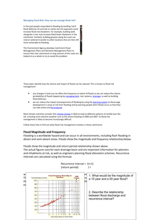
  • 1. Managing Flood Risk: How can we manage flood risk? In the past people responded to flooding by building 'hard' flood defences of concrete or metal, but this approach could increase flood risk elsewhere. For example, building walls alongside a river may increase flood levels elsewhere in the catchment. Similarly, building groynes along the coast can restrict sediment transfer to other locations that are then left more vulnerable to flooding. The Environment Agency develops Catchment Flood Management Plans and Shoreline Management Plans to ensure that river catchments or long sections of the coast are looked at as a whole to try to avoid this problem. These plans identify how the chance and impact of floods can be reduced. This is known as flood risk management: • any changes in land use can affect the frequency or extent of floods so we can reduce the chance (probability) of floods happening by managing land, river systems, drainage, as well as building flood defences. • we can reduce the impact (consequences) of flooding by using the planning system to discourage development in areas at risk from flooding and by warning people when floods occur so that they can take action and be prepared. Most climate scientists consider that climate change is likely to lead to different patterns of rainfall over the UK, including more extreme weather such as the severe flooding of 2000 and 2007. So flood risk management is likely to become increasingly difficult. Follow these links to find out what flood risk management involves in these catchments Flood Magnitude and Frequency Flooding is a worldwide hazard and can occur in all environments, including flash flooding in desert and semi-desert areas. Floods show the magnitude and frequency relationship below: Floods show the magnitude and return period relationship shown above. The actual figures vary for each drainage basin and are important information for planners and inhabitants at risk, as well as engineers planning flood alleviation schemes. Recurrence intervals are calculated using the formula Recurrence Interval = (n+1) (return period) /r where n is the number of discharge levels in the record and r is the rank of that discharge. of 1. What would be the magnitude The data record shows that the flood hazard has increased10 year and a 50decades. Using a over the last few year flood? the return period information, the statistical probability that a magnitude will be equalled or exceeded can be calculated. 2. Describe the relationship between flood discharge and recurrence interval?
  • 2. The Flood hazard Flooding is a regular occurrence in many river systems. Although the magnitude of the flood may vary, floods probably offer more opportunities for people than any other hazard. Flooding maintains soil fertility by depositing fresh layers of alluvium and flushing salt out of soils. The Euphrates, Ganges, Nile Tigris and Yangtze have all supported civilisations as a result of their fertile floodplains. Even today many agricultural systems on floodplains are in harmony with low magnitude high frequency floods. The flood plain has locational advantages alongside water sources, river transport and for waste disposal. Flat floodplain areas are often used for buildings and routeways due to the relative ease of construction. Human habitation of floodplain locations, including higher risk areas increased in the 20th century. This was due to urban development, population pressure, and more road and rail routeways. Thus people have increasingly become exposed to the flood risk and the hazard has increased in relative importance without an actual increase in flood events. In England and Wales less than 2% of the population live on the 1:100 year floodplain. In the USA it is 10% and involves 30 million people. In MEDCs the flood hazard is highest in urban areas. Urban development increases the severity of flooding because of hydrological changes and also the use of storm drains for clearing water. These can quickly become blocked by debris or unable to cope with the volumes of water. In LEDCs floodplains in cities are often the sites of shanty town development. In rural areas agricultural practices are increasingly not suited to flood cycles due to increasing population pressures and the need for cash and food crops. The impacts of a flood are wide ranging. During the event deaths and injury may result from people being swept away by the force of water – people travelling in cars have a particular risk. The damage increases with the velocity of water and the depth of the flood surge. The force of water can damage buildings, with the foundations being damaged by speeds above 3m/s and by debris being swept along. The largest death tolls are recorded in the LEDCs, where high populations may live on the floodplains and deltas with limited flood warning systems. China has the greatest number of people affected by floods, and between 1860 and 1960 5 million Chinese were killed by flooding. In MEDCs the loss of life is reduced but economic losses can be huge.
  • 3. Economic losses do not just include property damage. The impacts can affect national economies in the longer term. Following the July 1997 floods in eastern Europe, the Polish economy suffered the loss of fertile farmland and damage of several billion dollars which resulted in emergency loans from the World Bank to aid recovery. In the Czech Republic , 30% of the country was affected and the costs were estimated at up to $3 billion. Although LEDCs may sustain fewer total economic losses, relatively these may be severe as the economies are less able to contain the losses and recovery is slower. Regional flooding may be followed by increased disease risk from cholera and dysentery as sewage contaminates drinking water and dead animals contaminate the supply. In tropical regions increasing insect numbers may spread diseases such as malaria and yellow fever. Longer term illnesses, especially respiratory diseases, increase, particularly among the old and the young. Impacts on livelihoods can be severe. Labourers are not needed on flooded fields, and it may take years to recover from the loss of possessions and work animals. Vulnerability is highest amongst the poorer members of all societies due to the lower levels of preparedness, economic resilience and health. Poorer people are less likely to be insured. In the UK insurance companies will remove cover unless the national government has maintained adequate defences nationally. The intangible effects of flooding on people’s lives can be dramatic and long term. These impacts often feature more highly economic losses in people’s ratings of concern. How do the intangible effects of flooding compare withy the more tangible impacts of contents damage and structure damage? Case Study: Flood Hazard Perception and response in Malacca, Malaysia
  • 4. The village of Kampung Morten is a traditional Malay settlement within the built-up area of Malacca. The village is situated on the lower reaches of the Malacca River and is frequently flooded, especially during the north-east monsoon season (December-January). The houses show the traditional flooding adjustment of being raised 1.5 to 2 metres above ground on stilts, and villagers also use tyres, sandbags and wooden barricades to reduce flood impacts. Only during larger events are the houses flooded, since water levels must be high enough to rise above the stilts. This occurs quite frequently 1939, 1952, 1954, 1961, 1971, 1985, 2006 etc. Heavy rainfall in the upper Malacca catchment area produces most of the flooding and there is a lag time of about Villagers of Kampung Morten, located next to a river in the Malaysia's southern state of Malacca, wade through their flooded neighbourhood December 22, 2006. Around 50,000 people have been forced to evacuate their flooded homes in southern Malaysia as the region suffered its heaviest rainfall in a century, news reports said on Thursday. Reuters of 18 hours, so there is time for evacuation if warnings are given and residents are responsive to them.
  • 5. The residents were surveyed to understand their perception and response to the flood hazards. How do Kampung Morten residents perceive the flood hazard as threatening their lives? Suggest why the residents accept the flood hazard and continue to live in this location? Only 10% of residents linked flooding to natural processes. Some 70% thought the raopid development of the state had increased the flooding hazard, and, 5% thought the floods were ‘Acts of God’. Their perception of the flood hazard and the degree of anxiety was shown to be important in how they responded to the flood hazard. About 80% of residents wanted a flood warning system and 54% would relocate if they were given enough compensation. This latter figure is relatively low. Nearly half of the residents seem prepared to accept the flood hazard.
  • 6. Use the model above to suggest how the physical factors, dwelling characteristics and personal factors will affect flood hazard perception. Why is the degree of concern important in how residents respond? What actions can residents take if they have a high degree of concern? How can flood risk be managed? In the U.K. The Environment Agency has to manage rivers on behalf of the government and the people who live in the region. It has to balance several responsibilities and meet the needs of a number of interest groups, including • Farmers • Residents of towns and villages on the floodplain • Taxpayers who have to meet the cost of river management, but who might also have to meet the cost of clearing u after floods. • Environmentalists an tourists • Motorists and railway travellers • Business people who have premises on the floodplain • Insurance companies who have to pay some of the costs of clearing up after the floods (shareholders who own part of the insurance company whose dividends may be affected if costs rise). Here are some possible ideas … 1. How would ‘flooding’ rate as a threat compared with other hazards? e.g. drought, (wind) storm, blizzard, extreme temperatures, landslides, fire, traffic. 2. Is River Usk flooding perceived as the main flood risk? Or blocked drains, feeder streams, blocked culverts, sewage spills, overland flow, burst water mains, reservoir burst or canal bank collapse? 3. How would the risk rating for flood risk vary with characteristics like age, sex, previous experience, distance of house from the river? 4. What do people perceive to be their most likely response to a hypothetical warning of an impending flood? 5. What is the level of awareness of different support agencies? 6. Do people know what to do in a flood? Tick a checklist http://www.environment-agency.gov.uk/homeandleisure/floods/38329.aspx
  • 7. www.environment-agency.gov.uk/subjects/flood/826674/830330/882451/ 7. Do people have a ‘flood plan’ in place? Have they done … checklist http://www.environment- agency.gov.uk/subjects/flood/826674/830330/882451/167284/? version=1&lang=_e