Creating Maps of Wakefield Using Local Studies
•
3 gefällt mir•502 views

Rre-introducing the software mapping programme `Local studies' to a Year 5 class.
![Week 5 – Meeting again! ,[object Object],[object Object]](data:image/gif;base64,R0lGODlhAQABAIAAAAAAAP///yH5BAEAAAAALAAAAAABAAEAAAIBRAA7)
Empfohlen
Empfohlen
Weitere ähnliche Inhalte
Ähnlich wie Creating Maps of Wakefield Using Local Studies
Ähnlich wie Creating Maps of Wakefield Using Local Studies (20)
Mehr von Geoprimary
Mehr von Geoprimary (20)
Kürzlich hochgeladen
Kürzlich hochgeladen (20)
Creating Maps of Wakefield Using Local Studies
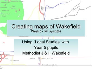
- 1. Creating maps of Wakefield Week 5 - 16 th April 2008 Using `Local Studies’ with Year 5 pupils Methodist J & I, Wakefield
- 3. … and re-visited the Methodist Quikmap http://www.quikmaps.com/full/47961
- 8. Katie’s map is one of the most complex and she lists more places than any of the other children. She has not yet grasped the idea that map convention requires North to be at the top of the map. The relative location of some of these places is muddled. This maps shows the route to Ismael’s house and is a fairly accurate route map. The position or shape of the river is not accurately drawn suggesting that children would benefit from looking at OS maps & Google Earth. Route to the Showcase cinema from school and possibly home
- 9. These maps cover an area close to the school. In the top left example only the locality of the school is shown, whereas the other two maps also include Thornes Park. All of these map-makers use the convention of line to depict routeways and solid squares and rectangles to represent larger spaces, e.g fields and parks. The maps all show North at the top of the page. Using line and space
- 10. Nathan and Tobie are the only pair that chose to represent an area to the south of the school. This area basically shows the route to the Asda supermarket. They have not accurately located Pugneys Lake which is to the west of the supermarket. Lines and space are represented on this map. Interestingly the railway line is shown as a pictorial representation, something that is often done by much younger children.
- 11. I find this to be one of the most interesting of the maps drawn. First because it uses a spatial representation to show the buildings, similar to a large scale OS map and second because it is based on a grid. You could find your way easily using this map. North is at the top The map still uses pictograms (the main featured key in Local Studies). We probably need to moving onto exploring map convention next.
- 12. Finally I have selected these two maps because the children have started by representing areas of land (and water) that have a particular meaning for them, i.e. sporting places and leisure places. Neither of these maps are complete and it seems likely that these four children would go on to add routeways when they complete their maps.