TIMBUKTU_Mali_UNESCO Heritage Site
•Als PPTX, PDF herunterladen•
1 gefällt mir•1,317 views

PPS: http://my.opera.com/bachkien http://chieuquetoi.blogspot.com

Empfohlen
Weitere ähnliche Inhalte
Was ist angesagt?
Was ist angesagt? (20)
Andere mochten auch
Andere mochten auch (20)
Ähnlich wie TIMBUKTU_Mali_UNESCO Heritage Site
Ähnlich wie TIMBUKTU_Mali_UNESCO Heritage Site (20)
Mehr von vinhbinh2010
Mehr von vinhbinh2010 (20)
Kürzlich hochgeladen
Kürzlich hochgeladen (20)
TIMBUKTU_Mali_UNESCO Heritage Site
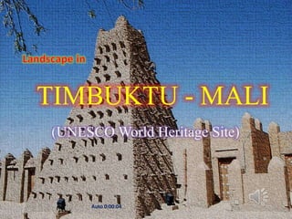
- 1. TIMBUKTU - MALI MALI-Timbuktu (UNESCO World Heritage Site) August 30, 2012 Auto 0:00:04 1
- 2. Auto 0:00:04 August 30, 2012 2
- 3. TIMBUKTU - MALI • Timbuktu (English pronunciation: /ˌ ˌ tɪmbʌkˌtu /; French: Tombouctou pronounced: [ bukˈtu ]; Koyra Chiini: Tumbutu), formerly also spelled Timbuctoo andTimbuktoo, is a town in the West African nation of Mali situated 15 km (9.3 mi) north of the River Niger on the southern edge of the Sahara Desert. The town is the capital of the Timbuktu Region, one of the eight administrative regions of Mali. It had a population of 54,453 in the 2009 census. • Starting out as a seasonal settlement, Timbuktu became a permanent settlement early in the 12th century. After a shift in trading routes, Timbuktu flourished from the trade in salt, gold, ivory and slaves, and it became part of the Mali Empire early in the 13th century. In the first half of the 15th century the Tuaregtribes took control of the city for a short period until the expanding Songhay Empire absorbed the city in 1468. A Moroccan army defeated the Songhay in 1591, and made Timbuktu, rather than Gao, their stronghold. • The invaders established a new ruling class, the arma, who after 1612 became independent of Morocco. However, the golden age of the city was over and it entered a long period of decline. Different tribes governed until the French took over in 1893, a situation that lasted until it became part of the current Republic of Mali in 1960. Presently Timbuktu is impoverished and suffers from desertification. Several initiatives are being undertaken to restore the historic manuscripts still kept in the city. Meanwhile, tourism forms an important source of income. • In its Golden Age, the town's numerous Islamic scholars and extensive trading network made possible an important book trade: together with the campuses of the Sankore Madrasah, an Islamic university, this established Timbuktu as a scholarly centre in Africa. Several notable historic writers, such as Shabeni and Leo Africanus, have described Timbuktu. These stories fuelled speculation in Europe, where the city's reputation shifted from being extremely rich to being mysterious. This reputation overshadows the town itself in modern times, to the point where it is best known in Western culture as an expression for a distant or outlandish place. • On 1 April 2012, one day after the capture of Gao, Timbuktu was captured from the Malian military by the Tuareg rebels of the MNLA and Ansar Dine. Five days later, the MNLA declared the region independent of Mali as the nation of Azawad. The newly declared political entity has not been recognized by any local nations or the international community. (en.wikipedia.org) August 30, 2012 3
- 4. Geography • Timbuktu is located on the southern edge of the Sahara Desert 15 km north of the main channel of the River Niger. The town is surrounded by sand dunes and the streets are covered in sand. The port of Kabara is 8 km to the south of the town and is connected to an arm of the river by a 3 km canal. The canal had become heavily silted but in 2007 it was dredged as part of a Libyan financed project. • The annual flood of the Niger River is a result of the heavy rainfall in the headwaters of the Niger and Bani rivers in Guinea and the northern Ivory Coast. The rainfall in these areas peaks in August but the flood water takes time to pass down the river system and through the Inner Niger Delta. At Koulikoro, 60 km downstream from Bamako, the flood peaks in September, while in Timbuktu the flood lasts longer and usually reaches a maximum at the end of December. • In the past, the area flooded by the river was more extensive and in years with high rainfall, floodwater would reach the western outskirts of Timbuktu itself. A small navigable creek to the west of the town is shown on the maps published by Heinrich Barth in 1857 and Félix Dubois in 1896. Between 1917 and 1921, during the colonial period, the French used forced labour to dig a narrow canal linking Timbuktu with Kabara. Over the following decades this became silted and filled with sand, but in 2007 as part of the dredging project, the canal was re-excavated so that now when the River Niger floods, Timbuktu is again connected to Kabala. The Malian government has promised to address problems with the design of the canal as it currently lacks footbridges and the steep unstable banks make access to the water difficult. • Kabara can only function as a port in December to January when the river is in full flood. When the water levels are lower, boats dock at Korioumé which is linked to Timbuktu by 18 km of paved road (en.wikipedia.org) August 30, 2012 4
- 5. World Heritage Site • During its twelfth session, in December 1988, the World Heritage Committee (WHC) selected parts of Timbuktu's historic centre for inscription on its World Heritage list. The selection was based on three criteria: • Criterion II: Timbuktu's holy places were vital to early Islamization in Africa. • Criterion IV: Timbuktu's mosques show a cultural and scholarly Golden Age during the Songhay Empire. • Criterion V: The construction of the mosques, still mostly original, shows the use of traditional building techniques. • An earlier nomination in 1979 failed the following year as it lacked proper demarcation: the Malian government included the town of Timbuktu as a whole in the wish for inclusion. [131] Close to a decade later, three mosques and 16 mausoleums or cemeteries were selected from the Old Town for World Heritage status: with this conclusion came the call for protection of the buildings' conditions, an exclusion of new construction works near the sites and measures against theencroaching sand. • Shortly afterwards, the monuments were placed on the List of World Heritage in Danger by the Malian government, as suggested by the selection committee at the time of nomination. The first period on the Danger List lasted from 1990 until 2005, when a range of measures including restoration work and the compilation of an inventory warranted "its removal from the Danger List". In 2008 the WHC placed the protected area under increased scrutiny dubbed 'reinforced monitoring', a measure made possible in 2007, as the impact of planned construction work was unclear. Special attention was given to the build of a cultural centre. • During a session in June 2009, UNESCO decided to cease its increased monitoring program as it felt sufficient progress had been made to address the initial concerns. Following the takeover of Timbuktu by MNLA and the Islamist group Ansar Dine, it was returned to the List of World Heritage in Danger in 2012. 30, 2012 August (en.wikipedia.org) 5
- 6. Caillie 1830_Timbuktu_view August 30, 2012 6 Dubois_1896_Timbuktu_plan
- 7. • Timbuktu (tiếng Anh cổ: Timbuctoo; tiếng Koyra Chiini: Tumbutu; tiếng Pháp: Tombouctou) là một thành phố cổ ở vùng Tombouctou, MALI. Đây là quê hương của Đại học Sankore và các madrasa (các trường tôn giáo) khác, nơi đây cũng từng là thủ đô tinh thần và tri thức và một trung tâm Hồi giáo nơi truyền bá tôn giáo này ra khắp châu Phi trong các thế kỷ 15 và 16. Ba giáo đường lớn tại đây, Giáo đường Djinguereber, Sankore và Sidi Yahya, gợi lại về thời hoàng kim của Timbuktu. Tuy liên tục được trùng tu, nhưng ngày nay các di tích này đang chịu nguy cơ bị sa mạc hóa. (vi.wikipedia.org) August 30, 2012 7
- 8. SANKORE MOSQUE August 30, 2012 8
- 9. August 30, 2012 9
- 10. August 30, 2012 10
- 11. August 30, 2012 11
- 12. August 30, 2012 12
- 13. August 30, 2012 13
- 15. August 30, 2012 15
- 16. August 30, 2012 16
- 17. August 30, 2012 17
- 18. August 30, 2012 18
- 19. August 30, 2012 19
- 20. August 30, 2012 20
- 21. August 30, 2012 21
- 22. August 30, 2012 22
- 23. August 30, 2012 23
- 24. August 30, 2012 24
- 25. August 30, 2012 25
- 26. August 30, 2012 26
- 27. August 30, 2012 27
- 28. August 30, 2012 28
- 29. August 30, 2012 29
- 30. August 30, 2012 30
- 31. August 30, 2012 31
- 32. August 30, 2012 32
- 33. August 30, 2012 33
- 34. August 30, 2012 34
- 35. August 30, 2012 35
- 36. August 30, 2012 36
- 37. The Niger River near Timbuktu, Mali August 30, 2012 37
- 38. August 30, 2012 38
- 39. August 30, 2012 39
- 40. August 30, 2012 40
- 41. August 30, 2012 41
- 42. August 30, 2012 42
- 43. August 30, 2012 43
- 44. August 30, 2012 44
- 45. August 30, 2012 45
- 46. August 30, 2012 46
- 47. August 30, 2012 47
- 48. August 30, 2012 48
- 49. August 30, 2012 49
- 50. August 30, 2012 50
- 51. August 30, 2012 51
- 52. August 30, 2012 52
- 53. August 30, 2012 53
- 54. August 30, 2012 54
- 55. August 30, 2012 55
- 56. August 30, 2012 56
- 57. August 30, 2012 57
- 58. August 30, 2012 58
- 59. August 30, 2012 59
- 60. August 30, 2012 60
- 61. August 30, 2012 61
- 62. August 30, 2012 62
- 63. August 30, 2012 63
- 64. August 30, 2012 64
- 65. August 30, 2012 65
- 66. August 30, 2012 66
- 67. August 30, 2012 67
- 68. August 30, 2012 68
- 69. August 30, 2012 69
- 70. August 30, 2012 70
- 71. August 30, 2012 71
- 72. August 30, 2012 72
- 73. August 30, 2012 73
- 74. August 30, 2012 74
- 75. August 30, 2012 75
- 76. August 30, 2012 76
- 77. August 30, 2012 77
- 78. August 30, 2012 78
- 79. August 30, 2012 79
- 80. August 30, 2012 80
- 81. August 30, 2012 81
- 82. August 30, 2012 82
- 83. August 30, 2012 83
- 84. August 30, 2012 84
- 85. August 30, 2012 85
- 86. August 30, 2012 86
- 87. August 30, 2012 87
- 88. August 30, 2012 88
- 89. August 30, 2012 89
- 90. Biên tập : http://my.opera.com/bachkien http://chieuquetoi.blogspot.com August 30, 2012 90