Partnerships to support conservation with organic producers
Farone_Portfolio_poster_final
1. Setting Goals and Priorities for Biodiversity Conservation
Ecoregional Portfolio Core Dataset
Ecoregional assessments are the result of rigorous
scientific analyses, and provide a regional scale,
biodiversity-based context for implementing
conservation efforts. They identify ecologically
significant areas for conservation actions with the goal
of protecting representative biodiversity.
These conservation actions may be any of a range of
strategies, including: incentives for private landowners,
acknowledging and encouraging best management practices
on working landscapes, restoring degraded ecosystems, and
putting land in conservation easements.
The map products of ecoregional assessments are
ecoregional portfolios. These portfolios of prioritized sites
for conservation illustrate the places and elements of
biodiversity that represent the Conservancy’s vision of
conservation success.
When The Nature Conservancy adopted its “Conservation
by Design” methods and undertook the development of
ecoregional assessments, it was envisioned that the
ecoregional portfolios would ultimately be rolled up into a
“blueprint for conservation” in the U.S. and beyond that would
then be usable by the Conservancy and by many other
interests to inform conservation priorities. This vision is being
realized realized in the Ecoregional Portfolio Core
Dataset.
The Ecoregional Portfolio Core Data Set will enable the
Conservancy to communicate the vision of Conservation by
Design, help influence the strategies of our many partners in
conservation, and catalyze new conservation efforts.
This work responds to TNC's commitment to work with
others to conserve 10% of the world's biodiversity.
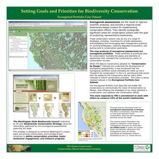
The Washington State Biodiversity Council undertook
at 30-year Biodiversity Conservation Strategy using the
information gathered by nine ecoregional assessments
spanning the state.
The strategy is designed to conserve Washington’s unique
plant and animal communities, and includes broad
initiatives to define conservation priorities, foster
landowner engagement, and measure progress.
Through sharing information from six
ecoregional assessments in Arizona,
The Nature Conservancy has been able
to help guide decisions about
conservation, land-use and management
activities across the state.
This science-based information has
helped to influence a wide range of
management decisions on more than
six million acres of public and private
lands, and became influential in the
management plans for forests,
grasslands and headwater streams
stewarded by the U.S. Forest Service.
The Nature Conservancy
Conservation Data & Information Systems