Presentation on how to chat with PDF using ChatGPT code interpreter
NIRPC 2040 Plan & Livable Centers Initiative Agenda
1. 7/9/2014
1
Steve Strains
Deputy Director/Director of Planning
Gabrielle Biciunas
Long Range Planner
Kathy Luther
Director of Environmental Programs
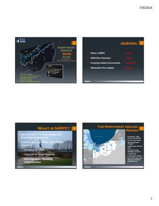
AGENDA
• What is NIRPC Steve
• 2040 Plan Overview Steve
• Creating Livable Communities Gabrielle
• Marquette Plan Update Kathy
• Northwestern Indiana Regional
Planning Commission
• Covers Lake, La Porte, and Porter
Counties
Created in 1965
Council of Governments
Metropolitan Planning
Organization
What is NIRPC?
The Northwest Indiana
Region
• 3 counties: Lake,
Porter, and LaPorte
• 41 cities and towns
• 2010 population:
771,815
• 1,520 square miles of
land
• 45 miles of Lake
Michigan shoreline
• 4 Interstates
• 1 commuter rail line
• Part of the 16 county
Chicago combined
statistical area
2. 7/9/2014
2
NIRPC 2040 Comprehensive
Regional Plan
A Vision for
Northwest Indiana
• The 2040 Plan is built on a “community‐
based regional consensus” ‐ the outcome
of numerous public involvement meetings
with residents and decision makers.
• Overall direction was conceived at the
Forum on the Future of Northwest
Indiana, a 500‐person visioning event held
in December 2008.
INVision Northwest Indiana - Stretching from the treasured shores
of Lake Michigan to the historic banks of the Kankakee River and
committed to an ethic of sustainability:
A Vibrant Region
Our economy is thriving; our people are well-educated; our
growth is planned; and natural and rural areas are valued
and protected.
A Vibrant Region
Our economy is thriving; our people are well-educated; our
growth is planned; and natural and rural areas are valued
and protected.
A Revitalized Region
Urban areas are renewed, and our environment is clean.
An Accessible Region
Our people are connected to each other and to equal
opportunities for working, playing, living and learning.
An Accessible Region
Our people are connected to each other and to equal
opportunities for working, playing, living and learning.
A United Region
Celebrating our diversity, we work together as a community
across racial, ethnic, political and cultural lines for the good
of the region.
A United Region
Celebrating our diversity, we work together as a community
across racial, ethnic, political and cultural lines for the good
of the region.
7
SUPPORT URBAN REINVESTMENT
ENSURE ENVIRONMENTAL JUSTICE
PROTECT NATURAL RESOURCES AND MINIMIZE IMPACTS TO
ENVIRONMENTAL FEATURES AND WATERSHEDS
INTEGRATE TRANSPORTATION AND LAND USE
• Strengthen the urban core
• Preserve the cultural and historic assets of Northwest Indiana
• Avoid or reduce adverse consequences
• Improve mobility and access to jobs
• Conserve the green infrastructure that supports native species
• Maintain natural ecological processes, protects air and water
resources
• Contribute to the health and resiliency of the region.
• Develop a multimodal system, including enhanced public mass
transit and non-motorized transportation to improve mobility,
access to jobs and improved quality of life for all.
THE PRINCIPLES
3. 7/9/2014
3
SUPPORT URBAN REINVESTMENT
ENSURE ENVIRONMENTAL JUSTICE
PROTECT NATURAL RESOURCES AND MINIMIZE IMPACTS TO
ENVIRONMENTAL FEATURES AND WATERSHEDS
INTEGRATE TRANSPORTATION AND LAND USE
• Strengthen the urban core
• Preserve the cultural and historic assets of Northwest Indiana
• Avoid or reduce adverse consequences
• Improve mobility and access to jobs
• Conserve the green infrastructure that supports native species
• Maintain natural ecological processes, protect air and water
resources
• Contribute to the health and resiliency of the region.
• Develop a multimodal system, including enhanced public mass
transit and non-motorized transportation to improve mobility,
access to jobs and improved quality of life for all.
THE PRINCIPLES
4. 7/9/2014
4
SUPPORT URBAN REINVESTMENT
ENSURE ENVIRONMENTAL JUSTICE
PROTECT NATURAL RESOURCES AND MINIMIZE IMPACTS TO
ENVIRONMENTAL FEATURES AND WATERSHEDS
INTEGRATE TRANSPORTATION AND LAND USE
• Strengthen the urban core
• Preserve the cultural and historic assets of Northwest Indiana
• Avoid or reduce adverse consequences
• Improve mobility and access to jobs
• Conserve the green infrastructure that supports native species
• Maintain natural ecological processes, protect air and water
resources
• Contribute to the health and resiliency of the region.
• Develop a multimodal system, including enhanced public mass
transit and non-motorized transportation to improve mobility,
access to jobs and improved quality of life for all.
THE PRINCIPLES
Ecological Assets
Managed Lands
Priority Forests
Biodiversity
Hydric Soils
Water Resources
Wetlands
Streams and Lakes
Floodplains
Vulnerable
Groundwater
SUPPORT URBAN REINVESTMENT
ENSURE ENVIRONMENTAL JUSTICE
PROTECT NATURAL RESOURCES AND MINIMIZE IMPACTS TO
ENVIRONMENTAL FEATURES AND WATERSHEDS
INTEGRATE TRANSPORTATION AND LAND USE
• Strengthen the urban core
• Preserve the cultural and historic assets of Northwest Indiana
• Avoid or reduce adverse consequences
• Improve mobility and access to jobs
• Conserve the green infrastructure that supports native species
• Maintain natural ecological processes, protect air and water
resources
• Contribute to the health and resiliency of the region.
• Develop a multimodal system, including enhanced public mass
transit and non-motorized transportation to improve mobility,
access to jobs and improved quality of life for all.
THE PRINCIPLES
5. 7/9/2014
5
NIRPC 2040 Comprehensive
Regional Plan
The CRP stresses a number of
elements that include:
• Growth & Conservation
• Transportation
• Environment & Green
Infrastructure
• Human & Economic Resources
• Stewardship & Governance
18
The NWI region is expected to add 170,000 people and 80,000 new jobs by
2040
Accommodating this growth will
Overburden the region’s transportation network
Increase development pressure on the region’s natural lands, farmland and forest lands.
Vacant land already exists in urbanized areas of existing communities.
However, the development trend has been shifting away from the more
historically urban portions of the region and into unincorporated areas.
Existing land supply meets the growth needs and demands through 2040.
New strategies to address this growth
2040 Plan Findings
Presented By:
Long Range Planner
Lake & Porter Counties
6. 7/9/2014
6
• To encourage livability and accessibility, NIRPC has called for
transit-oriented development and Livable Centers Initiative in
the 2040 Plan.
• Livable Centers Initiative is one of the principal urban
framework strategies for the 2040 Comprehensive Regional
Plan, which is fundamental to achieve the preferred regional
strategy for land use, transportation and environmental
balance in Northwest Indiana.
Livable Centers Initiative (LCI)
Creating Livable Communities (CLC) Funding Program
Livable Centers clustering many different
land uses in a compact area gives people
the opportunity to accomplish various
activities without using a car.
• Livable Centers make it easy to
reach multiple destinations by foot,
bicycle, car or transit.
• A well-designed street and sidewalk
system provides good connectivity
and safety for everyone.
• Livable Centers concentrate housing,
employment, shopping, and
entertainment in areas with good
pedestrian networks
Poor Connectivity
Good Connectivity
7. 7/9/2014
7
• Compact, mixed use development- building facing
streets
• Short block length (400’-600’)
• Having unique and distinct design characteristic
with shops offer local products and services
• Many Access options including pedestrian lanes,
bike lanes, trails, transit, and roadways
• Convenient, safe and easy street crossing
• Well-maintained public streets
• Public gathering places
• Serving different activities that occurred both
daytime and night time
• Jobs and housing
• On-street, shared, structured or rear parking areas
• Transit stops and amenities
• Traditional street grid
• Access management
• Pedestrian-friendly speed limits
• Short block lengths
• Bicycle lanes
• Wide sidewalks
• Public spaces
• Minimal building setbacks
• Existing infrastructure
• Analyze region as a whole
• Block Size
• Street Grid
• Population, housing, and employment density
• Proximity of schools, civic halls, transit, and trails
• Read the municipality’s plans and past projects
• Learned about current projects and initiatives
• Met with individual municipality planners and other staff
• Listened to their plans, hopes, and considerations for their town or
city
• Drew boundaries directly on the maps using their insight and
NIRPC’s analysis
8. 7/9/2014
8
How to Use the Report?
• Use the Introduction
section to get yourself
familiar with:
• Livable Centers
definition and
benefits.
• How center are
defined
• Livability checklist
• NIRPC Methodology
• Find your Community
Transit-Related Projects should
be located within half a mile
from a transit stop or station.
9. 7/9/2014
9
NIRPC/Walk Score
Methodologies
Walk
Score® Description
90–100
Walker's Paradise
Daily errands do not
require a car.
70–89
Very Walkable
Most errands can be
accomplished on foot.
50–69
Somewhat Walkable
Some errands can be
accomplished on foot.
25–49
Car-Dependent
Most errands require a car.
0–24
Car-Dependent
Almost all errands require
a car.
Walk Score Analysis:
• Walking routes to nearby
amenities.
• Points are awarded based
on the distance to
amenities
• Amenities within a 5
minute walk (.25 miles) are
given maximum points.
• The more distant amenities
the more decline in score
with no points given after a
30 minute walk.
• Pedestrian friendliness is
measured by analyzing
• population density
• road metrics such as block
length and intersection
density http://www.walkscore.com/
NIRPC Analysis
• Block Length (400’-600’)
• Street Grid/Connectivity
• Population, housing, and
employment density
• Proximity of schools, civic
halls, transit, and trails
• Transit
• Mixed use
• Building Setback
Creating Livable Communities (CLC)
Funding Program
10. 7/9/2014
10
The purpose of this funding is to support community-based
transportation/ land use projects that bring vitality to downtown
areas, neighborhoods, station areas, commercial cores, and
transit corridors.
Putting real transportation dollars behind its
planning efforts, NIRPC developed the new
funding program to help ensure that
transportation investments will be linked to
the vitality of northwestern Indiana’s
communities.
$400,000 over the next two years has been
identified to provide tangible support to
communities in Lake & Porter Counties
seeking to enhance their center places, with
some prime beneficiaries being those
communities able to take advantage of also
TOD opportunities.
Overview:
To support community-based transportation/ land use projects
that bring vitality to downtown areas, neighborhoods, station
areas, commercial cores, and transit corridors.
To support projects that are guided by the principle of
“place-making”
Requirements / Eligibility:
Local Governments and non-profit organizations
Projects should be located in the Livable Centers Map or
Transit Area Map.
Types of Grants:
Fund planning projects or pre-development plan that
revitalize: existing centers, neighborhood, downtown,
transit stop or transit corridors, TOD ordinance, and/or
Prepare projects to compete for grants in the Capital
Projects category.
• NIRPC has awarded seven grants totaling $402,500 of STP
funding to seven communities. The total funding with the
local match is $495,500. These communities are:
• Chesterton
• Crown Point
• East Chicago
• Gary
• Highland
• Porter
• Winfield
11. 7/9/2014
11
Comprehensive vision for
the Lake Michigan
Shoreline
Livable Lakefront- Live
Work Play
Recapture 75 percent of the
lakeshore for public use;
Establish a minimum
setback from water’s edge
of 200 feet;
Create a continuous trail
network through northwest
Indiana
Marquette Plan Goals
Marquette Greenway = 51.2
Continuous Miles state line to
state line.
Marquette Plan Vision Area
Maintained and Implemented by a collaboration of the NWI RDA, NIRPC,
and DNR Lake Michigan Coastal Program (LMCP) as well as local
communities.
The Update
12. 7/9/2014
12
Integrate The Plan
Consolidated Frameworks from Phase I and Phase
II in draft
Transportation and Infrastructure Improvements
Public Access, Recreation, and Tourism
Green Infrastructure and Environmental Protection
Livable Communities
Land Revitalization and Economic Development
Community Coordination
Culture and History New Framework!
Public Access Overview
Public Access Overview
Goal: 75% of Lakeshore with Public Access
= 33.8 miles – need to gain 9.5
What Is Public Access?
See it
Walk it
Swim it
Boat it
Fish it
Not all places can be all things to all people!
Lake Michigan Access State Line Energy
Miles Percent
Total 45 100.00%
accessible now 24.2 53.78%
w/ whole stateline 25.05 55.67%
w/ half stateline 24.7 54.89%
w/ partial stateline 24.5 54.44%
Stateline Marquette Trail
Miles
Giant Loop 1.4
Trail with spur on western side 1
Trail w/ no spur 0.5
Marquette Greenway
Trail from Illinois to Michigan State Line
Total Network 51.2 miles
16.9 miles built = 34.3%
14 additional miles funded in the next 2‐3 years.
13. 7/9/2014
13
Cultural and Historical Assets
CULTURE AND HISTORY
GENERAL POLICY RECOMMENDATIONS
1. Historic Preservation Planning
2. Federal Historic Designation
3. Historic Resource Rehabilitation
4. Economic Development Incentives
5. Development and Design Standards
6. Comprehensive, Master and Subarea Development Plans
7. Public-Private Partnerships
8. Environmental & Sustainability Principles
9. Arts and Culture Districts
10.Heritage Tourism
Marquette Sub Area Realignment
Hammond
Whiting
East Chicago
Gary West
Gary Downtown/East
Portage/Ogden Dunes
Duneland
Michigan City
LaPorte County North Shore
Each Update to include:
Sub Area Vision
Projects Completed & In Progress
Funding Investments
Future Plans and Changes
Marquette Successes
Challenges
Hammond Sub Area Maps
All Sub Area plan pages are in draft format for
local review and vetting
14. 7/9/2014
14
Whiting Sub Area Maps
All Sub Area plan pages are in draft format for
local review and vetting
East Chicago Sub‐Area Maps
All Sub Area plan pages are in draft format for
local review and vetting
Gary West Sub‐Area Maps
All Sub Area plan pages are in draft format for local review and vetting
Gary East Sub Area Maps
Sub Area plan pages are currently being assembled for local review and vetting
15. 7/9/2014
15
LaPorte Sub‐Area Maps
Sub Area plan pages are currently
being assembled for local review and
vetting
Next Steps
Complete Porter County Sub‐Area mapping
Additional Green Infrastructure mapping
Editing Framework and Subareas text and desk‐top
publishing
Vetting maps with cities and lakeshore property
owners
Additional Public Open Houses
Work with RDA to build website
Thank you to:
RDA
Indiana Lake Michigan Coastal Program
Tiffany Tolbert, Indiana Landmarks
Eman Ibrahim, Jack Eskin, Sarah Geinosky – NIRPC
Staff
www.NIRPC.org
Contact Information
Kathy Luther
Director of Environmental
Programs
kluther@nirpc.org
Gabrielle Biciunas
Long Range Planner
gbiciunas@nirpc.org
Steve Strains
Deputy Director/
Director of Planning
sstrains@nirpc.org
6100 Southport Road
Portage IN 46368
Phone: 219‐763‐6060