Geography Of Canada Study Guide
•Download as DOC, PDF•
1 like•993 views

This study guide provides instructions for students to label key political and physical features of Canada on two maps. It includes a list of provinces and territories to label on the first map and physical features like oceans, rivers, and mountain ranges to label on the second map. It also includes short answer questions to test the students' understanding of topics covered in class, such as the Canadian Shield, population distribution, environmental concerns, and political divisions.

Recommended
More Related Content
Similar to Geography Of Canada Study Guide
More from Long Cane Middle School
More from Long Cane Middle School (12)
Recently uploaded
Recently uploaded (20)
Geography Of Canada Study Guide
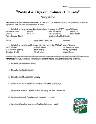
- 1. Name: _______________________ “Political & Physical Features of Canada” Study Guide Part One: Use the map of Canada ON THE BACK OF THIS PAPER to label the provinces, territories, & physical features that we’ve studied in class. 1. Label all of the provinces & territories listed below on the FIRST map of Canada. British Columbia Alberta Saskatchewan Manitoba Ontario Quebec New Brunswick Nova Scotia Prince Edward Island Newfoundland & Labrador Yukon Northwest Territories Nunavut 2. Label all of the physical features listed below on the SECOND map of Canada: Pacific Ocean Atlantic Ocean St. Lawrence River St. Lawrence Seaway Hudson Bay Rocky Mountains Canadian Shield Great Lakes Arctic Ocean ~~~~~~~~~~~~~~~~~~~~~~~~~~~~~~~~~~~~~~~~~~~~~~~~~~~~~~~~~~~~~ Part Two: Use your Physical Features of Canada Notes to answer the following questions. 3. Describe the Canadian Shield: 4. Describe the Pacific Ocean: 5. Describe the St. Lawrence Seaway: 6. Where does the majority of Canada’s population live? Why? 7. What are Canada’s 3 Prairie Provinces? Why are they called this? 8. What are three of Canada’s environmental concerns? 9. What are Canada’s two types of political divisions called?