SlideShare ist ein Scribd-Unternehmen logo
1 von 10
Downloaden Sie, um offline zu lesen
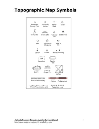
Topographic Map Symbols


Natural Resources Canada: Mapping Services Branch   1
http://maps.nrcan.gc.ca/topo101/symbols_e.php
Natural Resources Canada: Mapping Services Branch   2
http://maps.nrcan.gc.ca/topo101/symbols_e.php
Topographic Map Symbols - Roads and Trails

                         Feature Name                            Symbol
                   Road - hard surface, all season-4 Lanes
                                    (two way road, divided)
                   Road - hard surface, all season- 2 Lanes

                                         Less than 2 Lanes
      Road - loose or stabilized surface, all season-2 Lanes
                                          Less than 2 Lanes

                         Road - loose surface, dry weather

                                   Rapid transit route, road

                                  Road under construction
                  (width and colour vary with classification)

                                Vehicle track or winter road

                                            Trail or portage

                                                Traffic circle

                                     Highway route number


Natural Resources Canada: Mapping Services Branch                         3
http://maps.nrcan.gc.ca/topo101/symbols_e.php
Topographic Map Symbols - Railways and Airports
                        Feature Name                  Symbol

                         Railway - multiple track

                           Railway - single track

                                 Railway sidings

                           Railway - rapid transit

                    Railway - under construction

                            Railway - abandoned

                                 Railway on road

                                  Railway station

                                 Airfield; Heliport

                    Airfield, position approximate

                Airfield runways; paved, unpaved


Natural Resources Canada: Mapping Services Branch              4
http://maps.nrcan.gc.ca/topo101/symbols_e.php
Topographic Map Symbols - Other Transportation Features
                            Feature Name                  Symbol

                          Tunnel; railway, road

                                          Bridge

                        Bridge; swing, draw, lift

                                     Footbridge

                                      Causeway

                                            Ford

                                             Cut

                                   Embankment

                                     Snow shed

                                 Barrier or gate


               Topographic Map Symbols - Recreation
                          (Feature Name                            Symbol

                                                Sports track

                                             Swimming pool

                                                    Stadium

                                                 Golf course

                                          Golf driving range

                                  Campground; Picnic site

                                          Ski area, ski jump

                                      Rifle range with butts

          Historic site or point of interest; Navigation light

                                    Aerial cableway, ski lift


Natural Resources Canada: Mapping Services Branch                           5
http://maps.nrcan.gc.ca/topo101/symbols_e.php
Topographic Map Symbols - Agriculture and Industry
                          Feature Name                            Symbol

                                                          Silo

                                                     Elevator

                                                 Greenhouse

                                Wind-operated device; Mine

         Landmark object (with height); tower, chimney, etc.

                                    Oil or natural gas facility


                   Pipeline, multiple pipelines, control valve

                                      Pipeline, underground
                            multiple pipelines, underground

                                              Electric facility

                                    Power transmission line
                                              multiple lines

                                              Telephone line

                                                       Fence

                              Crane, vertical and horizontal

                                               Dyke or levee

                                                    Firebreak

                                                      Cut line


Natural Resources Canada: Mapping Services Branch                          6
http://maps.nrcan.gc.ca/topo101/symbols_e.php
Topographic Map Symbols - Buildings
                           Feature Name                         Symbol

                        School; Fire station; Police station

           Church; Non-Christian place of worship; Shrine

                                                   Building

                                            Service centre

                                             Customs post

                                      Coast Guard station

                                                 Cemetary

                                                     Ruins

                                                       Fort


                 Topographic Map Symbols - Elevation
                           Feature Name                          Symbol

          Horizontal control point; Bench mark with elevation

                                           Precise elevation


                               Contours; index, intermediate


                                        Depression contours


Natural Resources Canada: Mapping Services Branch                         7
http://maps.nrcan.gc.ca/topo101/symbols_e.php
Topographic Map Symbols - Geology and Geomorphology
                        Feature Name         Symbol

                      Cliff or escarpment

                                   Esker

                                   Pingo

                                   Sand

                                Moraine


                                  Quarry


                                   Cave


              Topographic Map Symbols - Land Cover
                        Feature Name        Symbol


                         Wooded area


                              Orchard


                              Vineyard


Natural Resources Canada: Mapping Services Branch        8
http://maps.nrcan.gc.ca/topo101/symbols_e.php
Topographic Map Symbols - Hydrographic Features (Man Made)
                       Feature Name                   Symbol

                                              Lock

                                Dam; large, small

                               Dam carrying road

                                       Footbridge


                                      Ferry Route


                             Pier; Wharf; Seawall

                                       Breakwater

                        Slip; Boat ramp; Drydock

                     Canal; navigable or irrigation

                               Canal, abandoned

                             Shipwreak, exposed

                    Crib or abandoned bridge pier

                                 Submarine cable


              Seaplane anchorage; Seaplane base


Natural Resources Canada: Mapping Services Branch              9
http://maps.nrcan.gc.ca/topo101/symbols_e.php
Topographic Map Symbols - Hydrographic Features (Naturally
                       Occurring)
                        Feature Name                Symbol

                                            Falls

                                         Rapids

                          Direction of flow arrow

                                    Dry river bed

                            Stream - intermittent

                Sand in Water or Foreshore Flats

                               Rocky ledge, reef

                                   Flooded area

                                 Marsh, muskeg

                                         Swamp

                     Well, water or brine; Spring

                  Rocks in water or small islands

                                 Water elevation


Natural Resources Canada: Mapping Services Branch            10
http://maps.nrcan.gc.ca/topo101/symbols_e.php

Weitere ähnliche Inhalte

Was ist angesagt?

Introduction and Application of GIS
Introduction and Application of GISIntroduction and Application of GIS
Introduction and Application of GISSatish Taji
 
Basic of gis concept and theories
Basic of gis concept and theoriesBasic of gis concept and theories
Basic of gis concept and theoriesMohsin Siddique
 
Geo referencing by Mashhood Arif
Geo referencing by Mashhood ArifGeo referencing by Mashhood Arif
Geo referencing by Mashhood ArifKU Leuven
 
Remote sensing in Civil Engineering
Remote sensing in Civil EngineeringRemote sensing in Civil Engineering
Remote sensing in Civil EngineeringManishkumar Dubey
 
Remote Sensing Platforms and Sensors
Remote Sensing Platforms and SensorsRemote Sensing Platforms and Sensors
Remote Sensing Platforms and SensorsUday kumar Devalla
 
Numbering system of topographical map
Numbering system of topographical mapNumbering system of topographical map
Numbering system of topographical mapMithun Ray
 
Geographical Information System (GIS) Georeferencing and Digitization, Bihar ...
Geographical Information System (GIS) Georeferencing and Digitization, Bihar ...Geographical Information System (GIS) Georeferencing and Digitization, Bihar ...
Geographical Information System (GIS) Georeferencing and Digitization, Bihar ...Kamlesh Kumar
 
Emr intraction with atmosphere
Emr intraction with atmosphereEmr intraction with atmosphere
Emr intraction with atmosphereRahat Hasan
 
Applications of gis
Applications of gisApplications of gis
Applications of gisPramoda Raj
 
Geometry of Aerial photograph
Geometry of Aerial photographGeometry of Aerial photograph
Geometry of Aerial photographApoorva Mathur
 
Geo synchronous and Sun synchronous Satellites
Geo synchronous and Sun synchronous SatellitesGeo synchronous and Sun synchronous Satellites
Geo synchronous and Sun synchronous SatellitesTilok Chetri
 
Thermal Remote Sensing
Thermal Remote SensingThermal Remote Sensing
Thermal Remote SensingRohit Kumar
 
Digitization in ArcGIS
Digitization in ArcGISDigitization in ArcGIS
Digitization in ArcGISKU Leuven
 
Band ratioing presentation
Band ratioing presentationBand ratioing presentation
Band ratioing presentationsk asadul haque
 
Vector data model
Vector data modelVector data model
Vector data modelPramoda Raj
 

Was ist angesagt? (20)

Introduction and Application of GIS
Introduction and Application of GISIntroduction and Application of GIS
Introduction and Application of GIS
 
Basic of gis concept and theories
Basic of gis concept and theoriesBasic of gis concept and theories
Basic of gis concept and theories
 
Geo referencing by Mashhood Arif
Geo referencing by Mashhood ArifGeo referencing by Mashhood Arif
Geo referencing by Mashhood Arif
 
Pre processing
Pre processingPre processing
Pre processing
 
Remote sensing in Civil Engineering
Remote sensing in Civil EngineeringRemote sensing in Civil Engineering
Remote sensing in Civil Engineering
 
Remote Sensing Platforms and Sensors
Remote Sensing Platforms and SensorsRemote Sensing Platforms and Sensors
Remote Sensing Platforms and Sensors
 
Gis unit 3
Gis   unit 3Gis   unit 3
Gis unit 3
 
Numbering system of topographical map
Numbering system of topographical mapNumbering system of topographical map
Numbering system of topographical map
 
Map projection
Map projection Map projection
Map projection
 
Geographical Information System (GIS) Georeferencing and Digitization, Bihar ...
Geographical Information System (GIS) Georeferencing and Digitization, Bihar ...Geographical Information System (GIS) Georeferencing and Digitization, Bihar ...
Geographical Information System (GIS) Georeferencing and Digitization, Bihar ...
 
ERDAS IMAGINE
ERDAS IMAGINEERDAS IMAGINE
ERDAS IMAGINE
 
Emr intraction with atmosphere
Emr intraction with atmosphereEmr intraction with atmosphere
Emr intraction with atmosphere
 
Applications of gis
Applications of gisApplications of gis
Applications of gis
 
Remote sensing
Remote sensingRemote sensing
Remote sensing
 
Geometry of Aerial photograph
Geometry of Aerial photographGeometry of Aerial photograph
Geometry of Aerial photograph
 
Geo synchronous and Sun synchronous Satellites
Geo synchronous and Sun synchronous SatellitesGeo synchronous and Sun synchronous Satellites
Geo synchronous and Sun synchronous Satellites
 
Thermal Remote Sensing
Thermal Remote SensingThermal Remote Sensing
Thermal Remote Sensing
 
Digitization in ArcGIS
Digitization in ArcGISDigitization in ArcGIS
Digitization in ArcGIS
 
Band ratioing presentation
Band ratioing presentationBand ratioing presentation
Band ratioing presentation
 
Vector data model
Vector data modelVector data model
Vector data model
 

Andere mochten auch

Secondary 1 Geography-Topographic Map
Secondary 1 Geography-Topographic MapSecondary 1 Geography-Topographic Map
Secondary 1 Geography-Topographic MapMarioSonic54
 
Topographic maps for UDL lesson
Topographic maps for UDL lessonTopographic maps for UDL lesson
Topographic maps for UDL lessonrbritton24
 
Basic topographic mapping
Basic topographic mappingBasic topographic mapping
Basic topographic mappingBhok Millare
 
Contour Line and Creating Emphasis with Color
Contour Line and Creating Emphasis with ColorContour Line and Creating Emphasis with Color
Contour Line and Creating Emphasis with ColorLaura Johnson
 
Reading a topographic map
Reading a topographic mapReading a topographic map
Reading a topographic mapRachael Hubbard
 
Kp 07 2010 standar penggambaran
Kp 07 2010 standar penggambaranKp 07 2010 standar penggambaran
Kp 07 2010 standar penggambaranArizki_Hidayat
 
Class X ICSE Geography Solved Question Paper
Class X ICSE Geography Solved Question PaperClass X ICSE Geography Solved Question Paper
Class X ICSE Geography Solved Question PaperAtrayee SenGupta
 
Topographic maps presentation_mine
Topographic maps presentation_mineTopographic maps presentation_mine
Topographic maps presentation_minemisterbatroms
 
SITE ANALYSIS - TOPOGRAPHY
SITE ANALYSIS - TOPOGRAPHYSITE ANALYSIS - TOPOGRAPHY
SITE ANALYSIS - TOPOGRAPHYYeeQun
 
Cornea Topography
Cornea TopographyCornea Topography
Cornea Topographyeyeguru
 
Line Drawing Techniques
Line Drawing TechniquesLine Drawing Techniques
Line Drawing TechniquesFrank Curkovic
 
Site planning kevin lynch
Site planning kevin lynchSite planning kevin lynch
Site planning kevin lynchXtian Escala
 
Case study/ Literature of a School
Case study/ Literature of a SchoolCase study/ Literature of a School
Case study/ Literature of a SchoolSarthak Kaura
 

Andere mochten auch (19)

Secondary 1 Geography-Topographic Map
Secondary 1 Geography-Topographic MapSecondary 1 Geography-Topographic Map
Secondary 1 Geography-Topographic Map
 
Topomapsymbols
TopomapsymbolsTopomapsymbols
Topomapsymbols
 
Topographic maps for UDL lesson
Topographic maps for UDL lessonTopographic maps for UDL lesson
Topographic maps for UDL lesson
 
Basic topographic mapping
Basic topographic mappingBasic topographic mapping
Basic topographic mapping
 
Contour Line and Creating Emphasis with Color
Contour Line and Creating Emphasis with ColorContour Line and Creating Emphasis with Color
Contour Line and Creating Emphasis with Color
 
Topographic Maps
Topographic MapsTopographic Maps
Topographic Maps
 
Topographic Maps Notes
Topographic Maps NotesTopographic Maps Notes
Topographic Maps Notes
 
Reading a topographic map
Reading a topographic mapReading a topographic map
Reading a topographic map
 
Kp 07 2010 standar penggambaran
Kp 07 2010 standar penggambaranKp 07 2010 standar penggambaran
Kp 07 2010 standar penggambaran
 
Class X ICSE Geography Solved Question Paper
Class X ICSE Geography Solved Question PaperClass X ICSE Geography Solved Question Paper
Class X ICSE Geography Solved Question Paper
 
Cartographic map design
Cartographic map designCartographic map design
Cartographic map design
 
Topography powerpoint
Topography powerpointTopography powerpoint
Topography powerpoint
 
Topographic maps presentation_mine
Topographic maps presentation_mineTopographic maps presentation_mine
Topographic maps presentation_mine
 
SITE ANALYSIS - TOPOGRAPHY
SITE ANALYSIS - TOPOGRAPHYSITE ANALYSIS - TOPOGRAPHY
SITE ANALYSIS - TOPOGRAPHY
 
Contour map hw problems
Contour map hw problemsContour map hw problems
Contour map hw problems
 
Cornea Topography
Cornea TopographyCornea Topography
Cornea Topography
 
Line Drawing Techniques
Line Drawing TechniquesLine Drawing Techniques
Line Drawing Techniques
 
Site planning kevin lynch
Site planning kevin lynchSite planning kevin lynch
Site planning kevin lynch
 
Case study/ Literature of a School
Case study/ Literature of a SchoolCase study/ Literature of a School
Case study/ Literature of a School
 

Kürzlich hochgeladen

Strategize a Smooth Tenant-to-tenant Migration and Copilot Takeoff
Strategize a Smooth Tenant-to-tenant Migration and Copilot TakeoffStrategize a Smooth Tenant-to-tenant Migration and Copilot Takeoff
Strategize a Smooth Tenant-to-tenant Migration and Copilot Takeoffsammart93
 
Bajaj Allianz Life Insurance Company - Insurer Innovation Award 2024
Bajaj Allianz Life Insurance Company - Insurer Innovation Award 2024Bajaj Allianz Life Insurance Company - Insurer Innovation Award 2024
Bajaj Allianz Life Insurance Company - Insurer Innovation Award 2024The Digital Insurer
 
Polkadot JAM Slides - Token2049 - By Dr. Gavin Wood
Polkadot JAM Slides - Token2049 - By Dr. Gavin WoodPolkadot JAM Slides - Token2049 - By Dr. Gavin Wood
Polkadot JAM Slides - Token2049 - By Dr. Gavin WoodJuan lago vázquez
 
Artificial Intelligence Chap.5 : Uncertainty
Artificial Intelligence Chap.5 : UncertaintyArtificial Intelligence Chap.5 : Uncertainty
Artificial Intelligence Chap.5 : UncertaintyKhushali Kathiriya
 
Cloud Frontiers: A Deep Dive into Serverless Spatial Data and FME
Cloud Frontiers:  A Deep Dive into Serverless Spatial Data and FMECloud Frontiers:  A Deep Dive into Serverless Spatial Data and FME
Cloud Frontiers: A Deep Dive into Serverless Spatial Data and FMESafe Software
 
Tata AIG General Insurance Company - Insurer Innovation Award 2024
Tata AIG General Insurance Company - Insurer Innovation Award 2024Tata AIG General Insurance Company - Insurer Innovation Award 2024
Tata AIG General Insurance Company - Insurer Innovation Award 2024The Digital Insurer
 
How to Troubleshoot Apps for the Modern Connected Worker
How to Troubleshoot Apps for the Modern Connected WorkerHow to Troubleshoot Apps for the Modern Connected Worker
How to Troubleshoot Apps for the Modern Connected WorkerThousandEyes
 
From Event to Action: Accelerate Your Decision Making with Real-Time Automation
From Event to Action: Accelerate Your Decision Making with Real-Time AutomationFrom Event to Action: Accelerate Your Decision Making with Real-Time Automation
From Event to Action: Accelerate Your Decision Making with Real-Time AutomationSafe Software
 
Top 5 Benefits OF Using Muvi Live Paywall For Live Streams
Top 5 Benefits OF Using Muvi Live Paywall For Live StreamsTop 5 Benefits OF Using Muvi Live Paywall For Live Streams
Top 5 Benefits OF Using Muvi Live Paywall For Live StreamsRoshan Dwivedi
 
Bajaj Allianz Life Insurance Company - Insurer Innovation Award 2024
Bajaj Allianz Life Insurance Company - Insurer Innovation Award 2024Bajaj Allianz Life Insurance Company - Insurer Innovation Award 2024
Bajaj Allianz Life Insurance Company - Insurer Innovation Award 2024The Digital Insurer
 
Mastering MySQL Database Architecture: Deep Dive into MySQL Shell and MySQL R...
Mastering MySQL Database Architecture: Deep Dive into MySQL Shell and MySQL R...Mastering MySQL Database Architecture: Deep Dive into MySQL Shell and MySQL R...
Mastering MySQL Database Architecture: Deep Dive into MySQL Shell and MySQL R...Miguel Araújo
 
Apidays Singapore 2024 - Building Digital Trust in a Digital Economy by Veron...
Apidays Singapore 2024 - Building Digital Trust in a Digital Economy by Veron...Apidays Singapore 2024 - Building Digital Trust in a Digital Economy by Veron...
Apidays Singapore 2024 - Building Digital Trust in a Digital Economy by Veron...apidays
 
TrustArc Webinar - Unlock the Power of AI-Driven Data Discovery
TrustArc Webinar - Unlock the Power of AI-Driven Data DiscoveryTrustArc Webinar - Unlock the Power of AI-Driven Data Discovery
TrustArc Webinar - Unlock the Power of AI-Driven Data DiscoveryTrustArc
 
Repurposing LNG terminals for Hydrogen Ammonia: Feasibility and Cost Saving
Repurposing LNG terminals for Hydrogen Ammonia: Feasibility and Cost SavingRepurposing LNG terminals for Hydrogen Ammonia: Feasibility and Cost Saving
Repurposing LNG terminals for Hydrogen Ammonia: Feasibility and Cost SavingEdi Saputra
 
🐬 The future of MySQL is Postgres 🐘
🐬  The future of MySQL is Postgres   🐘🐬  The future of MySQL is Postgres   🐘
🐬 The future of MySQL is Postgres 🐘RTylerCroy
 
Workshop - Best of Both Worlds_ Combine KG and Vector search for enhanced R...
Workshop - Best of Both Worlds_ Combine  KG and Vector search for  enhanced R...Workshop - Best of Both Worlds_ Combine  KG and Vector search for  enhanced R...
Workshop - Best of Both Worlds_ Combine KG and Vector search for enhanced R...Neo4j
 
Connector Corner: Accelerate revenue generation using UiPath API-centric busi...
Connector Corner: Accelerate revenue generation using UiPath API-centric busi...Connector Corner: Accelerate revenue generation using UiPath API-centric busi...
Connector Corner: Accelerate revenue generation using UiPath API-centric busi...DianaGray10
 
A Year of the Servo Reboot: Where Are We Now?
A Year of the Servo Reboot: Where Are We Now?A Year of the Servo Reboot: Where Are We Now?
A Year of the Servo Reboot: Where Are We Now?Igalia
 
Real Time Object Detection Using Open CV
Real Time Object Detection Using Open CVReal Time Object Detection Using Open CV
Real Time Object Detection Using Open CVKhem
 
2024: Domino Containers - The Next Step. News from the Domino Container commu...
2024: Domino Containers - The Next Step. News from the Domino Container commu...2024: Domino Containers - The Next Step. News from the Domino Container commu...
2024: Domino Containers - The Next Step. News from the Domino Container commu...Martijn de Jong
 

Kürzlich hochgeladen (20)

Strategize a Smooth Tenant-to-tenant Migration and Copilot Takeoff
Strategize a Smooth Tenant-to-tenant Migration and Copilot TakeoffStrategize a Smooth Tenant-to-tenant Migration and Copilot Takeoff
Strategize a Smooth Tenant-to-tenant Migration and Copilot Takeoff
 
Bajaj Allianz Life Insurance Company - Insurer Innovation Award 2024
Bajaj Allianz Life Insurance Company - Insurer Innovation Award 2024Bajaj Allianz Life Insurance Company - Insurer Innovation Award 2024
Bajaj Allianz Life Insurance Company - Insurer Innovation Award 2024
 
Polkadot JAM Slides - Token2049 - By Dr. Gavin Wood
Polkadot JAM Slides - Token2049 - By Dr. Gavin WoodPolkadot JAM Slides - Token2049 - By Dr. Gavin Wood
Polkadot JAM Slides - Token2049 - By Dr. Gavin Wood
 
Artificial Intelligence Chap.5 : Uncertainty
Artificial Intelligence Chap.5 : UncertaintyArtificial Intelligence Chap.5 : Uncertainty
Artificial Intelligence Chap.5 : Uncertainty
 
Cloud Frontiers: A Deep Dive into Serverless Spatial Data and FME
Cloud Frontiers:  A Deep Dive into Serverless Spatial Data and FMECloud Frontiers:  A Deep Dive into Serverless Spatial Data and FME
Cloud Frontiers: A Deep Dive into Serverless Spatial Data and FME
 
Tata AIG General Insurance Company - Insurer Innovation Award 2024
Tata AIG General Insurance Company - Insurer Innovation Award 2024Tata AIG General Insurance Company - Insurer Innovation Award 2024
Tata AIG General Insurance Company - Insurer Innovation Award 2024
 
How to Troubleshoot Apps for the Modern Connected Worker
How to Troubleshoot Apps for the Modern Connected WorkerHow to Troubleshoot Apps for the Modern Connected Worker
How to Troubleshoot Apps for the Modern Connected Worker
 
From Event to Action: Accelerate Your Decision Making with Real-Time Automation
From Event to Action: Accelerate Your Decision Making with Real-Time AutomationFrom Event to Action: Accelerate Your Decision Making with Real-Time Automation
From Event to Action: Accelerate Your Decision Making with Real-Time Automation
 
Top 5 Benefits OF Using Muvi Live Paywall For Live Streams
Top 5 Benefits OF Using Muvi Live Paywall For Live StreamsTop 5 Benefits OF Using Muvi Live Paywall For Live Streams
Top 5 Benefits OF Using Muvi Live Paywall For Live Streams
 
Bajaj Allianz Life Insurance Company - Insurer Innovation Award 2024
Bajaj Allianz Life Insurance Company - Insurer Innovation Award 2024Bajaj Allianz Life Insurance Company - Insurer Innovation Award 2024
Bajaj Allianz Life Insurance Company - Insurer Innovation Award 2024
 
Mastering MySQL Database Architecture: Deep Dive into MySQL Shell and MySQL R...
Mastering MySQL Database Architecture: Deep Dive into MySQL Shell and MySQL R...Mastering MySQL Database Architecture: Deep Dive into MySQL Shell and MySQL R...
Mastering MySQL Database Architecture: Deep Dive into MySQL Shell and MySQL R...
 
Apidays Singapore 2024 - Building Digital Trust in a Digital Economy by Veron...
Apidays Singapore 2024 - Building Digital Trust in a Digital Economy by Veron...Apidays Singapore 2024 - Building Digital Trust in a Digital Economy by Veron...
Apidays Singapore 2024 - Building Digital Trust in a Digital Economy by Veron...
 
TrustArc Webinar - Unlock the Power of AI-Driven Data Discovery
TrustArc Webinar - Unlock the Power of AI-Driven Data DiscoveryTrustArc Webinar - Unlock the Power of AI-Driven Data Discovery
TrustArc Webinar - Unlock the Power of AI-Driven Data Discovery
 
Repurposing LNG terminals for Hydrogen Ammonia: Feasibility and Cost Saving
Repurposing LNG terminals for Hydrogen Ammonia: Feasibility and Cost SavingRepurposing LNG terminals for Hydrogen Ammonia: Feasibility and Cost Saving
Repurposing LNG terminals for Hydrogen Ammonia: Feasibility and Cost Saving
 
🐬 The future of MySQL is Postgres 🐘
🐬  The future of MySQL is Postgres   🐘🐬  The future of MySQL is Postgres   🐘
🐬 The future of MySQL is Postgres 🐘
 
Workshop - Best of Both Worlds_ Combine KG and Vector search for enhanced R...
Workshop - Best of Both Worlds_ Combine  KG and Vector search for  enhanced R...Workshop - Best of Both Worlds_ Combine  KG and Vector search for  enhanced R...
Workshop - Best of Both Worlds_ Combine KG and Vector search for enhanced R...
 
Connector Corner: Accelerate revenue generation using UiPath API-centric busi...
Connector Corner: Accelerate revenue generation using UiPath API-centric busi...Connector Corner: Accelerate revenue generation using UiPath API-centric busi...
Connector Corner: Accelerate revenue generation using UiPath API-centric busi...
 
A Year of the Servo Reboot: Where Are We Now?
A Year of the Servo Reboot: Where Are We Now?A Year of the Servo Reboot: Where Are We Now?
A Year of the Servo Reboot: Where Are We Now?
 
Real Time Object Detection Using Open CV
Real Time Object Detection Using Open CVReal Time Object Detection Using Open CV
Real Time Object Detection Using Open CV
 
2024: Domino Containers - The Next Step. News from the Domino Container commu...
2024: Domino Containers - The Next Step. News from the Domino Container commu...2024: Domino Containers - The Next Step. News from the Domino Container commu...
2024: Domino Containers - The Next Step. News from the Domino Container commu...
 

Topo Symbols

  • 1. Topographic Map Symbols Natural Resources Canada: Mapping Services Branch 1 http://maps.nrcan.gc.ca/topo101/symbols_e.php
  • 2. Natural Resources Canada: Mapping Services Branch 2 http://maps.nrcan.gc.ca/topo101/symbols_e.php
  • 3. Topographic Map Symbols - Roads and Trails Feature Name Symbol Road - hard surface, all season-4 Lanes (two way road, divided) Road - hard surface, all season- 2 Lanes Less than 2 Lanes Road - loose or stabilized surface, all season-2 Lanes Less than 2 Lanes Road - loose surface, dry weather Rapid transit route, road Road under construction (width and colour vary with classification) Vehicle track or winter road Trail or portage Traffic circle Highway route number Natural Resources Canada: Mapping Services Branch 3 http://maps.nrcan.gc.ca/topo101/symbols_e.php
  • 4. Topographic Map Symbols - Railways and Airports Feature Name Symbol Railway - multiple track Railway - single track Railway sidings Railway - rapid transit Railway - under construction Railway - abandoned Railway on road Railway station Airfield; Heliport Airfield, position approximate Airfield runways; paved, unpaved Natural Resources Canada: Mapping Services Branch 4 http://maps.nrcan.gc.ca/topo101/symbols_e.php
  • 5. Topographic Map Symbols - Other Transportation Features Feature Name Symbol Tunnel; railway, road Bridge Bridge; swing, draw, lift Footbridge Causeway Ford Cut Embankment Snow shed Barrier or gate Topographic Map Symbols - Recreation (Feature Name Symbol Sports track Swimming pool Stadium Golf course Golf driving range Campground; Picnic site Ski area, ski jump Rifle range with butts Historic site or point of interest; Navigation light Aerial cableway, ski lift Natural Resources Canada: Mapping Services Branch 5 http://maps.nrcan.gc.ca/topo101/symbols_e.php
  • 6. Topographic Map Symbols - Agriculture and Industry Feature Name Symbol Silo Elevator Greenhouse Wind-operated device; Mine Landmark object (with height); tower, chimney, etc. Oil or natural gas facility Pipeline, multiple pipelines, control valve Pipeline, underground multiple pipelines, underground Electric facility Power transmission line multiple lines Telephone line Fence Crane, vertical and horizontal Dyke or levee Firebreak Cut line Natural Resources Canada: Mapping Services Branch 6 http://maps.nrcan.gc.ca/topo101/symbols_e.php
  • 7. Topographic Map Symbols - Buildings Feature Name Symbol School; Fire station; Police station Church; Non-Christian place of worship; Shrine Building Service centre Customs post Coast Guard station Cemetary Ruins Fort Topographic Map Symbols - Elevation Feature Name Symbol Horizontal control point; Bench mark with elevation Precise elevation Contours; index, intermediate Depression contours Natural Resources Canada: Mapping Services Branch 7 http://maps.nrcan.gc.ca/topo101/symbols_e.php
  • 8. Topographic Map Symbols - Geology and Geomorphology Feature Name Symbol Cliff or escarpment Esker Pingo Sand Moraine Quarry Cave Topographic Map Symbols - Land Cover Feature Name Symbol Wooded area Orchard Vineyard Natural Resources Canada: Mapping Services Branch 8 http://maps.nrcan.gc.ca/topo101/symbols_e.php
  • 9. Topographic Map Symbols - Hydrographic Features (Man Made) Feature Name Symbol Lock Dam; large, small Dam carrying road Footbridge Ferry Route Pier; Wharf; Seawall Breakwater Slip; Boat ramp; Drydock Canal; navigable or irrigation Canal, abandoned Shipwreak, exposed Crib or abandoned bridge pier Submarine cable Seaplane anchorage; Seaplane base Natural Resources Canada: Mapping Services Branch 9 http://maps.nrcan.gc.ca/topo101/symbols_e.php
  • 10. Topographic Map Symbols - Hydrographic Features (Naturally Occurring) Feature Name Symbol Falls Rapids Direction of flow arrow Dry river bed Stream - intermittent Sand in Water or Foreshore Flats Rocky ledge, reef Flooded area Marsh, muskeg Swamp Well, water or brine; Spring Rocks in water or small islands Water elevation Natural Resources Canada: Mapping Services Branch 10 http://maps.nrcan.gc.ca/topo101/symbols_e.php