In the Field. Pantropical Scholars Newsletter (november 2011)
•
1 gefällt mir•407 views

Bolivia update. Eric Armijo

Empfohlen
Empfohlen
Weitere ähnliche Inhalte
Andere mochten auch
Andere mochten auch (6)
Ähnlich wie In the Field. Pantropical Scholars Newsletter (november 2011)
Ähnlich wie In the Field. Pantropical Scholars Newsletter (november 2011) (20)
Mehr von Universidad Autónoma Gabriel René Moreno
Mehr von Universidad Autónoma Gabriel René Moreno (11)
Kürzlich hochgeladen
Kürzlich hochgeladen (20)
In the Field. Pantropical Scholars Newsletter (november 2011)
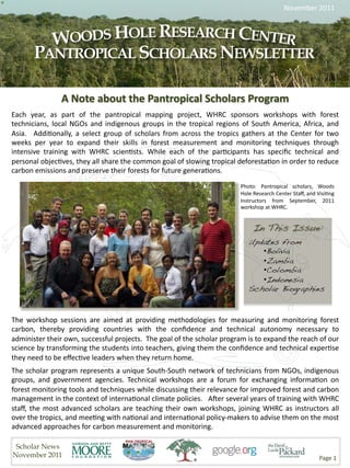
- 1. November 2011 Photo: Pantropical scholars, Woods Hole Research Center Staff, and Visi>ng Instructors from September, 2011 workshop at WHRC. Updates from! • Bolivia! • Zambia! • Colombia! • Indonesia! Scholar Biographies! The workshop sessions are aimed at providing methodologies for measuring and monitoring forest carbon, thereby providing countries with the confidence and technical autonomy necessary to administer their own, successful projects. The goal of the scholar program is to expand the reach of our science by transforming the students into teachers, giving them the confidence and technical exper>se they need to be effec>ve leaders when they return home. The scholar program represents a unique South‐South network of technicians from NGOs, indigenous groups, and government agencies. Technical workshops are a forum for exchanging informa>on on forest monitoring tools and techniques while discussing their relevance for improved forest and carbon management in the context of interna>onal climate policies. AGer several years of training with WHRC staff, the most advanced scholars are teaching their own workshops, joining WHRC as instructors all over the tropics, and mee>ng with na>onal and interna>onal policy‐makers to advise them on the most advanced approaches for carbon measurement and monitoring. Scholar News November 2011 Page 1
- 2. Bolivia Zambia Eric Armijo Abel Siample & Sitwala Wamunyima The past weeks I have focused my aSen>on on On 27th September 2011 (a day aGer arriving from applying the “image segmenta>on & random WHRC – USA), I was requested by the Directorate forest (IS & RF)” approach to detect forest changes of Environment and Natural Resources in the in the Bolivian Amazon. Along this line, two main Ministry of Tourism, Environment and Natural ac>vi>es were developed: a one‐day course to Resources to aSend a technical commiSee train FAN‐Bolivia staff and the assessment of the mee>ng for the West Lunga Carbon Project technique to produce a deforesta>on map. spearheaded by the Zambia Wildlife Authority (ZAWA). My main role in this mee>ng was to providing technical guidance in planning and execu>ng of a forest resource assessment meant to collect data and generate informa>on on the carbon storage and sequestra>on poten>al for the project area. The project area covers an area of 600,000 ha in extent and lies in the Northwestern province of Zambia with rela>vely high biomass content due to high forest cover density (above 70% canopy cover). Image shows material developed to train FAN‐Bolivia staff in the IS & RF approach to detect forest change The course provided an opportunity to adapt the exis>ng training material (presenta>on, script and dataset) to a Spanish‐speaking audience. A study area in Bolivia was picked to exemplify the use of tools and methods. Having performed a series of assessments to the IS On 3rd October & RF technique, it was found suitable to update a 2011, I conducted land cover change map for a 2.8 million hectares a technical area in the Bolivian Amazon. The new 2008‐2010 presenta>on deforesta>on map is currently being refined and before senior will support monitoring ac>vi>es for a REDD+ Pilot management in the Ministry including Program project. representa>ves from the coopera>ng partners (i.e. Keep up with scholar news by liking us United Na>ons Development Program, Food and on Facebook. Find us at “Woods Hole Agriculture Organiza>on, Finnish Embassy and Pantropical Forest Monitoring Network.” ! European union). My presenta>on (cont. p.3)… Scholar News November 2011 Page 2
- 3. Zambia (con=nued) Abel Siample & Sitwala Wamunyima was based on lessons learnt at WHRC specifically on mapping of biomass (for carbon accoun>ng) and forest cover change. On 7th October 2011, I led 3 field teams of Forest Ecologists, Soil Scien>sts and Wildlife Scouts into the field to conduct a forest inventory for 5 weeks. The target was collect data (field training data) from 300 plots including some established following GLAS shot foot prints. We have just completed the exercise and I will be gekng to the office next Monday 14th November 2011. ___________________________________________________ Indonesia ensure the sustainability of the environment and the people’s welfare. For this purpose I intend to Virni Budi Arifan= AGer my return from the Woods Hole Research use Dinamica EGO soGware for landcover change modeling which I have learned in WHRC. Center, I have done some field works for my rou>ne research ac>vity in my ins>tu>on, in Con=nued p. 4... Forest Research and Development Agency, Ministry of Forestry of Indonesia. I went to Bangka island for conduc>ng research to analyze the driver of landcover and landuse change on a very degraded watershed due to vast mining explora>on. The objec>ve of this research is to analyze how the watershed should be managed by considering the local community’s livelihood which was benefited by the presence of the mining companies and how this landcover/ landuse change can be modeled in the future to Photo: Abandoned mining area Scholar News November 2011 Page 3
- 4. Indonesia (con=nued) Virni Budi Arifan= In the upcoming months, I am asked by my supervisor to do biomass and emission mapping in Meru Be>ri Na>onal Park. At this >me we are s>ll searching on the best satellite imageries with high resolu>on and low cloud cover over the area. I intend to use the method that I have learned in WHRC on biomass and emission mapping. I also hope to s>ll be get in touch with the WHRC team for any ques>ons or advise regarding the mapping techniques. Thank you WHRC! ___________ Visit our Pantropical Education and Capacity Building Web Page: http:// www.whrc.org/education/ capacitybldg.html! ___________ Colombia Edersson Cabrera, Paola Giraldo, & Diana Vargas In the context of the project "Enabling the Photo: Virni and colleagues in the field ___________ Technical Ins>tu>onal Capacity to Support REDD projects in Colombia", the Hydrology, Semi automa>c algorithms test in order to Meteorology and Environmental Studies Ins>tute classify op>cal and RADAR images with of Colombia ‐ IDEAM, in partners with The Woods Random Forest Hole Research Center ‐WHRC, has worked this Semi automa>c algorithms test in order to two last years in ac>vi>es to support Colombia es>mate Carbon stocks using coarse resolu>on capaci>es in the monitoring of forest cover, images (eg. MODIS) cont. p. 5 … including deforesta>on quan>fica>on and es>ma>on of Carbon stocks with digital processing of satellite Op>cal images and Radar images. Both ins>tu>ons have developed together the following ac>vi>es: Par>cipa>on of the IDEAM professional research team in the WHRC capacity annual programs. Pre processing of RADAR images, using the WHRC's WHIPS capacity. Scholar News November 2011 Page 4
- 5. Colombia (Con=nued) Edersson Cabrera, Paola Giraldo, & Diana Vargas Specifically, the IDEAM has been benefited from WHRC's technical capacity throughout their technical developments to improve the mapping of forest ‐ non forest in the Pacific region of Colombia. There is frequent the presence of clouds, shades, mist and / or haze, which cannot be recognized in op>cal sensors. In this way, in 2011 were implemented the use of ALOS PALSAR images (FBS and FBD modes) in the Pacific region in order to map this area. In comparison, it was possible to cover the 99.08 percent of this area in 2010 while in 2005 only a 75 percent of it was covered. Working together has let a feedback of technical experiences for both teams, iden>fying new technical possibili>es of work collabora>on. For IDEAM, this kind of inves>ga>on alliances has shown the usefulness to improve the technical capaci>es and we hope to con>nue with this sort of ac>vi>es. ___________________________________________________ Virni Budi Aifan= Mrs. Arifan> is a remote sensing scien>st at Research Center for Climate Change and Forest Policy, Ministry of Forestry of Indonesia. Her research interests focus on monitoring land cover, land cover change, forest carbon, landscape analysis, and adapta>on strategies of forest communi>es to climate change at several ecosystems. She holds her Bachelor degree in Forest Management from Bogor Agricultural Ins>tute in Bogor, Indonesia, and her MSc in Forestry majoring Spa>al Informa>on Techniques in Ghent University, Belgium. Before joining the Ministry of Forestry, she worked at Center for Interna>onal Forestry Research (CIFOR) in Bogor, Indonesia, the European Union for Forest Inventory and Monitoring Project in Jakarta, and PT. Surveyor Indonesia in Jakarta, Indonesia. ___________ Eric Armijo Mr. Armijo, land change analyst at FAN‐Bolivia, is interested in the use of geospa>al techniques to characterize and model land use an land change processes in tropical regions of Bolivia, South America. He is currently in charge of building deforesta>on baselines for a REDD program in the Bolivian Amazon. Mr. Armijo holds a B.S. in computer science from UPSA University in Bolivia and a M.A. in geography from the University of Maryland, College Park (US). ___________ Scholar News November 2011 Page 5
- 6. Mike Chirwa Mr. Chirwa works for Forestry Research Ins>tute of Malawi (FRIM), Malawi, as a resource monitoring officer. He is currently working on various programs within Malawi, one of which is Lake Chilwa Basin Climate Change Adapta>on Programme (LCBCCAP) in Southern Malawi where his responsibility is to monitor forest cover, biomass, and carbon stock change. He has also been engaged in in‐country simula>on and pilo>ng of carbon financing programmes such as REDD (e.g Nkuwazi in Northern Malawi). In his MSc., he looked at an important mul>‐purpose fruit tree species in Southern Africa, Uapaca kirkiana, some its provenances and families, and their poten>al to sequester carbon. His research areas of interest include allometry, policy‐resource scenario simula>on and land cover change. ___________ Paola Giraldo Ms. Giraldo is a Forest Engineer whose interestes focus on the use of remote sensing for the mapping of land cover, land cover change, mul>temporal analyse, and zonifica>on of protected areas applying mul>criteria analyses. She has been working at the Ins>tute of Hydrology, Meteorology and Enviromental Studies, Colombia since June 2010 and before She worked on land cover classifica>on for natural strategic areas in some of the Natura Funda>on – Colombia projects. ___________ Andreana Paola Mekui Biyogo Ms. Mekui Biyogo works currently like research officer in charge of REDD+ and CDM at Forest department in Gabon. With a degree in forest sciences from ENEF, a Diploma in Geoma>cs from Omar Bongo University and a Master degree in remote sensing of forest resources from University of Moncton. She is Forest Engineer, specialist of remote sensing (small‐footprint airborne LIDAR, Op>cal). She used to work with WWF, for several years like GIS Officer of the Minkebe program. Her last posi>on at WWF has been the Regional Coordinator of the first pilot project of community forestry in her country (Gabon). Ms. Mekui Biyogo does consul>ng from >me to >me with FAO and WHRC, respec>vely by managing human‐wildlife conflict and being part of the team of trainers for field measurements protocol on aboveground biomass data collec>on and carbon stock es>ma>on. ___________ Giang Nguyen Vu Mr. Nguyen Vu is a researcher in Department of Remote Sensing Technology, GIS and GPS, at Space Technology Ins>tute (STI) in Vietnam. He is responsible for developing applica>ons of remote sensing and GIS for inves>ga>on, monitoring and management of sustainable use of natural resources. He has been working as technical consultant for NGOs such as Asian Development Bank (ADB), Interna>onal Union for Conserva>on of Nature (IUCN), and Netherlands Development Organiza>on (SNV) where he carried capacity building trainings on land use planning and rural livelihood development; crea>ng land use, land cover maps; and forest cover change analysis. Giang’s interests are in modeling land use and land cover change, es>ma>ng biomass, and crea>ng emission maps from mul>‐sources remote sensing data. He also would like to develop his research on urbaniza>on, importance of open spaces in urban and their effects on land surface temperature paSern. ___________ Grace Nangendo Dr. Nangendo graduated from Makerere University, Uganda, with a bachelor degree in Forestry, from the Interna>onal Ins>tute for Geo‐informa>on Science and earth observa>on (ITC), the Netherlands, with a Master of Science degree in Geo‐informa>on for Forest and Tree Resource Management and, Wageningen University and ITC, the Netherlands, with a Doctorate of Philosophy focusing on conserva>on of forest‐woodland‐savannah mosaics. Grace has experience in the geospa>al industry and in natural resource management. Her interest is in applying a spa>al component to forest dynamics and to other natural resources, in biodiversity and plant ecology, and in local people’s use of forest resources. She has worked with WCS since June 2006 as the Geographical Informa>on Systems (GIS) Manager. Scholar News November 2011 Page 6
- 7. Peter Ndunda Mr. Ndunda is the Geographical Informa>on Systems (GIS) Specialist at the Green Belt Movement. He directs the ac>vi>es of a GIS lab for the Green Belt Movement to support the re‐afforesta>on, climate change and community development efforts in Kenya. In addi>on, he manages the measurement and monitoring ac>vi>es of the Green Belt Movement’s community carbon projects in Kenya. He is a member of the Carbon Measurement Collabora>ve team that is coordinated by the Clinton Climate Inia>ve to support the development of Na>onal Carbon Accoun>ng System (NCAS) in Kenya, Uganda and Tanzania, among other countries. Prior to his posi>on at the Green Belt Movement, Peter worked as a GeoInforma>on Consultant with the WorldBank in Washington DC. He is a graduate of Moi University, Kenya, and the University of Redlands, CA. ___________ Akchousanh Rasphone Ms. Rasphone is a GIS/Spa>al Landscape Ecologist interested in carbon and forest cover/change mapping and species habitat distribu>on modeling. Ms. Rasphone received her Bachelor of Technology in GIS from the University of Southern Queensland (Australia) and her M.S. in Geographical Science from the Australian Na>onal University. Ms. Rasphone is currently working with the Wildlife Conserva>on Society Lao PDR on a biodiversity conserva>on project in the southern landscape of Laos as a project coordinator and GIS/Spa>al Landscape Ecologist. ___________ Abel Siampale Mr. Siampale is a Forester with solid skills in Forest Resource Assessments (Forest Inventories and GIS), currently working for the Forestry Department, Ministry of Tourism, Environment and Natural Resources in Zambia. His interests focus mainly on sustainability and vulnerability assessments, forestry mapping, land use and land cover change with 17 years of experience in using GIS. Before becoming a scholar with woods hole research center (WHRC), he served as a Na>onal Consultant in Zambia for the integrated land‐use assessment (ILUA) project under FAO and helped generate the current deforesta>on rate (map) for Zambia. Holds an undergraduate diploma in forestry management, and postgraduate qualifica>on in Geo‐informa>cs. ___________ Mukund Srivastava Mr. Srivastava a professional forester and a member of the Indian Forest Service (IFS). He has nearly 21 years of field experience working in various capaci>es including Chief Conservator of Forests (Environment). He currently works as Joint Director, Forest Survey of India and Head of Na>onal Forest Data Management Centre at FSI Head Quarters at Dehradun, India. He received his Masters in Physics from the Indian Ins>tute of Technology, Kanpur and Master of Technology (M.Tech) in RS and GIS from the Indian Ins>tute of Remote Sensing, Dehradun, India. He has published papers on Forest Produc>vity and Forest Fire Monitoring using RS and has wide experience in public par>cipa>on in forest management. He is a member of a number of Government of India commiSees and Technical Advisory CommiSees of provinces. He is taking special ini>a>ves to factor in the latest technical interven>ons to improve forest cover mapping and biomass mapping. ___________ Isabel Trejo Ms. Trejo is a biologist, working in CONABIO (Na>onal Commission for the Use and Knowledge of Biodiversity), in a project called Bio‐Decision Support System (SSD), which seeks to create a soGware to perform environmental impact analysis and can be used by individuals and/or ins>tu>ons that require guidance on the environmental impact would the construc>on of any infrastructure. She is currently developing ways to measure the impact of a pipeline that runs from Colima to Guadalajara. The goal is to develop tools for the con>nued use of the system. She is personally interested in achieving her degree in mul>‐ scale distribu>on of species to provide a tool of the poten>al distribu>on of the same while using this tool in order for the SSD to get future scenarios of the impact on the species. Scholar News November 2011 Page 7
- 8. Diana Vargas Ms. Vargas is an agricultural engineer with postgraduate studies in environmental impact assessment, MsC in environment and management of biodiversity. She has professional experience in geographic informa>on systems and use of remote sensing for monitoring natural resources, with emphasis on the analysis of land cover. She is an expert in climate change, especially in issues related to accoun>ng of emissions from land use, land use change and forestry (LULUCF) and the REDD mechanism. She is currently involved in the project "Building Technical and Scien>fic Capacity to support REDD Projects in Colombia" in IDEAM, as part of the working team developing and implemen>ng protocols for digital processing of satellite images for the quan>fica>on of deforesta>on. ___________ Sitwala Wamunyima Mr. Wamunyima received a Master of Science Degree in Geoinforma>on Science and Earth Observa>on ‐ Natural Resources Management specializing in Environmental Systems Analysis and Management followed by studies at ITC, The Netherlands. He has built his career in the field of forest resources management since 1995 when he joined the Forestry Department, one of the government departments in the Ministry of Tourism, Environment and Natural Resources in Zambia. He s>ll serves in the Forestry Department and is involved in forest inventories, applica>on of remote sensing for forest monitoring, and large scale mapping. He also contributes to the decision pool for the Forestry Department on aspects of budge>ng, strategic planning, and policy direc>on. ___________________________________________________ Scholar News November 2011 Page 8