SlideShare ist ein Scribd-Unternehmen logo
1 von 171
Longitude and Latitude
Latitude and Longitude
Unit includes:
 Compass Rose
 Definitions of latitude and longitude
 Major lines of latitude
 Hemispheres
 Finding locations using latitude and longitude
A compass rose, sometimes called a windrose, is a
figure on a compass, map, nautical chart or
monument used to display the orientation of the
cardinal directions—North, East, South and West—
and their intermediate points.
Objectives
 Students will be able to identify lines of latitude on a map including
 Equator
 North Pole
 South Pole
 Antarctic Circle
 Tropic of Cancer
 Arctic Circle
 Tropic of Capricorn.
 Students will be able to identify lines of longitude on a map including
 Prime Meridian
Objectives
 Students will be able to locate all four hemispheres including
 Northern Hemisphere
 Southern Hemisphere
 Eastern Hemisphere
 Western Hemisphere
 Students will be able to identify which line divides the earth into the
correct hemispheres.
 Students will be able to find locations on map using longitude and
latitude.
Materials
 Compass Rose Worksheet
 Globe
 World Map
 Latitude Worksheet
 Longitude Worksheet
 Different colors of yarn
 Scissors
 Matching Note cards
 Map of world showing latitude and longitude
 Globe Bingo Worksheet
 Skittles
 Student minds
 Compass Rose Map Hunt
 Latitude and Longitude Worksheet
 Signing Latitude and Longitude
 Yarning about Latitude and Longitude
 Match Latitude and Longitude
 Major lines of latitude worksheet
 Globe Says…activity about major lines of latitude
 Globe Bingo
Activities
Pre-Assessment
 Can you…
 draw and label a compass rose?
 identify the Equator and Prime Meridian on a map?
 label all the major lines of latitude on a map?
 Identify what line of latitude divides the earth into the
Northern and Southern Hemisphere? Can you identify these
hemispheres on a map?
 Identify what line of longitude divides the earth into the
Western and Eastern Hemisphere? Can you identify these
hemispheres on a map?
Compass Rose Map Hunt
 Students will draw and label a compass rose.
 Students will discuss why a compass rose is important.
 Students will locate cardinal roses on various types of maps.
 Students will discuss what a compass rose is used for and who
uses a compass rose.
Latitude
 Students will be introduced to latitude and longitude.
 Students will complete the latitude worksheet.
 Students will trace the equator in green and the other
lines of latitude in blue.
Signing Latitude
 Latitude:
 “I'm climbing the Ladder of latitudes,
latitudes, latitudes.
I'm climbing the ladder of latitudes, all
around the world.”
Longitude
 Students will be introduced to
longitude by looking at the globe.
 Students will complete the lines of
longitude worksheet.
 Students will trace the Prime
Meridian in orange and the other
lines of longitude in yellow.
Signing Longitude
 Longitude:
 “It's a LONG, LONG way from pole to
pole, pole to pole, pole to pole
It's a LONG, LONG way from pole to
pole, so we call those LONGITUDES.”
“Yarning about Latitude and Longitude”
 Students will participate in making a globe
 Four students will be in North, South, East, and West
positions
 Different colors of yarn will make
 Lines of latitude
 Lines of longitude
 Equator
 Prime Meridian
 North Pole
 South Pole
Major lines of Latitude
 Students will do the Major lines of latitude
worksheet.
 Students will locate the major lines of
latitude on the map.
 Students will identify the latitude degree of
each major line of latitude.
 North Pole
 Arctic Circle
 Tropic of Cancer
 Equator
 Tropic of Capricorn
 Antarctic Circle
 South Pole
Major lines of latitude
 North Pole
 Arctic Circle
 Tropic of Cancer
 Equator
 Tropic of Capricorn
 Antarctic Circle
 South Pole
Major lines of latitude
Globe Says…
 North Pole
 Arctic Circle
 Tropic of Cancer
 Equator
 Tropic of Capricorn
 Antarctic Circle
 South Pole
 Students will complete the worksheet on the major lines of latitude
 After learning the major lines of latitude students will perform
Globe says….
 Body parts represent the major lines of latitude
 Top of head – North Pole
 Ears – Arctic Circle
 Shoulders – Tropic of Cancer
 Waist – Equator
 Knees – Tropic of Capricorn
 Shins – Antarctic Circle
 Toes – South Pole
Globe Says
 To review, students will be given a
Blank Globe Bingo Worksheet.
 Students will fill in the sheet before
the next day’s class.
Globe Bingo
Globe Bingo
G L O B E
Word List
Equator Prime Meridian North Pole South Pole
Meridians Parallels East and West Cardinal Rose
Tropic of Cancer Antarctic Circle North and South East
Arctic Circle Tropic of Capricorn Northern Hemisphere Southern Hemisphere
 Students should be able to:
 Draw and label a Compass Rose
 Identify the major lines of latitude and longitude on a map
 Correctly label all four Hemispheres on a map
 Find locations on a map using
latitude and longitude
Assessment
Typical Graph
• This is an example of a typical graph
we are all familiar with.
• The graph is made up of different
“points” with lines that connect
the points.
Typical Graph
•Each point has two
values:
• The “X” value that
runs along the
horizontal “X”
axis
•The “Y” value that
runs along the
vertical “Y” axis
Y axis
X axis
• X value is always stated first
• Followed by the Y value
• The “origin” is the point where
the 2 axes intersect with a value
of (0,0)
(0,0)
(3,8)Y
X
(9,5)
• A point can also have negative (-) values
• Negative X values are to the left of the origin
(0,0)
• Negative Y values are below the
origin
X
Y
(-X,+Y)
(+X,-Y)
(+X,+Y)
(-X,-Y)
(0,0)
East West, North South on The Earth
• Let the X axis be the Equator.
• Let the Y axis be the Prime Meridian
that runs through Greenwich outside
of London.
• Lat/Long are the 2 grid points by
which you can locate any point on
earth.
Y
X
East West, North South on the Earth
• Let each of the four
quarters then be designated
by North or South and East
or West.
N
S
EW
East West, North South on the Earth
•The N tells us we’re
north of the Equator.
The S tells us we’re
south of the Equator.
•The E tells us that
we’re east of the
Prime Meridian. The
W tells us that we’re
west of the Prime
Meridian.
(N, W) (N, E)
(S, W) (S, E)
East West, North South on the Earth
• That means all points in India will
have a North latitude and a East
longitude because it is North of
the Equator and East of the Prime
Meridian.
(N, E)
Prime Meridian
East West, North South on the Earth
•What would be the
latitude and
longitude
directions in
Australia?
Prime Meridian
If you said South and East , you’re right!
What is Latitude?
• Latitude is the distance from the
equator along the Y axis.
• All points along the equator have a
value of 0 degrees latitude.
• North pole = 90°N
• South pole = 90°S
• Values are expressed in terms of
degrees.
Y
X
90°S
90°N
What is Latitude?
•Each degree of latitude is
divided into 60 minutes.
• Each minute is divided into
60 seconds.
Y
X
90°S
90°N
This is also true of
longitude.
What is Latitude?
•For Example:
•37°, 02’,51’’N
•This is close to
the latitude
where you live.
Y
X
90°S
90°N
What is Longitude?
• Longitude is the distance from the
prime meridian along the X axis.
• All points along the prime meridian
have a value of 0 degrees longitude.
• The earth is divided into two parts,
or
hemispheres, of east and west
longitude.
Y
X
180°W 180°E
What is Longitude?
• The earth is divided into 360
equal slices (meridians)
• 180 west and 180 east of the
prime meridian
Y
X
180°W 180°E
What is Latitude?
•Our latitude and
longitude might be:
•30°, 44’,13’’N
•76°, 47’, 14’’E
•Chandigarh
Y
X
90°S
90°N
So Where is (0,0)?
•The origin point (0,0) is
where the equator
intersects the prime
meridian.
•(0,0) is off the western
coast of Africa in the
Atlantic Ocean.
See If You Can Tell In Which Quarter
These Lon/Lats Are Located
• 1. 41°N, 21°E
• 2. 37°N, 76°W
• 3. 72°S, 141°W
• 4. 7°S, 23°W
• 5. 15°N, 29°E
• 6. 34°S, 151°E
A B
C D
•1. B
•2. A
•3. C
•4. C
•5. B
•6. D
•See if you can find
those same
latitude/longitude
locations on a map!
Equator Latitude 0o
Latitude: (90oN to 90oS)
Latitude 23½o NorthTropic of Cancer
Latitude 23½o SouthTropic of Capricorn
Longitude 30o East
Longitude 60o East
Longitude 30o West
Longitude 60o West
Positioning on the Earth’s Surface
East is the direction of
rotation of the Earth North Pole
South Pole
23½o
23½o
66½o90o
900
21st June
22nd December
22nd Sept
20th March
30oE60oE90oE90oW30oW60oW
Longitude 90oEast
Longitude 90o West
Prime Meridian
0o Longitude
Longitude: (180oE to 180oW)
Latitude and Longitude together enable the fixing of position on the Earth’s surface.
Now you’re ready to find some locations
on a map!
TIME ZONES
Math and Geography
in Action
Earth’s Seasons
1
2
3
4
5
6
7
8
9
10
11
12
13
14
15
16
17
Why so many Time Zones?
North
Pole
15°
1 revolution of Earth = 365.25 days
6 hours x 4 years = Leap year
& we catch up
1 rotation of Earth = 24 hours
Circle = 360°
360° /24 = 15° = 1 hour
Earth rotates 15° each hour
At the equator Earth ≈ 24,900 miles
= 1037.5 miles in an hour
Likened to a Number Line
ADD and hour
for each time zone
as you move EAST
SUBTRACT an hour
for each time zone
as you move WEST
- 0 +
Your place
of origin
World Time Zones
• Areas of the world on non-
standard time
• 2 South Pacific islands
• India
• Afghanistan
• Nepal
• Iran
• Sri Lanka
• Newfoundland
• Central Australia
• Myanmar (Burma)
Non- Standard Time
The deviation of time
keeping from the standard
time zone in which a place
is geographically located.
The usual deviation occurs
in quarter hour
increments, i.e. 15
minutes, 30 minutes, or 45
minutes.
USING WHAT YOU HAVE LEARNED
True or False:
If EVERY part of the statement is TRUE, write T.
If ANY part of the statement is FALSE, write F.
1. The earth makes one complete rotation every 24 hours.
2. For every 15° of longitude, there is a difference of one hour in time.
3. Time zones always have straight boundaries.
4. It is 12 noon everywhere on the earth at the same time.
5. The letters a.m. stand for the 12 hours before 12 noon.
6. Post meridiem means the 12 hours after 12 noon.
7. The line of longitude at 180° is called the Prime Meridian.
8. When you travel across the International Date Line you stay in the same day.
9. When you cross the Prime Meridian, you stay in the same day.
10. It takes one hour for the earth to rotate 15°.
True or False
1. In what areas of the world do you find non-standard time?
2. You are in New York and you want to call someone in Rome, Italy, at noon Rome time.
When would you call?
3. Assume that flying from New York to London requires 6 hours. When would a flight
leaving New York on a Wednesday at 6:00 p.m. arrive in London?
4. You are flying from Los Angeles to Moscow. You leave Los Angeles at 10:00 a.m. on
Saturday and you arrive in Moscow on Sunday at 9:00 a.m. How many hours did you
actually spend flying?
5. You are planning a flight from Bombay, India, to Washington, D.C., that must connect
through several cities. You will leave Bombay on August 2, at 8:00 A.M., and will continue
directly through Beijing and Los Angeles to Washington, D.C. What time is it in
Washington, D.C., when you begin your trip? What will be the date when you arrive in
Washington, D.C.?
6. If it is 3:00 p.m. in Greenwich, what time is it in India?
7. If it is 9:00 A.M. in Cape Town, what time is it in Washington, D.C.?
8. If it is Tuesday, 4:30 p.m. in Japan, what day and time is it in Honolulu?
9. If it is Friday, 8:15 A.M. in Rio de Janeiro what day and time is it in Beijing?
Time it! Practice
Latitude and Longitude
Lines of
longitude only
Equator
added Other lines of
latitude added
Cross-sections
through lines of
latitude
Cross-section
through line of
longitude
Orange cut
through
lines of
longitude
Orange cut through lines of
latitude
Draw a map
of this world.
There are 4
countries:
Red, Light
Green, Dark
Green and
Purple.
Latitude and Longitude
Latitude lines run east/west but they measure north or south
of the equator (0°) splitting the earth into the Northern
Hemisphere and Southern Hemisphere.
Latitude
North Pole
South Pole
Lines of
latitude are
numbered
from 0° at
the equator
to 90° N.L. at
the North
Pole.
Lines of
latitude are
numbered
from 0° at
the equator
to 90° S.L.
at the
South Pole.
]
[
90 80
70
60
50
40
20
30
10
90
80
70
60
50
40
20
10
30
Latitude
The North Pole
is at 90° N
The South Pole
is at 90° S
The equator
is at 0°
latitude. It is
neither
north nor
south. It is
at the center
between
north and
south.
40° N is the 40°
line of latitude
north of the
equator.
40° S is the 40°
line of latitude
south of the
equator.
Longitude
Lines of longitude begin
at the Prime Meridian.
60° W is the
60° line of
longitude west
of the Prime
Meridian.
The Prime Meridian is located at 0°. It is neither east or west
60° E is the
60° line of
longitude
east of the
Prime
Meridian.
W E
Longitude
Lines of longitude are numbered east from the
Prime Meridian to the 180° line and west from the
Prime Meridian to the 180° line.
PRIME MERIDIAN
WestLongitude
EastLongitude
180
°
N
EW
S
North Pole
Prime Meridian
The Prime Meridian (0°) and the 180° line split the earth
into the Western Hemisphere and Eastern Hemisphere.
Prime Meridian
Western
Hemisphere
Eastern
Hemisphere
Places located east of the Prime Meridian have an east
longitude (E) address. Places located west of the Prime
• SEPARATES 2 CALENDAR DAYS.
America to Asia – gain a day
Asia to America – lose a day
INTERNATIONAL DATE LINE
180°
By combining latitude and longitude, any location
can be pinpointed
A location’s coordinates
(____° N or S, ____ ° E or W)
W E
S
Application
N
India is in the Northern Hemisphere because it is north of the
Equator. India is in the Eastern Hemisphere because it is east of
the Prime Meridian.
Fractions of a Degree
• 1 degree = 60 minutes or 1 minute is 1/60th of a degree
• Use minutes if location is not directly on the latitude/longitude line
• Written ----- Degree/minute = XX° xx’ compass direction
30’ is half-way
between
degrees
 The world rotates (spins) 360° in 24 hours.
360° / 24 hours = 15° per hour
 The world has 24 time zones, each l5° apart.
THERE IS A 1 HOUR TIME DIFFERENCE FOR
EVERY 15° OF LONGITUDE
LONGITUDE AND TIME
 The world rotates west to east (counterclockwise), time
zones to the east are ahead of the those time zones to the
west
Greenwich, England is the logical starting point for
time zones
EAST INCREASE
Time is forward to all places to the east
WEST LESS
Time is backward to all places to the west
ANOTHER CHEESY SAYING
East Increase – West Less
(1 hr per l5°)
If it 9 p.m. at Position D, what time is it at position C? Position B?
If it is 1 p.m. at Position X, at which location is the time 5 p.m.
Earth rotates west to east
Solar time is based on the position of
the sun
NIGHT IS FALLING ON EARTH
Look at the East Coast of the United
States. The lights are already lit.
California the sun is still visible.
This pictures shows
AMERICAN CITIES at
night.
Saguenay
Ottawa
Sept-Iles
Mexico
City
Québec
Montréal
St.John
Those light are Boston, New
York, Philadelphia and
Washington.
Toronto
Detroit
Miami
Havana
Puerto Rico
Houston
Dallas
It’s still daylight
in California
Thunder Bay
Port-au-Prince
NIGHT IS FALLING ON EARTH.
Look at Paris and Barcelona, the lights are
already lit, meanwhile in London, Lisbon and
Madrid the sun is still visible.
Looking south, we can see the islands in the
middle of the ocean.
We have a perfect view of the British Islands,
Iceland and Canada.
India is one of the ancient civilizations in the
world. It has achieved multifaceted socio
economic progress during the last five decades. It
has moved forward displaying remarkable
progress in the field of agriculture, industry,
technology and overall economic development.
India has also contributed significantly to the
making of world history.
To the southeast and southwest of the mainland, lie the Andaman and
Nicobar islands and the Lakshadweep islands in Bay of Bengal and
Arabian Sea respectively.
Latitudes: 8 degree 4’ N and 37 degree 6’ N
Longitudes: 68 degree 7’ E and 97 degree 25’ E
India is divided into almost two equal parts by the Tropic of Cancer (23 degree 30’ N).
Andaman and Nicobar Islands are situated towards the Southeast of the Indian mainland in the Bay of Bengal.
Lakshadweep Islands are situated towards the Southwest of the Indian mainland in the Arabian Sea.
17.09
9.98
9.62 9.59
8.51
7.69
3.28
0
2
4
6
8
10
12
14
16
18
Russia Canada USA China Brazil Australia India
Area of different countries
Area(inmillionsq.km)
Country
17.09
9.98
9.62 9.59
8.51
7.69
3.28
0
2
4
6
8
10
12
14
16
18
Russia Canada USA China Brazil Australia India
Area of different countries
Area(inmillionsq.km)
Country
97.6
2.4
Area
Rest of the world India
Area
Rest of the world India
Maharishi Valmiki has
recorded in his Ramayan-
(Yuudh Kand, sarg 22 and
shlokas 45-73) that Shri
Rama’s army constructed a
bridge over the sea between
Rameswaram and Sri Lanka.
After crossing this bridge, Shri
Rama’s army reached Sri
Lanka, defeated Ravana and
liberated Sita from his
captivity.
It is found exactly at the
location narrated in Valmiki
Ramayan
Space images
taken by NASA
reveal an ancient
bridge in the Palk
Strait between
Bharat and Sri
Lanka.
The existence of the bridge obviously cannot be denied!
However to what extent there was manual intervention in
connecting the gaps between the shoals, islands and rocks
is a subject for detailed marine archaeological and
geological research. This kind of research has never been
carried out nor has any team been constituted so far.
However, there is enough evidence about the existence as
well as the use of this bridge in ancient Bharatiya history,
literature and travelogues etc. 'Ramayana', which mentions
a bridge between Rameshwaram (Bharat) and the Sri-
Lankan coast, constructed under the supervision of the
dynamic and invincible figure of Rama, who is the
incarnate of the supreme.
Of the three major lines, Only Tropic of Cancer passes through India.
Tropic of cancer passing through Indian states are as follows
1-Gujarat
2- Rajasthan
3- Madhaya Pradesh
4- Chattisgarh
5- Jharkhand
6- West Bengal
7- Tripura
8- Mizoram
Tropic of Cancer board near Bhopal, India
"KARK VRUT" a TROPIC OF CANCER passes here approch road to
BHIRANDIARA - KHAVADA - KALODUNGAR of KUTCH.
Latitudes and longitudes and india   size and location

Weitere ähnliche Inhalte

Was ist angesagt?

Latitude & Longitude
Latitude & LongitudeLatitude & Longitude
Latitude & Longitude
simonvanellis
 
Grade 6 geography chapter 1 Earth in the solar system
Grade 6 geography chapter 1 Earth in the solar systemGrade 6 geography chapter 1 Earth in the solar system
Grade 6 geography chapter 1 Earth in the solar system
palitaaarti
 
Latitude And Longitude
Latitude And LongitudeLatitude And Longitude
Latitude And Longitude
guestfeb483d0
 

Was ist angesagt? (20)

Lines of Latitude and Longitude – PowerPoint
Lines of Latitude and Longitude – PowerPointLines of Latitude and Longitude – PowerPoint
Lines of Latitude and Longitude – PowerPoint
 
Geography 6
Geography 6Geography 6
Geography 6
 
Globe: lattitudes and longitudes
Globe: lattitudes  and longitudesGlobe: lattitudes  and longitudes
Globe: lattitudes and longitudes
 
Grade - 6 - Social Science, Geography Chapter 4. Map Reading
Grade - 6 - Social Science, Geography Chapter 4. Map ReadingGrade - 6 - Social Science, Geography Chapter 4. Map Reading
Grade - 6 - Social Science, Geography Chapter 4. Map Reading
 
Latitude & Longitude
Latitude & LongitudeLatitude & Longitude
Latitude & Longitude
 
Grade 6 geography chapter 1 Earth in the solar system
Grade 6 geography chapter 1 Earth in the solar systemGrade 6 geography chapter 1 Earth in the solar system
Grade 6 geography chapter 1 Earth in the solar system
 
Latitude And Longitude
Latitude And LongitudeLatitude And Longitude
Latitude And Longitude
 
Ch 2 latitude and longitude
Ch 2 latitude and longitudeCh 2 latitude and longitude
Ch 2 latitude and longitude
 
Map, Geography class 6 cbse
Map, Geography class 6 cbseMap, Geography class 6 cbse
Map, Geography class 6 cbse
 
Globe latitudes and longitudes
Globe latitudes and longitudesGlobe latitudes and longitudes
Globe latitudes and longitudes
 
Maps & globes
Maps & globesMaps & globes
Maps & globes
 
Ppt of Class 6 ,ch 2, globe , Geography pdf
Ppt of Class 6 ,ch 2, globe , Geography  pdfPpt of Class 6 ,ch 2, globe , Geography  pdf
Ppt of Class 6 ,ch 2, globe , Geography pdf
 
Latitude and longitude
Latitude and longitudeLatitude and longitude
Latitude and longitude
 
Geography - Maps - Class 6
Geography - Maps - Class 6Geography - Maps - Class 6
Geography - Maps - Class 6
 
Latitude and Longitude
Latitude and LongitudeLatitude and Longitude
Latitude and Longitude
 
Movements of the earth
Movements of the earthMovements of the earth
Movements of the earth
 
The earth in the solar system
The earth in the solar systemThe earth in the solar system
The earth in the solar system
 
India size and location
India size and locationIndia size and location
India size and location
 
Maps ppt
Maps pptMaps ppt
Maps ppt
 
Location and time
Location and timeLocation and time
Location and time
 

Andere mochten auch

Latitude and longitude
Latitude and longitudeLatitude and longitude
Latitude and longitude
hookc
 
Latitude and longitude notes
Latitude and longitude notesLatitude and longitude notes
Latitude and longitude notes
jkholland1
 
Latitude And Longitude Primer
Latitude And Longitude PrimerLatitude And Longitude Primer
Latitude And Longitude Primer
Stuart Kirkham
 
Understanding Longitude And Latitude
Understanding Longitude And LatitudeUnderstanding Longitude And Latitude
Understanding Longitude And Latitude
Linda Smith
 
Time zones and international date line (idl
Time zones and international date line (idlTime zones and international date line (idl
Time zones and international date line (idl
Muhammad Sajjad
 

Andere mochten auch (7)

7 ss latitude & longitude
7 ss latitude & longitude7 ss latitude & longitude
7 ss latitude & longitude
 
Latitude and longitude
Latitude and longitudeLatitude and longitude
Latitude and longitude
 
Latitude and longitude notes
Latitude and longitude notesLatitude and longitude notes
Latitude and longitude notes
 
Latitude And Longitude Primer
Latitude And Longitude PrimerLatitude And Longitude Primer
Latitude And Longitude Primer
 
Longitude and Latitude
Longitude and LatitudeLongitude and Latitude
Longitude and Latitude
 
Understanding Longitude And Latitude
Understanding Longitude And LatitudeUnderstanding Longitude And Latitude
Understanding Longitude And Latitude
 
Time zones and international date line (idl
Time zones and international date line (idlTime zones and international date line (idl
Time zones and international date line (idl
 

Ähnlich wie Latitudes and longitudes and india size and location

Latitude and longitude lesson
Latitude and longitude lessonLatitude and longitude lesson
Latitude and longitude lesson
Saeeda Zahoor
 
Longitude and latitude revision copy2
Longitude and latitude revision   copy2Longitude and latitude revision   copy2
Longitude and latitude revision copy2
ssuser6edc69
 
Abbey chapter2 2012
Abbey chapter2 2012Abbey chapter2 2012
Abbey chapter2 2012
nilsona
 
Understandinglongitudeandlatitude
UnderstandinglongitudeandlatitudeUnderstandinglongitudeandlatitude
Understandinglongitudeandlatitude
mrpolizone
 
Types of maps, long, lat, satellites, time zones
Types of maps, long, lat, satellites, time zonesTypes of maps, long, lat, satellites, time zones
Types of maps, long, lat, satellites, time zones
Bantay's Earth Science!
 
_L-14 The Globe- Latitudes and Longitudes new.pptx
_L-14 The Globe- Latitudes and Longitudes new.pptx_L-14 The Globe- Latitudes and Longitudes new.pptx
_L-14 The Globe- Latitudes and Longitudes new.pptx
padminijyothi
 
Chapter 2 - Mapping
Chapter 2 - MappingChapter 2 - Mapping
Chapter 2 - Mapping
cavalierem
 

Ähnlich wie Latitudes and longitudes and india size and location (20)

Longitude and latitude gr 10.pptx
Longitude and latitude gr 10.pptxLongitude and latitude gr 10.pptx
Longitude and latitude gr 10.pptx
 
Earths dimension ppt np1
Earths dimension ppt np1Earths dimension ppt np1
Earths dimension ppt np1
 
Latitude and longitude for Demo.pptx
Latitude and longitude for Demo.pptxLatitude and longitude for Demo.pptx
Latitude and longitude for Demo.pptx
 
Satellite Communication Lec4, Chat Rooms GupshupCorner.com Pakistan.
Satellite Communication Lec4, Chat Rooms GupshupCorner.com Pakistan.Satellite Communication Lec4, Chat Rooms GupshupCorner.com Pakistan.
Satellite Communication Lec4, Chat Rooms GupshupCorner.com Pakistan.
 
Latitude and longitude lesson
Latitude and longitude lessonLatitude and longitude lesson
Latitude and longitude lesson
 
Longitude and latitude revision copy2
Longitude and latitude revision   copy2Longitude and latitude revision   copy2
Longitude and latitude revision copy2
 
Cartography
CartographyCartography
Cartography
 
Abbey chapter2 2012
Abbey chapter2 2012Abbey chapter2 2012
Abbey chapter2 2012
 
Latitude and Longitude
Latitude and Longitude Latitude and Longitude
Latitude and Longitude
 
Aerial NAVIGATION and FLIGHT PLANNING.pptx
Aerial NAVIGATION and FLIGHT PLANNING.pptxAerial NAVIGATION and FLIGHT PLANNING.pptx
Aerial NAVIGATION and FLIGHT PLANNING.pptx
 
Understandinglongitudeandlatitude
UnderstandinglongitudeandlatitudeUnderstandinglongitudeandlatitude
Understandinglongitudeandlatitude
 
longitude-latitude-and-equator-1.pptx
longitude-latitude-and-equator-1.pptxlongitude-latitude-and-equator-1.pptx
longitude-latitude-and-equator-1.pptx
 
latitude_and_longitude.ppt which can be use to teach geography
latitude_and_longitude.ppt which can be use to teach geographylatitude_and_longitude.ppt which can be use to teach geography
latitude_and_longitude.ppt which can be use to teach geography
 
WEEK1-Q4.pptx
WEEK1-Q4.pptxWEEK1-Q4.pptx
WEEK1-Q4.pptx
 
Prime Meridian,Equator, Latitude and longitude
Prime Meridian,Equator, Latitude and longitude Prime Meridian,Equator, Latitude and longitude
Prime Meridian,Equator, Latitude and longitude
 
Types of maps, long, lat, satellites, time zones
Types of maps, long, lat, satellites, time zonesTypes of maps, long, lat, satellites, time zones
Types of maps, long, lat, satellites, time zones
 
Earths dimension sci 8 ppt np1
Earths dimension sci 8 ppt np1Earths dimension sci 8 ppt np1
Earths dimension sci 8 ppt np1
 
_L-14 The Globe- Latitudes and Longitudes new.pptx
_L-14 The Globe- Latitudes and Longitudes new.pptx_L-14 The Globe- Latitudes and Longitudes new.pptx
_L-14 The Globe- Latitudes and Longitudes new.pptx
 
Global Location
Global LocationGlobal Location
Global Location
 
Chapter 2 - Mapping
Chapter 2 - MappingChapter 2 - Mapping
Chapter 2 - Mapping
 

Kürzlich hochgeladen

1029-Danh muc Sach Giao Khoa khoi 6.pdf
1029-Danh muc Sach Giao Khoa khoi  6.pdf1029-Danh muc Sach Giao Khoa khoi  6.pdf
1029-Danh muc Sach Giao Khoa khoi 6.pdf
QucHHunhnh
 
Spellings Wk 3 English CAPS CARES Please Practise
Spellings Wk 3 English CAPS CARES Please PractiseSpellings Wk 3 English CAPS CARES Please Practise
Spellings Wk 3 English CAPS CARES Please Practise
AnaAcapella
 
Jual Obat Aborsi Hongkong ( Asli No.1 ) 085657271886 Obat Penggugur Kandungan...
Jual Obat Aborsi Hongkong ( Asli No.1 ) 085657271886 Obat Penggugur Kandungan...Jual Obat Aborsi Hongkong ( Asli No.1 ) 085657271886 Obat Penggugur Kandungan...
Jual Obat Aborsi Hongkong ( Asli No.1 ) 085657271886 Obat Penggugur Kandungan...
ZurliaSoop
 
The basics of sentences session 3pptx.pptx
The basics of sentences session 3pptx.pptxThe basics of sentences session 3pptx.pptx
The basics of sentences session 3pptx.pptx
heathfieldcps1
 
Russian Escort Service in Delhi 11k Hotel Foreigner Russian Call Girls in Delhi
Russian Escort Service in Delhi 11k Hotel Foreigner Russian Call Girls in DelhiRussian Escort Service in Delhi 11k Hotel Foreigner Russian Call Girls in Delhi
Russian Escort Service in Delhi 11k Hotel Foreigner Russian Call Girls in Delhi
kauryashika82
 

Kürzlich hochgeladen (20)

1029-Danh muc Sach Giao Khoa khoi 6.pdf
1029-Danh muc Sach Giao Khoa khoi  6.pdf1029-Danh muc Sach Giao Khoa khoi  6.pdf
1029-Danh muc Sach Giao Khoa khoi 6.pdf
 
Spellings Wk 3 English CAPS CARES Please Practise
Spellings Wk 3 English CAPS CARES Please PractiseSpellings Wk 3 English CAPS CARES Please Practise
Spellings Wk 3 English CAPS CARES Please Practise
 
Unit-IV- Pharma. Marketing Channels.pptx
Unit-IV- Pharma. Marketing Channels.pptxUnit-IV- Pharma. Marketing Channels.pptx
Unit-IV- Pharma. Marketing Channels.pptx
 
PROCESS RECORDING FORMAT.docx
PROCESS      RECORDING        FORMAT.docxPROCESS      RECORDING        FORMAT.docx
PROCESS RECORDING FORMAT.docx
 
Application orientated numerical on hev.ppt
Application orientated numerical on hev.pptApplication orientated numerical on hev.ppt
Application orientated numerical on hev.ppt
 
Understanding Accommodations and Modifications
Understanding  Accommodations and ModificationsUnderstanding  Accommodations and Modifications
Understanding Accommodations and Modifications
 
Jual Obat Aborsi Hongkong ( Asli No.1 ) 085657271886 Obat Penggugur Kandungan...
Jual Obat Aborsi Hongkong ( Asli No.1 ) 085657271886 Obat Penggugur Kandungan...Jual Obat Aborsi Hongkong ( Asli No.1 ) 085657271886 Obat Penggugur Kandungan...
Jual Obat Aborsi Hongkong ( Asli No.1 ) 085657271886 Obat Penggugur Kandungan...
 
Magic bus Group work1and 2 (Team 3).pptx
Magic bus Group work1and 2 (Team 3).pptxMagic bus Group work1and 2 (Team 3).pptx
Magic bus Group work1and 2 (Team 3).pptx
 
Micro-Scholarship, What it is, How can it help me.pdf
Micro-Scholarship, What it is, How can it help me.pdfMicro-Scholarship, What it is, How can it help me.pdf
Micro-Scholarship, What it is, How can it help me.pdf
 
Holdier Curriculum Vitae (April 2024).pdf
Holdier Curriculum Vitae (April 2024).pdfHoldier Curriculum Vitae (April 2024).pdf
Holdier Curriculum Vitae (April 2024).pdf
 
How to Manage Global Discount in Odoo 17 POS
How to Manage Global Discount in Odoo 17 POSHow to Manage Global Discount in Odoo 17 POS
How to Manage Global Discount in Odoo 17 POS
 
SKILL OF INTRODUCING THE LESSON MICRO SKILLS.pptx
SKILL OF INTRODUCING THE LESSON MICRO SKILLS.pptxSKILL OF INTRODUCING THE LESSON MICRO SKILLS.pptx
SKILL OF INTRODUCING THE LESSON MICRO SKILLS.pptx
 
How to Create and Manage Wizard in Odoo 17
How to Create and Manage Wizard in Odoo 17How to Create and Manage Wizard in Odoo 17
How to Create and Manage Wizard in Odoo 17
 
Third Battle of Panipat detailed notes.pptx
Third Battle of Panipat detailed notes.pptxThird Battle of Panipat detailed notes.pptx
Third Battle of Panipat detailed notes.pptx
 
Unit-IV; Professional Sales Representative (PSR).pptx
Unit-IV; Professional Sales Representative (PSR).pptxUnit-IV; Professional Sales Representative (PSR).pptx
Unit-IV; Professional Sales Representative (PSR).pptx
 
The basics of sentences session 3pptx.pptx
The basics of sentences session 3pptx.pptxThe basics of sentences session 3pptx.pptx
The basics of sentences session 3pptx.pptx
 
Russian Escort Service in Delhi 11k Hotel Foreigner Russian Call Girls in Delhi
Russian Escort Service in Delhi 11k Hotel Foreigner Russian Call Girls in DelhiRussian Escort Service in Delhi 11k Hotel Foreigner Russian Call Girls in Delhi
Russian Escort Service in Delhi 11k Hotel Foreigner Russian Call Girls in Delhi
 
UGC NET Paper 1 Mathematical Reasoning & Aptitude.pdf
UGC NET Paper 1 Mathematical Reasoning & Aptitude.pdfUGC NET Paper 1 Mathematical Reasoning & Aptitude.pdf
UGC NET Paper 1 Mathematical Reasoning & Aptitude.pdf
 
Unit-V; Pricing (Pharma Marketing Management).pptx
Unit-V; Pricing (Pharma Marketing Management).pptxUnit-V; Pricing (Pharma Marketing Management).pptx
Unit-V; Pricing (Pharma Marketing Management).pptx
 
2024-NATIONAL-LEARNING-CAMP-AND-OTHER.pptx
2024-NATIONAL-LEARNING-CAMP-AND-OTHER.pptx2024-NATIONAL-LEARNING-CAMP-AND-OTHER.pptx
2024-NATIONAL-LEARNING-CAMP-AND-OTHER.pptx
 

Latitudes and longitudes and india size and location

  • 1.
  • 3. Latitude and Longitude Unit includes:  Compass Rose  Definitions of latitude and longitude  Major lines of latitude  Hemispheres  Finding locations using latitude and longitude
  • 4. A compass rose, sometimes called a windrose, is a figure on a compass, map, nautical chart or monument used to display the orientation of the cardinal directions—North, East, South and West— and their intermediate points.
  • 5. Objectives  Students will be able to identify lines of latitude on a map including  Equator  North Pole  South Pole  Antarctic Circle  Tropic of Cancer  Arctic Circle  Tropic of Capricorn.  Students will be able to identify lines of longitude on a map including  Prime Meridian
  • 6. Objectives  Students will be able to locate all four hemispheres including  Northern Hemisphere  Southern Hemisphere  Eastern Hemisphere  Western Hemisphere  Students will be able to identify which line divides the earth into the correct hemispheres.  Students will be able to find locations on map using longitude and latitude.
  • 7. Materials  Compass Rose Worksheet  Globe  World Map  Latitude Worksheet  Longitude Worksheet  Different colors of yarn  Scissors  Matching Note cards  Map of world showing latitude and longitude  Globe Bingo Worksheet  Skittles  Student minds
  • 8.  Compass Rose Map Hunt  Latitude and Longitude Worksheet  Signing Latitude and Longitude  Yarning about Latitude and Longitude  Match Latitude and Longitude  Major lines of latitude worksheet  Globe Says…activity about major lines of latitude  Globe Bingo Activities
  • 9. Pre-Assessment  Can you…  draw and label a compass rose?  identify the Equator and Prime Meridian on a map?  label all the major lines of latitude on a map?  Identify what line of latitude divides the earth into the Northern and Southern Hemisphere? Can you identify these hemispheres on a map?  Identify what line of longitude divides the earth into the Western and Eastern Hemisphere? Can you identify these hemispheres on a map?
  • 10. Compass Rose Map Hunt  Students will draw and label a compass rose.  Students will discuss why a compass rose is important.  Students will locate cardinal roses on various types of maps.  Students will discuss what a compass rose is used for and who uses a compass rose.
  • 11. Latitude  Students will be introduced to latitude and longitude.  Students will complete the latitude worksheet.  Students will trace the equator in green and the other lines of latitude in blue.
  • 12. Signing Latitude  Latitude:  “I'm climbing the Ladder of latitudes, latitudes, latitudes. I'm climbing the ladder of latitudes, all around the world.”
  • 13. Longitude  Students will be introduced to longitude by looking at the globe.  Students will complete the lines of longitude worksheet.  Students will trace the Prime Meridian in orange and the other lines of longitude in yellow.
  • 14. Signing Longitude  Longitude:  “It's a LONG, LONG way from pole to pole, pole to pole, pole to pole It's a LONG, LONG way from pole to pole, so we call those LONGITUDES.”
  • 15. “Yarning about Latitude and Longitude”  Students will participate in making a globe  Four students will be in North, South, East, and West positions  Different colors of yarn will make  Lines of latitude  Lines of longitude  Equator  Prime Meridian  North Pole  South Pole
  • 16. Major lines of Latitude  Students will do the Major lines of latitude worksheet.  Students will locate the major lines of latitude on the map.  Students will identify the latitude degree of each major line of latitude.
  • 17.  North Pole  Arctic Circle  Tropic of Cancer  Equator  Tropic of Capricorn  Antarctic Circle  South Pole Major lines of latitude
  • 18.  North Pole  Arctic Circle  Tropic of Cancer  Equator  Tropic of Capricorn  Antarctic Circle  South Pole Major lines of latitude
  • 19.
  • 20.
  • 21. Globe Says…  North Pole  Arctic Circle  Tropic of Cancer  Equator  Tropic of Capricorn  Antarctic Circle  South Pole  Students will complete the worksheet on the major lines of latitude
  • 22.  After learning the major lines of latitude students will perform Globe says….  Body parts represent the major lines of latitude  Top of head – North Pole  Ears – Arctic Circle  Shoulders – Tropic of Cancer  Waist – Equator  Knees – Tropic of Capricorn  Shins – Antarctic Circle  Toes – South Pole Globe Says
  • 23.  To review, students will be given a Blank Globe Bingo Worksheet.  Students will fill in the sheet before the next day’s class. Globe Bingo
  • 24. Globe Bingo G L O B E Word List Equator Prime Meridian North Pole South Pole Meridians Parallels East and West Cardinal Rose Tropic of Cancer Antarctic Circle North and South East Arctic Circle Tropic of Capricorn Northern Hemisphere Southern Hemisphere
  • 25.  Students should be able to:  Draw and label a Compass Rose  Identify the major lines of latitude and longitude on a map  Correctly label all four Hemispheres on a map  Find locations on a map using latitude and longitude Assessment
  • 26.
  • 27. Typical Graph • This is an example of a typical graph we are all familiar with. • The graph is made up of different “points” with lines that connect the points.
  • 28. Typical Graph •Each point has two values: • The “X” value that runs along the horizontal “X” axis •The “Y” value that runs along the vertical “Y” axis Y axis X axis
  • 29. • X value is always stated first • Followed by the Y value • The “origin” is the point where the 2 axes intersect with a value of (0,0) (0,0) (3,8)Y X (9,5)
  • 30. • A point can also have negative (-) values • Negative X values are to the left of the origin (0,0) • Negative Y values are below the origin X Y (-X,+Y) (+X,-Y) (+X,+Y) (-X,-Y) (0,0)
  • 31. East West, North South on The Earth • Let the X axis be the Equator. • Let the Y axis be the Prime Meridian that runs through Greenwich outside of London. • Lat/Long are the 2 grid points by which you can locate any point on earth. Y X
  • 32. East West, North South on the Earth • Let each of the four quarters then be designated by North or South and East or West. N S EW
  • 33. East West, North South on the Earth •The N tells us we’re north of the Equator. The S tells us we’re south of the Equator. •The E tells us that we’re east of the Prime Meridian. The W tells us that we’re west of the Prime Meridian. (N, W) (N, E) (S, W) (S, E)
  • 34. East West, North South on the Earth • That means all points in India will have a North latitude and a East longitude because it is North of the Equator and East of the Prime Meridian. (N, E) Prime Meridian
  • 35. East West, North South on the Earth •What would be the latitude and longitude directions in Australia? Prime Meridian If you said South and East , you’re right!
  • 36. What is Latitude? • Latitude is the distance from the equator along the Y axis. • All points along the equator have a value of 0 degrees latitude. • North pole = 90°N • South pole = 90°S • Values are expressed in terms of degrees. Y X 90°S 90°N
  • 37. What is Latitude? •Each degree of latitude is divided into 60 minutes. • Each minute is divided into 60 seconds. Y X 90°S 90°N This is also true of longitude.
  • 38. What is Latitude? •For Example: •37°, 02’,51’’N •This is close to the latitude where you live. Y X 90°S 90°N
  • 39.
  • 40. What is Longitude? • Longitude is the distance from the prime meridian along the X axis. • All points along the prime meridian have a value of 0 degrees longitude. • The earth is divided into two parts, or hemispheres, of east and west longitude. Y X 180°W 180°E
  • 41.
  • 42. What is Longitude? • The earth is divided into 360 equal slices (meridians) • 180 west and 180 east of the prime meridian Y X 180°W 180°E
  • 43. What is Latitude? •Our latitude and longitude might be: •30°, 44’,13’’N •76°, 47’, 14’’E •Chandigarh Y X 90°S 90°N
  • 44. So Where is (0,0)? •The origin point (0,0) is where the equator intersects the prime meridian. •(0,0) is off the western coast of Africa in the Atlantic Ocean.
  • 45. See If You Can Tell In Which Quarter These Lon/Lats Are Located • 1. 41°N, 21°E • 2. 37°N, 76°W • 3. 72°S, 141°W • 4. 7°S, 23°W • 5. 15°N, 29°E • 6. 34°S, 151°E A B C D
  • 46. •1. B •2. A •3. C •4. C •5. B •6. D
  • 47. •See if you can find those same latitude/longitude locations on a map!
  • 48. Equator Latitude 0o Latitude: (90oN to 90oS) Latitude 23½o NorthTropic of Cancer Latitude 23½o SouthTropic of Capricorn Longitude 30o East Longitude 60o East Longitude 30o West Longitude 60o West Positioning on the Earth’s Surface East is the direction of rotation of the Earth North Pole South Pole 23½o 23½o 66½o90o 900 21st June 22nd December 22nd Sept 20th March 30oE60oE90oE90oW30oW60oW Longitude 90oEast Longitude 90o West Prime Meridian 0o Longitude Longitude: (180oE to 180oW) Latitude and Longitude together enable the fixing of position on the Earth’s surface.
  • 49. Now you’re ready to find some locations on a map!
  • 50. TIME ZONES Math and Geography in Action
  • 51.
  • 52.
  • 53.
  • 54.
  • 56. 1 2 3 4 5 6 7 8 9 10 11 12 13 14 15 16 17 Why so many Time Zones? North Pole 15° 1 revolution of Earth = 365.25 days 6 hours x 4 years = Leap year & we catch up 1 rotation of Earth = 24 hours Circle = 360° 360° /24 = 15° = 1 hour Earth rotates 15° each hour At the equator Earth ≈ 24,900 miles = 1037.5 miles in an hour
  • 57. Likened to a Number Line ADD and hour for each time zone as you move EAST SUBTRACT an hour for each time zone as you move WEST - 0 + Your place of origin
  • 59.
  • 60. • Areas of the world on non- standard time • 2 South Pacific islands • India • Afghanistan • Nepal • Iran • Sri Lanka • Newfoundland • Central Australia • Myanmar (Burma) Non- Standard Time The deviation of time keeping from the standard time zone in which a place is geographically located. The usual deviation occurs in quarter hour increments, i.e. 15 minutes, 30 minutes, or 45 minutes.
  • 61. USING WHAT YOU HAVE LEARNED True or False: If EVERY part of the statement is TRUE, write T. If ANY part of the statement is FALSE, write F. 1. The earth makes one complete rotation every 24 hours. 2. For every 15° of longitude, there is a difference of one hour in time. 3. Time zones always have straight boundaries. 4. It is 12 noon everywhere on the earth at the same time. 5. The letters a.m. stand for the 12 hours before 12 noon. 6. Post meridiem means the 12 hours after 12 noon. 7. The line of longitude at 180° is called the Prime Meridian. 8. When you travel across the International Date Line you stay in the same day. 9. When you cross the Prime Meridian, you stay in the same day. 10. It takes one hour for the earth to rotate 15°. True or False
  • 62. 1. In what areas of the world do you find non-standard time? 2. You are in New York and you want to call someone in Rome, Italy, at noon Rome time. When would you call? 3. Assume that flying from New York to London requires 6 hours. When would a flight leaving New York on a Wednesday at 6:00 p.m. arrive in London? 4. You are flying from Los Angeles to Moscow. You leave Los Angeles at 10:00 a.m. on Saturday and you arrive in Moscow on Sunday at 9:00 a.m. How many hours did you actually spend flying? 5. You are planning a flight from Bombay, India, to Washington, D.C., that must connect through several cities. You will leave Bombay on August 2, at 8:00 A.M., and will continue directly through Beijing and Los Angeles to Washington, D.C. What time is it in Washington, D.C., when you begin your trip? What will be the date when you arrive in Washington, D.C.? 6. If it is 3:00 p.m. in Greenwich, what time is it in India? 7. If it is 9:00 A.M. in Cape Town, what time is it in Washington, D.C.? 8. If it is Tuesday, 4:30 p.m. in Japan, what day and time is it in Honolulu? 9. If it is Friday, 8:15 A.M. in Rio de Janeiro what day and time is it in Beijing? Time it! Practice
  • 64. Lines of longitude only Equator added Other lines of latitude added
  • 66. Orange cut through lines of longitude Orange cut through lines of latitude
  • 67. Draw a map of this world. There are 4 countries: Red, Light Green, Dark Green and Purple.
  • 68.
  • 70. Latitude lines run east/west but they measure north or south of the equator (0°) splitting the earth into the Northern Hemisphere and Southern Hemisphere.
  • 71. Latitude North Pole South Pole Lines of latitude are numbered from 0° at the equator to 90° N.L. at the North Pole. Lines of latitude are numbered from 0° at the equator to 90° S.L. at the South Pole. ] [ 90 80 70 60 50 40 20 30 10 90 80 70 60 50 40 20 10 30
  • 72. Latitude The North Pole is at 90° N The South Pole is at 90° S The equator is at 0° latitude. It is neither north nor south. It is at the center between north and south. 40° N is the 40° line of latitude north of the equator. 40° S is the 40° line of latitude south of the equator.
  • 73. Longitude Lines of longitude begin at the Prime Meridian. 60° W is the 60° line of longitude west of the Prime Meridian. The Prime Meridian is located at 0°. It is neither east or west 60° E is the 60° line of longitude east of the Prime Meridian. W E
  • 74. Longitude Lines of longitude are numbered east from the Prime Meridian to the 180° line and west from the Prime Meridian to the 180° line. PRIME MERIDIAN WestLongitude EastLongitude 180 ° N EW S North Pole
  • 75. Prime Meridian The Prime Meridian (0°) and the 180° line split the earth into the Western Hemisphere and Eastern Hemisphere. Prime Meridian Western Hemisphere Eastern Hemisphere Places located east of the Prime Meridian have an east longitude (E) address. Places located west of the Prime
  • 76. • SEPARATES 2 CALENDAR DAYS. America to Asia – gain a day Asia to America – lose a day INTERNATIONAL DATE LINE 180°
  • 77. By combining latitude and longitude, any location can be pinpointed
  • 78. A location’s coordinates (____° N or S, ____ ° E or W)
  • 79. W E S Application N India is in the Northern Hemisphere because it is north of the Equator. India is in the Eastern Hemisphere because it is east of the Prime Meridian.
  • 80. Fractions of a Degree • 1 degree = 60 minutes or 1 minute is 1/60th of a degree • Use minutes if location is not directly on the latitude/longitude line • Written ----- Degree/minute = XX° xx’ compass direction 30’ is half-way between degrees
  • 81.  The world rotates (spins) 360° in 24 hours. 360° / 24 hours = 15° per hour  The world has 24 time zones, each l5° apart. THERE IS A 1 HOUR TIME DIFFERENCE FOR EVERY 15° OF LONGITUDE LONGITUDE AND TIME
  • 82.  The world rotates west to east (counterclockwise), time zones to the east are ahead of the those time zones to the west Greenwich, England is the logical starting point for time zones
  • 83. EAST INCREASE Time is forward to all places to the east WEST LESS Time is backward to all places to the west ANOTHER CHEESY SAYING
  • 84. East Increase – West Less (1 hr per l5°) If it 9 p.m. at Position D, what time is it at position C? Position B? If it is 1 p.m. at Position X, at which location is the time 5 p.m.
  • 85. Earth rotates west to east Solar time is based on the position of the sun NIGHT IS FALLING ON EARTH Look at the East Coast of the United States. The lights are already lit. California the sun is still visible.
  • 86. This pictures shows AMERICAN CITIES at night.
  • 87. Saguenay Ottawa Sept-Iles Mexico City Québec Montréal St.John Those light are Boston, New York, Philadelphia and Washington. Toronto Detroit Miami Havana Puerto Rico Houston Dallas It’s still daylight in California Thunder Bay Port-au-Prince
  • 88. NIGHT IS FALLING ON EARTH. Look at Paris and Barcelona, the lights are already lit, meanwhile in London, Lisbon and Madrid the sun is still visible. Looking south, we can see the islands in the middle of the ocean. We have a perfect view of the British Islands, Iceland and Canada.
  • 89.
  • 90.
  • 91.
  • 92.
  • 93. India is one of the ancient civilizations in the world. It has achieved multifaceted socio economic progress during the last five decades. It has moved forward displaying remarkable progress in the field of agriculture, industry, technology and overall economic development. India has also contributed significantly to the making of world history.
  • 94.
  • 95.
  • 96.
  • 97.
  • 98.
  • 99.
  • 100.
  • 101.
  • 102. To the southeast and southwest of the mainland, lie the Andaman and Nicobar islands and the Lakshadweep islands in Bay of Bengal and Arabian Sea respectively.
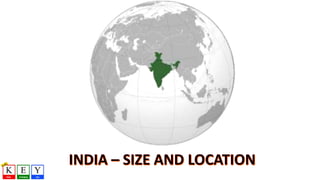
  • 103. Latitudes: 8 degree 4’ N and 37 degree 6’ N Longitudes: 68 degree 7’ E and 97 degree 25’ E India is divided into almost two equal parts by the Tropic of Cancer (23 degree 30’ N). Andaman and Nicobar Islands are situated towards the Southeast of the Indian mainland in the Bay of Bengal. Lakshadweep Islands are situated towards the Southwest of the Indian mainland in the Arabian Sea.
  • 104.
  • 105.
  • 106.
  • 107. 17.09 9.98 9.62 9.59 8.51 7.69 3.28 0 2 4 6 8 10 12 14 16 18 Russia Canada USA China Brazil Australia India Area of different countries Area(inmillionsq.km) Country
  • 108. 17.09 9.98 9.62 9.59 8.51 7.69 3.28 0 2 4 6 8 10 12 14 16 18 Russia Canada USA China Brazil Australia India Area of different countries Area(inmillionsq.km) Country
  • 110. Area Rest of the world India
  • 111.
  • 112.
  • 113.
  • 114.
  • 115.
  • 116.
  • 117.
  • 118.
  • 119.
  • 120.
  • 121.
  • 122.
  • 123.
  • 124.
  • 125.
  • 126.
  • 127.
  • 128.
  • 129.
  • 130.
  • 131.
  • 132.
  • 133.
  • 134.
  • 135.
  • 136.
  • 137.
  • 138.
  • 139.
  • 140.
  • 141.
  • 142.
  • 143.
  • 144.
  • 145.
  • 146.
  • 147.
  • 148.
  • 149.
  • 150.
  • 151.
  • 152.
  • 153.
  • 154.
  • 155.
  • 156. Maharishi Valmiki has recorded in his Ramayan- (Yuudh Kand, sarg 22 and shlokas 45-73) that Shri Rama’s army constructed a bridge over the sea between Rameswaram and Sri Lanka. After crossing this bridge, Shri Rama’s army reached Sri Lanka, defeated Ravana and liberated Sita from his captivity. It is found exactly at the location narrated in Valmiki Ramayan
  • 157. Space images taken by NASA reveal an ancient bridge in the Palk Strait between Bharat and Sri Lanka.
  • 158.
  • 159.
  • 160.
  • 161. The existence of the bridge obviously cannot be denied! However to what extent there was manual intervention in connecting the gaps between the shoals, islands and rocks is a subject for detailed marine archaeological and geological research. This kind of research has never been carried out nor has any team been constituted so far. However, there is enough evidence about the existence as well as the use of this bridge in ancient Bharatiya history, literature and travelogues etc. 'Ramayana', which mentions a bridge between Rameshwaram (Bharat) and the Sri- Lankan coast, constructed under the supervision of the dynamic and invincible figure of Rama, who is the incarnate of the supreme.
  • 162.
  • 163.
  • 164. Of the three major lines, Only Tropic of Cancer passes through India. Tropic of cancer passing through Indian states are as follows 1-Gujarat 2- Rajasthan 3- Madhaya Pradesh 4- Chattisgarh 5- Jharkhand 6- West Bengal 7- Tripura 8- Mizoram
  • 165.
  • 166.
  • 167.
  • 168. Tropic of Cancer board near Bhopal, India
  • 169.
  • 170. "KARK VRUT" a TROPIC OF CANCER passes here approch road to BHIRANDIARA - KHAVADA - KALODUNGAR of KUTCH.