
Empfohlen
Empfohlen
Weitere ähnliche Inhalte
Ähnlich wie Electoral maps
Ähnlich wie Electoral maps (20)
Kürzlich hochgeladen
Kürzlich hochgeladen (20)
Electoral maps
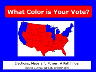
- 1. What Color is Your Vote? Elections, Maps and Power: A Pathfinder Melissa L. Jones, LIS 688, Summer 2008
- 2. Research Questions: •How are maps used by the general public during an election year? •How are maps used by candidates and political parties during an election year? •How do maps influence our votes?
- 3. In an election year, we use maps to… 1) Draw election districts
- 4. In an election year, we use maps to… 2) Follow polls and election results
- 5. In an election year, we use maps to… 3) Communicate information about winners and losers
- 6. In an election year, we use maps to… 4) Make sense of our national identity
- 9. Conclusions Election Maps in the media don’t reflect the complexity of our votes Maps play a large role in voter education Those with the power to manipulate our electoral map have the power to decide who gets elected You can play a role in making these decisions!
- 10. Conclusions Election Maps in the media don’t reflect the complexity of our votes Maps play a large role in voter education Those with the power to manipulate our electoral map have the power to decide who gets elected You can play a role in making these decisions!
Hinweis der Redaktion
- Hi, I’m Melissa and I’m a dork. For my project, I did something a little different. I decided to look at the theme of election maps. I started thinking about the red and blue map that we all look at on election night Misleading - looks like there are more red folks in the country than blue, right?
- Not only that, but this way of mapping election results serves to divide us, rather than bring us together. Are you an American, or a resident of Bushiana? Are you from the city or the country?Are you liberal or conservative?Religious or amoral? One of us or one of them? I wanted to find out how maps affect us in an election year. QUESTIONS In my research, which I compiled in a digital pathfinder, I found that there are four main reasons we use maps during an election year…
- Maps are used by local and state governments every year to redraw district boundaries… CLICK OVER TO SITE Show Digital Libraries Books (Monmonier) Electoral Geography They Represent Us
- HOLD UP Battle of Ballots - web 0.0 CLICK OVER TO SITE SHOW Web Apps - Web 2.0
- CLICK OVER TO SITE Show Websites
- CLICK OVER TO SITE Show Periodicals
- Is this who we are? Or is the picture more complex?CLICK OVER TO SITE Show Electoral Geography ATLASES
- Thank you! Yay!