2. (CRH) by Ates et al. (2003, 2008). In this paper, reduction to the pole
transformation (RTP) and second vertical derivative (SVD) methods
were performed on the aeromagnetic anomalies to investigate if any
spatial correlation with the faults of the region exists. SVD map
shows an indication of a major fault extending along Yalova,
Armutlu, Imrali and Edincik Faults. The Etili Fault is located to
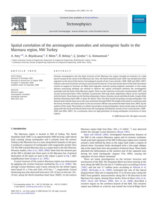
Fig. 1. Active fault map of the NW Turkey, modified from Saroglu et al. (1992). S-GF: Saros–Gazikoy Fault, EtF: Etili Fault, C-BFZ: Can-Biga Fault Zone, Y-GF: Yenice–Gonen Fault, SF:
Sarikoy Fault, EF: Edincik Fault, MF: Manyas Fault, UF: Ulubat Fault, NAF: North Anatolian Fault, AFl: Almacik Flake, ML: Manyas Lake, AL: Apolyan Lake, IL: Iznik Lake.
Fig. 2. Aeromagnetic anomaly map of the NW Turkey modified from Ates et al. (2003). Contour interval is 70 nT. Box shows the Marmara Sea region and this area are subjected to
further investigations as explained in the text. NMMA: North Marmara Magnetic Anomaly. AA' is the aeromagnetic anomaly profile.
136 A. Ateş et al. / Tectonophysics 478 (2009) 135–142
3. projection of these faults in the SW corner of the region. Total length
of these faults in complementary form exceeds 300 km and exhibits
earthquake hazard in connection with the seismological records of
this region. This fault zone is named the Major Fault Zone (MFZ) of
the NAF by the authors of this study.
2. Aeromagnetic data and interpretation
Residual aeromagnetic data of the region were obtained from the
General Directorate of Mineral Research and Exploration of Turkey (MTA).
Anomaly map of the study area was published previously by Ates et al.
Fig. 3. 2.5-Dimensional magnetic model along profile AA' shown in Fig. 2. Susceptibility of the magnetised body is taken 0.00315 cgs (SI) as described by Ates et al. (2008).
Fig. 4. Reduction to the pole transformation of the aeromagnetic anomalies in the area illustrated by the box in Fig. 2. Solid and broken arrows show possible fault propagation
directions. CRH: Central Ridge Horst, PI: Prince Islands, IA: Imrali Island.
137A. Ateş et al. / Tectonophysics 478 (2009) 135–142
4. Fig. 5. Image of the second vertical derivative of the aeromagnetic anomalies shown by the box in Fig. 2. NBF: Northern Boundary Fault, MFZ: Main Fault Zone.
Fig. 6. Earthquake distribution map of the region for the period between 1998 and 2002. Circle size shows the magnitude of the earthquake. CRH is the Central Ridge Horst defined in
the text as a resistive barrier. MFZ: Main Fault Zone, WTF: West Transform Fault, CTF: Cinarcik Transform Fault, NBF: Northern Boundary Fault, SBF: Southern Boundary Fault, EF:
Edincik Fault, YF: Yalova Fault, IF: Imrali Fault, MF: Manyas Fault, UF: Ulubat Fault, AF: Armutlu Fault, GM: Gemlik Fault, KP: Kapidag Peninsula, AL: Apolyan Lake, ML: Manyas Lake, IL:
Iznik Lake.
138 A. Ateş et al. / Tectonophysics 478 (2009) 135–142
5. (2003) and is given in Fig. 2. Grid interval of the data is 1×1 km. There are
several intensive aeromagnetic anomalies in the region. Anomalies along
the Black Sea coast are thought to be caused by the volcanic rocks and
these are not related to any faults. Magnetic anomaly along the E–W
direction in the north of the Marmara Sea can be related to northern
boundary Fault (NBF) of the NAF in the east and volcanic intrusions
alternating in sediments in the grabens of the Marmara Sea were defined
by Barka and Kadinsky-Cade (1988). There are series of anomalies to the
south of the region along the WSW–ENE direction. These anomalies are in
elliptical orcircular shapes and have distinct positive and negative contour
closures (Fig. 2). Thus, causative bodies of these anomalies are in different
character than the magnetised body in the north of the Marmara Sea. The
causative magnetic bodies are also related to the seismogenic faults of the
region. Tuncer et al. (1991) stated that magnetized bodies on the land area
to the east of the Marmara Sea filled the fractures of the faults. Ates et al.
(2003) produced 2.5-D models of the magnetic anomalies to the east of
the northern Marmara Sea. In this paper, one more 2.5-D magnetic model
was also produced (Fig. 3) along the north–south direction around Imrali
Island and it was indicated by the AA' (Fig. 2).
2.1. Reduction to the pole transformation
Reduction to the pole transformation of an anomaly in the Fourier
domain is given by Blakely (1995).
F ΔTrð Þ ¼ F Wr½ ŠF ΔTð Þ ð1Þ
Where F(ΔTr) is the Fourier transform of the RTP of an anomaly, F
(ΔT) is the Fourier transform of the magnetic field. Inverse Fourier
transform of this function is the reduction to the pole transformation
(RTP) of the anomaly and it is represented by
F Wr½ Š
1
ΘmΘf
¼
jkj2
a1k2
x þ a2k2
y þ a3kxky þ ijkj b1kx þ b2ky
À Á ; jkj≠0; ð2Þ
where
k ¼wavenumber
a1 ¼ ˆmz
ˆf z− ˆmx
ˆf x
a2 ¼ ˆmz
ˆf z− ˆmy
ˆf y
a3 ¼ − ˆmy
ˆf x− ˆmx
ˆfy
b1 ¼ ˆmx
ˆf z þ ˆmz
ˆfx
b2 ¼ ˆmy
ˆf z þ ˆmz
ˆfy
Θm and Θf are the functions representing the directions of the dipole
moment ˆm ¼ ˆmx; ˆmy; ˆmz
h i
and the ambient field ˆf ¼ ˆf x; ˆf y; ˆf z
h i
.
If m̂ˆ and f̂ˆ are vertical then the magnetized body is assumed to be at the
magnetic pole and thus this limitation is a priori condition for
transforming anomalies to the pole. The RTP transformation applied
anomaly map is given in Fig. 4. The inclination and declination angles of
theambient fieldweretakenas55°Nand4°E,respectively.IntheRTPmap,
most of the anomalies appear to have only positive contour closures. This
implies that most of the magnetized bodies have no or little
magnetization.
2.2. Second vertical derivative (SVD) of aeromagnetic anomalies
First order Fourier transformation of the potential field data is given
by Blakely (1995)
F
A/
Az
!
¼ jkjF /½ Š ð3Þ
where ϕ is the potential field data. Similarly, nth-order vertical
derivative can be given by
F
An
/
An
z
!
¼ jkjn
F /½ Š ð4Þ
Fig. 7. Earthquake distribution map of the region for the period between 2003 and 2007. Circle size shows the magnitude of the earthquake. Major tectonic feature names are the
same with Fig. 6.
139A. Ateş et al. / Tectonophysics 478 (2009) 135–142
6. Inverse Fourier transform of this function with n=2 is the second
vertical derivative (SVD). The second vertical derivative map is
illustrated in Fig. 5.
3. Seismogenic faults
Major faults of the region can be seen in Fig. 1. These are from east
to the west; Yalova, Armutlu, Imrali, Saros–Gazikoy, Etili, Can-Biga,
Yenice–Gonen, Sarikoy, Ulubat, Edincik and Manyas faults. Most of the
faults have normal components except the Cinarcik and Western
Transform faults seen in and around the Marmara Sea (Figs. 6 and 7).
3.1. Earthquake distribution
Seismological records were separated into two periods; first period
is between 1998 and 2002, second period is between 2003 and 2007.
They have good correlations with the existing faults in the region
(Fig. 1). Earthquake data were obtained from General Directorate of
Disaster Affairs of Turkey. The magnitude type is Md. A decrease of the
earthquake quantities (Figs. 6 and 7) can be observed on and around
the barrier named as the Central Ridge Horst (CRH) by Ates et al.
(2003). The number of earthquake occurrences was decreased by the
time. In the first 5 years between 1998 and 2002, the number of
earthquakes was 312. In the second 5 years between 2003 and 2007,
the number of earthquakes was 244. Especially, number of earth-
quakes in the range 4≤Mb5 decreased from 43 to 4 in the second
period. However, the number of M≥5 stayed in constant as 3 for the
two periods. On the other hand, the number of the range 3≤Mb4 also
decreased from 265 to 237 in the second period. Magnitude–
frequency histograms of these two periods are shown in Fig. 8.
Oncel and Wilson (2006) similarly described a resistive zone
around the same region. A seismic quiescence can be observed along
the Imrali and Edincik faults in the earthquake distribution maps
given in Figs. 6 and 7. Number of earthquakes increased in the western
Marmara region in the last period. This can be interpreted that the
seismic activity has been increasing more than the eastern Marmara
region. This situation is consistent with the characteristics of the
NAFZ.
4. Correlation of the aeromagnetic anomalies with faults
Second vertical derivate (SVD) map (Fig. 5) of the aeromagnetic
anomalies in the area is bounded by a rectangle in Fig. 2 and exhibits
similar alignments consistent with the active faults. These faults are
the Northern Boundary, Yalova, Armutlu, Imrali, Edincik and Etili
Faults. Length of the Northern Boundary Fault (NBF) is about 50–
60 km. Thus, this fault can not produce strong earthquakes than the
other faults mentioned above. Edincik and Etili Faults are situated
along the SW projection of the Imrali and Armutlu faults and bends
towards WSW. In this paper, these faults are named the Main Fault
Zone (MFZ) initially. The length of MFZ exceeds 300 km and these
faults may produce strong earthquakes. There is an E–W elongated
strike-slip fault parallel to the Bay of Gemlik towards the Kapidag
Peninsula (Figs. 6 and 7). This fault is also named the Gemlik Fault
(GF) for the first time by the authors of this study.
5. Discussion and conclusions
The Marmara Sea and its earthquake potential is important
because of its proximity to the city of Istanbul. Westernmost part of
the North Anatolian Fault (NAF) bifurcates into three parts in the Izmit
Bay and passes trough the region. Despite a lot of research, the nature,
structural complexity and movement of the NAF have not been
resolved properly and people living in Istanbul and its surroundings
are worried about an impending strong earthquake since the
devastating Izmit Earthquake in August 17th, 1999.
It was shown by Tuncer et al. (1991) that magnetized bodies
causing anomalies have good correlation with the faults in this area.
They suggested that the fractures of the faults were filled with
magmatic material depending on where the fault movement reaches
to magma. 2.5-D models in the east of the Marmara Sea showed an
existence of similar correlation with the magnetized bodies and
Fig. 8. Magnitude–Frequency histograms, (a) The period between 1998 and 2002, (b) The period between 2003 and 2007.
140 A. Ateş et al. / Tectonophysics 478 (2009) 135–142
7. seismogenic faults. In this paper, one more additional magnetic model
was constructed to show the correlation along the profile AA' in Fig. 2.
Magnetic model in Fig. 3 shows a magnetized body with its top on the
surface to down to a depth nearly 15 km. Reduction to the pole (RTP)
map (Fig. 4) displays interesting anomalies which can be correlated
with the active faults of the region. Direction of the faults were tried to
be followed by arrows. Second vertical derivative (SVD) map of the
aeromagnetic anomalies (Fig. 5) shows lineaments which can be
correlated with faults of the region. Two interesting lineaments are
outstanding. One of them is in the north and along with the Northern
Boundary Fault (NBF) and Cinarcik Transform Fault (CTF). The length
of this lineament is about 50–60 km (Fig. 9). Its continuation to the
west suddenly stops. It is interesting to observe from the earthquake
distribution maps for two 5 year periods (1998–2002 and 2003–2007)
that there is a seismic quiescence to the west (Figs. 6 and 7). This
seismically quiescent region coincides with the absence of any
lineaments in this region that was previously defined as the Central
Ridge Horst (CRH) by Ates et al. (2003, 2008). Seismic quiescence and
absence of any lineament are not fortuitous in this region, because a
rigid barrier restricts the fault movement in this area (Ates et al., 2003,
2008). Another, similar barrier also exists on the onshore to the east of
the Marmara Sea known as the Almacik Flake (AFl). The North
Anatolian Fault (NAF) was divided into two parts because of this
structure (Fig. 1). Palaeomagnetic studies showed that the Almacik
Flake (AFl) was rotated relatively in clockwise direction when Anatolia
was rotating in counter clockwise direction (Saribudak et al., 1990;
Michel et al., 1995).
The other interesting lineament exists in south. The Edincik Fault
extends from east to west and bends towards WSW. Imrali, Armutlu
and Yalova faults lie along the eastern projection of the Edincik fault
(Fig. 1). Saros–Gazikoy, Etili, Can-Biga, Yenice–Gonen and Sarikoy
faults are situated at the SW projection of these faults (Fig. 1). Total
length of these faults exceeds 300 km. We suggest that these faults in
the south constitute the Main Fault Zone (MFZ). Seismic gaps can be
observed around the cross point of the Imrali and Edincik faults on the
earthquake distribution maps. Thus, these regions should be con-
sidered as the places bearing high-potential for strong earthquake
occurrences. In Fig. 9 active fault zones are illustrated with the help of
the second vertical derivative of anomalies. As observed in Fig. 9 the
MFZ is located in the south. We suggest that future investigations
should be concentrated onto this zone.
Acknowledgements
We thank Dr. A. De Santis and the other three reviewers for
critically reviewing this manuscript and suggesting many helpful
comments. We also thank to Editor Dr. Kumar Hemant of NASA for his
delicate handling of this paper.
References
Alpar, B., Yaltirak, C., 2002. Characteristic features of the North Anatolian Fault in the
eastern Marmara region and its tectonic evolution. Mar. Geol. 190, 329–350.
Ates, A., Kayıran, T., Sincer, I., 2003. Structural interpretation of the Marmara Region,
NW Turkey from aeromagnetic, seismic and gravity data. Tectonophysics 367,
41–99.
Ates, A., Bilim, F., Buyuksarac, A., Bektas, O., 2008. A tectonic interpretation of the
Marmara Sea, NW Turkey from geophysical data. Earth Planets Space 60, 169–177.
Barka, A.A., 1992. The North Anatolian fault. Ann. Tecton. 6, 174–195.
Barka, A.A., Kadinsky-Cade, K., 1988. Strike-slip fault geometry in Turkey and its
influence on earthquake activity. Tectonics 7, 663–684.
Blakely, R.J., 1995. Potential theory in gravity and magnetic applications. Cambridge
University Press, UK, p. 441.
Ilkışık, O.M., 1995. Regional heat flow in western Anatolia using silica temperature
estimates from thermal springs. Tectonophysics 244, 175–184.
McClusky, S., Balassanian, S., Barka, A., Demir, C., Ergintav, S., Georgiev, I., Gurkan, O.,
Hamburger, M., Hurst, K., Kahle, H., Kastens, K., Kekelidze, G., King, R., Kotzev, V.,
Lenk, O., Mahmoud, S., Mishin, A., Nadariya, M., Ouzounis, A., Paradissis, D., Peter, Y.,
Fig. 9. Tectonic lineaments are overlain by the second vertical derivative of the anomalies given in Fig. 6. Minimum contour value is −0.00013. Maximum contour value is 0.00012.
Regions shown by dashed lines are defined as the fault zones. NBF: Northern Boundary Fault. MFZ: Main Fault Zone.
141A. Ateş et al. / Tectonophysics 478 (2009) 135–142
8. Prilepin, M., Reilinger, R., Sanli, I., Seeger, H., Teableb, A., Toksoz, M.N., Veis, G., 2000.
Global positioning system constraints on plate kinematics and dynamics in the
Eastern Mediterranean and Caucasus. J. Geophys. Res. 105, 5695–5719.
Michel, G.W., Waldhör, M., Neugebauer, J., Appel, E., 1995. Sequential rotation of
stretching axes, and block rotations: a structural and paleomagnetic study along the
North Anatolian Fault. Tectonophysics 243, 97–118.
Oncel, A.O., Wilson, T., 2006. Evaluation of earthquake potential along the North
Anatolian Fault Zone in the Marmara Sea using comparisons of GPS strain and
seismotectonic parameters. Tectonophysics 418, 205–218.
Saribudak, M., Sanver, M., Sengor, A.M.C., Gorur, N., 1990. Paleomagnetic evidence for
substantial rotation of the Almacik flake within the North Anatolian Fault Zone, NW
Turkey. Geophys. J. Int. 102, 563–568.
Saroglu, F., Emre, O., Kuscu, I., 1992. 1/1,000,000 active fault map of Turkey. General
Directorate of Mineral Research and Exploration of Turkey, Ankara.
Tuncer, M.K., Oshiman, N., Baris, S., Kamaci, Z., Kaya, M.A., Isikara, A.M., Honkura, Y.,
1991. Further evidence for anomalous magnetic structure along the active fault in
western Turkey. J. Geomag. Geoelectr. 43, 937–950.
Yaltirak, C., Sakinc, M., Oktay, F.Y., 2000. Westward propagation of the North Anatolian
fault into the northern Aegean: timing and kinematics–comment and reply.
Geology 28, 187–189.
Zor, E., Ozalaybey, S., Gurbuz, C., 2006. The crustal structure of the eastern Marmara
region, Turkey by teleseismic receiver functions. Geophys. J. Int. 167, 213–222.
142 A. Ateş et al. / Tectonophysics 478 (2009) 135–142