The Inconvenient Realities of Protected Area Management in the Philippines
•Als PPT, PDF herunterladen•
1 gefällt mir•1,652 views

Commissioned in 2007 by the Conservation International to design the governance structure for the proposed Mt. Mantalingahan Protected Landscape
![Author’s disclosure ,[object Object],[object Object]](data:image/gif;base64,R0lGODlhAQABAIAAAAAAAP///yH5BAEAAAAALAAAAAABAAEAAAIBRAA7)
Empfohlen
Empfohlen
Weitere ähnliche Inhalte
Was ist angesagt?
Was ist angesagt? (20)
Andere mochten auch
Andere mochten auch (20)
Ähnlich wie The Inconvenient Realities of Protected Area Management in the Philippines
Ähnlich wie The Inconvenient Realities of Protected Area Management in the Philippines (20)
Mehr von No to mining in Palawan
Mehr von No to mining in Palawan (20)
Kürzlich hochgeladen
Kürzlich hochgeladen (20)
The Inconvenient Realities of Protected Area Management in the Philippines
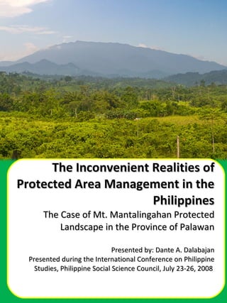
- 1. The Inconvenient Realities of Protected Area Management in the Philippines The Case of Mt. Mantalingahan Protected Landscape in the Province of Palawan Presented by: Dante A. Dalabajan Presented during the International Conference on Philippine Studies, Philippine Social Science Council, July 23-26, 2008
- 5. The recent discovery by scientists from Conservation International of a pouch bat, a pin-tail parrot finch, a ground orchid, and a soft-furred mountain rat—all hitherto little known to science—underscore the urgency of conserving the biodiversity of Mt. Mantalingahan Range. Pin-tailed Parrotfinch Erythrura prasina Soft-furred mountain rat Palawanomys furvus Terrestrial orchid Coelogyne sp.
- 8. Mt. Mantalingahan is the highest peak in Palawan at 2086 meters above sea level and the only remaining contiguous forest block in the province. On the eastern side are the Municipalities of Sofronio Espanola, Brooke’s Point and Bataraza; while Rizal and Quezon lie on the western side As of 1998, 64% of the total land area remains under forest cover, 75% is considered to be primary forest, and 25% secondary forest. The total area approved by the PCSD to be covered by the protected area is 126,348 has. covering 36 barangays.
- 29. 2001 1987
- 36. Mayad na adlaw at matamang salamat kanindong tanan.
Hinweis der Redaktion
- Proposal to institute protective mechanisms for MM dates as far back as the 1980s when……
- While advocates of MMPL is gaining, there are disquieting that threaten to suppress the their initial gains.
- EO270 was particularly significant because it marked the critical shift of government’s policy from tolerance to promotion of mining.
- Mt. Mantalingahan was particularly interesting to mining countries for obvious reason. It sits on top of ultramafics serpentized peridotite and dunite. That’s Greek for huge,huge mineral deposits.
- This map shows the various mining claims within the southern part of Palawan. But apparently, this is only the tip of the iceberg as the next map will show.
- This map is a confidential document from the DENR which indicate the mining claims.
- This headline is interesting
- Now let’s make a glimpse between 1997 and 2001. It doesn’t have to take a 20-20 vision to spot difference, does it?
- This map shows the overlay of the Celestial MPSA and the CADT application of the Pala’wan of Ma’asin.