Geographic scripting in uDig
•
6 gefällt mir•6,861 views

My presentation given at the Foss4g in Nottingham about geoscripting inside uDig.

Empfohlen
Empfohlen
Weitere ähnliche Inhalte
Was ist angesagt?
Was ist angesagt? (20)
Andere mochten auch
Andere mochten auch (20)
Ähnlich wie Geographic scripting in uDig
Ähnlich wie Geographic scripting in uDig (20)
Mehr von Andrea Antonello
Mehr von Andrea Antonello (20)
Kürzlich hochgeladen
Kürzlich hochgeladen (20)
Geographic scripting in uDig
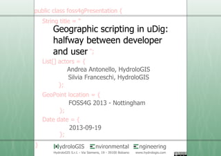
- 1. 1 /21 nvironmental ngineeringydroloGIS HydroloGIS S.r.l. - Via Siemens, 19 - 39100 Bolzano www.hydrologis.com Geographic scripting in uDig: halfway between developer and user FOSS4G 2013 - Nottingham Andrea Antonello, HydroloGIS Silvia Franceschi, HydroloGIS 2013-09-19
- 2. 2 /21 "Geographic scripting..." == Geoscript ...it adds spatial capabilities to scripting languages groovy scala javascript python clojure - bases on the geotools library - making development much simpler - simplicity, batch-ing for non developers - fast prototyping without compiling for developers
- 3. 3 /21 "Geographic scripting..." == Geoscript Through geotools it provides support for: vector data sources raster data sources various web services and databases projections vector geometry operations rendering - - - - - -
- 4. 4 /21 "Geographic scripting..." == Geoscript On what do we depend on? Java Advanced Imaging & Imageio-ext Geotools EMF JTS Java Topology Suite Geoscript
- 5. 5 /21 "Geographic scripting..." == Geoscript Java Advanced Imaging & Imageio-ext Geotools EMF JTS Java Topology Suite Deja vu! Geoscript uDig
- 6. 6 /21 "...in uDig" == Userfriendly Desktop Internet GIS uDig is an open source desktop GIS application framework, distributed under dual EPL and BSD license.
- 7. 7 /21 "...in uDig" == Userfriendly Desktop Internet GIS uDig is an open source desktop GIS application framework, distributed under dual EPL and BSD license.
- 8. 8 /21 "...in uDig" == Userfriendly Desktop Internet GIS uDig has a spatial toolbox to do spatial processing with the help of the jgrasstools project.
- 9. 9 /21 "...in uDig" == Userfriendly Desktop Internet GIS uDig is also an extensible GIS framework to create apps on
- 10. 10/21 The Scripting Editor in uDig: since 1.4.0 open the editor to create a new script
- 11. 11/21 The Scripting Editor in uDig: since 1.4.0 the scripting editor
- 12. 12/21 The Scripting Editor in uDig: since 1.4.0 run and stop scripts add common imports handle memory debug options have some fun
- 13. 13/21 Command completion (...ehm suggestion) minimal editor support without dynamic access to Java AST
- 14. 14/21 Syntax coloring basic syntax coloring
- 15. 15/21 Interaction with uDig Drag and drop support for file based data sources Access to uDig object model not available (at the moment)
- 16. 16/21 Running the script Each script is run in a different process scripts can be stopped output console choose memory wisely
- 18. 18/21 Hydro- Geomorphologic processing with JGrasstools By simply adding the JGrasstools jars to the "spatialtoolbox" folder in the uDig installation, the jgrasstools processing modules are enabled. - aspect - contour extraction - network extraction - slope - maximum discharge - lidar tools }just examples it is 0.1% of what you can do
- 19. 19/21 Hydro- Geomorphologic processing with JGrasstools Raster classes are enabled (now Geoscript also supports them)
- 20. 20/21 Hydro- Geomorphologic processing with JGrasstools JGrasstools supplies help for modules and syntax templates:
- 21. 21/21 Hydro- Geomorphologic processing with JGrasstools Templates just need to be filled:
- 22. 22/21 Hydro- Geomorphologic processing with JGrasstools Extract contours
- 23. 23/21 Hydro- Geomorphologic processing with JGrasstools More complex: extract river network from dtm
- 24. 24/21 Hydro- Geomorphologic processing with JGrasstools More complex: extract river network from dtm
- 25. 25/21 nvironmental ngineeringydroloGIS HydroloGIS S.r.l. - Via Siemens, 19 - 39100 Bolzano www.hydrologis.com Geoscript http://www.geoscript.org uDig http://www.udig.eu JGrasstools http://www.jgrasstools.org Geographic scripting in uDig: halfway between developer and user USEFUL LINKS