SlideShare ist ein Scribd-Unternehmen logo
1 von 56
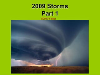
2009 StormsPart 1 ©2010 Fisher
Doppler Weather Radar Concepts ,[object Object]
Radar beam increases in size with distance from radar.
Radar takes 4-5 minutes to complete full scan when in storm/precip mode.
Reliable doppler wind data limited to about 60-70 nm.
Radar velocity 100% when parallel, 0% when perpendicular to beam direction.,[object Object]
Products Base reflectivity  how much precipitation is falling  precipitation type assess a storm's structure and dimension Composite Reflectivity Scans from all elevations, imaging precipitation intensity and storm structure Base Velocity radial wind field, speed of fronts/strong wind range of 140 mi Storm relative motion Track a circulation (show up well in doppler return) over time to determine storm motion. Removing the storm relative motion from base radials gives an estimate of the flow with respect to the storm.
LOT Height of beam above ground vs distance from radar.  Green  10nm Yellow 15nm Red      20nm
ORD         TDWR 20nm 10nm
MDW TDWR 20nm 10nm
What is a supercell? Storms having deep, persistent, rotation about a vertical axis
What is a supercell? What are the biggest unanswered questions in the study of tornadogenesis? Why do storms with seemingly similar structure differ in their tornado production? Although most significant tornadoes are associated with supercell thunderstorms, most supercells are nottornadic What’s perhaps most troubling (from the perspective of issuing warnings) is that most supercells contain low-level mesocyclones, and perhaps most supercells even have circulations that extend to the surface nontornadic nontornadic nontornadic tornadic
April 9, 2009 day 1 of 2 day storm outbreak 5PM 0-6 km Shear Vector
0-3 km
0-1 km
0-1 km
KSRX Vad Winds
Storm Composite
Base Reflectivity lvl 2
Storm Relative Velocity lvl 2
Base Velocity lvl 2
April 10, 2009 2nd day of outbreak 2 PM 0-6 km Shear Vector
Storm Composite
Radar HTX Base Reflectivity lvl 2 ~ 1500 ft Classic Rotating Supercell
Radar HTX Storm Relative Velocity lvl 2 Strong Rotation Couplet
Radar HTX Base Reflectivity lvl 2 ~ 3200 ft
Radar HTX
 HTX Base Reflectivity lvl 2 ~ 1900 ft  0.5˚
 HTX Storm Relative Velocity  lvl 2 ~ 1900 ft  0.5˚ Double Rotation?
 HTX Base Reflectivity lvl 2 ~ 4000 ft  1.3˚  Bowing Line Tstms (L) and Classic Supercell (R)
 HTX Base Velocity  lvl 2 ~ 1900 ft 0.5˚
 HTX Storm Relative Velocity  lvl 2 ~ 4000 ft  1.3˚ Downburst (L) and Rotation Couplet (R)
Part of 5/8/09 Derecho 100+ mph S IL, 5 dead in MO/ KY
Tornadogenesis:  Three ingredients 1 Development of a persistent, rotating updraft 2 Ingestion of enhanced SRH (occasionally, large-scale SRH is sufficient) and development of strong low-level rotation 3 Development of a downdraft partially embedded in the rotation that aids in the transport of rotation to the ground, followed by focusing of that rotation through convergence if the downdraft reaches the ground with some very uncommon properties
Tornadogenesis in a Nutshell
The Need for Better Understanding of Tornadic Storms Tornado warnings Improvements in our understanding of tornadogenesis should better allow us to assess the likelihood of tornadoes in thunderstorms Possible advances in our ability to forecast tornado intensity and longevity Improvements likely due to 88D network, better training, better SPC guidance, application of VORTEX1 findings? Tornado warning performance from 1986-2002 (adapted from Brooks 2004)
Summary (what we know) ,[object Object]
Although most significant tornadoes are associated with supercell thunderstorms, most supercells are not tornadic (and the supercells with the strongest mesocyclones are not necessarily the most likely to be tornadic)
Tornadogenesis requires a downdraft if pre-existing vertical vorticity is absent at the surface
The temperature of the downdrafts seems to be important to tornadogenesis; downdrafts that are excessively cold apparently are unfavorable for tornadogenesis
Environments that have large ambient low-level vertical wind shear (larger than what is found in an average supercell environment) and large ambient relative humidity favor tornadic supercells over nontornadic supercells,[object Object]
LSXReflectivity lvl 2

Weitere ähnliche Inhalte

Was ist angesagt?

Space wave propagation ppt
Space wave propagation pptSpace wave propagation ppt
Space wave propagation pptdhanesh1994
 
Electromagnetic Wave propagation, Electromagnetic
Electromagnetic Wave propagation, ElectromagneticElectromagnetic Wave propagation, Electromagnetic
Electromagnetic Wave propagation, ElectromagneticMuhammad Ibrahim
 
Radio Wave propagation
Radio Wave propagationRadio Wave propagation
Radio Wave propagationRitika De
 
Luminaire Light Distribution Classifications
Luminaire Light Distribution ClassificationsLuminaire Light Distribution Classifications
Luminaire Light Distribution ClassificationsMorgan Catha
 
Chap 02 antenna & wave propagation
Chap 02 antenna & wave propagation Chap 02 antenna & wave propagation
Chap 02 antenna & wave propagation EngkaderAMuse
 
Stormlab Radar Software
Stormlab Radar SoftwareStormlab Radar Software
Stormlab Radar Softwaremjspieglan
 
Electromagnetic waves
Electromagnetic wavesElectromagnetic waves
Electromagnetic wavesKANNAN
 
Lecture2 antennas and propagation
Lecture2 antennas and propagationLecture2 antennas and propagation
Lecture2 antennas and propagationYahya Alzidi
 
Rf and mw radiation hazards
Rf and mw radiation hazardsRf and mw radiation hazards
Rf and mw radiation hazardsShankar Gangaju
 
2009 Storms, Part 2
2009 Storms, Part 22009 Storms, Part 2
2009 Storms, Part 2mjspieglan
 
Electromagnetic spectrum,
Electromagnetic spectrum, Electromagnetic spectrum,
Electromagnetic spectrum, Joy Sison
 
Tsunami warning system
Tsunami warning systemTsunami warning system
Tsunami warning systemVineet Yadav
 
Electromagnetic spectrum
Electromagnetic spectrumElectromagnetic spectrum
Electromagnetic spectrumBen Ostrow
 

Was ist angesagt? (20)

Space wave propagation ppt
Space wave propagation pptSpace wave propagation ppt
Space wave propagation ppt
 
Emw
EmwEmw
Emw
 
radio propagation
radio propagationradio propagation
radio propagation
 
Electromagnetic Wave propagation, Electromagnetic
Electromagnetic Wave propagation, ElectromagneticElectromagnetic Wave propagation, Electromagnetic
Electromagnetic Wave propagation, Electromagnetic
 
Radio waves
Radio wavesRadio waves
Radio waves
 
Radio Wave propagation
Radio Wave propagationRadio Wave propagation
Radio Wave propagation
 
Luminaire Light Distribution Classifications
Luminaire Light Distribution ClassificationsLuminaire Light Distribution Classifications
Luminaire Light Distribution Classifications
 
Radio
RadioRadio
Radio
 
Chap 02 antenna & wave propagation
Chap 02 antenna & wave propagation Chap 02 antenna & wave propagation
Chap 02 antenna & wave propagation
 
Ec 8701 ame unit 1
Ec 8701 ame unit 1Ec 8701 ame unit 1
Ec 8701 ame unit 1
 
Electromagnetic spectrum
Electromagnetic spectrumElectromagnetic spectrum
Electromagnetic spectrum
 
Stormlab Radar Software
Stormlab Radar SoftwareStormlab Radar Software
Stormlab Radar Software
 
Electromagnetic waves
Electromagnetic wavesElectromagnetic waves
Electromagnetic waves
 
Lecture2 antennas and propagation
Lecture2 antennas and propagationLecture2 antennas and propagation
Lecture2 antennas and propagation
 
Rf and mw radiation hazards
Rf and mw radiation hazardsRf and mw radiation hazards
Rf and mw radiation hazards
 
2009 Storms, Part 2
2009 Storms, Part 22009 Storms, Part 2
2009 Storms, Part 2
 
Microwave 1st class
Microwave 1st classMicrowave 1st class
Microwave 1st class
 
Electromagnetic spectrum,
Electromagnetic spectrum, Electromagnetic spectrum,
Electromagnetic spectrum,
 
Tsunami warning system
Tsunami warning systemTsunami warning system
Tsunami warning system
 
Electromagnetic spectrum
Electromagnetic spectrumElectromagnetic spectrum
Electromagnetic spectrum
 

Andere mochten auch

2009 Storms, Part 3
2009 Storms, Part 32009 Storms, Part 3
2009 Storms, Part 3mjspieglan
 
Towards an adverse event reporting ontology
Towards an adverse event reporting ontologyTowards an adverse event reporting ontology
Towards an adverse event reporting ontologyMelanie Courtot
 
MJH STaR Chart
MJH STaR ChartMJH STaR Chart
MJH STaR Chartconstance
 
Randy Pausch on Time Management
Randy Pausch on Time ManagementRandy Pausch on Time Management
Randy Pausch on Time Managementmjspieglan
 
PHAC/CIHR Influenza Research Network
PHAC/CIHR Influenza Research NetworkPHAC/CIHR Influenza Research Network
PHAC/CIHR Influenza Research NetworkMelanie Courtot
 

Andere mochten auch (7)

ICBO2012 Flash talk
ICBO2012 Flash talkICBO2012 Flash talk
ICBO2012 Flash talk
 
2009 Storms, Part 3
2009 Storms, Part 32009 Storms, Part 3
2009 Storms, Part 3
 
Towards an adverse event reporting ontology
Towards an adverse event reporting ontologyTowards an adverse event reporting ontology
Towards an adverse event reporting ontology
 
MJH STaR Chart
MJH STaR ChartMJH STaR Chart
MJH STaR Chart
 
Randy Pausch on Time Management
Randy Pausch on Time ManagementRandy Pausch on Time Management
Randy Pausch on Time Management
 
PHAC/CIHR Influenza Research Network
PHAC/CIHR Influenza Research NetworkPHAC/CIHR Influenza Research Network
PHAC/CIHR Influenza Research Network
 
Mkv轉Rmvb
Mkv轉RmvbMkv轉Rmvb
Mkv轉Rmvb
 

Ähnlich wie 2009 Storms, Part 1

Kansas City Ams 12 Feb2009
Kansas City Ams 12 Feb2009Kansas City Ams 12 Feb2009
Kansas City Ams 12 Feb2009guest9645d5a
 
Kansas City Ams 12 Feb2009 Evan
Kansas City Ams 12 Feb2009 EvanKansas City Ams 12 Feb2009 Evan
Kansas City Ams 12 Feb2009 Evanduker3100
 
Radar 2009 a 10 radar clutter.2pdf
Radar 2009 a 10 radar clutter.2pdfRadar 2009 a 10 radar clutter.2pdf
Radar 2009 a 10 radar clutter.2pdfForward2025
 
radar-principles
radar-principlesradar-principles
radar-principlesjhcid
 
Fukao Plenary.ppt
Fukao Plenary.pptFukao Plenary.ppt
Fukao Plenary.pptgrssieee
 
TU4.T10.4.pptx
TU4.T10.4.pptxTU4.T10.4.pptx
TU4.T10.4.pptxgrssieee
 
Convective storms in Europe: a look back at COPS and CSIP
Convective storms in Europe: a look back at COPS and CSIPConvective storms in Europe: a look back at COPS and CSIP
Convective storms in Europe: a look back at COPS and CSIPAndrew Russell
 
Some basic concepts
Some basic conceptsSome basic concepts
Some basic conceptsJamal Ahmad
 
HollingsPresentation
HollingsPresentationHollingsPresentation
HollingsPresentationTrenton Davis
 
Fukao Plenary4.pdf
Fukao Plenary4.pdfFukao Plenary4.pdf
Fukao Plenary4.pdfnickohrn
 
Fukao Plenary4.pdf
Fukao Plenary4.pdfFukao Plenary4.pdf
Fukao Plenary4.pdfgrssieee
 
04 Mmitt 040599 Brief
04 Mmitt 040599 Brief04 Mmitt 040599 Brief
04 Mmitt 040599 Briefguest02f352
 
Stationary waves and slowly moving features in the night upper clouds of Venus
Stationary waves and slowly moving features in the night upper clouds of VenusStationary waves and slowly moving features in the night upper clouds of Venus
Stationary waves and slowly moving features in the night upper clouds of VenusSérgio Sacani
 
Surveying ii ajith sir class5
Surveying ii ajith sir class5Surveying ii ajith sir class5
Surveying ii ajith sir class5SHAMJITH KM
 

Ähnlich wie 2009 Storms, Part 1 (20)

Kansas City Ams 12 Feb2009
Kansas City Ams 12 Feb2009Kansas City Ams 12 Feb2009
Kansas City Ams 12 Feb2009
 
Kansas City Ams 12 Feb2009 Evan
Kansas City Ams 12 Feb2009 EvanKansas City Ams 12 Feb2009 Evan
Kansas City Ams 12 Feb2009 Evan
 
The Nature of Mother Nature
The Nature of Mother NatureThe Nature of Mother Nature
The Nature of Mother Nature
 
MEA
MEAMEA
MEA
 
Radar 2009 a 10 radar clutter.2pdf
Radar 2009 a 10 radar clutter.2pdfRadar 2009 a 10 radar clutter.2pdf
Radar 2009 a 10 radar clutter.2pdf
 
radar-principles
radar-principlesradar-principles
radar-principles
 
Fukao Plenary.ppt
Fukao Plenary.pptFukao Plenary.ppt
Fukao Plenary.ppt
 
PPT.ppt
PPT.pptPPT.ppt
PPT.ppt
 
Propagation effects and their impact on satellite earth links
Propagation effects and their impact on satellite earth linksPropagation effects and their impact on satellite earth links
Propagation effects and their impact on satellite earth links
 
TU4.T10.4.pptx
TU4.T10.4.pptxTU4.T10.4.pptx
TU4.T10.4.pptx
 
Convective storms in Europe: a look back at COPS and CSIP
Convective storms in Europe: a look back at COPS and CSIPConvective storms in Europe: a look back at COPS and CSIP
Convective storms in Europe: a look back at COPS and CSIP
 
Some basic concepts
Some basic conceptsSome basic concepts
Some basic concepts
 
HollingsPresentation
HollingsPresentationHollingsPresentation
HollingsPresentation
 
Fukao Plenary4.pdf
Fukao Plenary4.pdfFukao Plenary4.pdf
Fukao Plenary4.pdf
 
Fukao Plenary4.pdf
Fukao Plenary4.pdfFukao Plenary4.pdf
Fukao Plenary4.pdf
 
Radar presentation
Radar presentation Radar presentation
Radar presentation
 
04 Mmitt 040599 Brief
04 Mmitt 040599 Brief04 Mmitt 040599 Brief
04 Mmitt 040599 Brief
 
Stationary waves and slowly moving features in the night upper clouds of Venus
Stationary waves and slowly moving features in the night upper clouds of VenusStationary waves and slowly moving features in the night upper clouds of Venus
Stationary waves and slowly moving features in the night upper clouds of Venus
 
Wind Energy
Wind EnergyWind Energy
Wind Energy
 
Surveying ii ajith sir class5
Surveying ii ajith sir class5Surveying ii ajith sir class5
Surveying ii ajith sir class5
 

Kürzlich hochgeladen

Boost Fertility New Invention Ups Success Rates.pdf
Boost Fertility New Invention Ups Success Rates.pdfBoost Fertility New Invention Ups Success Rates.pdf
Boost Fertility New Invention Ups Success Rates.pdfsudhanshuwaghmare1
 
Strategies for Landing an Oracle DBA Job as a Fresher
Strategies for Landing an Oracle DBA Job as a FresherStrategies for Landing an Oracle DBA Job as a Fresher
Strategies for Landing an Oracle DBA Job as a FresherRemote DBA Services
 
Boost PC performance: How more available memory can improve productivity
Boost PC performance: How more available memory can improve productivityBoost PC performance: How more available memory can improve productivity
Boost PC performance: How more available memory can improve productivityPrincipled Technologies
 
A Domino Admins Adventures (Engage 2024)
A Domino Admins Adventures (Engage 2024)A Domino Admins Adventures (Engage 2024)
A Domino Admins Adventures (Engage 2024)Gabriella Davis
 
ProductAnonymous-April2024-WinProductDiscovery-MelissaKlemke
ProductAnonymous-April2024-WinProductDiscovery-MelissaKlemkeProductAnonymous-April2024-WinProductDiscovery-MelissaKlemke
ProductAnonymous-April2024-WinProductDiscovery-MelissaKlemkeProduct Anonymous
 
Tata AIG General Insurance Company - Insurer Innovation Award 2024
Tata AIG General Insurance Company - Insurer Innovation Award 2024Tata AIG General Insurance Company - Insurer Innovation Award 2024
Tata AIG General Insurance Company - Insurer Innovation Award 2024The Digital Insurer
 
Bajaj Allianz Life Insurance Company - Insurer Innovation Award 2024
Bajaj Allianz Life Insurance Company - Insurer Innovation Award 2024Bajaj Allianz Life Insurance Company - Insurer Innovation Award 2024
Bajaj Allianz Life Insurance Company - Insurer Innovation Award 2024The Digital Insurer
 
Scaling API-first – The story of a global engineering organization
Scaling API-first – The story of a global engineering organizationScaling API-first – The story of a global engineering organization
Scaling API-first – The story of a global engineering organizationRadu Cotescu
 
GenAI Risks & Security Meetup 01052024.pdf
GenAI Risks & Security Meetup 01052024.pdfGenAI Risks & Security Meetup 01052024.pdf
GenAI Risks & Security Meetup 01052024.pdflior mazor
 
TrustArc Webinar - Unlock the Power of AI-Driven Data Discovery
TrustArc Webinar - Unlock the Power of AI-Driven Data DiscoveryTrustArc Webinar - Unlock the Power of AI-Driven Data Discovery
TrustArc Webinar - Unlock the Power of AI-Driven Data DiscoveryTrustArc
 
The 7 Things I Know About Cyber Security After 25 Years | April 2024
The 7 Things I Know About Cyber Security After 25 Years | April 2024The 7 Things I Know About Cyber Security After 25 Years | April 2024
The 7 Things I Know About Cyber Security After 25 Years | April 2024Rafal Los
 
Powerful Google developer tools for immediate impact! (2023-24 C)
Powerful Google developer tools for immediate impact! (2023-24 C)Powerful Google developer tools for immediate impact! (2023-24 C)
Powerful Google developer tools for immediate impact! (2023-24 C)wesley chun
 
Understanding Discord NSFW Servers A Guide for Responsible Users.pdf
Understanding Discord NSFW Servers A Guide for Responsible Users.pdfUnderstanding Discord NSFW Servers A Guide for Responsible Users.pdf
Understanding Discord NSFW Servers A Guide for Responsible Users.pdfUK Journal
 
Handwritten Text Recognition for manuscripts and early printed texts
Handwritten Text Recognition for manuscripts and early printed textsHandwritten Text Recognition for manuscripts and early printed texts
Handwritten Text Recognition for manuscripts and early printed textsMaria Levchenko
 
Exploring the Future Potential of AI-Enabled Smartphone Processors
Exploring the Future Potential of AI-Enabled Smartphone ProcessorsExploring the Future Potential of AI-Enabled Smartphone Processors
Exploring the Future Potential of AI-Enabled Smartphone Processorsdebabhi2
 
[2024]Digital Global Overview Report 2024 Meltwater.pdf
[2024]Digital Global Overview Report 2024 Meltwater.pdf[2024]Digital Global Overview Report 2024 Meltwater.pdf
[2024]Digital Global Overview Report 2024 Meltwater.pdfhans926745
 
Automating Google Workspace (GWS) & more with Apps Script
Automating Google Workspace (GWS) & more with Apps ScriptAutomating Google Workspace (GWS) & more with Apps Script
Automating Google Workspace (GWS) & more with Apps Scriptwesley chun
 
🐬 The future of MySQL is Postgres 🐘
🐬  The future of MySQL is Postgres   🐘🐬  The future of MySQL is Postgres   🐘
🐬 The future of MySQL is Postgres 🐘RTylerCroy
 
Strategize a Smooth Tenant-to-tenant Migration and Copilot Takeoff
Strategize a Smooth Tenant-to-tenant Migration and Copilot TakeoffStrategize a Smooth Tenant-to-tenant Migration and Copilot Takeoff
Strategize a Smooth Tenant-to-tenant Migration and Copilot Takeoffsammart93
 

Kürzlich hochgeladen (20)

Boost Fertility New Invention Ups Success Rates.pdf
Boost Fertility New Invention Ups Success Rates.pdfBoost Fertility New Invention Ups Success Rates.pdf
Boost Fertility New Invention Ups Success Rates.pdf
 
Strategies for Landing an Oracle DBA Job as a Fresher
Strategies for Landing an Oracle DBA Job as a FresherStrategies for Landing an Oracle DBA Job as a Fresher
Strategies for Landing an Oracle DBA Job as a Fresher
 
Boost PC performance: How more available memory can improve productivity
Boost PC performance: How more available memory can improve productivityBoost PC performance: How more available memory can improve productivity
Boost PC performance: How more available memory can improve productivity
 
A Domino Admins Adventures (Engage 2024)
A Domino Admins Adventures (Engage 2024)A Domino Admins Adventures (Engage 2024)
A Domino Admins Adventures (Engage 2024)
 
ProductAnonymous-April2024-WinProductDiscovery-MelissaKlemke
ProductAnonymous-April2024-WinProductDiscovery-MelissaKlemkeProductAnonymous-April2024-WinProductDiscovery-MelissaKlemke
ProductAnonymous-April2024-WinProductDiscovery-MelissaKlemke
 
Tata AIG General Insurance Company - Insurer Innovation Award 2024
Tata AIG General Insurance Company - Insurer Innovation Award 2024Tata AIG General Insurance Company - Insurer Innovation Award 2024
Tata AIG General Insurance Company - Insurer Innovation Award 2024
 
Bajaj Allianz Life Insurance Company - Insurer Innovation Award 2024
Bajaj Allianz Life Insurance Company - Insurer Innovation Award 2024Bajaj Allianz Life Insurance Company - Insurer Innovation Award 2024
Bajaj Allianz Life Insurance Company - Insurer Innovation Award 2024
 
Scaling API-first – The story of a global engineering organization
Scaling API-first – The story of a global engineering organizationScaling API-first – The story of a global engineering organization
Scaling API-first – The story of a global engineering organization
 
GenAI Risks & Security Meetup 01052024.pdf
GenAI Risks & Security Meetup 01052024.pdfGenAI Risks & Security Meetup 01052024.pdf
GenAI Risks & Security Meetup 01052024.pdf
 
TrustArc Webinar - Unlock the Power of AI-Driven Data Discovery
TrustArc Webinar - Unlock the Power of AI-Driven Data DiscoveryTrustArc Webinar - Unlock the Power of AI-Driven Data Discovery
TrustArc Webinar - Unlock the Power of AI-Driven Data Discovery
 
The 7 Things I Know About Cyber Security After 25 Years | April 2024
The 7 Things I Know About Cyber Security After 25 Years | April 2024The 7 Things I Know About Cyber Security After 25 Years | April 2024
The 7 Things I Know About Cyber Security After 25 Years | April 2024
 
Powerful Google developer tools for immediate impact! (2023-24 C)
Powerful Google developer tools for immediate impact! (2023-24 C)Powerful Google developer tools for immediate impact! (2023-24 C)
Powerful Google developer tools for immediate impact! (2023-24 C)
 
Understanding Discord NSFW Servers A Guide for Responsible Users.pdf
Understanding Discord NSFW Servers A Guide for Responsible Users.pdfUnderstanding Discord NSFW Servers A Guide for Responsible Users.pdf
Understanding Discord NSFW Servers A Guide for Responsible Users.pdf
 
Handwritten Text Recognition for manuscripts and early printed texts
Handwritten Text Recognition for manuscripts and early printed textsHandwritten Text Recognition for manuscripts and early printed texts
Handwritten Text Recognition for manuscripts and early printed texts
 
+971581248768>> SAFE AND ORIGINAL ABORTION PILLS FOR SALE IN DUBAI AND ABUDHA...
+971581248768>> SAFE AND ORIGINAL ABORTION PILLS FOR SALE IN DUBAI AND ABUDHA...+971581248768>> SAFE AND ORIGINAL ABORTION PILLS FOR SALE IN DUBAI AND ABUDHA...
+971581248768>> SAFE AND ORIGINAL ABORTION PILLS FOR SALE IN DUBAI AND ABUDHA...
 
Exploring the Future Potential of AI-Enabled Smartphone Processors
Exploring the Future Potential of AI-Enabled Smartphone ProcessorsExploring the Future Potential of AI-Enabled Smartphone Processors
Exploring the Future Potential of AI-Enabled Smartphone Processors
 
[2024]Digital Global Overview Report 2024 Meltwater.pdf
[2024]Digital Global Overview Report 2024 Meltwater.pdf[2024]Digital Global Overview Report 2024 Meltwater.pdf
[2024]Digital Global Overview Report 2024 Meltwater.pdf
 
Automating Google Workspace (GWS) & more with Apps Script
Automating Google Workspace (GWS) & more with Apps ScriptAutomating Google Workspace (GWS) & more with Apps Script
Automating Google Workspace (GWS) & more with Apps Script
 
🐬 The future of MySQL is Postgres 🐘
🐬  The future of MySQL is Postgres   🐘🐬  The future of MySQL is Postgres   🐘
🐬 The future of MySQL is Postgres 🐘
 
Strategize a Smooth Tenant-to-tenant Migration and Copilot Takeoff
Strategize a Smooth Tenant-to-tenant Migration and Copilot TakeoffStrategize a Smooth Tenant-to-tenant Migration and Copilot Takeoff
Strategize a Smooth Tenant-to-tenant Migration and Copilot Takeoff
 

2009 Storms, Part 1

  • 1. 2009 StormsPart 1 ©2010 Fisher
  • 2.
  • 3. Radar beam increases in size with distance from radar.
  • 4. Radar takes 4-5 minutes to complete full scan when in storm/precip mode.
  • 5. Reliable doppler wind data limited to about 60-70 nm.
  • 6.
  • 7. Products Base reflectivity how much precipitation is falling precipitation type assess a storm's structure and dimension Composite Reflectivity Scans from all elevations, imaging precipitation intensity and storm structure Base Velocity radial wind field, speed of fronts/strong wind range of 140 mi Storm relative motion Track a circulation (show up well in doppler return) over time to determine storm motion. Removing the storm relative motion from base radials gives an estimate of the flow with respect to the storm.
  • 8. LOT Height of beam above ground vs distance from radar. Green 10nm Yellow 15nm Red 20nm
  • 9. ORD TDWR 20nm 10nm
  • 11. What is a supercell? Storms having deep, persistent, rotation about a vertical axis
  • 12. What is a supercell? What are the biggest unanswered questions in the study of tornadogenesis? Why do storms with seemingly similar structure differ in their tornado production? Although most significant tornadoes are associated with supercell thunderstorms, most supercells are nottornadic What’s perhaps most troubling (from the perspective of issuing warnings) is that most supercells contain low-level mesocyclones, and perhaps most supercells even have circulations that extend to the surface nontornadic nontornadic nontornadic tornadic
  • 13. April 9, 2009 day 1 of 2 day storm outbreak 5PM 0-6 km Shear Vector
  • 17.
  • 18.
  • 19.
  • 20.
  • 26.
  • 27. April 10, 2009 2nd day of outbreak 2 PM 0-6 km Shear Vector
  • 28.
  • 29.
  • 30.
  • 31.
  • 32.
  • 33.
  • 35. Radar HTX Base Reflectivity lvl 2 ~ 1500 ft Classic Rotating Supercell
  • 36. Radar HTX Storm Relative Velocity lvl 2 Strong Rotation Couplet
  • 37. Radar HTX Base Reflectivity lvl 2 ~ 3200 ft
  • 39. HTX Base Reflectivity lvl 2 ~ 1900 ft 0.5˚
  • 40. HTX Storm Relative Velocity lvl 2 ~ 1900 ft 0.5˚ Double Rotation?
  • 41. HTX Base Reflectivity lvl 2 ~ 4000 ft 1.3˚ Bowing Line Tstms (L) and Classic Supercell (R)
  • 42. HTX Base Velocity lvl 2 ~ 1900 ft 0.5˚
  • 43. HTX Storm Relative Velocity lvl 2 ~ 4000 ft 1.3˚ Downburst (L) and Rotation Couplet (R)
  • 44. Part of 5/8/09 Derecho 100+ mph S IL, 5 dead in MO/ KY
  • 45.
  • 46.
  • 47.
  • 48. Tornadogenesis: Three ingredients 1 Development of a persistent, rotating updraft 2 Ingestion of enhanced SRH (occasionally, large-scale SRH is sufficient) and development of strong low-level rotation 3 Development of a downdraft partially embedded in the rotation that aids in the transport of rotation to the ground, followed by focusing of that rotation through convergence if the downdraft reaches the ground with some very uncommon properties
  • 50. The Need for Better Understanding of Tornadic Storms Tornado warnings Improvements in our understanding of tornadogenesis should better allow us to assess the likelihood of tornadoes in thunderstorms Possible advances in our ability to forecast tornado intensity and longevity Improvements likely due to 88D network, better training, better SPC guidance, application of VORTEX1 findings? Tornado warning performance from 1986-2002 (adapted from Brooks 2004)
  • 51.
  • 52. Although most significant tornadoes are associated with supercell thunderstorms, most supercells are not tornadic (and the supercells with the strongest mesocyclones are not necessarily the most likely to be tornadic)
  • 53. Tornadogenesis requires a downdraft if pre-existing vertical vorticity is absent at the surface
  • 54. The temperature of the downdrafts seems to be important to tornadogenesis; downdrafts that are excessively cold apparently are unfavorable for tornadogenesis
  • 55.
  • 58. Storm Relative Velocity lvl 2 Tornado warning?
  • 59.
  • 60.
  • 61.