Interoperability in Cultural Heritage: beyond GIS
•
0 gefällt mir•532 views

Winning poster GSDI 11 world Conference june 15-19 2009 Rotterdam.
Empfohlen

Empfohlen
Weitere ähnliche Inhalte
Andere mochten auch
Andere mochten auch (8)
Mehr von platform meta-informatie
Mehr von platform meta-informatie (19)
Kürzlich hochgeladen
Kürzlich hochgeladen (20)
Interoperability in Cultural Heritage: beyond GIS
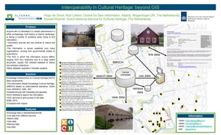
- 1. Interoperability in Cultural Heritage: beyond GIS Hugo de Groot, Rob Lokers: Centre for Geo-Information, Alterra, Wageningen UR, The Netherlands; Ronald Wiemer: Dutch National Service for Cultural Heritage, The Netherlands. Problem Anyone who is interested in a certain phenomenon in datasources either archaeology, built history or historic landscape, is facing a number of problems when trying to find information: • Information sources are very diverse of nature and quality. •The information is stored scattered over many organisations, varying from governmental bodies to local NGO’s. link data •The form in which the information occurs differs: ranging from very extensive and to a large extent structured, usually GIS oriented datasets to mainly IMKICH documentary collections. •Many datasets originate in thematic projects. Central Solution (meta)data search data use data Knowledge Infrastructure on Cultural Heritage (KICH) Main components: •The Information Model Knowledge Cultural Heritage. (IMKICH) Based on (inter)national standards. Dublin Core, NEN3610, GML, ISO. retrieve •Datawarehouse with metadata and geodata. data •KICH Website to search the information. •OGC services to give access to the data. view data WMS, WFS. •Compliant with Inspire Features •Exchange data in standardised format. •Link data from different sources. Information •Search data. •View data. mailto: hugo.degroot@wur.nl •Retrieve data mailto: rob.lokers@wur.nl •Use data mailto: r.wiemer@cultureelerfgoed.nl web: www.kich.nl