
Empfohlen
Weitere ähnliche Inhalte
Was ist angesagt?
Was ist angesagt? (20)
Andere mochten auch
Andere mochten auch (20)
Ähnlich wie Geology
Ähnlich wie Geology (20)
Mehr von matcol
Mehr von matcol (18)
Kürzlich hochgeladen
Kürzlich hochgeladen (20)
Geology
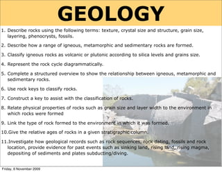
- 1. GEOLOGY 1. Describe rocks using the following terms: texture, crystal size and structure, grain size, layering, phenocrysts, fossils. 2. Describe how a range of igneous, metamorphic and sedimentary rocks are formed. 3. Classify igneous rocks as volcanic or plutonic according to silica levels and grains size. 4. Represent the rock cycle diagrammatically. 5. Complete a structured overview to show the relationship between igneous, metamorphic and sedimentary rocks. 6. Use rock keys to classify rocks. 7. Construct a key to assist with the classification of rocks. 8. Relate physical properties of rocks such as grain size and layer width to the environment in which rocks were formed 9. Link the type of rock formed to the environment in which it was formed. 10.Give the relative ages of rocks in a given stratigraphic column. 11.Investigate how geological records such as rock sequences, rock dating, fossils and rock location, provide evidence for past events such as sinking land, rising land, rising magma, depositing of sediments and plates subducting/diving. Friday, 6 November 2009
- 2. Term Definition GLOSSARY 1 geology study of the Earth’s structure and its rocks rock solid, non-living material that forms the earth’s crust minerals natural substances with a definite composition and structure elements substances made of identical atoms compounds substances made of non-identical atoms bonded together crystals solid substances showing definite geometrical shapes solidify changing from a molten to as solid state crystallise formation of crystals from molten rock or solution amorphous describes solids which do not have a crystalline structure lustre the degree of shine on the surface of a solid mass of an object compared to the mass of the same relative density volume of water used to describe an object which will affect a nearby magnetic compass needle crystalline made out of crystals transparent light passes through clearly translucent light passes through but not clearly opaque light does not pass through Friday, 6 November 2009
- 3. Term Definition GLOSSARY 2 crust the solid outer layer of rock that forms the earth’s surface mantle deep layer of molten rock underneath the crust molten in a liquid state because of high temperatures magma hot molten rock from underneath the crust igneous rock rock formed when magma solidifies plutonic igneous rock formed when magma solidifies inside the crust rock volcanic igneous rock formed when magma solidifies on or near the surface rock ash fine dust in the cloud produced by a volcanic eruption lava the molten rock that flows out of a volcano sediment rock fragments, sand and mud that settles on the sea floor weathering gradual breaking down and wearing away of exposed rock sedimentary rock rock formed when sediment hardens on the sea floor strata layers of sedimentary rock fossils remains or impressions of ancient organisms metamorphic rock rock formed under high pressure and temperature recrystallise to change the type of crystals in a solid rock cycle transformation of rock into different forms Friday, 6 November 2009
- 4. Term Definition GLOSSARY 3 protoplanet early stage in the formation of a planet radiometric dating dating rocks by the ratio of daughter to parent atoms radioactive decay atoms which can break down releasing radioactivity geological period interval of earth’s history with unique flora and fauna evolve modification of a species or formation of a new species species similar organisms capable of breeding with each other mass extinction a large number of species become extinct at the same time flora & fauna collection of plant and animal species present fossil record distribution of fossils in different rock strata global average annual temperature over the entire globe temperature global warming gradual increase in the average global temperature meteorite large rock from space which collides with the crust tectonic plates huge plates that the crust is broken up into plate boundary junction between neighboring plates convection current current in liquid caused by heated matter rising seismic activity earthquakes and tsunami mountain building crumpling up of the crust when plates collide rock strata layers of rock with different minerals and fossils Friday, 6 November 2009
- 5. THE EARTH’S STRUCTURE Friday, 6 November 2009
- 6. LAYERS - labelling & describing Demo: The Scotch egg model of the earth’s structure Imagine a Scotch egg...... 1. (breadcrumbs) 2. (sausagemeat) 3. (egg white) 4. (egg yolk) Research - The earth’s structure http://www.windows.ucar.edu/tour/link=/earth/Interior_Structure/ interior.html Diameter = ________ km. The inner core is so ___ that it causes material in the outer core and ___________to move around. _____________ ____________ thin silicate rock material ___________ mostly solid (semi-liquid/plastic) and _________ consisting of ________ _________ liquid and consisting of ________ & _________ solid and consisting of ________ & _________ Friday, 6 November 2009
- 7. HOW THICK ARE YOU?? Study the diagram carefully. It shows the earth’s layers. The depth in kilometres of the boundaries between layers is shown. 1. Put the thickness of the layers in order from thickest to thinnest. 2. A calculator may help. Thickest layer ____________ ____________ ____________ Thinnest layer ____________ Friday, 6 November 2009
- 8. HOW THICK ARE YOU?? Study the diagram carefully. It shows the earth’s layers. The depth in kilometres of the boundaries between layers is shown. 1. Put the thickness of the layers in order from thickest to thinnest. 2. A calculator may help. Thickest layer ____________ ____________ ____________ Thinnest layer ____________ Mantle thickness = 2890 - 80 = 2820 km ANSWERS Outer core thickness = 5150 - 2890 = 2260 km Friday, 6 November 2009
- 9. HOW THICK ARE YOU?? Study the diagram carefully. It shows the earth’s layers. The depth in kilometres of the boundaries between layers is shown. 1. Put the thickness of the layers in order from thickest to thinnest. 2. A calculator may help. Thickest layer ____________ ____________ ____________ Thinnest layer ____________ Note Mantle thickness = 2890 - 80 = 2820 km Some sources of information will ANSWERS Outer core thickness = 5150 - 2890 = 2260 km give the outer core as being thicker Friday, 6 November 2009
- 10. LAYERS - defining them Research - Definitions http://mediatheek.thinkquest.nl/~ll125/en/struct.htm Use the URL above to match the definition with the term with the composition with the thickness and with the average temperature Thickness Average Term Definition Composition (km) temp (oC) A. The layer above 1. Iron and Nickel. Extremely hot but (a) 2200 (i) 4500 Inner the core but below the pressure is low enough to allow it core the crust to exist as a liquid. B. The earth’s hard 2. Compounds of silicon, iron and (b) 15 (ii) 20 outer shell (which magnesium Outer floats on the softer to core part of the mantle) 870 C. The liquid layer 3. Rocks: Basalt and Granite (c) 1250 (iii) 3700 that surrounds and Mantle spins around the inner layer D. The solid, 4. Iron and Nickel. Extremely hot but (d) 2900 (iv) 2600 innermost part of under too much pressure to exist as a Crust the earth liquid. Friday, 6 November 2009
- 11. UN-MIXING THE TABLE Answers Inner core ____ ____ ____ ____ Outer core ____ ____ ____ ____ Mantle ____ ____ ____ ____ Crust ____ ____ ____ _____ Now write the correct definitions for Inner core, Outer core, Mantle and Crust in the space provided (below): Definitions The inner core is ______________________________________________________ ____________________________________________________________________ The outer core is ______________________________________________________ ____________________________________________________________________ The mantle is ________________________________________________________ ____________________________________________________________________ The crust is __________________________________________________________ ____________________________________________________________________ Friday, 6 November 2009
- 12. Reading about: THE STRUCTURE OF THE EARTH Geophysics, which studies the physics of the Earth, has led to many significant discoveries about the Earth and its make-up. Seismologic studies of the Earth have uncovered new information about the interior of the Earth that has helped to give credence to plate tectonic theory. Geophysical studies have revealed that the Earth has several distinct layers. Each of these layers has its own properties. The outermost layer of the Earth is the crust. This comprises the continents and ocean basins. The crust has a variable thickness, being 35-70 km thick in the continents and 5-10 km thick in the ocean basins. The crust is composed mainly of alumino-silicates. Silicates are based on the mineral silica, SiO2 which is a major component of sand. The next layer is the mantle, which is composed mainly of ferro-magnesium silicates. It is about 2900 km thick, and is separated into the upper and lower mantle. This is where most of the internal heat of the Earth is located. Large convective cells in the mantle circulate heat and may drive plate tectonic processes. The last layer is the core, which is separated into the liquid outer core and the solid inner core. The outer core is 2300 km thick and the inner core is 1200 km thick. The outer core is composed mainly of a nickel-iron alloy, while the inner core is almost entirely composed of iron. Earth's magnetic field is believed to be controlled by the liquid outer core. Iron and Nickel are magnetic materials. It is the motion of these materials that gives the earth its magnetic poles The Earth is separated into layers based on mechanical properties in addition to composition. The topmost layer is the lithosphere, which is comprised of the crust and solid portion of the upper mantle. The lithosphere is divided into many plates that move in relation to each other due to tectonic forces. The lithosphere essentially floats atop a semi-liquid layer known as the asthenosphere. This layer allows the solid lithosphere to move around since the asthenosphere is much weaker than the lithosphere. ---> Hwk sheet p126 “Understanding Science” Friday, 6 November 2009
- 13. MINERALS Friday, 6 November 2009
- 14. ROCKS ARE MADE OF MINERALS Granite is a rock Quartz is a mineral Questions 1. What is a mineral? 2. What is the relationship between a rock and a mineral? Friday, 6 November 2009
- 16. DESCRIBING MINERALS Hardness Colour Streak Lustre Cleavage Acid reaction Density Crystal shape and size Friday, 6 November 2009
- 17. MINERALS AND CRYSTAL STRUCTURE Crystals have flat faces and sharp edges. If the rock splits (cleaves) in certain planes then it will be made up of crystals. Iron pyrite Feldspar Quartz Most minerals are in crystal form. The shape of the crystal reflects the way that the atoms are packed. Not all minerals have their atoms packed into crystals Friday, 6 November 2009
- 18. Crystal shape and size Hexagonal Triclinic Cubic Friday, 6 November 2009
- 19. WEATHERING Friday, 6 November 2009
- 20. INTERACTIVE EXERCISE 1 Friday, 6 November 2009
- 21. What has caused these changes? Friday, 6 November 2009
- 22. What has caused these changes? WAVE ACTION Friday, 6 November 2009
- 23. What has caused these changes? WAVE ACTION STREAM ACTION Friday, 6 November 2009
- 24. What has caused these changes? WAVE ACTION STREAM ACTION WAVE ACTION Friday, 6 November 2009
- 25. What has caused these changes? EARTH MARS Friday, 6 November 2009
- 26. What has caused these changes? EARTH MARS BOTH CAUSED BY WIND Friday, 6 November 2009
- 27. What has caused these changes? Friday, 6 November 2009
- 28. What has caused these changes? ICE AND ROCKS, FALLING UNDER THE INFLUENCE OF GRAVITY Friday, 6 November 2009
- 29. What has caused these changes? Friday, 6 November 2009
- 30. What has caused these changes? ALTERNATING HEATING AND COOLING Friday, 6 November 2009
- 31. What has caused these changes? Friday, 6 November 2009
- 32. What has caused these changes? PLANT ROOTS GROWING INTO THE ROCK Friday, 6 November 2009
- 33. What has caused these changes? Friday, 6 November 2009
- 34. What has caused these changes? ACID RAIN Friday, 6 November 2009
- 35. What has caused these changes? When marble contains sulphide minerals and undergoes oxidation, the Iron II will produce rust spots, and the sulfur is converted to sulphuric acid, which can dissolve calcium. During oxidation Iron II is converted to Iron III. Friday, 6 November 2009
- 36. What has caused these changes? CHEMICAL WEATHERING (CALLED OXIDATION) When marble contains sulphide minerals and undergoes oxidation, the Iron II will produce rust spots, and the sulfur is converted to sulphuric acid, which can dissolve calcium. During oxidation Iron II is converted to Iron III. Friday, 6 November 2009
- 37. Frost Wedging (or Freeze - Thaw) There often needs to be a repetitive cycle of freezing and thawing (melting) Glaciers Weathering takes place in glaciers but not by the action of frost because the water is not freezing and thawing so regularly. Instead _____________________________________ _____________________________________ _____________________________________ This is the Fox Glacier in New Zealand. The sheet of ice is constantly moving down the mountain side, breaking off rock as it goes and carrying those pieces down the valley. Friday, 6 November 2009
- 38. WEATHERING SUMMARY Weathering is the process by which rocks are broken down. Weathering can be Mechanical or chemical. Mechanical weathering • Water can dissolve soluble rock or wear away insoluble rock through the action of waves, streams or rainfall. • Wind blows pieces of sand over rocks, wearing away softer rock • Ice and rocks falling under the influence of gravity can wear away the sides of mountains forming valleys. • Alternating heating and cooling can break down rocks over time because the rock contains different materials that expand differently. This forces the materials apart and causes the rock to be broken down into smaller pieces. • Frost action can break up rocks because when water freezes in cracks it expands, forcing the rock to split. • Plant roots can grow in rocks and as they do so they can break the rock up into smaller pieces. Chemical Weathering • Acid rain reacts with the calcium in rocks causing them to break down. • Oxidation occurs when the iron sulphide minerals in marble react with oxygen to form rust. Friday, 6 November 2009
- 39. EROSION AND ITS AGENTS Erosion is the transportation of rock, soil, and mineral particles. It is this transportation that causes material to be worn away. Erosion and weathering often occur together Sources of erosion: Gravity Water (running water, glaciers, and rain) Wind Waves EXAMPLES ________________ ________________ Friday, 6 November 2009
- 40. EROSION AND ITS AGENTS Erosion is the transportation of rock, soil, and mineral particles. It is this transportation that causes material to be worn away. Erosion and weathering often occur together Sources of erosion: Gravity Water (running water, glaciers, and rain) Wind Waves EXAMPLES ________________ ________________ Friday, 6 November 2009
- 41. WEATHERING INTERACTIVE 2 Friday, 6 November 2009
- 42. Type of weathering (Mechanical/Chemical/Biological) A B C D E 1.Copy this table into F the back of your G H book. I 2.Complete it as you J K view the slides L which follow M N O P Friday, 6 November 2009
- 43. A Friday, 6 November 2009
- 44. B Friday, 6 November 2009
- 45. C Friday, 6 November 2009
- 46. D Friday, 6 November 2009
- 47. E Friday, 6 November 2009
- 48. F Friday, 6 November 2009
- 49. G Friday, 6 November 2009
- 50. H Friday, 6 November 2009
- 51. I Friday, 6 November 2009
- 52. J Friday, 6 November 2009
- 53. K Friday, 6 November 2009
- 54. L Friday, 6 November 2009
- 55. M Friday, 6 November 2009
- 56. N Friday, 6 November 2009
- 57. O Friday, 6 November 2009
- 58. P Friday, 6 November 2009
- 59. Type of weathering - Answers A Mechanical (wind) B Mechanical (water) C Mechanical (Freeze - thaw) D Chemical weathering (acid rain) E Mechanical (Alternate heating & cooling) F Mechanical (Gravity causing Glaciers to scour out valley) G Chemical (acid rain) H Mechanical (Gravity causing Glaciers to scour out valley) I Biological weathering J Mechanical (Alternate heating & cooling) K Mechanical (Wave action) L Chemical weathering M Biological weathering N Chemical weathering (acid rain) O Biological weathering P Biological weathering Friday, 6 November 2009
- 60. Study the pictures (below) and for each picture state the source/s of erosion responsible for the observed changes. Explain how the changes occurred Farmland _______________________________________________________ _______________________________________________________ _______________________________________________________ _______________________________________________________ _______________________________________________________ _______________________________________________________ _______________________________________________________ Desert rocks _______________________________________________________ _______________________________________________________ _______________________________________________________ _______________________________________________________ Mountain slopes _______________________________________________________ _______________________________________________________ _______________________________________________________ _______________________________________________________ Stream _______________________________________________________ Friday, 6 November 2009
- 61. SORTING OUT THE ROCK CYCLE Reading: Y11 Pathfinder Choose from the labels (right) to complete the flow chart. • Melting • Deposition of sediment • Burial & compaction • Erosion & transport • Weathering of rocks at surface • Crystallisation of magma • Deformation & metamorphism Friday, 6 November 2009
- 62. SORTING OUT THE ROCK CYCLE Cut & paste the picture (below) into your book. Choose from the labels (right) to complete the flow chart. • Melting • Deposition of sediment • Burial & compaction • Erosion & transport • Weathering of rocks at surface • Crystallisation of magma • Deformation & metamorphism Friday, 6 November 2009
- 63. TYPES OF ROCK Friday, 6 November 2009
- 64. The Taupo volcanic zone includes volcanoes in the central North Island, Rotorua and the Bay of Reading about volcanoes Plenty. These volcanoes lie along the edge of the Pacific and Indo-Australian plates. Because the oceanic crust of the Pacific plate is sliding under the Indo-Australian plate, volcanic activity is seen on the continental crust of the Indo-Australian plate parallel to the plate boundary. There are different volcano types in the Taupo volcanic zone. This is because the different volcano types are created from magma from different depths along the subduction zone. The thickness of magma (how easily it flows) depends on its depth and temperature. Basalt volcanoes are formed from the eruption of thin, runny magma which comes from deep along the subduction zone where the temperature is high. This magma also has a low silica content. Taupo Volcanic Zone Friday, 6 November 2009
- 65. Silica thickens the magma and since the silica content is low the magma that forms basalt volcanoes is thin and runny. The magma that escapes from the crust to form a Basalt volcano is basic (the opposite to being acidic) and the eruptions that form the slopes of the volcano are mild. At the other extreme, if the magma comes from a shallow region of the subduction zone, where the temperature is much lower, Rhyolite volcanoes are formed. This magma which is at a lower temperature also has a high silica content and is therefore thicker and reluctant to flow easily. The magma is acidic. This results in steep sided volcanoes like Mount Tauhara and Mount Maunganui. These mountains were formed by violent eruptions. Lake Taupo was originally a rhyolite dome volcano. Pressure under the mountain rapidly dropped after a violent explosion which caused the crust to collapse. This formed a caldera. The explosion was so violent that the ash turned the sky red over Rome and China. The crater that remained filled with water to form a large lake. Andesite volcanoes are formed from magma which has a thickness, silica content and acidity which is somewhere between the basic magma of basalt volcanoes and the acidic magma of rhyolite volcanoes. Friday, 6 November 2009
- 66. Notes to copy ROCK TYPES - FORMATION OF Igneous rocks When a volcano erupts, the magma reaches the surface as lava. Lava cools to form rocks called igneous rocks. Igneous rocks contain crystals which are the result of the cooling process. There are two types of igneous rocks. Igneous volcanic (extrusive) rocks form when lava cools rapidly on or near the surface. Igneous plutonic (intrusive) rocks form when lava cools slowly under the ground. When lava cools quickly, the crystals are small (as they are in basalt). Slow cooling results in larger crystals to produce rocks like granite. Obsidian is an exception. It cools rapidly but without crystal growth. Air can also be trapped in the lava as it cools rapidly (to form rocks like pumice or scoria). acidity of Examples of rocks that Volcano type Shape Silica content lava form Rhyolite & Pumice Rhyolite (volcanic) dome Granite (plutonic) Andesite (volcanic) Andesite cone Diorite (plutonic) Basalt & scoria (volcanic) Basalt Gabbro (plutonic) Friday, 6 November 2009
- 67. Notes to copy ROCK TYPES - FORMATION OF Igneous rocks When a volcano erupts, the magma reaches the surface as lava. Lava cools to form rocks called igneous rocks. Igneous rocks contain crystals which are the result of the cooling process. There are two types of igneous rocks. Igneous volcanic (extrusive) rocks form when lava cools rapidly on or near the surface. Igneous plutonic (intrusive) rocks form when lava cools slowly under the ground. When lava cools quickly, the crystals are small (as they are in basalt). Slow cooling results in larger crystals to produce rocks like granite. Obsidian is an exception. It cools rapidly but without crystal growth. Air can also be trapped in the lava as it cools rapidly (to form rocks like pumice or scoria). acidity of Examples of rocks that Volcano type Shape Silica content lava form Rhyolite & Pumice Rhyolite acidic High (volcanic) dome Granite (plutonic) Andesite (volcanic) Andesite cone intermediate moderate Diorite (plutonic) Basalt & scoria (volcanic) Basalt basic low Gabbro (plutonic) Friday, 6 November 2009
- 68. ROCKS FROM RHYOLITE VOLCANOES Rhyolite Pumice Granite Friday, 6 November 2009
- 69. ROCKS FROM ANDESITE VOLCANOES Andesite Diorite http://images.google.com/imgres?imgurl=http://geology.com/rocks/pictures/andesite.jpg&imgrefurl=http://geology.com/rocks/igneous- rocks.shtml&usg=__sMutH3Cxn_0d- JmbYqEBZ1VRir4=&h=420&w=560&sz=46&hl=en&start=3&um=1&tbnid=7zd20fQWorrOSM:&tbnh=100&tbnw=133&prev=/images%3Fq%3Dandesite%26hl %3Den%26client%3Dsafari%26rls%3Den%26sa%3DN%26um%3D1 Friday, 6 November 2009
- 70. ROCKS FROM BASALT VOLCANOES Basalt Scoria Gabbro http://images.google.com/imgres?imgurl=http://geology.com/rocks/pictures/andesite.jpg&imgrefurl=http://geology.com/rocks/igneous- rocks.shtml&usg=__sMutH3Cxn_0d- JmbYqEBZ1VRir4=&h=420&w=560&sz=46&hl=en&start=3&um=1&tbnid=7zd20fQWorrOSM:&tbnh=100&tbnw=133&prev=/images%3Fq%3Dandesite%26hl %3Den%26client%3Dsafari%26rls%3Den%26sa%3DN%26um%3D1 Friday, 6 November 2009
- 71. Notes to copy ROCK TYPES - FORMATION OF Sedimentary rocks Over time igneous rocks are eroded and the particles (sediments) collect in rivers and oceans. This material is buried and compacted to form sedimentary rocks (such as sandstone and mudstone). Sedimentary rocks can be recognised from the existence of particles such as sand, mud and pebbles. Sedimentary rocks allow scientists to learn about the environment that existed when the layers were formed. Fossils are evidence of living things trapped in the sediments before they became rocks. Scientists can also learn about climate change from these layers. Metamorphic rocks Sedimentary rock that finds itself in deeper, hotter regions of the crust can change into metamorphic rocks. Metamorphic rocks are formed from sedimentary rocks that have been subjected to heat and pressure. This occurs in places where tectonic plates are coming together. When metamorphic rocks melt they become part of the magma. This leaves volcanoes as lava which cools to form igneous rocks and the cycle continues. Friday, 6 November 2009
- 72. SEDIMENTARY ROCK Friday, 6 November 2009
- 73. SEDIMENTARY ROCK FORMATION AND STREAM FLOW RATE • Sedimentary rocks often have thick layers. • The layers in the rock reflect the type of sediment. • A rapidly flowing stream swelled by winter rains can carry large amounts of coarse sediment with a lot of rotting leaves. • The same river in summer flows slowly and only carries a small amount of fine sediment. • The changing nature of the sediment results in variations of the rock that is formed - the amount of sediment affects the depth of the layer. • The size of the grains it contains affects the texture. • The amount of organic material can change the colour. Note that: A layer will not always be the result of the deposition of sediment in a single season. Friday, 6 November 2009
- 74. ROCK INTERACTIVE Friday, 6 November 2009
- 75. A Igneous/Metamorphic/Sedimentary ?? Friday, 6 November 2009
- 76. B Igneous/Metamorphic/Sedimentary ?? Friday, 6 November 2009
- 77. C Igneous/Metamorphic/Sedimentary ?? Schist Friday, 6 November 2009
- 78. D Igneous/Metamorphic/Sedimentary ?? Granite Friday, 6 November 2009
- 79. E Igneous/Metamorphic/Sedimentary ?? Friday, 6 November 2009
- 80. F Igneous/Metamorphic/Sedimentary ?? Friday, 6 November 2009
- 81. G Igneous/Metamorphic/Sedimentary ?? Friday, 6 November 2009
- 82. H Igneous/Metamorphic/Sedimentary ?? Friday, 6 November 2009
- 83. I Igneous/Metamorphic/Sedimentary ?? Obsidian Friday, 6 November 2009
- 84. J Igneous/Metamorphic/Sedimentary ?? Friday, 6 November 2009
- 85. K Igneous/Metamorphic/Sedimentary ?? Friday, 6 November 2009
- 86. L Igneous/Metamorphic/Sedimentary ?? Friday, 6 November 2009
- 87. M Igneous/Metamorphic/Sedimentary ?? Friday, 6 November 2009
- 88. ROCK TYPE (Igneous/Metamorphic/Sedimentary) A Metamorphic B Igneous C Metamorphic D Igneous E Sedimentary F Sedimentary G Metamorphic H Metamorphic I Igneous J Sedimentary K Igneous L Metamorphic M Sedimentary Friday, 6 November 2009
- 89. DESCRIBING ROCKS Friday, 6 November 2009
- 90. Rhyolite Pumice Granite Obsidian ROCK TYPES IN NCEA Andesite Diorite Marble Gneiss Basalt Scoria Gabbro Schist Slate Conglomerate Sandstone Mudstone Siltstone Limestone Coal Friday, 6 November 2009
- 91. Colour - includes how dark or light the rock is. This is often a result of the silica content of the rock. Silica, because of its whitish appearance lightens the colour of a rock depending on the amount of silica present. Volcanic rocks are classified by their silica content: Low silica content High silica magma Friday, 6 November 2009
- 92. Colour - includes how dark or light the rock is. This is often a result of the silica content of the rock. Silica, because of its whitish appearance lightens the colour of a rock depending on the amount of silica present. Volcanic rocks are classified by their silica content: Low silica content High silica magma Basalt Andesite Rhyolite Scoria Pumice Dark rock Light rock Basic lava Intermediate lava Acidic lava Friday, 6 November 2009
- 93. texture - the feel, appearance or consistency of a surface (a) Consistency Obsidian is smooth (b) Consistency granular poikilitic sperulitic Friday, 6 November 2009
- 94. Gravel Sized: Conglomerate Sand Sized: Sandstone Mud Sized: Mudstone Siltstone Shale (formed by mud & clay pressed together Friday, 6 November 2009
- 95. Grain shape Conglomerate - rounded grains Breccia - angular grains Grain size Gravel 2mm Sand 1/16 mm Mud/Silt 1/256 mm Grain size Rapidly flowing water transports the largest grains. Heavy particles settle to the sea floor before smaller particles. Particles are deposited in layers called strata. The oldest particles are in the lower layers. Evidence of life (fossils) can also be found in the layers. Friday, 6 November 2009
- 96. Crystal size Large crystals in rocks are formed when lava cools slowly under the ground. Small crystals in rocks are formed when lava cools rapidly above the ground. Practical CRYSTAL SIZE Aim Equipment to demonstrate the effect of rapid formation Potassium dichromate (solid) and slow formation on crystal size. Sodium chloride (solid) Method water 1. Dissolve a spatula full of sodium chloride in 0.5 microscope slides mL of water in a test tube. Repeat for potassium dichromate. 2. Put a couple of drops of each solution on two microscope slides so that you have 2 slides each with 2 drops of sodium chloride solution and 2 slides, each with 2 drops of potassium dichromate. 3. Heat 2 slides quickly (over a meths burner) and leave 2 slides overnight to allow crystals to form slowly. 4. Once formation is complete, compare the slow forming crystals with the fast forming ones. Slow formation Rapid formation Slow formation Rapid formation 1 2 3 4 Friday, 6 November 2009
- 97. USING A ROCK KEY [p148 “Understanding Science”] Conglomerate Marble Sandstone Limestone Slate Friday, 6 November 2009
- 98. PLATE TECTONICS Friday, 6 November 2009
- 99. MOVING PLATES Friday, 6 November 2009
- 100. MOVING PLATES ARE CAUSED BY CONVECTION CURRENTS Friday, 6 November 2009
- 101. TRENCHES Friday, 6 November 2009
- 102. VOLCANOES Friday, 6 November 2009
- 103. TRENCHES ARE A RESULT OF SUBDUCTION Oceanic CRUST A trench Continental CRUST Subduction zone Friday, 6 November 2009
- 104. RIDGES Friday, 6 November 2009
- 105. RIDGES ARE A RESULT OF MID-OCEANIC SPREADING Oceanic Crust Oceanic Crust Friday, 6 November 2009
- 106. CONSTRUCTION and DESCTRUCTION Friday, 6 November 2009
- 107. Notes RIDGES and TRENCHES OCCUR TOGETHER Trench Ridge Ridge Continental Plate Oceanic Plate Oceanic Plate SPREADING -->Plate construction SUBDUCTION --> Plate destruction Magma rises --> cools and expands when it contacts the ocean --> pushing of the oceanic plates apart --> Ridge formation as the magma piles up on the edge of each plate Study the diagrams carefully and use them to write a few sentences which explain how mid-ocean ridges and trenches are formed: Friday, 6 November 2009
- 108. CONTINENTS RIPPED APART --> THE CREATION OF SEA FLOOR .. a consequence of the same sea floor spreading that causes mid-ocean ridges Friday, 6 November 2009
- 109. THE BIRTH OF A SHIELD VOLCANO .. a consequence of the same sea floor spreading that causes mid-ocean ridges Friday, 6 November 2009
- 110. PLATE COLLISION WITHOUT SUBDUCTION --> faulting (crack formation) and folding (mountain formation) Friday, 6 November 2009
- 111. NEW ZEALAND’S SITUATION 2 4 3 (Southern Alps) 1 Mid-oceanic Friday, 6 November 2009
- 112. FOUR TYPES OF PLATE COLLISION 1 Mid-oceanic Magma wells up between two plates that are Ridge spreading (because of subduction occurring at the other end of each plate, pulling the plates apart). The magma piles up on the plate edges. When it makes contact with the ocean, it cools and solidifies to create ridges. 2 Subduction Continental CRUST Subduction occurs when the heavier oceanic crust Oceanic zone CRUST A trench sinks under the continental crust. Friction between the two plates and a sinking into a hotter region of the mantle causes the oceanic plate to melt. Molten magma seeps through cracks in the continental Subduction zone crust to form volcanoes and the friction causes earthquakes. The colliding plates can also cause mountain formation. New Zealand lies on subduction zones. This is caused by plates colliding directly with 3 Faulting & folding without subduction each other. There is no subduction. Neither is there sliding of the plates and causing a buckling of the crust. Mountain formation occurs (as in the Southern alps). 4 Faulting This occurs when plates simply slide past each other. This can lead to earthquakes. The Alpine fault in New Zealand is an example of such a fault. Friday, 6 November 2009
- 113. Friday, 6 November 2009
- 114. Friday, 6 November 2009
- 115. PLATE TECTONIC THEORY Friday, 6 November 2009
- 116. Notes PLATE TECTONIC THEORY • 1915 - Alfred Wegener proposed the theory of "continental drift." He suggested that the continents plowed through crust of ocean basins, which would explain why many coastlines fit together like a puzzle. He was unable, however to explain why. • Evidence for some sort of plate/continent movement: Fossils of similar species have been found on continents that are now separated by great geographic distance. • Wegener laid the groundwork for the development of modern plate tectonics. • The plate tectonic theory suggest that the plates float and move on the magma of the mantle in response to convection currents in the mantle. http://scign.jpl.nasa.gov/learn/plate2.htm Friday, 6 November 2009
- 117. Friday, 6 November 2009
- 118. Friday, 6 November 2009
- 119. http://www.tki.org.nz/r/science/science_is/activities/isact_plate_tectonics_02_e.php THE THEORY OF PLATE TECTONICS Friday, 6 November 2009
- 120. QUESTIONS 1. Describe three New Zealand geological features associated with plate movement. (i) Southern alps (folding & faulting without subduction) (ii) Alpine fault (faulting) (iii) Taupo volcanic zone (over a subduction zone) 2. Explain how volcano formation results from plate movement. Subduction (resulting from a heavier plate pushing and sinking when in contact with a lighter continental plate) causes the continental crust to weaken. Molten magma under pressure rises up through the cracks/fissures 3. Discuss the terms “plate destruction” and “plate construction”. Plate destruction occurs during subduction. The subducting plate sinks into the hotter region of the mantle and melts. Plate construction occurs where two oceanic plates are moving apart. Magma that rises to the surface and cools creates new ocean floor 4. Explain why some metamorphic rocks are found high on some New Zealand mountains. Metamorphic rocks deep in the crust can be uplifted when folding occurs (in say the Southern Alps) 5. Explain, in terms of plate movement, the location of the Taupo volcanic zone. The Taupo volcanic zone is located over a subduction zone. Subduction zones are areas where the earth’s crust is weakened as a result of a heavier oceanic plate pushing against a lighter continental plate. Friday, 6 November 2009
- 121. HIDDEN SECRETS IN ROCKS Friday, 6 November 2009
- 122. Notes EVIDENCE IN ROCKS Age of the rock In any undisturbed strata the oldest rocks are at the bottom and the youngest are at the top (the law of super imposition) Carbon dating can be used to determine the age of a rock. This technique measures the amount of Carbon 14 remaining in a fossil and because that rate at which this isotope decays is known, the age of the rock can be calculated. Unconformities can occur when there is uplifting. An uncomformity is a time break in sediment deposition. An upper layer/s in the strata become exposed and erode away to be replaced later by a new layer. The eroded layer represents a missing geological record. Life that existed in the past Fossils are evidence of the existence of life. Fossils in rocks can be imprints of a once living thing of the remains of a living thing. Fossils are found in sedimentary rocks which form part of a strata of layers. They can tell us about the creatures that inhabited the region at a particular time in the Earth’s history. Evidence relating to subduction Metamorphic rocks are formed at plate boundaries where there is subduction and can tell us how long subduction has been occurring. Friday, 6 November 2009
- 123. The direction of current in a stream The orientation of shells in sedimentary rock can show us the direction that water flows in a stream. The depth of the water Ripple marks on the rock tell us that the rock was formed in shallow water. The speed of the water flow Large grains are deposited by fast moving water and so where rocks have large grains the water would have been flowing fast. Slow flowing water carries finer grains and so rocks with fine grains are found in places where the water flows slowly. The length of a stream Long streams cause particles to become quite rounded so rocks with rounded particles indicate the location of a long stream. The salinity of the water at the time Rocks which contain cubic crystals (salt) indicate the presence of seawater at the time of formation. ESA Guide: p302: Activities 23B & 23C Friday, 6 November 2009
- 124. REGIONAL METAMORPHISM Regional metamorphism covers large areas of continental crust typically associated with mountain ranges, particularly subduction zones or the roots of previously eroded mountains. Friday, 6 November 2009