SlideShare ist ein Scribd-Unternehmen logo
1 von 46
The 2011 Missouri River Flood:
Coordinating Response and Recovery


   Scott Suhr Transportation Planner District 4
       Iowa Department of Transportation
Iowa Department
                  2011 Missouri River Flood
of Transportation

                  The Missouri River Basin
                         North Dakota


   Montana


    Wyoming     South Dakota
                                        Iowa
                  Nebraska


              Colorado


                                           Missouri   2
Iowa Department
                          2011 Missouri River Flood
        of Transportation

                 Overview of Flood Event
• Snowpack in Northern Rockies was 212% above normal.

• One year’s worth of rain fell in the Upper Missouri Basin the last
  two weeks of May.

• Water released from Gavins Point Dam June 25 exceeded
  twice the previous record and did not decrease until July 31.

• The Missouri River in Sioux City was above flood stage from
  June 5 to August 26 (82 days).

• Old oxbows / meanders filled with floodwater and groundwater.

• Longest duration flood event in U.S. history.                 3
180,000
                                                                                                 2011 Missouri River Flood Timeline - Iowa Transportation Impacts
                                                                                                                 USACE: "Peak flow of 160kcfsreduced to 150kcfs
                                                                                                                                USACE: "Flow
                                                                                                                        through August" on August 1st"
                                                                                                 USACE: "Peak flow of 150kcfs by             USACE annouces plan to step-
                                                                      160,000                              mid-June"                          down to 90kcfs by Aug 27th
                                                                                          USACE: "Peak flow of 130-
Daily Average Release from Gavins Point Dam - Cubic Feet per Second


                                                                                            150kcfs by late I-680 north interchange
                                                                                                     I-29 / June"
                                                                                                                                                                       Waters begin to recede, exposing
                                                                                                                  closes
                                                                                         USACE announces peak flow of/ I-680 north interchange
                                                                                                                    I-29
                                                                      140,000                                                                                           extensive debris and damage
                                                                                              110kcfs by late June        mitigation project
                                                                                                                      I-29 / I-680 north
                                                                                                                                                                                                       Letting for I-680 re-construction
                                                                                                                    interchange re-opens
                                                                      120,000                                                  TrapBag installation on US-30                                                    Letting for IA-175 Decatur bridge
                                                                                                                                  west of Missouri Valley                                                                     project
                                                                                                                  I-29 and IA-333 closed in                                                                                        I-680 in Council Bluffs area
                                                                                                                  Hamburg area (MP 1-10)                                                                                               (MP 1-3) re-opens
                                                                      100,000                      I-29 / Hamilton Blvd I-29 closed exit closes (exit 24)
                                                                                                                         exit Bartlett                                               I-29 / Hamilton Blvd exit re-
                                                                                                             (exit 149) mitigation on I-29 near
                                                                                                                 TrapBag                                                                   opens (exit 149)
                                                                                                                      Blencoe (MP 107-109)
                                                                                                                                                                                                       I-29 in Council Bluffs area
                                                                                                    I-680 closed in Council Bluffs area                                                                                           IA-333 near Hamburg re-
                                                                       80,000                                                                                                                             (MP 55-71) re-opens
                                                                                                                  (MP 1-3)IA-175 Decatur bridge                                                                                            opens
                                                                                                                      embankment mitigation project
                                                                                            Gavins Point exceeds all-time
                                                                                                record flow of 70kcfs
                                                                       60,000                          IA-175 shoulder protection mitigation project using 12"
                                                                                                                               I-29
                                                                                                                 project            ACC overlay (MP 103.5)                                                          I-29 near Hamburg (MP 0-
                                                                                                   I-29 Closed in Council Bluffs area                                                                                             IA-175 Decatur bridge re-
                                                                                                                                                                                                                          32) re-opens
                                                                                                               (MP 55-71)                                                                                                                  opens
                                                                                                                   IA-175 Decatur bridge closes
                                                                       40,000                        IA-2 lane closure
                                                                                                           IA-2 closed west of I-29


                                                                       20,000


                                                                           -
                                                                                27-May


                                                                                         3-Jun


                                                                                                                                                   1-Jul


                                                                                                                                                               8-Jul


                                                                                                                                                                                                                 5-Aug


                                                                                                                                                                                                                             12-Aug


                                                                                                                                                                                                                                           19-Aug


                                                                                                                                                                                                                                                    26-Aug
                                                                                                         10-Jun


                                                                                                                          17-Jun


                                                                                                                                     24-Jun


                                                                                                                                                                            15-Jul


                                                                                                                                                                                         22-Jul


                                                                                                                                                                                                    29-Jul
                                                                                                                                              2011 Release Rate         Typical Year Release Rate

                                                                                                                                                                                                                                                             4
180,000
                                                                                              2011 Missouri River Flood Timeline - Iowa Transportation Impacts
                                                                                                              USACE: "Peak flow of 160kcfsreduced to 150kcfs
                                                                                                                             USACE: "Flow
                                                                                              USACE: "Peak flow of 150kcfs byAugust" on August 1st"
                                                                                                                     through              USACE annouces plan to step-
                                                                      160,000                           mid-June"                          down to 90kcfs by Aug 27th
Daily Average Release from Gavins Point Dam - Cubic Feet per Second


                                                                                          USACE: "Peak flow of 130-
                                                                                            150kcfs by late I-680 north interchange
                                                                                                     I-29 / June"
                                                                                                                                                                       Waters begin to recede, exposing
                                                                                                                  closes
                                                                                         USACE announces peak flow of/ I-680 north interchange
                                                                                                                    I-29
                                                                      140,000                                                                                           extensive debris and damage
                                                                                              110kcfs by late June        mitigation project
                                                                                                               I-29 / I-680 north
                                                                                                                                                                                                       Letting for I-680 re-construction
                                                                                                             interchange re-opens
                                                                      120,000                                            TrapBag installation on US-30                                                           Letting for IA-175 Decatur bridge
                                                                                                                             west of Missouri Valley                                                                           project
                                                                                                           I-29 and IA-333 closed in                                                                                                I-680 in Council Bluffs area
                                                                                                           Hamburg area (MP 1-10)                                                                                                        (MP 1-3) re-opens
                                                                      100,000                     I-29 / Hamilton Blvd I-29 closed exit closes (exit 24)
                                                                                                                         exit Bartlett                                                 I-29 / Hamilton Blvd exit re-
                                                                                                              (exit 149) mitigation on I-29 near
                                                                                                                 TrapBag                                                                     opens (exit 149)
                                                                                                                      Blencoe (MP 107-109)
                                                                                                                                                                                                       I-29 in Council Bluffs area
                                                                                                    I-680 closed in Council Bluffs area                                                                                           IA-333 near Hamburg re-
                                                                       80,000                                                                                                                             (MP 55-71) re-opens
                                                                                                                  (MP 1-3)IA-175 Decatur bridge                                                                                            opens
                                                                                                                      embankment mitigation project
                                                                                            Gavins Point exceeds all-time
                                                                                                record flow of 70kcfs
                                                                       60,000                          IA-175 shoulder protection mitigation project using 12"
                                                                                                                               I-29
                                                                                                                 project            ACC overlay (MP 103.5)                                                         I-29 near Hamburg (MP 0-
                                                                                                   I-29 Closed in Council Bluffs area                                                                                            IA-175 Decatur bridge re-
                                                                                                                                                                                                                         32) re-opens
                                                                                                               (MP 55-71)                                                                                                                 opens
                                                                                                                   IA-175 Decatur bridge closes
                                                                       40,000                        IA-2 lane closure
                                                                                                           IA-2 closed west of I-29


                                                                       20,000


                                                                           -


                                                                                                                                                                                                                                             7-Nov


                                                                                                                                                                                                                                                          14-Nov
                                                                                15-Aug


                                                                                         22-Aug


                                                                                                        29-Aug


                                                                                                                     5-Sep


                                                                                                                                 12-Sep


                                                                                                                                                 19-Sep


                                                                                                                                                              26-Sep


                                                                                                                                                                               3-Oct


                                                                                                                                                                                              10-Oct


                                                                                                                                                                                                          17-Oct


                                                                                                                                                                                                                       24-Oct


                                                                                                                                                                                                                                 31-Oct
                                                                                                                                          2011 Release Rate             Typical Year Release Rate

                                                                                                                                                                                                                                                      5
Iowa Department
                         2011 Missouri River Flood
       of Transportation

Impact upon Iowa’s Primary Roads
  • I-29, I-680 and other primary routes were impacted.
     – Approximately 60 miles of roads were closed
     – I-29 closed in two segments covering almost 50 miles
     – 3 of 12 Western Iowa river crossings were closed from
       June to November

  • Emergency projects to keep sections of I-29 and US 30
    open.


                                                            6
Interstate 680 8-16-2011


                           7
I-680 near I-29 Southbound ramp


                                  8
I-680 near I-29 entrance ramp


                                9
I-29 / I-680 north of Omaha-Council Bluffs


     I-29 / I-680 Interchange looking west to Omaha   10
I-29 / I-680 north of Omaha-Council Bluffs


   I-29 / I-680 Interchange looking southwest to Omaha   11
I-29 in Southwest Iowa


  I-29 looking north at MP 15   12
I-29 in Southwest Iowa


Water and debris on roadway at MP 1   13
Rail damage in Fremont County


  Rail line looking north from Iowa 2 east of I-29   14
I-29 at Hamburg


Looking north from the Missouri border   15
Iowa Department
                         2011 Missouri River Flood
       of Transportation

Communication and Coordination
 • Initial coordination between 6 states (South
   Dakota, Minnesota, Nebraska, Iowa, Missouri and Kansas)

 • Iowa DOT hosted a daily partner conference call / webinar
   starting in June, became weekly in August and lasted into
   October.

 • Included neighboring states, Iowa state agencies, Federal
   officials and facilitated key decision-making discussions.

 • Heavy use of GIS provided partners a common operating
   picture. Used Google Earth with custom layers (inundation
   levels, LIDAR, historical imagery, etc…)
                                                            16
Iowa Department
                         2011 Missouri River Flood
       of Transportation

Communication and Coordination
 • Iowa DOT opened a flood call center for the public
    – Open from June 9 - July 12.
    – Anywhere from 2 - 8 operators at any one time, close to
      50,000 calls were received from the public.
 • A Missouri River Flood Website was hosted by Iowa DOT.
    – Contains press releases, detour maps and other
      information resources.
    – Still active, has had 2.7 million views since June 12
 • The Iowa 511 site had approximately 650,000 visits during
   peak flooding in June and July.
                                                              17
Iowa Department
                         2011 Missouri River Flood
       of Transportation

Iowa DOT Response: District Level
 • Flooding in 2 of 6 DOT Districts

 • Resources from other Districts moved to Western Iowa

 • State Disaster Proclamation issued

 • State resources used to support local flood fight

 • Missions assigned from State Emergency Operations Center

 • High degree of coordination between DOT Districts and HQ

                                                          18
Iowa Department
                          2011 Missouri River Flood
        of Transportation

Iowa DOT Response: District Level
 • Mitigation Measures employed:
    – Installation of TrapBags on shoulders and medians
    – Raised roadway elevations with HMA overlay
    – Used pumps and pipe jacking to keep water off roads

 • Coordination with local officials
    – Setting up local detour routes
    – DOT access to local resources, e.g. quarries
    – Providing information to affected residents

                                                            19
US 30 West of Missouri Valley


Installation of TrapBags on south side of US 30   20
Iowa Department
                          2011 Missouri River Flood
        of Transportation

Iowa DOT Response: HQ Level
 • Implemented Incident Command System (ICS).
 • Daily conference calls / webinars with local-state-federal
   partners, documented with Situation Reports
 • Weekly detour coordination conference calls with neighboring
   states (Kansas, Missouri, Nebraska).
 • Participated in multiple US Army Corps conference calls.
 • External Communications managed thru Public Information
   Officer (PIO) in DOT’s Office of Multimedia Services.
 • DOT’s 24/7 Operations Center posted information via the
   Iowa 511, e-mail, Twitter and other subscription services.
                                                                21
Iowa Department
                           2011 Missouri River Flood
         of Transportation


Multi-state Global Detour
June 13 – June 17


                                I-29 Detour
    I-29 in Iowa
                                150 Extra Miles
    152 Miles
                                (Kansas City – Sioux Falls)
Iowa DOT Website:
Multi-state Global Detour
  June 17 – October 8


                                 Iowa


                     Nebraska
                                 Missouri


                        Kansas
Iowa Department
                          2011 Missouri River Flood
        of Transportation

Iowa DOT Response: Local Impacts
 • A 75 mile stretch of the Missouri River had no open highway
   crossings.

 • Detours forced Interstate traffic on to local roads.

 • The decreased flow of goods and services led to economic
   displacement in communities along the river.

 • One of the three Interstate crossings in Omaha-Council Bluffs
   was closed on June 9.

 • Movement of large amounts of materials (sand and rock)
   adversely impacted local roads and residents.
                                                            24
Iowa Department
                         2011 Missouri River Flood
       of Transportation

Iowa DOT Response: Regional Impacts
 • The scope and duration of the flooding required substantial
   coordination between Iowa, Kansas, Missouri and Nebraska.

 • Coordination between the states and Federal agencies
   (FHWA, Army Corps of Engineers) aided the response.

 • Increased efforts were made between the four states to
   maintain a consistent message and coordinate detours.

 • A global detour had been in place since June to address the
   closure of I-29 in Western Iowa. Detour map hosted by Iowa
   DOT.
                                                            25
26
I-680 in Western Iowa


                                27
Receding water reveals damage
I-680 after water recedes


   I-680 westbound pavement   28
I-680 8-30-2011 after water recedes
I-29 in Southwest Iowa


                                        30
Debris on roadway after water receded
I-29 in Southwest Iowa


Drainage ditch under mainline at MP 1 - Two months after flooding began
                                                                     31
I-680 Reconstruction
        Project Timeline
•Pre-Bid Meeting             September 14th
•Bid Letting                 September 23rd
•PCI & Reilly Construction   $19,239,000
•Open to Traffic             November 2nd


                                              32
Crushing and recycling of pavement begins on I-680


                                                     33
Crews worked 24/7 during crushing and grading process


                                                        34
Truck hauling pavement to crusher


                                    35
Crews stabilizing the sub grade


                                  36
Grading contractor trimming the grade


                                        37
I-680 grade and crushing operation near Exit 1


                                                 38
View at sunrise


                  39
Paving crews paved day and night to complete the project


                                                           40
I-680 paving operation


                         41
Paving crew working at night under portable flood lights


                                                           42
View of completed I-680 prior to opening from bridge at exit 1


                                                                 43
44
Iowa Department
                           2011 Missouri River Flood
         of Transportation

Flood Recovery
 • First road closed June 4th (I-29 SB Hamilton Blvd exit in Sioux City)

 • I-29 in Council Bluffs opened September 23rd

 • I-29 in Southern Iowa opened October 8th

 • I-680 and IA-175 opened November 2nd

 • Last road opened November 11th (IA-333)

 Projects Awarded                             $ 37.1 million

 Future Projects                               $ 10.9 million

 Total                                        $ 48.0 million
                                                                     45
Iowa Department
                  2011 Missouri River Flood
of Transportation


      QUESTIONS?


                                         46

Weitere ähnliche Inhalte

Andere mochten auch

Watershed management along the Colorado River - Michael Gabaldon
Watershed management along the Colorado River - Michael GabaldonWatershed management along the Colorado River - Michael Gabaldon
Watershed management along the Colorado River - Michael GabaldonYourAlberta
 
Staying dry with rising tides – case study miami beach inc2
Staying dry with rising tides – case study miami beach   inc2Staying dry with rising tides – case study miami beach   inc2
Staying dry with rising tides – case study miami beach inc2Kerry Olsson
 
Fukushima mapping Before and after the disaster
Fukushima mapping  Before and after the disasterFukushima mapping  Before and after the disaster
Fukushima mapping Before and after the disasterikiya_OSM
 
Mitigation Symposium - Dave Ardell
Mitigation Symposium - Dave ArdellMitigation Symposium - Dave Ardell
Mitigation Symposium - Dave ArdellYourAlberta
 
Status and priorities of soil management in the United Kingdom - Helaina Black
Status and priorities of soil management in the United Kingdom - Helaina BlackStatus and priorities of soil management in the United Kingdom - Helaina Black
Status and priorities of soil management in the United Kingdom - Helaina BlackFAO
 
The brazil floods 2011 9090
The brazil floods 2011 9090The brazil floods 2011 9090
The brazil floods 2011 9090sarah9090
 
Mitigation Symposium - Scott Edelman
Mitigation Symposium - Scott EdelmanMitigation Symposium - Scott Edelman
Mitigation Symposium - Scott EdelmanYourAlberta
 
FLOODING HAZARDS, PREDICTION & MITIGATION
FLOODING HAZARDS, PREDICTION & MITIGATIONFLOODING HAZARDS, PREDICTION & MITIGATION
FLOODING HAZARDS, PREDICTION & MITIGATIONArmstrong Sompotan
 
Emergency Management Planning: Hazard Mitigation
Emergency Management Planning: Hazard MitigationEmergency Management Planning: Hazard Mitigation
Emergency Management Planning: Hazard MitigationAnuradha Mukherji
 
Mississippi Flood
Mississippi  FloodMississippi  Flood
Mississippi FloodIBGeogIST
 
Flood and drought mitigation - Matt Machielse
Flood and drought mitigation - Matt MachielseFlood and drought mitigation - Matt Machielse
Flood and drought mitigation - Matt MachielseYourAlberta
 
Flood Solutions – Soft Engineering Strategies
Flood Solutions – Soft Engineering StrategiesFlood Solutions – Soft Engineering Strategies
Flood Solutions – Soft Engineering Strategiestudorgeog
 

Andere mochten auch (16)

Watershed management along the Colorado River - Michael Gabaldon
Watershed management along the Colorado River - Michael GabaldonWatershed management along the Colorado River - Michael Gabaldon
Watershed management along the Colorado River - Michael Gabaldon
 
Staying dry with rising tides – case study miami beach inc2
Staying dry with rising tides – case study miami beach   inc2Staying dry with rising tides – case study miami beach   inc2
Staying dry with rising tides – case study miami beach inc2
 
Venice Flood
Venice FloodVenice Flood
Venice Flood
 
Fukushima mapping Before and after the disaster
Fukushima mapping  Before and after the disasterFukushima mapping  Before and after the disaster
Fukushima mapping Before and after the disaster
 
Mitigation Symposium - Dave Ardell
Mitigation Symposium - Dave ArdellMitigation Symposium - Dave Ardell
Mitigation Symposium - Dave Ardell
 
Status and priorities of soil management in the United Kingdom - Helaina Black
Status and priorities of soil management in the United Kingdom - Helaina BlackStatus and priorities of soil management in the United Kingdom - Helaina Black
Status and priorities of soil management in the United Kingdom - Helaina Black
 
The brazil floods 2011 9090
The brazil floods 2011 9090The brazil floods 2011 9090
The brazil floods 2011 9090
 
Mitigation Symposium - Scott Edelman
Mitigation Symposium - Scott EdelmanMitigation Symposium - Scott Edelman
Mitigation Symposium - Scott Edelman
 
FLOODING HAZARDS, PREDICTION & MITIGATION
FLOODING HAZARDS, PREDICTION & MITIGATIONFLOODING HAZARDS, PREDICTION & MITIGATION
FLOODING HAZARDS, PREDICTION & MITIGATION
 
Emergency Management Planning: Hazard Mitigation
Emergency Management Planning: Hazard MitigationEmergency Management Planning: Hazard Mitigation
Emergency Management Planning: Hazard Mitigation
 
Mississippi Flood
Mississippi  FloodMississippi  Flood
Mississippi Flood
 
Presentation
PresentationPresentation
Presentation
 
MOSE Project
MOSE ProjectMOSE Project
MOSE Project
 
Flood Defence Systems(97)
Flood Defence Systems(97)Flood Defence Systems(97)
Flood Defence Systems(97)
 
Flood and drought mitigation - Matt Machielse
Flood and drought mitigation - Matt MachielseFlood and drought mitigation - Matt Machielse
Flood and drought mitigation - Matt Machielse
 
Flood Solutions – Soft Engineering Strategies
Flood Solutions – Soft Engineering StrategiesFlood Solutions – Soft Engineering Strategies
Flood Solutions – Soft Engineering Strategies
 

Mehr von Mid-America Transportation Center

2023 MATC Scholars Program: Understanding Budgeting and Finance
2023 MATC Scholars Program: Understanding Budgeting and Finance2023 MATC Scholars Program: Understanding Budgeting and Finance
2023 MATC Scholars Program: Understanding Budgeting and FinanceMid-America Transportation Center
 
2023 MATC Scholars Program: Choosing a Graduate Program - Making a Short List
2023 MATC Scholars Program: Choosing a Graduate Program - Making a Short List2023 MATC Scholars Program: Choosing a Graduate Program - Making a Short List
2023 MATC Scholars Program: Choosing a Graduate Program - Making a Short ListMid-America Transportation Center
 
2023 MATC Scholars Program: Graduate School Student Experiences
2023 MATC Scholars Program: Graduate School Student Experiences2023 MATC Scholars Program: Graduate School Student Experiences
2023 MATC Scholars Program: Graduate School Student ExperiencesMid-America Transportation Center
 
2023 MATC Scholars Program: Choosing Faculty Mentors & Finding "Mentoring Com...
2023 MATC Scholars Program: Choosing Faculty Mentors & Finding "Mentoring Com...2023 MATC Scholars Program: Choosing Faculty Mentors & Finding "Mentoring Com...
2023 MATC Scholars Program: Choosing Faculty Mentors & Finding "Mentoring Com...Mid-America Transportation Center
 
2022 MATC Scholars Program: Dr. Gabriel Bruguier - Choosing a 4-year College ...
2022 MATC Scholars Program: Dr. Gabriel Bruguier - Choosing a 4-year College ...2022 MATC Scholars Program: Dr. Gabriel Bruguier - Choosing a 4-year College ...
2022 MATC Scholars Program: Dr. Gabriel Bruguier - Choosing a 4-year College ...Mid-America Transportation Center
 
MATC Webinar Series: Dr. Haitao Li - Optimizing the Configuration of Food Sup...
MATC Webinar Series: Dr. Haitao Li - Optimizing the Configuration of Food Sup...MATC Webinar Series: Dr. Haitao Li - Optimizing the Configuration of Food Sup...
MATC Webinar Series: Dr. Haitao Li - Optimizing the Configuration of Food Sup...Mid-America Transportation Center
 

Mehr von Mid-America Transportation Center (20)

2023 MATC Scholars Program: Understanding Budgeting and Finance
2023 MATC Scholars Program: Understanding Budgeting and Finance2023 MATC Scholars Program: Understanding Budgeting and Finance
2023 MATC Scholars Program: Understanding Budgeting and Finance
 
2023 MATC Scholars Program: Communication Skills
2023 MATC Scholars Program: Communication Skills2023 MATC Scholars Program: Communication Skills
2023 MATC Scholars Program: Communication Skills
 
2023 MATC Scholars Program: Why Graduate School?
2023 MATC Scholars Program: Why Graduate School?2023 MATC Scholars Program: Why Graduate School?
2023 MATC Scholars Program: Why Graduate School?
 
2023 MATC Scholars Program: Choosing a Graduate Program - Making a Short List
2023 MATC Scholars Program: Choosing a Graduate Program - Making a Short List2023 MATC Scholars Program: Choosing a Graduate Program - Making a Short List
2023 MATC Scholars Program: Choosing a Graduate Program - Making a Short List
 
2023 MATC Scholars Program: Graduate School Student Experiences
2023 MATC Scholars Program: Graduate School Student Experiences2023 MATC Scholars Program: Graduate School Student Experiences
2023 MATC Scholars Program: Graduate School Student Experiences
 
2023 MATC Scholars Program: Choosing Faculty Mentors & Finding "Mentoring Com...
2023 MATC Scholars Program: Choosing Faculty Mentors & Finding "Mentoring Com...2023 MATC Scholars Program: Choosing Faculty Mentors & Finding "Mentoring Com...
2023 MATC Scholars Program: Choosing Faculty Mentors & Finding "Mentoring Com...
 
2023 MATC Scholars Program: Program Overview
2023 MATC Scholars Program: Program Overview2023 MATC Scholars Program: Program Overview
2023 MATC Scholars Program: Program Overview
 
2015 MATC Scholars Program: Dr. Velvet Fitzpatrick
2015 MATC Scholars Program: Dr. Velvet Fitzpatrick2015 MATC Scholars Program: Dr. Velvet Fitzpatrick
2015 MATC Scholars Program: Dr. Velvet Fitzpatrick
 
2017 MATC Scholars Program: Dr. Luis Vázquez
2017 MATC Scholars Program: Dr. Luis Vázquez2017 MATC Scholars Program: Dr. Luis Vázquez
2017 MATC Scholars Program: Dr. Luis Vázquez
 
2017 MATC Scholars Program: Ms. Amy Maki
2017 MATC Scholars Program: Ms. Amy Maki2017 MATC Scholars Program: Ms. Amy Maki
2017 MATC Scholars Program: Ms. Amy Maki
 
2017 MATC Scholars Program: Dr. Edgar Blevins
2017 MATC Scholars Program: Dr. Edgar Blevins2017 MATC Scholars Program: Dr. Edgar Blevins
2017 MATC Scholars Program: Dr. Edgar Blevins
 
2017 MATC Scholars Program: Dr. Deo Chimba
2017 MATC Scholars Program: Dr. Deo Chimba2017 MATC Scholars Program: Dr. Deo Chimba
2017 MATC Scholars Program: Dr. Deo Chimba
 
2017 MATC Scholars Program: Dr. Ibibia Dabipi
2017 MATC Scholars Program: Dr. Ibibia Dabipi2017 MATC Scholars Program: Dr. Ibibia Dabipi
2017 MATC Scholars Program: Dr. Ibibia Dabipi
 
2017 MATC Scholars Program: Mr. Juhann Waller
2017 MATC Scholars Program: Mr. Juhann Waller2017 MATC Scholars Program: Mr. Juhann Waller
2017 MATC Scholars Program: Mr. Juhann Waller
 
2022 MATC Scholars Program: Dr. Gabriel Bruguier - Choosing a 4-year College ...
2022 MATC Scholars Program: Dr. Gabriel Bruguier - Choosing a 4-year College ...2022 MATC Scholars Program: Dr. Gabriel Bruguier - Choosing a 4-year College ...
2022 MATC Scholars Program: Dr. Gabriel Bruguier - Choosing a 4-year College ...
 
MATC Webinar Series: Dr. Haitao Li - Optimizing the Configuration of Food Sup...
MATC Webinar Series: Dr. Haitao Li - Optimizing the Configuration of Food Sup...MATC Webinar Series: Dr. Haitao Li - Optimizing the Configuration of Food Sup...
MATC Webinar Series: Dr. Haitao Li - Optimizing the Configuration of Food Sup...
 
2022 Intern Program - Madison Vater
2022 Intern Program - Madison Vater2022 Intern Program - Madison Vater
2022 Intern Program - Madison Vater
 
2022 Intern Program - Ryan Weyers
2022 Intern Program - Ryan Weyers2022 Intern Program - Ryan Weyers
2022 Intern Program - Ryan Weyers
 
2022 Intern Program - Abdullah Al Ajmi
2022 Intern Program - Abdullah Al Ajmi2022 Intern Program - Abdullah Al Ajmi
2022 Intern Program - Abdullah Al Ajmi
 
2022 Intern Program - Jose Aguilar
2022 Intern Program - Jose Aguilar2022 Intern Program - Jose Aguilar
2022 Intern Program - Jose Aguilar
 

Kürzlich hochgeladen

CARE OF CHILD IN INCUBATOR..........pptx
CARE OF CHILD IN INCUBATOR..........pptxCARE OF CHILD IN INCUBATOR..........pptx
CARE OF CHILD IN INCUBATOR..........pptxGaneshChakor2
 
Grant Readiness 101 TechSoup and Remy Consulting
Grant Readiness 101 TechSoup and Remy ConsultingGrant Readiness 101 TechSoup and Remy Consulting
Grant Readiness 101 TechSoup and Remy ConsultingTechSoup
 
Ecosystem Interactions Class Discussion Presentation in Blue Green Lined Styl...
Ecosystem Interactions Class Discussion Presentation in Blue Green Lined Styl...Ecosystem Interactions Class Discussion Presentation in Blue Green Lined Styl...
Ecosystem Interactions Class Discussion Presentation in Blue Green Lined Styl...fonyou31
 
Beyond the EU: DORA and NIS 2 Directive's Global Impact
Beyond the EU: DORA and NIS 2 Directive's Global ImpactBeyond the EU: DORA and NIS 2 Directive's Global Impact
Beyond the EU: DORA and NIS 2 Directive's Global ImpactPECB
 
Paris 2024 Olympic Geographies - an activity
Paris 2024 Olympic Geographies - an activityParis 2024 Olympic Geographies - an activity
Paris 2024 Olympic Geographies - an activityGeoBlogs
 
Presentation by Andreas Schleicher Tackling the School Absenteeism Crisis 30 ...
Presentation by Andreas Schleicher Tackling the School Absenteeism Crisis 30 ...Presentation by Andreas Schleicher Tackling the School Absenteeism Crisis 30 ...
Presentation by Andreas Schleicher Tackling the School Absenteeism Crisis 30 ...EduSkills OECD
 
Russian Call Girls in Andheri Airport Mumbai WhatsApp 9167673311 💞 Full Nigh...
Russian Call Girls in Andheri Airport Mumbai WhatsApp  9167673311 💞 Full Nigh...Russian Call Girls in Andheri Airport Mumbai WhatsApp  9167673311 💞 Full Nigh...
Russian Call Girls in Andheri Airport Mumbai WhatsApp 9167673311 💞 Full Nigh...Pooja Nehwal
 
Student login on Anyboli platform.helpin
Student login on Anyboli platform.helpinStudent login on Anyboli platform.helpin
Student login on Anyboli platform.helpinRaunakKeshri1
 
Sports & Fitness Value Added Course FY..
Sports & Fitness Value Added Course FY..Sports & Fitness Value Added Course FY..
Sports & Fitness Value Added Course FY..Disha Kariya
 
Accessible design: Minimum effort, maximum impact
Accessible design: Minimum effort, maximum impactAccessible design: Minimum effort, maximum impact
Accessible design: Minimum effort, maximum impactdawncurless
 
social pharmacy d-pharm 1st year by Pragati K. Mahajan
social pharmacy d-pharm 1st year by Pragati K. Mahajansocial pharmacy d-pharm 1st year by Pragati K. Mahajan
social pharmacy d-pharm 1st year by Pragati K. Mahajanpragatimahajan3
 
APM Welcome, APM North West Network Conference, Synergies Across Sectors
APM Welcome, APM North West Network Conference, Synergies Across SectorsAPM Welcome, APM North West Network Conference, Synergies Across Sectors
APM Welcome, APM North West Network Conference, Synergies Across SectorsAssociation for Project Management
 
Interactive Powerpoint_How to Master effective communication
Interactive Powerpoint_How to Master effective communicationInteractive Powerpoint_How to Master effective communication
Interactive Powerpoint_How to Master effective communicationnomboosow
 
mini mental status format.docx
mini    mental       status     format.docxmini    mental       status     format.docx
mini mental status format.docxPoojaSen20
 
1029 - Danh muc Sach Giao Khoa 10 . pdf
1029 -  Danh muc Sach Giao Khoa 10 . pdf1029 -  Danh muc Sach Giao Khoa 10 . pdf
1029 - Danh muc Sach Giao Khoa 10 . pdfQucHHunhnh
 
Kisan Call Centre - To harness potential of ICT in Agriculture by answer farm...
Kisan Call Centre - To harness potential of ICT in Agriculture by answer farm...Kisan Call Centre - To harness potential of ICT in Agriculture by answer farm...
Kisan Call Centre - To harness potential of ICT in Agriculture by answer farm...Krashi Coaching
 
Measures of Dispersion and Variability: Range, QD, AD and SD
Measures of Dispersion and Variability: Range, QD, AD and SDMeasures of Dispersion and Variability: Range, QD, AD and SD
Measures of Dispersion and Variability: Range, QD, AD and SDThiyagu K
 

Kürzlich hochgeladen (20)

CARE OF CHILD IN INCUBATOR..........pptx
CARE OF CHILD IN INCUBATOR..........pptxCARE OF CHILD IN INCUBATOR..........pptx
CARE OF CHILD IN INCUBATOR..........pptx
 
Grant Readiness 101 TechSoup and Remy Consulting
Grant Readiness 101 TechSoup and Remy ConsultingGrant Readiness 101 TechSoup and Remy Consulting
Grant Readiness 101 TechSoup and Remy Consulting
 
Ecosystem Interactions Class Discussion Presentation in Blue Green Lined Styl...
Ecosystem Interactions Class Discussion Presentation in Blue Green Lined Styl...Ecosystem Interactions Class Discussion Presentation in Blue Green Lined Styl...
Ecosystem Interactions Class Discussion Presentation in Blue Green Lined Styl...
 
Beyond the EU: DORA and NIS 2 Directive's Global Impact
Beyond the EU: DORA and NIS 2 Directive's Global ImpactBeyond the EU: DORA and NIS 2 Directive's Global Impact
Beyond the EU: DORA and NIS 2 Directive's Global Impact
 
Paris 2024 Olympic Geographies - an activity
Paris 2024 Olympic Geographies - an activityParis 2024 Olympic Geographies - an activity
Paris 2024 Olympic Geographies - an activity
 
Presentation by Andreas Schleicher Tackling the School Absenteeism Crisis 30 ...
Presentation by Andreas Schleicher Tackling the School Absenteeism Crisis 30 ...Presentation by Andreas Schleicher Tackling the School Absenteeism Crisis 30 ...
Presentation by Andreas Schleicher Tackling the School Absenteeism Crisis 30 ...
 
Advance Mobile Application Development class 07
Advance Mobile Application Development class 07Advance Mobile Application Development class 07
Advance Mobile Application Development class 07
 
Russian Call Girls in Andheri Airport Mumbai WhatsApp 9167673311 💞 Full Nigh...
Russian Call Girls in Andheri Airport Mumbai WhatsApp  9167673311 💞 Full Nigh...Russian Call Girls in Andheri Airport Mumbai WhatsApp  9167673311 💞 Full Nigh...
Russian Call Girls in Andheri Airport Mumbai WhatsApp 9167673311 💞 Full Nigh...
 
Student login on Anyboli platform.helpin
Student login on Anyboli platform.helpinStudent login on Anyboli platform.helpin
Student login on Anyboli platform.helpin
 
Sports & Fitness Value Added Course FY..
Sports & Fitness Value Added Course FY..Sports & Fitness Value Added Course FY..
Sports & Fitness Value Added Course FY..
 
Accessible design: Minimum effort, maximum impact
Accessible design: Minimum effort, maximum impactAccessible design: Minimum effort, maximum impact
Accessible design: Minimum effort, maximum impact
 
social pharmacy d-pharm 1st year by Pragati K. Mahajan
social pharmacy d-pharm 1st year by Pragati K. Mahajansocial pharmacy d-pharm 1st year by Pragati K. Mahajan
social pharmacy d-pharm 1st year by Pragati K. Mahajan
 
Mattingly "AI & Prompt Design: Structured Data, Assistants, & RAG"
Mattingly "AI & Prompt Design: Structured Data, Assistants, & RAG"Mattingly "AI & Prompt Design: Structured Data, Assistants, & RAG"
Mattingly "AI & Prompt Design: Structured Data, Assistants, & RAG"
 
APM Welcome, APM North West Network Conference, Synergies Across Sectors
APM Welcome, APM North West Network Conference, Synergies Across SectorsAPM Welcome, APM North West Network Conference, Synergies Across Sectors
APM Welcome, APM North West Network Conference, Synergies Across Sectors
 
Interactive Powerpoint_How to Master effective communication
Interactive Powerpoint_How to Master effective communicationInteractive Powerpoint_How to Master effective communication
Interactive Powerpoint_How to Master effective communication
 
mini mental status format.docx
mini    mental       status     format.docxmini    mental       status     format.docx
mini mental status format.docx
 
1029 - Danh muc Sach Giao Khoa 10 . pdf
1029 -  Danh muc Sach Giao Khoa 10 . pdf1029 -  Danh muc Sach Giao Khoa 10 . pdf
1029 - Danh muc Sach Giao Khoa 10 . pdf
 
Kisan Call Centre - To harness potential of ICT in Agriculture by answer farm...
Kisan Call Centre - To harness potential of ICT in Agriculture by answer farm...Kisan Call Centre - To harness potential of ICT in Agriculture by answer farm...
Kisan Call Centre - To harness potential of ICT in Agriculture by answer farm...
 
Measures of Dispersion and Variability: Range, QD, AD and SD
Measures of Dispersion and Variability: Range, QD, AD and SDMeasures of Dispersion and Variability: Range, QD, AD and SD
Measures of Dispersion and Variability: Range, QD, AD and SD
 
INDIA QUIZ 2024 RLAC DELHI UNIVERSITY.pptx
INDIA QUIZ 2024 RLAC DELHI UNIVERSITY.pptxINDIA QUIZ 2024 RLAC DELHI UNIVERSITY.pptx
INDIA QUIZ 2024 RLAC DELHI UNIVERSITY.pptx
 

The 2011 Missouri River Flood Coordinating Response and Recovery

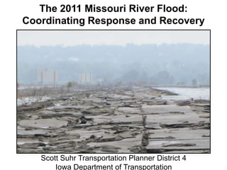
  • 1. The 2011 Missouri River Flood: Coordinating Response and Recovery Scott Suhr Transportation Planner District 4 Iowa Department of Transportation
  • 2. Iowa Department 2011 Missouri River Flood of Transportation The Missouri River Basin North Dakota Montana Wyoming South Dakota Iowa Nebraska Colorado Missouri 2
  • 3. Iowa Department 2011 Missouri River Flood of Transportation Overview of Flood Event • Snowpack in Northern Rockies was 212% above normal. • One year’s worth of rain fell in the Upper Missouri Basin the last two weeks of May. • Water released from Gavins Point Dam June 25 exceeded twice the previous record and did not decrease until July 31. • The Missouri River in Sioux City was above flood stage from June 5 to August 26 (82 days). • Old oxbows / meanders filled with floodwater and groundwater. • Longest duration flood event in U.S. history. 3
  • 4. 180,000 2011 Missouri River Flood Timeline - Iowa Transportation Impacts USACE: "Peak flow of 160kcfsreduced to 150kcfs USACE: "Flow through August" on August 1st" USACE: "Peak flow of 150kcfs by USACE annouces plan to step- 160,000 mid-June" down to 90kcfs by Aug 27th USACE: "Peak flow of 130- Daily Average Release from Gavins Point Dam - Cubic Feet per Second 150kcfs by late I-680 north interchange I-29 / June" Waters begin to recede, exposing closes USACE announces peak flow of/ I-680 north interchange I-29 140,000 extensive debris and damage 110kcfs by late June mitigation project I-29 / I-680 north Letting for I-680 re-construction interchange re-opens 120,000 TrapBag installation on US-30 Letting for IA-175 Decatur bridge west of Missouri Valley project I-29 and IA-333 closed in I-680 in Council Bluffs area Hamburg area (MP 1-10) (MP 1-3) re-opens 100,000 I-29 / Hamilton Blvd I-29 closed exit closes (exit 24) exit Bartlett I-29 / Hamilton Blvd exit re- (exit 149) mitigation on I-29 near TrapBag opens (exit 149) Blencoe (MP 107-109) I-29 in Council Bluffs area I-680 closed in Council Bluffs area IA-333 near Hamburg re- 80,000 (MP 55-71) re-opens (MP 1-3)IA-175 Decatur bridge opens embankment mitigation project Gavins Point exceeds all-time record flow of 70kcfs 60,000 IA-175 shoulder protection mitigation project using 12" I-29 project ACC overlay (MP 103.5) I-29 near Hamburg (MP 0- I-29 Closed in Council Bluffs area IA-175 Decatur bridge re- 32) re-opens (MP 55-71) opens IA-175 Decatur bridge closes 40,000 IA-2 lane closure IA-2 closed west of I-29 20,000 - 27-May 3-Jun 1-Jul 8-Jul 5-Aug 12-Aug 19-Aug 26-Aug 10-Jun 17-Jun 24-Jun 15-Jul 22-Jul 29-Jul 2011 Release Rate Typical Year Release Rate 4
  • 5. 180,000 2011 Missouri River Flood Timeline - Iowa Transportation Impacts USACE: "Peak flow of 160kcfsreduced to 150kcfs USACE: "Flow USACE: "Peak flow of 150kcfs byAugust" on August 1st" through USACE annouces plan to step- 160,000 mid-June" down to 90kcfs by Aug 27th Daily Average Release from Gavins Point Dam - Cubic Feet per Second USACE: "Peak flow of 130- 150kcfs by late I-680 north interchange I-29 / June" Waters begin to recede, exposing closes USACE announces peak flow of/ I-680 north interchange I-29 140,000 extensive debris and damage 110kcfs by late June mitigation project I-29 / I-680 north Letting for I-680 re-construction interchange re-opens 120,000 TrapBag installation on US-30 Letting for IA-175 Decatur bridge west of Missouri Valley project I-29 and IA-333 closed in I-680 in Council Bluffs area Hamburg area (MP 1-10) (MP 1-3) re-opens 100,000 I-29 / Hamilton Blvd I-29 closed exit closes (exit 24) exit Bartlett I-29 / Hamilton Blvd exit re- (exit 149) mitigation on I-29 near TrapBag opens (exit 149) Blencoe (MP 107-109) I-29 in Council Bluffs area I-680 closed in Council Bluffs area IA-333 near Hamburg re- 80,000 (MP 55-71) re-opens (MP 1-3)IA-175 Decatur bridge opens embankment mitigation project Gavins Point exceeds all-time record flow of 70kcfs 60,000 IA-175 shoulder protection mitigation project using 12" I-29 project ACC overlay (MP 103.5) I-29 near Hamburg (MP 0- I-29 Closed in Council Bluffs area IA-175 Decatur bridge re- 32) re-opens (MP 55-71) opens IA-175 Decatur bridge closes 40,000 IA-2 lane closure IA-2 closed west of I-29 20,000 - 7-Nov 14-Nov 15-Aug 22-Aug 29-Aug 5-Sep 12-Sep 19-Sep 26-Sep 3-Oct 10-Oct 17-Oct 24-Oct 31-Oct 2011 Release Rate Typical Year Release Rate 5
  • 6. Iowa Department 2011 Missouri River Flood of Transportation Impact upon Iowa’s Primary Roads • I-29, I-680 and other primary routes were impacted. – Approximately 60 miles of roads were closed – I-29 closed in two segments covering almost 50 miles – 3 of 12 Western Iowa river crossings were closed from June to November • Emergency projects to keep sections of I-29 and US 30 open. 6
  • 8. I-680 near I-29 Southbound ramp 8
  • 9. I-680 near I-29 entrance ramp 9
  • 10. I-29 / I-680 north of Omaha-Council Bluffs I-29 / I-680 Interchange looking west to Omaha 10
  • 11. I-29 / I-680 north of Omaha-Council Bluffs I-29 / I-680 Interchange looking southwest to Omaha 11
  • 12. I-29 in Southwest Iowa I-29 looking north at MP 15 12
  • 13. I-29 in Southwest Iowa Water and debris on roadway at MP 1 13
  • 14. Rail damage in Fremont County Rail line looking north from Iowa 2 east of I-29 14
  • 15. I-29 at Hamburg Looking north from the Missouri border 15
  • 16. Iowa Department 2011 Missouri River Flood of Transportation Communication and Coordination • Initial coordination between 6 states (South Dakota, Minnesota, Nebraska, Iowa, Missouri and Kansas) • Iowa DOT hosted a daily partner conference call / webinar starting in June, became weekly in August and lasted into October. • Included neighboring states, Iowa state agencies, Federal officials and facilitated key decision-making discussions. • Heavy use of GIS provided partners a common operating picture. Used Google Earth with custom layers (inundation levels, LIDAR, historical imagery, etc…) 16
  • 17. Iowa Department 2011 Missouri River Flood of Transportation Communication and Coordination • Iowa DOT opened a flood call center for the public – Open from June 9 - July 12. – Anywhere from 2 - 8 operators at any one time, close to 50,000 calls were received from the public. • A Missouri River Flood Website was hosted by Iowa DOT. – Contains press releases, detour maps and other information resources. – Still active, has had 2.7 million views since June 12 • The Iowa 511 site had approximately 650,000 visits during peak flooding in June and July. 17
  • 18. Iowa Department 2011 Missouri River Flood of Transportation Iowa DOT Response: District Level • Flooding in 2 of 6 DOT Districts • Resources from other Districts moved to Western Iowa • State Disaster Proclamation issued • State resources used to support local flood fight • Missions assigned from State Emergency Operations Center • High degree of coordination between DOT Districts and HQ 18
  • 19. Iowa Department 2011 Missouri River Flood of Transportation Iowa DOT Response: District Level • Mitigation Measures employed: – Installation of TrapBags on shoulders and medians – Raised roadway elevations with HMA overlay – Used pumps and pipe jacking to keep water off roads • Coordination with local officials – Setting up local detour routes – DOT access to local resources, e.g. quarries – Providing information to affected residents 19
  • 20. US 30 West of Missouri Valley Installation of TrapBags on south side of US 30 20
  • 21. Iowa Department 2011 Missouri River Flood of Transportation Iowa DOT Response: HQ Level • Implemented Incident Command System (ICS). • Daily conference calls / webinars with local-state-federal partners, documented with Situation Reports • Weekly detour coordination conference calls with neighboring states (Kansas, Missouri, Nebraska). • Participated in multiple US Army Corps conference calls. • External Communications managed thru Public Information Officer (PIO) in DOT’s Office of Multimedia Services. • DOT’s 24/7 Operations Center posted information via the Iowa 511, e-mail, Twitter and other subscription services. 21
  • 22. Iowa Department 2011 Missouri River Flood of Transportation Multi-state Global Detour June 13 – June 17 I-29 Detour I-29 in Iowa 150 Extra Miles 152 Miles (Kansas City – Sioux Falls)
  • 23. Iowa DOT Website: Multi-state Global Detour June 17 – October 8 Iowa Nebraska Missouri Kansas
  • 24. Iowa Department 2011 Missouri River Flood of Transportation Iowa DOT Response: Local Impacts • A 75 mile stretch of the Missouri River had no open highway crossings. • Detours forced Interstate traffic on to local roads. • The decreased flow of goods and services led to economic displacement in communities along the river. • One of the three Interstate crossings in Omaha-Council Bluffs was closed on June 9. • Movement of large amounts of materials (sand and rock) adversely impacted local roads and residents. 24
  • 25. Iowa Department 2011 Missouri River Flood of Transportation Iowa DOT Response: Regional Impacts • The scope and duration of the flooding required substantial coordination between Iowa, Kansas, Missouri and Nebraska. • Coordination between the states and Federal agencies (FHWA, Army Corps of Engineers) aided the response. • Increased efforts were made between the four states to maintain a consistent message and coordinate detours. • A global detour had been in place since June to address the closure of I-29 in Western Iowa. Detour map hosted by Iowa DOT. 25
  • 26. 26
  • 27. I-680 in Western Iowa 27 Receding water reveals damage
  • 28. I-680 after water recedes I-680 westbound pavement 28
  • 29. I-680 8-30-2011 after water recedes
  • 30. I-29 in Southwest Iowa 30 Debris on roadway after water receded
  • 31. I-29 in Southwest Iowa Drainage ditch under mainline at MP 1 - Two months after flooding began 31
  • 32. I-680 Reconstruction Project Timeline •Pre-Bid Meeting September 14th •Bid Letting September 23rd •PCI & Reilly Construction $19,239,000 •Open to Traffic November 2nd 32
  • 33. Crushing and recycling of pavement begins on I-680 33
  • 34. Crews worked 24/7 during crushing and grading process 34
  • 35. Truck hauling pavement to crusher 35
  • 36. Crews stabilizing the sub grade 36
  • 38. I-680 grade and crushing operation near Exit 1 38
  • 40. Paving crews paved day and night to complete the project 40
  • 42. Paving crew working at night under portable flood lights 42
  • 43. View of completed I-680 prior to opening from bridge at exit 1 43
  • 44. 44
  • 45. Iowa Department 2011 Missouri River Flood of Transportation Flood Recovery • First road closed June 4th (I-29 SB Hamilton Blvd exit in Sioux City) • I-29 in Council Bluffs opened September 23rd • I-29 in Southern Iowa opened October 8th • I-680 and IA-175 opened November 2nd • Last road opened November 11th (IA-333) Projects Awarded $ 37.1 million Future Projects $ 10.9 million Total $ 48.0 million 45
  • 46. Iowa Department 2011 Missouri River Flood of Transportation QUESTIONS? 46

Hinweis der Redaktion

  1. Drains nearly 1/6th of the area of the United States.Covers 500,000 square miles: Rockies to Mississippi River.2,341 miles, the longest river in the United States.735 mile navigation channel from Sioux City to St. Louis. 300 feet wide and 9 feet deep.Six major flood control reservoirs constructed 1930’s-1960’s.Gavins Point Dam (South Dakota) the last downstream dam.
  2. The2011 maximum release was 160,000 cfs from June 25 to July 31.The previous record from Gavins Point was 70,000 cfs in 1997.Release was above 70,000 cfs from May 30 – Sept 26.
  3. Started with close to 24 mitigation sites but that narrowed down to 14 and then 12, based upon where the water ended up going due to levee breaks or lack thereof.I-29 segments closed for over 100 days.
  4. Photo: W:\\Highway\\Maintenance\\Statewide Emergency Operations\\Western Iowa Flood\\Photos\\State Patrol Photos\\06-27-11 Geotagged\\6-27-11 SD to MO (04).jpg
  5. Photo: W:\\Highway\\Maintenance\\Statewide Emergency Operations\\Western Iowa Flood\\Photos\\IA 2\\07-01-11\\CIMG1397.JPG
  6. Photo: W:\\Highway\\Maintenance\\Statewide Emergency Operations\\Western Iowa Flood\\Photos\\State Patrol Photos\\07-02-11 Geotagged 3_IA2 to MO State Line\\110702_MOflooding_695.jpg
  7. Google Earth is free application, the data overlays were custom made by DOT staff, USGS and USACE.Calls utilized Adobe Connect for the video connection and standard conference calling
  8. 511 and the Flood website were two separate entities.
  9. Local cross-state coordination with local officials (Iowa-Nebraska)
  10. Photo: \\\\ntdfs\\(W)DataStor\\Highway\\Maintenance\\Statewide Emergency Operations\\Western Iowa Flood\\Mitigation Plans\\US-30\\IDOT-TrapBag-Install-OWH-01.jpg (credit to Omaha World Herald)
  11. ICS structure set up but was not fully implemented.Conference calls are on an ad-hoc basis as of October 6.
  12. This is the global detour map as it appears on the DOT’s flood website reference earlier in the presentation.This lasted for 113 days.
  13. Many locals commute across the river for work, either from Iowa to Nebraska City, Plattsmouth, Omaha or Blair or from Nebraska to Glenwood, Council Bluffs, Onawa or Sioux City.Crossing the river is a way of life for them.
  14. I-90 and I-70 saw more traffic.
  15. Right by the CB North garage (top left of the picture)DOT had two maint garages vacated from June-August.
  16. This is a recent aerial photo of the abutment area after the armoring was completed. This photo was taken Aug 11th. Note that water is still moving quickly through the area. It is expected that this area will need further mitigation as flood waters recede in order to address scour issues.Next slide: TrapBags on I-29 near MP 107Photo: W:\\Highway\\Maintenance\\Statewide Emergency Operations\\Western Iowa Flood\\Photos\\State Patrol Photos\\08-11-11 Geotagged 2_Monona county\\110811_MoRiver_190.jpg
  17. Bridges over Drainage Ditch #6.Most of the water from the levee breach north of here flowed to the east of I-29 and then went into this drainage ditch and ran south and west to get back to the Missouri River.