
Empfohlen
Empfohlen
Weitere ähnliche Inhalte
Was ist angesagt?
Was ist angesagt? (20)
Andere mochten auch
Andere mochten auch (13)
Ähnlich wie Precision Farming
Ähnlich wie Precision Farming (20)
Mehr von krishnaraoyv
Precision Farming
- 1. What is precision farming ‘Precision Farming’ is a term that appears to be misunderstood by agriculture scientists in India. This name is indiscriminately used by agricultural institutions to seek funding for their project activities. There is a need to create awareness and present information on precision farming as it is understood in developed countries. Several steps in scientific farming have been used for more than half a century in western agriculture. They include laser planning of land; chiselling; minimum tillage; complete analysis of soil samples for 12 or more essential plant nutrients; fertilizer placement in the root zone; mechanical and chemical control of weeds; integrated pest management; siphon irrigation; drip and micro-sprinkler irrigation; and ploughing back crop residues in the soil. Indian farmers with their limited knowledge and scanty practical experience on scientific methods of farming are still to adopt most of these steps in their farming operations. However, the concept of precision farming is outside the domain of these techniques. It is strictly based on the Global Positioning System (GPS), which was initially developed by U.S. defence scientists for the exclusive use of the U.S. Defence Department. The unique character of GPS is precision in time and space. In 1983, President Ronald Reagan released it to various civilian uses such as navigation, earthquake monitoring, and synchronisation of telecom networks. The initiation of GPS into farm operations is less than a decade old. Its use is fast spreading to all aspects of farm operations and beyond. Some
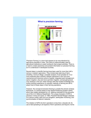
- 2. of the areas in agriculture where precision farming is taking hold with implications for the economics of farming are listed below. Since the subject is vast and fast growing, it is difficult to compile a complete list of applications in this limited presentation. 1. Soil Fertility Management a) This involves dividing a field into several small and equal divisions using the sub-inch accuracy of GPS. To do this, the tractor is fitted with a dish antenna to receive signals from satellites, which are recorded on a tractor-mounted computer. Soil samples are mechanically taken from each sub-division and this process is technically known as “Grid Sampling.” b) Samples are tested in a modern soil testing laboratory for about 17 parameters including physical and chemical characteristics of the soil and recorded. c) Using the test results of this grid samples, composite colour–grams are created through computer simulation on each of the17 parameters for the entire field (see Figure 1). d) The colour-grams are stored as stencils in the computer for various functions. One of the chief among the functions is balancing soil fertility of the field with respect to all major, secondary, and micro- nutrients. This is achieved through tractor-mounted computer guided spreader equipment capable of reading the variability of fertility from colour-grams. Fertilizers are then automatically applied at variable rates only to where they are needed as indicated by the colour-grams. In practical experience, the savings in fertilizer cost from this variable rate application alone will more than offset the cost involved in the programme. Besides, use of this method brings about greater uniformity of soil fertility in the field, leading to maximum economic yields of crops, which could not be achieved through other methods. 2. Other applications of the GPS-generated grid method The grid generated by GPS is stored in the computer and used for site- specific evaluation and monitoring of numerous functions involved in crop production to achieve peak efficiency in farm management. Some of these areas are listed below: a) Planting variable rates of seed to maximise crop yields from the specific fertility of each grid section. b) The GPS-guided grid system helps to apply variable rates of herbicides and pesticides to achieve maximum control of weeds and pests. This not only reduces the cost of chemicals used, but also improves efficiency of
- 3. pest control and protects environment. c) This enables the farmer to side dress application of fertilizers at variable rates to meet the specific requirement of each grid section, thus improving fertilizer use efficiency. d) Irrigation rates are tailored to the requirement of each grid area improving water use efficiency. f) Scouting for pest information and pest control are achieved on a site- specific basis. g) At harvest, crop yield information is recorded on a grid section basis. Solutions for differences of yield between grid sections are sought through computer analysis of all variables controlling yield of crops that are stored in the computer. Based on this, the farmer fine-tunes his or her variable rates of application of fertilizers and other impacting parameters for use in future cropping programmes. h) One other great advantage of the GPS system of farming involves the ability of the farmer to achieve greater efficiency in time control of his farm operations. This is because the GPS system enables him to operate his equipment round the clock irrespective of factors restricting visibility such as fog, darkness, or even showers. The sub-inch accuracy of GPS-based operations provides the farmer maximum efficiency with equipment operations. India is reported to spend hundreds of crores of rupees in projects called ‘Precision Farming.’ A small fraction of the current expenditure on so- called precision farming can purchase the real thing, including all hardware and software involved. The question is: when will it ever happen in India?