SlideShare a Scribd company logo
1 of 11
Associating Coordinates to Patients 1 ) Patient address goes into the system 2 ) If the address is valid then get the coordinates 3 ) Associate the coordinates to the patient's address umudugudu_id latitude longitude 0104020507 -1.9534521 30.651238 … … … address_id precision lat lon 34 1 -1.9534521 30.651238 … … …
Associating Coordinates to Patients This patient's coordinates were derived from their address This patient's coordinates were collected at their house with a gps device address_id precision lat lon 34 1 -1.9534521 30.651238 237 0 -1.9812122 30.234525
Using The Google Earth and Maps API Public internet connection Retrieve patient data in JSON Retrieve imagery from Google Web Browser Patient data
Rendering Data In The Google Earth API
Clicking on an icon renders patient data including great circle distance to the hospital Interactive Maps Using The Google Maps API
Filtering The Data ,[object Object]
Open Source Spatial Data Infrastructure PostGIS Shape Files GeoServer OpenLayers WMS Module Data Sources WMS/WFS WMS/WFS Imagery uDig (Desktop App)
Advantages of GeoServer ,[object Object],[object Object],[object Object]
uDig Displaying Data From GeoServer
OpenMRS Displaying Data From GeoServer Using OpenLayers
Sorting Through the GIS Tools Web Mapping Clients Google Earth Browser Plugin Google Maps OpenLayers Desktop Clients uDig MapWindow QuantumGIS ArcGIS Desktop Google Earth DIVA Grass GIS Server Applications GeoServer ArcGIS Server MapServer Java Libraries GeoTools JTS uDig SDK HibernateSpatial Databases PostGIS/PostgreSQL Oracle Spatial MySQL Spatial ArcSDE

More Related Content

Similar to OpenMRS and GIS

Smart Way to Track the Location in Android Operating System
Smart Way to Track the Location in Android Operating SystemSmart Way to Track the Location in Android Operating System
Smart Way to Track the Location in Android Operating SystemIOSR Journals
 
Smart soccer telegraph
Smart soccer telegraphSmart soccer telegraph
Smart soccer telegraphzinmanship
 
Application for Women Safety
Application for Women SafetyApplication for Women Safety
Application for Women Safetyiosrjce
 
Location Provider with Privacy Using Localized Server and GPS
  Location Provider with Privacy Using Localized Server and GPS   Location Provider with Privacy Using Localized Server and GPS
Location Provider with Privacy Using Localized Server and GPS Editor IJCATR
 
Introduction to Geographical Information System, GIS data models, spatial dat...
Introduction to Geographical Information System, GIS data models, spatial dat...Introduction to Geographical Information System, GIS data models, spatial dat...
Introduction to Geographical Information System, GIS data models, spatial dat...ijsrd.com
 
Optimal Facility for Location Tracking of Blood Bank and Donor
Optimal Facility for Location Tracking of Blood Bank and DonorOptimal Facility for Location Tracking of Blood Bank and Donor
Optimal Facility for Location Tracking of Blood Bank and DonorIRJET Journal
 
THE INTERACTIVE ZOOOZ GUIDE
THE INTERACTIVE ZOOOZ GUIDETHE INTERACTIVE ZOOOZ GUIDE
THE INTERACTIVE ZOOOZ GUIDEijdpsjournal
 
FME UC 2014: Hexagon Keynote
FME UC 2014: Hexagon KeynoteFME UC 2014: Hexagon Keynote
FME UC 2014: Hexagon KeynoteSafe Software
 
VRGIS and big data for smarter, healthier cities
VRGIS and big data for smarter, healthier citiesVRGIS and big data for smarter, healthier cities
VRGIS and big data for smarter, healthier citiesMaged N. Kamel Boulos
 
Cloud GIS for Crime Mapping
Cloud GIS for Crime Mapping Cloud GIS for Crime Mapping
Cloud GIS for Crime Mapping IJORCS
 
IoT + Big Data + Cloud + AI Integration Insights from Patents
IoT + Big Data  + Cloud + AI Integration Insights from PatentsIoT + Big Data  + Cloud + AI Integration Insights from Patents
IoT + Big Data + Cloud + AI Integration Insights from PatentsAlex G. Lee, Ph.D. Esq. CLP
 
Vertical fragmentation of location information to enable location privacy in ...
Vertical fragmentation of location information to enable location privacy in ...Vertical fragmentation of location information to enable location privacy in ...
Vertical fragmentation of location information to enable location privacy in ...IJASAJournal1
 
AIDSRelief Futures Group
AIDSRelief Futures Group AIDSRelief Futures Group
AIDSRelief Futures Group bobjay
 

Similar to OpenMRS and GIS (20)

Smart Way to Track the Location in Android Operating System
Smart Way to Track the Location in Android Operating SystemSmart Way to Track the Location in Android Operating System
Smart Way to Track the Location in Android Operating System
 
Smart soccer telegraph
Smart soccer telegraphSmart soccer telegraph
Smart soccer telegraph
 
Application for Women Safety
Application for Women SafetyApplication for Women Safety
Application for Women Safety
 
A017340104
A017340104A017340104
A017340104
 
Location Provider with Privacy Using Localized Server and GPS
  Location Provider with Privacy Using Localized Server and GPS   Location Provider with Privacy Using Localized Server and GPS
Location Provider with Privacy Using Localized Server and GPS
 
Find me
Find meFind me
Find me
 
Introduction to Geographical Information System, GIS data models, spatial dat...
Introduction to Geographical Information System, GIS data models, spatial dat...Introduction to Geographical Information System, GIS data models, spatial dat...
Introduction to Geographical Information System, GIS data models, spatial dat...
 
Optimal Facility for Location Tracking of Blood Bank and Donor
Optimal Facility for Location Tracking of Blood Bank and DonorOptimal Facility for Location Tracking of Blood Bank and Donor
Optimal Facility for Location Tracking of Blood Bank and Donor
 
Location based services
Location based servicesLocation based services
Location based services
 
50120140501008
5012014050100850120140501008
50120140501008
 
THE INTERACTIVE ZOOOZ GUIDE
THE INTERACTIVE ZOOOZ GUIDETHE INTERACTIVE ZOOOZ GUIDE
THE INTERACTIVE ZOOOZ GUIDE
 
FME UC 2014: Hexagon Keynote
FME UC 2014: Hexagon KeynoteFME UC 2014: Hexagon Keynote
FME UC 2014: Hexagon Keynote
 
VRGIS and big data for smarter, healthier cities
VRGIS and big data for smarter, healthier citiesVRGIS and big data for smarter, healthier cities
VRGIS and big data for smarter, healthier cities
 
Cloud GIS for Crime Mapping
Cloud GIS for Crime Mapping Cloud GIS for Crime Mapping
Cloud GIS for Crime Mapping
 
50120140501008
5012014050100850120140501008
50120140501008
 
Ai cov trac
Ai cov tracAi cov trac
Ai cov trac
 
K017547981
K017547981K017547981
K017547981
 
IoT + Big Data + Cloud + AI Integration Insights from Patents
IoT + Big Data  + Cloud + AI Integration Insights from PatentsIoT + Big Data  + Cloud + AI Integration Insights from Patents
IoT + Big Data + Cloud + AI Integration Insights from Patents
 
Vertical fragmentation of location information to enable location privacy in ...
Vertical fragmentation of location information to enable location privacy in ...Vertical fragmentation of location information to enable location privacy in ...
Vertical fragmentation of location information to enable location privacy in ...
 
AIDSRelief Futures Group
AIDSRelief Futures Group AIDSRelief Futures Group
AIDSRelief Futures Group
 

OpenMRS and GIS

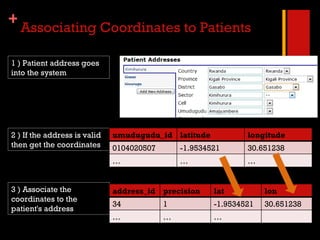
  • 1. Associating Coordinates to Patients 1 ) Patient address goes into the system 2 ) If the address is valid then get the coordinates 3 ) Associate the coordinates to the patient's address umudugudu_id latitude longitude 0104020507 -1.9534521 30.651238 … … … address_id precision lat lon 34 1 -1.9534521 30.651238 … … …
  • 2. Associating Coordinates to Patients This patient's coordinates were derived from their address This patient's coordinates were collected at their house with a gps device address_id precision lat lon 34 1 -1.9534521 30.651238 237 0 -1.9812122 30.234525
  • 3. Using The Google Earth and Maps API Public internet connection Retrieve patient data in JSON Retrieve imagery from Google Web Browser Patient data
  • 4. Rendering Data In The Google Earth API
  • 5. Clicking on an icon renders patient data including great circle distance to the hospital Interactive Maps Using The Google Maps API
  • 6.
  • 7. Open Source Spatial Data Infrastructure PostGIS Shape Files GeoServer OpenLayers WMS Module Data Sources WMS/WFS WMS/WFS Imagery uDig (Desktop App)
  • 8.
  • 9. uDig Displaying Data From GeoServer
  • 10. OpenMRS Displaying Data From GeoServer Using OpenLayers
  • 11. Sorting Through the GIS Tools Web Mapping Clients Google Earth Browser Plugin Google Maps OpenLayers Desktop Clients uDig MapWindow QuantumGIS ArcGIS Desktop Google Earth DIVA Grass GIS Server Applications GeoServer ArcGIS Server MapServer Java Libraries GeoTools JTS uDig SDK HibernateSpatial Databases PostGIS/PostgreSQL Oracle Spatial MySQL Spatial ArcSDE