
Empfohlen
Weitere ähnliche Inhalte
Was ist angesagt?
Was ist angesagt? (20)
Ähnlich wie Geography 5 photo journal
Ähnlich wie Geography 5 photo journal (17)
Kürzlich hochgeladen
Kürzlich hochgeladen (20)
Geography 5 photo journal
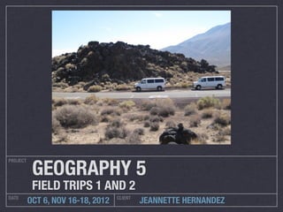
- 1. GEOGRAPHY 5 PROJECT FIELD TRIPS 1 AND 2 DATE CLIENT OCT 6, NOV 16-18, 2012 JEANNETTE HERNANDEZ
- 2. Mormon Rocks MORMON ROCKS WAS FORMED BY WIND AND WATER EROSIONS. IT IS LOCATED ON THE SAN ANDREAS RIFT ZONE. MORMON ROCKS ARE COMPOSED OF SANDSTONE , BUT OVER THE YEARS, A MIXTURE OF OTHER ROCKS WERE BLENDED INTO THE FOUNDATION.
- 3. Mormon Rocks continued... EAST WEST THE SAN ANDREAS RIFT ZONE AND STREAM BED IS LOCATED NEAR THE CAJON PASS. THE FAULT IS STRIKE-SLIP ZONE WHERE THE NORTH AMERICAN PLATE AND THE PACIFIC PLATE COME TOGETHER.
- 4. Cinder Hill Volcano This volcano is a composite and is inactive. LAVA FLOW The Lava flow is made of Basaltic Lava.
- 5. Fossil Falls stream bed The image shows the dried stream bed of Owens Lake that went through fossil falls.
- 6. Fossil Falls Fossil Falls was formed by the volcanic activity in the mountain range and meltwater from glaciers near the sierra nevada.
- 7. Fossil Falls- Metate Holes and Obsidian Flakes METATE HOLES WERE CREATED THE OBSIDIAN FLAKES FOUND BY WATER WHEN DEBRIS HIT IN FOSSIL FALLS WERE LEFT THE SAME AREA AND WOULD BY THE NATIVES AS SCRAPS CIRCULATE AGAINST THE ROCK FROM THE TOOLS THEY WOULD TO CREATE SMOOTH CIRCULAR MAKE FROM THEM, SUCH AS, HOLES. ARROW HEADS.
- 8. Fossil Falls- Petroglyph and House Rings A Petroglyph is a rock carving. The one pictured was created by native americans. The house ring was used as living space for the native americans.
- 9. Mt. Whitney Mt. Whitney is located in the Sierra Nevada Mountain range and has the highest elevation of 14,505 feet.
- 11. Alluvial Fan
- 12. Diaz Lake DIAZ LAKE WAS FORMED BY THE 1872 LONE PINE EARTHQUAKE THAT WAS THOUGHT TO BE A LEVEL 9.
- 13. Lone Pine Fault 18 MILES OF OWEN’S VALLEY DROPPED 20 FEET BECAUSE OF THE THE LONE PINE EARTHQUAKE OF 1872
- 14. Manzanar Manzanar is most widely known as the site of one of ten camps where over 110,000 Japanese Americans were incarcerated during World War II. Located at the foot of the Sierra Nevada in California's Owens Valley between the towns of Lone Pine to the south and Independence to the north, it is approximately 230 miles (370 km) northeast of Los Angeles. Manzanar (which means "apple orchard" in Spanish) was identified by the United States National Park Service as the best-preserved of the former camp sites, and was designated the Manzanar National Historic Site.
- 15. Mono Lake NEGIT ISLAND PAOHA VOLCANIC ISLAND
- 16. Former Shorelines of Mono Lake THE DIFFERENT VEGETATION REPRESENTS THE FORMER SHORELINES. THE DIFFERENCE IN COLOR SHOWS WHAT USE TO BE UNDER WATER.
- 17. Former Shorelines of Mono Lake Continued... GOAL FOR NEW SHORELINE TUFA TOWERS FORMALLY UNDER WATER
- 18. Mono Lake Tufa Towers Tufa is formed by the precipitation of carbonate minerals from ambient temperature water bodies.
- 19. Panum Crater
- 20. Convict Lake THE LAKE CREATION: DURING THE ICE AGE GLACIERS FORMED THE SIERRA NEVADAS’. OLDEST ROCK FORMATION THE SIERRA NEVADAS’ PICKED UP ROCKS AS RIVERS OF ICE MOVED DOWNHILL, MOUNDS OF RUBLE (MORAINES) WERE DEPOSITED AT THE ENDS AND ALONG THE SIDES OF GLACIERS. A RETREATING GLACIER FROM THE LAST ICE AGE LEFT BEHIND THE MORAINE THAT DAMMED CONVICT CREEK, HELPING FORM CONVICT LAKE.
- 21. Keoughs Hot Springs The hot springs were created from earthquake activity. As water flows through cracks created by earthquakes, it is heated by underground volcanic activity and pushed up.
- 22. June Lake Loop WATERFALL SILVER LAKE GRANT LAKE
- 23. Owens River
- 24. Eastern California Museum I was very interested in the old houses that the people of Manzanar use to live in. I have always been a fan of ghost towns and to me, this felt like one.
- 25. Extra Credit In Transit
- 26. SOLAR POWER PLANT SEGS III–VII at Kramer Junction
- 27. DOPPLER RADAR TOWER A Doppler radar is a specialized radar that makes use of the Doppler effect to produce velocity data about objects at a distance. It does this by beaming a microwave signal towards a desired target and listening for its reflection, then analyzing how the frequency of the returned signal has been altered by the object's motion. This variation gives direct and highly accurate measurements of the radial component of a target's velocity relative to the radar.
- 28. GARLOCK FAULT The Garlock Fault is a left-lateral strike-slip fault running approximately northeast-southwest along the north margins of the Mojave Desert of Southern California. It runs for much of its length along the southern base of the Tehachapi Mountains.
- 29. CREOSOTE BURROWEED GRASS DESERT VEGETATION JOSHUA TREE, CRESOTE, BURROWEED GRASS
- 31. OWENS DRY LAKE Owens held significant water until 1924, until much of the Owens River was diverted into the Los Angeles Aqueduct, causing it to desiccate. Today, some of the flow of the river has been restored, and the lake now contains some water.
Hinweis der Redaktion
- \n
- \n
- \n
- \n
- \n
- \n
- \n
- \n
- \n
- \n
- \n
- \n
- \n
- \n
- \n
- \n
- \n
- \n
- \n
- \n
- \n
- \n
- \n
- \n
- \n
- \n
- \n
- \n
- \n
- \n
- \n