Topography powerpoint
•Als PPT, PDF herunterladen•
32 gefällt mir•38,249 views

Topography

Empfohlen
Weitere ähnliche Inhalte
Was ist angesagt?
Was ist angesagt? (20)
Andere mochten auch
Ähnlich wie Topography powerpoint
Ähnlich wie Topography powerpoint (20)
Kürzlich hochgeladen
Kürzlich hochgeladen (20)
Topography powerpoint
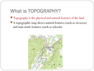
- 1. What is TOPOGRAPHY? Topography is the physical and natural features of the land A topographic map shows natural features (such as elevation) and man made features (such as schools)
- 2. Contour Lines The squiggly lines on a topographic map are called contour lines Contour lines are lines that represent a certain height or elevation All points on a contour lines are the same elevation
- 3. Contour Lines and Elevation Imagine a picture of a mountain and then imagine there were lines drawn around it every 20 feet What would the mountain with the lines look like if you stood on the side of it? What would the mountain with the lines look like if you were looking down on it from an airplane?
- 4. Contour Lines and Elevation The closer the contour lines are to each other, the steeper the slope is!
- 5. Other Topographic Terms Map scale – compares distances on the map with distances on earth. Legend – explains symbols used on the map. Index contours – contour lines that are labeled to help you find the contour interval. Relief – the difference in elevation between any 2 points A contour interval is the difference in elevation between two contour lines that are side by side. Remember that a contour interval is not the distance between the two lines – to get the distance you need to use the map scale.
- 6. Answer the Following… Circle the map scale Is there a legend? Circle at least one index contour What is the contour interval?
- 7. Mountains Mountains are represented by a series of circles This is a top down view
- 8. Depressions A depression, such as the inside of a dead volcano, is represented by Hachure lines. Hachure lines are regular contour lines with small segments sticking out from it. The first hachure line is at the same elevation as the contour line before it.
- 9. Streams Streams are found in areas of low elevation Streams are sometimes represented by a dark line Contour lines form Vs that point upstream (toward higher elevation) The Vs point in the opposite direction that the water flows
- 10. Answer the Following…. What letter represents the stream? What type of elevation is here? Which way is the water moving: to the right or to the left?
- 11. Topographic Symbols Mappers, also called cartographers use symbols to represent certain things on a topographic map For example, the color green represents an area with lots of trees or vegetation
- 12. Topographic Symbols Red is used to show a road, highway or interstate
- 13. Topographic Symbols Buildings are usually shown as little black squares
- 14. What landforms can be shown on a topographic map? Canyons – deep valleys with steep sides, often with streams flowing through River deltas – “end” of a river, where the river enters a larger body of water Mountains or hills – high elevation Valleys/depressions – low elevation Ridges – long, narrow elevation or chain of mountains
- 15. What’s happening here? Which direction has higher elevation? How do you know?
- 16. What’s happening here? Is this steeper or more gradual than the last slide? How can you tell? Which direction has higher elevation?
- 17. What’s happening here? Mountain or valley? How can you tell?
Hinweis der Redaktion
- Contour lines are spaced far apart, so we know the elevation change is gradual. The “V” shapes suggest the formation of a river, which would be flowing FROM RIGHT TO LEFT. Upstream is to the east, downstream is to the west
- Some of the lines are very close, indicating a steep incline. This is likely a canyon, formed by a river that is flowing FROM LEFT TO RIGHT.
- This is a mountain – the highest elevation is in the middle (no hachure lines to indicate this is a depression). Likely there is a river flowing westward along the Vs, which seems to be creating a canyon. The southeastern slope is steeper than the northwestern slope.