Xiaolan Zhang - Hai River Basin Presentation
•Als PPT, PDF herunterladen•
1 gefällt mir•643 views


Empfohlen
Empfohlen
Weitere ähnliche Inhalte
Was ist angesagt?
Was ist angesagt? (19)
Andere mochten auch
Andere mochten auch (11)
Ähnlich wie Xiaolan Zhang - Hai River Basin Presentation
Ähnlich wie Xiaolan Zhang - Hai River Basin Presentation (20)
Mehr von Iwl Pcu
Mehr von Iwl Pcu (20)
Xiaolan Zhang - Hai River Basin Presentation
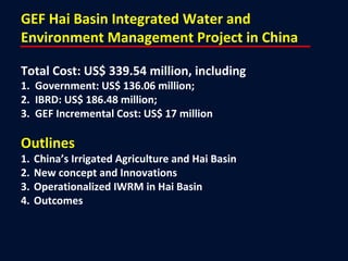
- 1. GEF Hai Basin Integrated Water and Environment Management Project in China Total Cost: US$ 339.54 million, including 1. Government: US$ 136.06 million; 2. IBRD: US$ 186.48 million; 3. GEF Incremental Cost: US$ 17 million Outlines 1. China’s Irrigated Agriculture and Hai Basin 2. New concept and Innovations 3. Operationalized IWRM in Hai Basin 4. Outcomes
- 3. 1. China’s Irrigated Agriculture & Hai Basin China’s irrigated areas: 58 million hectares increased by 8 million hectares during the past 30 years; water use 68% of total; Hai Basin’s irrigated area: 7.54 million hectares with groundwater abstraction pumped at 26 billion m3/ year, exceeds recharge by 7.2 billion m3/yr, water table drawdown by 2-3 m/yr. Surface water is overused by 2.4 billion m3/yr; Over use of water resources has resulted in serious ecological and environmental degradation and land subsidence - a big threat to 134 million people who lived in the Hai River Basin, which produces about 1/10 of grain and 1/3 of wheat in China; and The current water withdrawal permit system needs to be improved – and based on consumption rather than withdrawals
- 4. New Concept of Real Water Savings: The only water truly lost in a hydrologic system is through Evapotranspiration (ET), if genuine savings are to be made, measures should be taken to cut or reduce ET! ET-based Water Rights System: it includes three elements, namely the amount of water withdrawal, amount of water consumption (or ET) and amount of water release; Satellite Technology on ET Measurement: the technology has been used to monitor and evaluate ET variations and to reduce overuse of surface and groundwater resources at the pilot counties; IWRM at the River Basin Level: the ET target (for economic activities) and pollution-discharge target (the maximum) are determined and allocated from the river basin level to the administrative and water user level for enforcement. 2. New Concept and Innovations Note: ET ( Evapotranspiration ) is a term used to describe the sum of evaporation and plant transpiration from the Earth’s land surface to atmosphere.
- 5. Use of the Latest RS-based ET Measuring Technology Remote sensing by satellites can now provide ET readings for pixels of 30 by 30 meters with a good accuracy.
- 9. 3. Operationalized IWRM in Hai Basin We strengthened Hai Basin Commission with a joint decision making conference system to provide coordination on allocation of ET and pollution reduction targets at the Basin level and signed and implemented data sharing agreement; As agriculture is the biggest water user, the goal was to specifically control actual ET over the irrigated areas; We helped the government improve the current water withdrawal permit system to establish water rights based on ET rather than withdrawals. We established farmer water user associations one of whose jobs is to ensure that their members’ actual consumptive use of water is less than the target consumptive use allocated at the basin level; We gave farmers incentives to comply by giving them tools to increase their agricultural production or value per unit of ET (water productivity) incentives.
- 11. 4. Outcomes Indicator No. 1 – The amount of real water savings for irrigated agriculture in 16 pilot counties has reached to 266 million cubic meters, which can be used to reduce groundwater overdraft, or increase water inflow to Bohai Sea, or produce higher-value outputs; Indicator No. 2 - Reduction in pollution loading to the Bohai Sea from 16 pilot counties: Original Target Value (PAD): COD 164,000 tons/year; and NH3-N 1,900 tons/year; Actual values achieved: COD 38,615 tons /year and NH3-N 4,665 tons/year; Indicator No. 3 – Farmers’ incomes increased: In Beijing project area of farming region that is overdrawing its aquifers, the World Bank and GEF helped 360,000 farm households to save water and to leapfrog technology. Each farmer got a pre-paid card for water. Once it was used up, the pump shut down. Farmers used less water, they used it better, and their
- 12. Results of Using Satellite Technologies to Reduce ET Actual ET Before Project Actual ET After Project
Hinweis der Redaktion
- The very rapid growth of China's cities and industries had created a strong demand for water in the agricultural, urban and industrial sectors in recent years. This resulted in an imbalance between water demand and supply and as a consequence there had been a drying up of waterways and over mining of groundwater. Surface and groundwater were also heavily polluted with 68% of the total river length on the North China Plain considered polluted. As well as degraded rivers in the Hai Basin, the off-shore of Bohai Sea had become polluted to some extent and it suffered ‘red tides’ in 1989 and 1998. The important fisheries and biodiversity of the Sea were degraded and this had negative implications for the Yellow Sea and East China Sea. Integrated water and environmental management in China was also problematic because of difficulties in inter-jurisdictional and inter-administrative cooperation. For example there were considerable overlapping jurisdictions between Ministries with responsibilities for water and environmental management. Chinese Government Programs had begun to address these problems by identifying water pollution in the Bohai Sea and Hai Basin as a priority in the 9th (1995-2000) and successive National Five-Year Plans as well as preparing Action Plans and investment programs to address the pollution problems. The Government had also commenced taking measures to address water scarcity issues including by improving irrigation conservation and efficiency, water pricing and by proposing construction of the South-North Transfer (eastern and middle routes) to bring about 27 billion cubic meters of water per year from the Yangtze River system to North China including the Hai Basin. The government had also formulated related policies to improve the Bohai Sea area including the ‘Bohai Declaration’, amendment of the Marine Environmental Protection Law, and the introduction of the ‘Blue Sea Action program’. The overall objective is to catalyze an integrated approach to water resource management and pollution control in the Hai Basin in order to improve the Bohai Sea environment Global Significance of the Project: The Bohai Sea is located in the North West of the Yellow Sea and had provided important fisheries for China, Japan and North and South Korea. More than 40 rivers discharged from the North China Plains into the Bohai Sea including from the Hai Basin. The Sea also had a diverse marine life and has in the past been important for fisheries recruitment for the East China Seas and North West Pacific. The deteriorating environment and water scarcity could also lead to adverse impact on water quality of Bohai Sea, which could be of global significance and concern. The project supported the objectives of the International Convention on Biodiversity and falls under the GEF International Waters Focal Area. It had direct relevance for the Global Program for the Protection of the Marine Environment from Land Based Activities. The project also complemented other GEF initiatives including the ‘Yellow Sea Large Marine Ecosystem Project’ and the ‘Partnerships in Environmental Management for the Seas of East Asia’. The Project would support the development of top-down and bottom-up mechanisms for integrated water and environment management in the Hai Basin, based to the extent possible on existing institutional mechanisms. The Project would also promote development of new coordination approaches at all levels that would adopt practical and pragmatic methods to overcome current institutional barriers to integrated water and environment management. The Project included four components: Component 1: Integrated Water and Environment Management – IWEM Component 2: Knowledge Management - KM Subcomponent 2A - Knowledge Management: This subcomponent would provide a service function for all users and clients within the Project and would provide hardware and software tools to help Project participants to address their specific issues; and Subcomponent 2B - Establishment of Remote Sensing Evapotranspiration Management System: This subcomponent would support improvements in the conservation of water resources and the water environment, in order to achieve a rational water balance and its sustainable management, based on a focus on ET management.
- There are altogether 29 Key Performance Indicators including 12 outcome/impact indicators and 17 output indicators . These indicators are summarized below as same as they are presented in the main text of PAD: Decreased water pollution in pilot counties (tons of reduction); Reduced Groundwater overdraft in pilot counties (rate of water table lowering reduced); Reduced pollution loading to the Bohai Sea from pilot counties and coastal counties; Inter-agencies committees established in Integrated Water and Environmental Management (IWEM) in counties and in demonstration counties; Formulated Integrated Water and Environmental Management Plans (IWEMPs) for 10 selected counties in the Hai Basin and for Tianjin Municipality; Produced eight Strategic Studies at central and Hai Basin levels and integrated findings into IWEMPs; Carried out four Demonstration Projects and integrated findings into IWEMPs; Formulated Strategic Action Plans (SAP) for the Zhangweinan (ZWN) sub-basin and Hai Basin; Established Integrated Water Resource- Water Quality Information Management System; Established a functional Evapotranspiration (ET) Management system for the Hai Basin; Implementation of improved small city wastewater management in Tianjin coastal counties; Construction of two small city wastewater treatment plants in Tianjin; and Disposal of contaminated sediment from Dagu canal