SlideShare ist ein Scribd-Unternehmen logo
1 von 11
Watershed area  A watershed can be defined as the area of land that drains to a particular point along a stream. Each stream has its own watershed. Topography is the key element affecting this area of land. The boundary of a watershed is defined by the highest elevations surrounding the stream. A drop of water falling outside of the boundary will drain to another watershed.  By Ariani andayani G051060061 Watershed and Stream Network Auto-Delineation with ArcGIS Source: www.dcnr.state.pa.us/brc/rivers/riversconservation/registry/Sewickley_Creek/ watershed def.pdf   Objective:  - Delineate a watershed area. - Find the streams of the rivers using 3D Analyst
[object Object],[object Object],Prosedure & Result
3). Clip data appropiate by available hydrology data boundary with  3D analyst tools  Raster Math  Minus 4). Remove Error Sink in the DEM a. Convert the DEM to integer with  Spatial analyst    Raster Calculator b. Remove an error sink with Spatial analyst tool --> Hydrology --> Fill Step 3 Step 4a Step 4b
5). Generate Flow Direction Spatial analyst tool    Hydrology    Flow Direction Step 5
6). Generate Flow Accumulation   Spatial analyst tool    Hydrology    Flow Accumulation Step 6
Step 7 7). Generating Channel, based on Flow Accumulation Spatial analyst    Raster Calculator  ‘ Flow Accumulation >= 500’
Step 8 8). Generating Stream Link Spatial analyst tool    Hydrology    Stream Link Use stream chanel and Flow Direction as an input
9). Generating Watershed Spatial analyst tool    Hydrology   Watershed Use Flow Direction and Stream Link as an input Step 9
Manual delineation is time consuming Auto delineation is possible by 3D analyst with ArcGIS Error stream network delineation   Flat topography More reasonable    Rough topography Discussion
3D view of study area
Watershen and Stream link

Weitere ähnliche Inhalte

Was ist angesagt?

Watershed Delineation in ArcGIS
Watershed Delineation in ArcGISWatershed Delineation in ArcGIS
Watershed Delineation in ArcGISArthur Green
 
3D Analyst - Watershed Lorelindu
3D Analyst - Watershed Lorelindu3D Analyst - Watershed Lorelindu
3D Analyst - Watershed LorelinduHartanto Sanjaya
 
3D Analyst Watershed Lombok
3D Analyst Watershed  Lombok3D Analyst Watershed  Lombok
3D Analyst Watershed LombokHartanto Sanjaya
 
1 catchment delineation.ppt
1 catchment delineation.ppt1 catchment delineation.ppt
1 catchment delineation.pptmarwan B
 
Use of the German Weather Services KLAM Model to Investigate the Cold Air Dra...
Use of the German Weather Services KLAM Model to Investigate the Cold Air Dra...Use of the German Weather Services KLAM Model to Investigate the Cold Air Dra...
Use of the German Weather Services KLAM Model to Investigate the Cold Air Dra...IES / IAQM
 
Determining the k in k-means with MapReduce
Determining the k in k-means with MapReduceDetermining the k in k-means with MapReduce
Determining the k in k-means with MapReduceThibault Debatty
 
Watershed development and drainage assessments
Watershed development and drainage assessmentsWatershed development and drainage assessments
Watershed development and drainage assessmentsAndrew Harrison
 
Map to Image Georeferencing using ERDAS software
 Map  to Image Georeferencing using ERDAS software Map  to Image Georeferencing using ERDAS software
Map to Image Georeferencing using ERDAS softwareSwetha A
 
Watershed Delineation of Kolhapur District Maharashtra, India
Watershed Delineation of Kolhapur District Maharashtra, IndiaWatershed Delineation of Kolhapur District Maharashtra, India
Watershed Delineation of Kolhapur District Maharashtra, Indiaabhijeetbmore
 
Point Clouds: What's New
Point Clouds: What's NewPoint Clouds: What's New
Point Clouds: What's NewSafe Software
 
Exploring Raster with FME
Exploring Raster with FMEExploring Raster with FME
Exploring Raster with FMESafe Software
 
Spatial interpolation techniques
Spatial interpolation techniquesSpatial interpolation techniques
Spatial interpolation techniquesManisha Shrivastava
 
2017 ASPRS-RMR Big Data Track: Using ArcGIS and a Digital Elevation Model to ...
2017 ASPRS-RMR Big Data Track: Using ArcGIS and a Digital Elevation Model to ...2017 ASPRS-RMR Big Data Track: Using ArcGIS and a Digital Elevation Model to ...
2017 ASPRS-RMR Big Data Track: Using ArcGIS and a Digital Elevation Model to ...GIS in the Rockies
 
How Rough Is Your Runway?
How Rough Is Your Runway? How Rough Is Your Runway?
How Rough Is Your Runway? Safe Software
 
Interpolation
InterpolationInterpolation
Interpolationseidmmd
 

Was ist angesagt? (20)

Watershed Delineation in ArcGIS
Watershed Delineation in ArcGISWatershed Delineation in ArcGIS
Watershed Delineation in ArcGIS
 
3D Analyst - Cut and Fill
3D Analyst - Cut and Fill3D Analyst - Cut and Fill
3D Analyst - Cut and Fill
 
3D Analyst - Watershed Lorelindu
3D Analyst - Watershed Lorelindu3D Analyst - Watershed Lorelindu
3D Analyst - Watershed Lorelindu
 
3D Analyst Watershed Lombok
3D Analyst Watershed  Lombok3D Analyst Watershed  Lombok
3D Analyst Watershed Lombok
 
1 catchment delineation.ppt
1 catchment delineation.ppt1 catchment delineation.ppt
1 catchment delineation.ppt
 
Use of the German Weather Services KLAM Model to Investigate the Cold Air Dra...
Use of the German Weather Services KLAM Model to Investigate the Cold Air Dra...Use of the German Weather Services KLAM Model to Investigate the Cold Air Dra...
Use of the German Weather Services KLAM Model to Investigate the Cold Air Dra...
 
Determining the k in k-means with MapReduce
Determining the k in k-means with MapReduceDetermining the k in k-means with MapReduce
Determining the k in k-means with MapReduce
 
Watershed development and drainage assessments
Watershed development and drainage assessmentsWatershed development and drainage assessments
Watershed development and drainage assessments
 
Qswat
Qswat Qswat
Qswat
 
The Analogues R-Package - Ramirez-Villegas
The Analogues R-Package - Ramirez-VillegasThe Analogues R-Package - Ramirez-Villegas
The Analogues R-Package - Ramirez-Villegas
 
Map to Image Georeferencing using ERDAS software
 Map  to Image Georeferencing using ERDAS software Map  to Image Georeferencing using ERDAS software
Map to Image Georeferencing using ERDAS software
 
Watershed Delineation of Kolhapur District Maharashtra, India
Watershed Delineation of Kolhapur District Maharashtra, IndiaWatershed Delineation of Kolhapur District Maharashtra, India
Watershed Delineation of Kolhapur District Maharashtra, India
 
Point Clouds: What's New
Point Clouds: What's NewPoint Clouds: What's New
Point Clouds: What's New
 
Exploring Raster with FME
Exploring Raster with FMEExploring Raster with FME
Exploring Raster with FME
 
Spatial interpolation techniques
Spatial interpolation techniquesSpatial interpolation techniques
Spatial interpolation techniques
 
Hypsometric areas
Hypsometric areasHypsometric areas
Hypsometric areas
 
2017 ASPRS-RMR Big Data Track: Using ArcGIS and a Digital Elevation Model to ...
2017 ASPRS-RMR Big Data Track: Using ArcGIS and a Digital Elevation Model to ...2017 ASPRS-RMR Big Data Track: Using ArcGIS and a Digital Elevation Model to ...
2017 ASPRS-RMR Big Data Track: Using ArcGIS and a Digital Elevation Model to ...
 
How Rough Is Your Runway?
How Rough Is Your Runway? How Rough Is Your Runway?
How Rough Is Your Runway?
 
R kmethod
R kmethodR kmethod
R kmethod
 
Interpolation
InterpolationInterpolation
Interpolation
 

Ähnlich wie 3D Analyst - Watershed and Stream Network

2016 conservation track: evaluating lidar derived synthetic streams as a ...
2016 conservation track: evaluating   lidar derived   synthetic streams as a ...2016 conservation track: evaluating   lidar derived   synthetic streams as a ...
2016 conservation track: evaluating lidar derived synthetic streams as a ...GIS in the Rockies
 
Application Of HEC-GeoHMS As A Tool Of Hydrologic Modeling In The Field Of Wa...
Application Of HEC-GeoHMS As A Tool Of Hydrologic Modeling In The Field Of Wa...Application Of HEC-GeoHMS As A Tool Of Hydrologic Modeling In The Field Of Wa...
Application Of HEC-GeoHMS As A Tool Of Hydrologic Modeling In The Field Of Wa...Whitney Anderson
 
Exercise advanced gis_and_hydrology
Exercise advanced gis_and_hydrologyExercise advanced gis_and_hydrology
Exercise advanced gis_and_hydrologyBUGINGO Annanie
 
23 - NRSC - Remote Satellite Imgae - Hydrology and Water Management-Sep-17
23 - NRSC - Remote Satellite Imgae - Hydrology and Water Management-Sep-1723 - NRSC - Remote Satellite Imgae - Hydrology and Water Management-Sep-17
23 - NRSC - Remote Satellite Imgae - Hydrology and Water Management-Sep-17indiawrm
 
Rodriguez_et_al_SWOT_IGARSS2011.ppt
Rodriguez_et_al_SWOT_IGARSS2011.pptRodriguez_et_al_SWOT_IGARSS2011.ppt
Rodriguez_et_al_SWOT_IGARSS2011.pptgrssieee
 
Rodriguez_et_al_SWOT_IGARSS2011.ppt
Rodriguez_et_al_SWOT_IGARSS2011.pptRodriguez_et_al_SWOT_IGARSS2011.ppt
Rodriguez_et_al_SWOT_IGARSS2011.pptgrssieee
 
M.S. Capstone Seminar
M.S. Capstone SeminarM.S. Capstone Seminar
M.S. Capstone Seminarshirabay
 
JGrass: the Horton machine (FOSS4G2008)
JGrass: the Horton machine (FOSS4G2008)JGrass: the Horton machine (FOSS4G2008)
JGrass: the Horton machine (FOSS4G2008)Andrea Antonello
 
Geomorphology Maps
Geomorphology MapsGeomorphology Maps
Geomorphology Mapshaythemdinar
 
Petroleum lunch seminar 30.10.2014
Petroleum lunch seminar 30.10.2014Petroleum lunch seminar 30.10.2014
Petroleum lunch seminar 30.10.2014Geodata AS
 
Use of Satellite Data for Feasibility Study And Preliminary Design Project Re...
Use of Satellite Data for Feasibility Study And Preliminary Design Project Re...Use of Satellite Data for Feasibility Study And Preliminary Design Project Re...
Use of Satellite Data for Feasibility Study And Preliminary Design Project Re...IJERDJOURNAL
 
Application of remote sensing and gis for groundwater
Application of remote sensing and gis for groundwaterApplication of remote sensing and gis for groundwater
Application of remote sensing and gis for groundwaterRamodh Jayawardena
 
CaoTupinThursday20110722.ppt
CaoTupinThursday20110722.pptCaoTupinThursday20110722.ppt
CaoTupinThursday20110722.pptgrssieee
 
Hydrologic Monitoring Network Questionnaire
Hydrologic Monitoring Network QuestionnaireHydrologic Monitoring Network Questionnaire
Hydrologic Monitoring Network Questionnaireindiawrm
 
Some rudimentary steps to use ArcGis 3D Analyst
Some rudimentary steps to use ArcGis 3D AnalystSome rudimentary steps to use ArcGis 3D Analyst
Some rudimentary steps to use ArcGis 3D AnalystSaliur Silvee
 

Ähnlich wie 3D Analyst - Watershed and Stream Network (20)

WATERSHED ANALYSIS .pptx
WATERSHED ANALYSIS .pptxWATERSHED ANALYSIS .pptx
WATERSHED ANALYSIS .pptx
 
2016 conservation track: evaluating lidar derived synthetic streams as a ...
2016 conservation track: evaluating   lidar derived   synthetic streams as a ...2016 conservation track: evaluating   lidar derived   synthetic streams as a ...
2016 conservation track: evaluating lidar derived synthetic streams as a ...
 
Potentiel3.0 hydro
Potentiel3.0 hydroPotentiel3.0 hydro
Potentiel3.0 hydro
 
Application Of HEC-GeoHMS As A Tool Of Hydrologic Modeling In The Field Of Wa...
Application Of HEC-GeoHMS As A Tool Of Hydrologic Modeling In The Field Of Wa...Application Of HEC-GeoHMS As A Tool Of Hydrologic Modeling In The Field Of Wa...
Application Of HEC-GeoHMS As A Tool Of Hydrologic Modeling In The Field Of Wa...
 
CE573_Poster2
CE573_Poster2CE573_Poster2
CE573_Poster2
 
Exercise advanced gis_and_hydrology
Exercise advanced gis_and_hydrologyExercise advanced gis_and_hydrology
Exercise advanced gis_and_hydrology
 
23 - NRSC - Remote Satellite Imgae - Hydrology and Water Management-Sep-17
23 - NRSC - Remote Satellite Imgae - Hydrology and Water Management-Sep-1723 - NRSC - Remote Satellite Imgae - Hydrology and Water Management-Sep-17
23 - NRSC - Remote Satellite Imgae - Hydrology and Water Management-Sep-17
 
Rodriguez_et_al_SWOT_IGARSS2011.ppt
Rodriguez_et_al_SWOT_IGARSS2011.pptRodriguez_et_al_SWOT_IGARSS2011.ppt
Rodriguez_et_al_SWOT_IGARSS2011.ppt
 
Rodriguez_et_al_SWOT_IGARSS2011.ppt
Rodriguez_et_al_SWOT_IGARSS2011.pptRodriguez_et_al_SWOT_IGARSS2011.ppt
Rodriguez_et_al_SWOT_IGARSS2011.ppt
 
M.S. Capstone Seminar
M.S. Capstone SeminarM.S. Capstone Seminar
M.S. Capstone Seminar
 
JGrass: the Horton machine (FOSS4G2008)
JGrass: the Horton machine (FOSS4G2008)JGrass: the Horton machine (FOSS4G2008)
JGrass: the Horton machine (FOSS4G2008)
 
Geomorphology Maps
Geomorphology MapsGeomorphology Maps
Geomorphology Maps
 
Petroleum lunch seminar 30.10.2014
Petroleum lunch seminar 30.10.2014Petroleum lunch seminar 30.10.2014
Petroleum lunch seminar 30.10.2014
 
Use of Satellite Data for Feasibility Study And Preliminary Design Project Re...
Use of Satellite Data for Feasibility Study And Preliminary Design Project Re...Use of Satellite Data for Feasibility Study And Preliminary Design Project Re...
Use of Satellite Data for Feasibility Study And Preliminary Design Project Re...
 
SmartGeo - G. Satta
SmartGeo - G. SattaSmartGeo - G. Satta
SmartGeo - G. Satta
 
Final Ppt.pdf
Final Ppt.pdfFinal Ppt.pdf
Final Ppt.pdf
 
Application of remote sensing and gis for groundwater
Application of remote sensing and gis for groundwaterApplication of remote sensing and gis for groundwater
Application of remote sensing and gis for groundwater
 
CaoTupinThursday20110722.ppt
CaoTupinThursday20110722.pptCaoTupinThursday20110722.ppt
CaoTupinThursday20110722.ppt
 
Hydrologic Monitoring Network Questionnaire
Hydrologic Monitoring Network QuestionnaireHydrologic Monitoring Network Questionnaire
Hydrologic Monitoring Network Questionnaire
 
Some rudimentary steps to use ArcGis 3D Analyst
Some rudimentary steps to use ArcGis 3D AnalystSome rudimentary steps to use ArcGis 3D Analyst
Some rudimentary steps to use ArcGis 3D Analyst
 

Mehr von Hartanto Sanjaya

Kerjasama Kajian Hyperspectral OPT PTISDA - BBPOPT
Kerjasama Kajian Hyperspectral OPT PTISDA - BBPOPTKerjasama Kajian Hyperspectral OPT PTISDA - BBPOPT
Kerjasama Kajian Hyperspectral OPT PTISDA - BBPOPTHartanto Sanjaya
 
Pemanfaatan Hyperspectral dalam Bidang Pertanian
Pemanfaatan Hyperspectral dalam Bidang PertanianPemanfaatan Hyperspectral dalam Bidang Pertanian
Pemanfaatan Hyperspectral dalam Bidang PertanianHartanto Sanjaya
 
Ekspose Kegiatan "Hyperspectral-OPT"
Ekspose Kegiatan "Hyperspectral-OPT"Ekspose Kegiatan "Hyperspectral-OPT"
Ekspose Kegiatan "Hyperspectral-OPT"Hartanto Sanjaya
 
Sijampang - Sistem Informasi Hujan dan Genangan Berbasis Keruangan
Sijampang - Sistem Informasi Hujan dan Genangan Berbasis KeruanganSijampang - Sistem Informasi Hujan dan Genangan Berbasis Keruangan
Sijampang - Sistem Informasi Hujan dan Genangan Berbasis KeruanganHartanto Sanjaya
 
Citra Anaglyph untuk Tampakan 3-Dimensi
Citra Anaglyph untuk Tampakan 3-DimensiCitra Anaglyph untuk Tampakan 3-Dimensi
Citra Anaglyph untuk Tampakan 3-DimensiHartanto Sanjaya
 
Iwan Ridwansyah Morphometricand Watershedof Lake Diatas
Iwan Ridwansyah Morphometricand Watershedof Lake DiatasIwan Ridwansyah Morphometricand Watershedof Lake Diatas
Iwan Ridwansyah Morphometricand Watershedof Lake DiatasHartanto Sanjaya
 
Ahmad Mauliddin Vol Of Water In Bili Bili
Ahmad Mauliddin Vol Of Water In Bili BiliAhmad Mauliddin Vol Of Water In Bili Bili
Ahmad Mauliddin Vol Of Water In Bili BiliHartanto Sanjaya
 
Jimmy A Kadar Vol Of Water Cirata
Jimmy A Kadar Vol Of Water CirataJimmy A Kadar Vol Of Water Cirata
Jimmy A Kadar Vol Of Water CirataHartanto Sanjaya
 
3D Analyst - Lake Lorelindu by GRASS
3D Analyst - Lake Lorelindu by GRASS3D Analyst - Lake Lorelindu by GRASS
3D Analyst - Lake Lorelindu by GRASSHartanto Sanjaya
 

Mehr von Hartanto Sanjaya (15)

Kerjasama Kajian Hyperspectral OPT PTISDA - BBPOPT
Kerjasama Kajian Hyperspectral OPT PTISDA - BBPOPTKerjasama Kajian Hyperspectral OPT PTISDA - BBPOPT
Kerjasama Kajian Hyperspectral OPT PTISDA - BBPOPT
 
Pemanfaatan Hyperspectral dalam Bidang Pertanian
Pemanfaatan Hyperspectral dalam Bidang PertanianPemanfaatan Hyperspectral dalam Bidang Pertanian
Pemanfaatan Hyperspectral dalam Bidang Pertanian
 
Ekspose Kegiatan "Hyperspectral-OPT"
Ekspose Kegiatan "Hyperspectral-OPT"Ekspose Kegiatan "Hyperspectral-OPT"
Ekspose Kegiatan "Hyperspectral-OPT"
 
Sijampang - Sistem Informasi Hujan dan Genangan Berbasis Keruangan
Sijampang - Sistem Informasi Hujan dan Genangan Berbasis KeruanganSijampang - Sistem Informasi Hujan dan Genangan Berbasis Keruangan
Sijampang - Sistem Informasi Hujan dan Genangan Berbasis Keruangan
 
Citra Anaglyph untuk Tampakan 3-Dimensi
Citra Anaglyph untuk Tampakan 3-DimensiCitra Anaglyph untuk Tampakan 3-Dimensi
Citra Anaglyph untuk Tampakan 3-Dimensi
 
Sijampang
SijampangSijampang
Sijampang
 
Greenwich
GreenwichGreenwich
Greenwich
 
Iwan Ridwansyah Morphometricand Watershedof Lake Diatas
Iwan Ridwansyah Morphometricand Watershedof Lake DiatasIwan Ridwansyah Morphometricand Watershedof Lake Diatas
Iwan Ridwansyah Morphometricand Watershedof Lake Diatas
 
Ahmad Mauliddin Vol Of Water In Bili Bili
Ahmad Mauliddin Vol Of Water In Bili BiliAhmad Mauliddin Vol Of Water In Bili Bili
Ahmad Mauliddin Vol Of Water In Bili Bili
 
Jimmy A Kadar Vol Of Water Cirata
Jimmy A Kadar Vol Of Water CirataJimmy A Kadar Vol Of Water Cirata
Jimmy A Kadar Vol Of Water Cirata
 
3D Analyst Lab 1
3D Analyst Lab 13D Analyst Lab 1
3D Analyst Lab 1
 
3 D Analyst
3 D Analyst3 D Analyst
3 D Analyst
 
3D Analyst - Lake Lorelindu by GRASS
3D Analyst - Lake Lorelindu by GRASS3D Analyst - Lake Lorelindu by GRASS
3D Analyst - Lake Lorelindu by GRASS
 
3D Analyst - Lab
3D Analyst - Lab3D Analyst - Lab
3D Analyst - Lab
 
3D Analyst
3D Analyst3D Analyst
3D Analyst
 

Kürzlich hochgeladen

8447779800, Low rate Call girls in Saket Delhi NCR
8447779800, Low rate Call girls in Saket Delhi NCR8447779800, Low rate Call girls in Saket Delhi NCR
8447779800, Low rate Call girls in Saket Delhi NCRashishs7044
 
8447779800, Low rate Call girls in Kotla Mubarakpur Delhi NCR
8447779800, Low rate Call girls in Kotla Mubarakpur Delhi NCR8447779800, Low rate Call girls in Kotla Mubarakpur Delhi NCR
8447779800, Low rate Call girls in Kotla Mubarakpur Delhi NCRashishs7044
 
Ten Organizational Design Models to align structure and operations to busines...
Ten Organizational Design Models to align structure and operations to busines...Ten Organizational Design Models to align structure and operations to busines...
Ten Organizational Design Models to align structure and operations to busines...Seta Wicaksana
 
Call Girls Contact Number Andheri 9920874524
Call Girls Contact Number Andheri 9920874524Call Girls Contact Number Andheri 9920874524
Call Girls Contact Number Andheri 9920874524najka9823
 
Entrepreneurship lessons in Philippines
Entrepreneurship lessons in  PhilippinesEntrepreneurship lessons in  Philippines
Entrepreneurship lessons in PhilippinesDavidSamuel525586
 
Guide Complete Set of Residential Architectural Drawings PDF
Guide Complete Set of Residential Architectural Drawings PDFGuide Complete Set of Residential Architectural Drawings PDF
Guide Complete Set of Residential Architectural Drawings PDFChandresh Chudasama
 
MAHA Global and IPR: Do Actions Speak Louder Than Words?
MAHA Global and IPR: Do Actions Speak Louder Than Words?MAHA Global and IPR: Do Actions Speak Louder Than Words?
MAHA Global and IPR: Do Actions Speak Louder Than Words?Olivia Kresic
 
8447779800, Low rate Call girls in Dwarka mor Delhi NCR
8447779800, Low rate Call girls in Dwarka mor Delhi NCR8447779800, Low rate Call girls in Dwarka mor Delhi NCR
8447779800, Low rate Call girls in Dwarka mor Delhi NCRashishs7044
 
Kenya Coconut Production Presentation by Dr. Lalith Perera
Kenya Coconut Production Presentation by Dr. Lalith PereraKenya Coconut Production Presentation by Dr. Lalith Perera
Kenya Coconut Production Presentation by Dr. Lalith Pereraictsugar
 
Annual General Meeting Presentation Slides
Annual General Meeting Presentation SlidesAnnual General Meeting Presentation Slides
Annual General Meeting Presentation SlidesKeppelCorporation
 
8447779800, Low rate Call girls in New Ashok Nagar Delhi NCR
8447779800, Low rate Call girls in New Ashok Nagar Delhi NCR8447779800, Low rate Call girls in New Ashok Nagar Delhi NCR
8447779800, Low rate Call girls in New Ashok Nagar Delhi NCRashishs7044
 
Market Sizes Sample Report - 2024 Edition
Market Sizes Sample Report - 2024 EditionMarket Sizes Sample Report - 2024 Edition
Market Sizes Sample Report - 2024 EditionMintel Group
 
The-Ethical-issues-ghhhhhhhhjof-Byjus.pptx
The-Ethical-issues-ghhhhhhhhjof-Byjus.pptxThe-Ethical-issues-ghhhhhhhhjof-Byjus.pptx
The-Ethical-issues-ghhhhhhhhjof-Byjus.pptxmbikashkanyari
 
8447779800, Low rate Call girls in Uttam Nagar Delhi NCR
8447779800, Low rate Call girls in Uttam Nagar Delhi NCR8447779800, Low rate Call girls in Uttam Nagar Delhi NCR
8447779800, Low rate Call girls in Uttam Nagar Delhi NCRashishs7044
 
PB Project 1: Exploring Your Personal Brand
PB Project 1: Exploring Your Personal BrandPB Project 1: Exploring Your Personal Brand
PB Project 1: Exploring Your Personal BrandSharisaBethune
 
Fordham -How effective decision-making is within the IT department - Analysis...
Fordham -How effective decision-making is within the IT department - Analysis...Fordham -How effective decision-making is within the IT department - Analysis...
Fordham -How effective decision-making is within the IT department - Analysis...Peter Ward
 
FULL ENJOY Call girls in Paharganj Delhi | 8377087607
FULL ENJOY Call girls in Paharganj Delhi | 8377087607FULL ENJOY Call girls in Paharganj Delhi | 8377087607
FULL ENJOY Call girls in Paharganj Delhi | 8377087607dollysharma2066
 
NewBase 19 April 2024 Energy News issue - 1717 by Khaled Al Awadi.pdf
NewBase  19 April  2024  Energy News issue - 1717 by Khaled Al Awadi.pdfNewBase  19 April  2024  Energy News issue - 1717 by Khaled Al Awadi.pdf
NewBase 19 April 2024 Energy News issue - 1717 by Khaled Al Awadi.pdfKhaled Al Awadi
 

Kürzlich hochgeladen (20)

8447779800, Low rate Call girls in Saket Delhi NCR
8447779800, Low rate Call girls in Saket Delhi NCR8447779800, Low rate Call girls in Saket Delhi NCR
8447779800, Low rate Call girls in Saket Delhi NCR
 
Call Us ➥9319373153▻Call Girls In North Goa
Call Us ➥9319373153▻Call Girls In North GoaCall Us ➥9319373153▻Call Girls In North Goa
Call Us ➥9319373153▻Call Girls In North Goa
 
8447779800, Low rate Call girls in Kotla Mubarakpur Delhi NCR
8447779800, Low rate Call girls in Kotla Mubarakpur Delhi NCR8447779800, Low rate Call girls in Kotla Mubarakpur Delhi NCR
8447779800, Low rate Call girls in Kotla Mubarakpur Delhi NCR
 
Ten Organizational Design Models to align structure and operations to busines...
Ten Organizational Design Models to align structure and operations to busines...Ten Organizational Design Models to align structure and operations to busines...
Ten Organizational Design Models to align structure and operations to busines...
 
Call Girls Contact Number Andheri 9920874524
Call Girls Contact Number Andheri 9920874524Call Girls Contact Number Andheri 9920874524
Call Girls Contact Number Andheri 9920874524
 
Entrepreneurship lessons in Philippines
Entrepreneurship lessons in  PhilippinesEntrepreneurship lessons in  Philippines
Entrepreneurship lessons in Philippines
 
Guide Complete Set of Residential Architectural Drawings PDF
Guide Complete Set of Residential Architectural Drawings PDFGuide Complete Set of Residential Architectural Drawings PDF
Guide Complete Set of Residential Architectural Drawings PDF
 
MAHA Global and IPR: Do Actions Speak Louder Than Words?
MAHA Global and IPR: Do Actions Speak Louder Than Words?MAHA Global and IPR: Do Actions Speak Louder Than Words?
MAHA Global and IPR: Do Actions Speak Louder Than Words?
 
8447779800, Low rate Call girls in Dwarka mor Delhi NCR
8447779800, Low rate Call girls in Dwarka mor Delhi NCR8447779800, Low rate Call girls in Dwarka mor Delhi NCR
8447779800, Low rate Call girls in Dwarka mor Delhi NCR
 
Kenya Coconut Production Presentation by Dr. Lalith Perera
Kenya Coconut Production Presentation by Dr. Lalith PereraKenya Coconut Production Presentation by Dr. Lalith Perera
Kenya Coconut Production Presentation by Dr. Lalith Perera
 
Annual General Meeting Presentation Slides
Annual General Meeting Presentation SlidesAnnual General Meeting Presentation Slides
Annual General Meeting Presentation Slides
 
8447779800, Low rate Call girls in New Ashok Nagar Delhi NCR
8447779800, Low rate Call girls in New Ashok Nagar Delhi NCR8447779800, Low rate Call girls in New Ashok Nagar Delhi NCR
8447779800, Low rate Call girls in New Ashok Nagar Delhi NCR
 
Corporate Profile 47Billion Information Technology
Corporate Profile 47Billion Information TechnologyCorporate Profile 47Billion Information Technology
Corporate Profile 47Billion Information Technology
 
Market Sizes Sample Report - 2024 Edition
Market Sizes Sample Report - 2024 EditionMarket Sizes Sample Report - 2024 Edition
Market Sizes Sample Report - 2024 Edition
 
The-Ethical-issues-ghhhhhhhhjof-Byjus.pptx
The-Ethical-issues-ghhhhhhhhjof-Byjus.pptxThe-Ethical-issues-ghhhhhhhhjof-Byjus.pptx
The-Ethical-issues-ghhhhhhhhjof-Byjus.pptx
 
8447779800, Low rate Call girls in Uttam Nagar Delhi NCR
8447779800, Low rate Call girls in Uttam Nagar Delhi NCR8447779800, Low rate Call girls in Uttam Nagar Delhi NCR
8447779800, Low rate Call girls in Uttam Nagar Delhi NCR
 
PB Project 1: Exploring Your Personal Brand
PB Project 1: Exploring Your Personal BrandPB Project 1: Exploring Your Personal Brand
PB Project 1: Exploring Your Personal Brand
 
Fordham -How effective decision-making is within the IT department - Analysis...
Fordham -How effective decision-making is within the IT department - Analysis...Fordham -How effective decision-making is within the IT department - Analysis...
Fordham -How effective decision-making is within the IT department - Analysis...
 
FULL ENJOY Call girls in Paharganj Delhi | 8377087607
FULL ENJOY Call girls in Paharganj Delhi | 8377087607FULL ENJOY Call girls in Paharganj Delhi | 8377087607
FULL ENJOY Call girls in Paharganj Delhi | 8377087607
 
NewBase 19 April 2024 Energy News issue - 1717 by Khaled Al Awadi.pdf
NewBase  19 April  2024  Energy News issue - 1717 by Khaled Al Awadi.pdfNewBase  19 April  2024  Energy News issue - 1717 by Khaled Al Awadi.pdf
NewBase 19 April 2024 Energy News issue - 1717 by Khaled Al Awadi.pdf
 

3D Analyst - Watershed and Stream Network

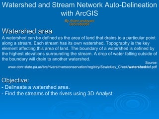
  • 1. Watershed area A watershed can be defined as the area of land that drains to a particular point along a stream. Each stream has its own watershed. Topography is the key element affecting this area of land. The boundary of a watershed is defined by the highest elevations surrounding the stream. A drop of water falling outside of the boundary will drain to another watershed. By Ariani andayani G051060061 Watershed and Stream Network Auto-Delineation with ArcGIS Source: www.dcnr.state.pa.us/brc/rivers/riversconservation/registry/Sewickley_Creek/ watershed def.pdf Objective: - Delineate a watershed area. - Find the streams of the rivers using 3D Analyst
  • 2.
  • 3. 3). Clip data appropiate by available hydrology data boundary with 3D analyst tools  Raster Math  Minus 4). Remove Error Sink in the DEM a. Convert the DEM to integer with Spatial analyst  Raster Calculator b. Remove an error sink with Spatial analyst tool --> Hydrology --> Fill Step 3 Step 4a Step 4b
  • 4. 5). Generate Flow Direction Spatial analyst tool  Hydrology  Flow Direction Step 5
  • 5. 6). Generate Flow Accumulation Spatial analyst tool  Hydrology  Flow Accumulation Step 6
  • 6. Step 7 7). Generating Channel, based on Flow Accumulation Spatial analyst  Raster Calculator ‘ Flow Accumulation >= 500’
  • 7. Step 8 8). Generating Stream Link Spatial analyst tool  Hydrology  Stream Link Use stream chanel and Flow Direction as an input
  • 8. 9). Generating Watershed Spatial analyst tool  Hydrology  Watershed Use Flow Direction and Stream Link as an input Step 9
  • 9. Manual delineation is time consuming Auto delineation is possible by 3D analyst with ArcGIS Error stream network delineation  Flat topography More reasonable  Rough topography Discussion
  • 10. 3D view of study area