![Presentation Overview ,[object Object]](data:image/gif;base64,R0lGODlhAQABAIAAAAAAAP///yH5BAEAAAAALAAAAAABAAEAAAIBRAA7)
Empfohlen
Empfohlen
Weitere ähnliche Inhalte
Was ist angesagt?
Was ist angesagt? (20)
Ähnlich wie IGARSS__RTC.pptx
Ähnlich wie IGARSS__RTC.pptx (20)
Mehr von grssieee
Mehr von grssieee (20)
Kürzlich hochgeladen
Kürzlich hochgeladen (20)
IGARSS__RTC.pptx
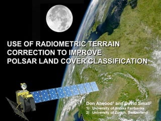
- 1. USE OF RADIOMETRIC TERRAIN CORRECTION TO IMPROVE POLSAR LAND COVER CLASSIFICATION Don Atwood1 and David Small2 University of Alaska Fairbanks University of Zurich, Switzerland
- 3. Focus on species differentiation in boreal environment
- 4. Introduce reference data for land cover classification
- 5. Introduce method of Radiometric Terrain Correction (RTC)
- 6. Terrain-flattened Gamma Naught Backscatter
- 7. Perform RTC on polarimetric parameters to address topography
- 8. Demonstrate synergy of PolSARpro and MapReady Tools
- 9. Compare results for RTC-corrected and non-corrected classification
- 11. wetlands
- 13. black spruce forests (north facing)
- 14. birch forests (south facing)
- 17. 21.5 degree look angle
- 19. Leaf-on
- 20. Coverage includes Fairbanks and regional roadsPauli Image
- 21. Problem of Topography Span (Trace of T3 Matrix) Wishart Segmentation
- 24. Backscatter Reference Areas For an Ellipsoidal Earth Relationships between cross sections for ellipsoidal surfaces
- 27. Terrain-flattening Solution: Use simulated image to Normalize β0 X Ref.: Small, D., Flattening Gamma: Radiometric Terrain Correction for SAR Imagery, IEEE Transactions on Geoscience and Remote Sensing, 13p (in press).
- 28. Terrain Correction in Coastal BC Vancouver GTC (Sept 2008) Integrated contributing area ENVISAT ASAR WSM data courtesy ESA(based on SRTM3)
- 29. Terrain Correction in Coastal BC GTC (Sept 2008) Integrated contributing area ENVISAT ASAR WSM data courtesy ESA(based on SRTM3)
- 30. Coastal BC: GTC ASAR WSM GTC
- 31. Coastal BC: RTC ASAR WSM RTC
- 32. Coastal BC: NORLIM ASAR WSM NORLIM
- 33. Coherency Matrix Scattering Matrix : “Double Bounce” : “Single Bounce” : “Volume Scattering”
- 35. Radiometric Terrain Correctionof Coherency Matrix Span: No Normalization Span: Terrain-model Normalization
- 36. Radiometric Terrain Correctionof Coherency Matrix Pauli: No Normalization Pauli: Terrain-model Normalization
- 37. Integration of PolSARpro and MapReady Ingest PALSAR data Terrain-correct Perform WishartExport to GIS Generate T3 with MapReadydecomposition Cluster-busting Radiometric correction using area Lee Sigma Speckle Filter POA compensation
- 38. Radiometric Terrain Correctionof Coherency Matrix Wishart - No Normalization Wishart - Radiometric Correction
- 39. Radiometric Terrain Correctionof Coherency Matrix USGS Reference Wishart– Radiometric Correction
- 40. Classification Results No Normalization USGS Reference RTC
- 41. Classification Results Urban areas missed / Identified as Open Water
- 42. Classification Results Inability to distinguish Mixed Forests and Shrub / Scrub
- 43. Accuracy Assessment No Normalization
- 44. Accuracy Assessment With RTC
- 47. Data fusion provides greatest hope for accurate classification results
- 48. Radiometric variability caused by topography dominates PolSAR classification
- 49. Area-based RTC offers effective way to “flatten” SAR radiometry
- 50. RTC of Coherency Matrix shown to improve classification accuracy:
- 51. Impact most pronounced for Deciduous Forests
- 52. Although not complete, RTC approach is simple and effective
- 53. Different scattering mechanisms (SB, DB, Volume) have different sensitivities to topography. RTC does not address this