SlideShare ist ein Scribd-Unternehmen logo
1 von 11
Downloaden Sie, um offline zu lesen
One of the greatest engineering achievements of ancient times is a water
tunnel, 1,036 meters (4,000 feet) long, excavated through a mountain on the
Greek island of Samos in the sixth century B.C.

..,... ........
I

..- -,.

"

'.

.-

II,,·
110,·

I

,...

.-

I"h" ...

..
d, .. "'I., t

. , . S
SA 1'10
S 'IOS

--- .. -.

-----::- ~...~
...

1oj"
1..-,,

.-"
"II
hb

.~

E N G I N E E R I N G

&

S C I E N C E

N O

. 1



-. f

I"
...·'''r .. " if) >- ~(.
I

no .. ,'

,~

..- '" - ......
~

'.-

'~1
.
"
,

.....,;.~

~..-:

"

~11=.

.

:Iftll l,
lB.

-.

'illl

,.

.J.• .1::..~.

~,

' ''~-:=

£i

,...
....

,~ ­
.

-'-'

'.c...·oJ .. '"

30

......

-

f

..

--."-- 

..... ,.

Ii'I" ...... ',h".. 'f" '" "-I:.

-

,e......

,
•

--

- .'q.- -

--

",.

I

.
,
>.:,

-
The Tunnel of Samos
by Tom M. Apostol

Facing page: This 1884
map by Ernst Fabricius
shows the tunnel running
obliquely through the hill
marked as Kastro, now
Mount Castro. The small
fishing village of Tigáni has
since been renamed
Pythagorion. The cutaway
view through Mount Castro
at the top of this page
comes from a detailed
1995 survey by the
German Archaeological
Institute in Athens.
Below: Hero of
Alexandria’s theoretical
method for working out
the line of a tunnel dug
simultaneously from both
ends.

One of the greatest engineering achievements of
ancient times is a water tunnel, 1,036 meters
(4,000 feet) long, excavated through a mountain
on the Greek island of Samos in the sixth century
B.C. It was dug through solid limestone by two
separate teams advancing in a straight line from
both ends, using only picks, hammers, and chisels.
This was a prodigious feat of manual labor. The
intellectual feat of determining the direction of
tunneling was equally impressive. How did they
do this? No one knows for sure, because no written
records exist. When the tunnel was dug, the
Greeks had no magnetic compass, no surveying
instruments, no topographic maps, nor even much
written mathematics at their disposal. Euclid’s
Elements, the first major compendium of ancient
mathematics, was written some 200 years later.
There are, however, some convincing explanations, the oldest of which is based on a theoretical
method devised by Hero of Alexandria five
centuries after the tunnel was completed. It calls
for a series of right-angled traverses around the
mountain beginning at one entrance of the
proposed tunnel and ending at the other, maintaining a constant elevation, as suggested by the
diagram below left. By measuring the net
distance traveled in each of two perpendicular
directions, the lengths of two legs of a right
triangle are determined, and the hypotenuse of
the triangle is the proposed line of the tunnel.
By laying out smaller similar right triangles at
each entrance, markers can be used by each crew
to determine the direction for tunneling. Later
in this article I will apply Hero’s method to the
terrain on Samos.
Hero’s plan was widely accepted for nearly
2,000 years as the method used on Samos until
two British historians of science visited the site in
1958, saw that the terrain would have made this
method unfeasible, and suggested an alternative
of their own. In 1993, I visited Samos myself to
investigate the pros and cons of these two methods



for a Project MATHEMATICS! video program,
and realized that the engineering problem actually
consists of two parts. First, two entry points have
to be determined at the same elevation above sea
level; and second, the direction for tunneling
between these points must be established. I will
describe possible solutions for each part; but first,
some historical background.

Samos, just off the coast of Turkey in the
Aegean Sea, is the eighth largest Greek island,
with an area of less than 200 square miles.
Separated from Asia Minor by the narrow Strait
of Mycale, it is a colorful island with lush vegetation, beautiful bays and beaches, and an abundance of good spring water. Samos flourished
in the sixth century B.C. during the reign of the
tyrant Polycrates (570–522 B.C.), whose court
attracted poets, artists, musicians, philosophers,
and mathematicians from all over the Greek
world. His capital city, also named Samos, was
situated on the slopes of a mountain, later called
Mount Castro, dominating a natural harbor and
the narrow strip of sea between Samos and Asia
Minor. The historian Herodotus, who lived in
Samos in 457 B.C., described it as the most
famous city of its time. Today, the site is partly
occupied by the seaside village of Pythagorion,
named in honor of Pythagoras, the mathematician
and philosopher who was born on Samos around

E N G I N E E R I N G

&

S C I E N C E

N O

. 1

31
Clockwise from left: A well-preserved portion of the
massive ring of fortifications surrounding the ancient
capital; the impressive breakwater of Pythagorion; the
church in Agiades that now sits atop Eupalinos’s colonnaded reservoir; and a view of this tiny hamlet from the
south. (Agiades photos courtesy of Jean Doyen.)

572 B.C. Pythagoras spent little of his adult life
in Samos, and there is no reason to believe that he
played a role in designing the tunnel.
Polycrates had a stranglehold on all coastal
trade passing through the Strait of Mycale, and
by 525 B.C., he was master of the eastern Aegean.
His city was made virtually impregnable by a ring
of fortifications that rose over the top of the 900foot Mount Castro. The massive walls had an
overall length of 3.9 miles and are among the
best-preserved in Greece. To protect his ships
from the southeast wind, Polycrates built a huge
breakwater to form an artificial harbor. To honor
Hera, queen of the Olympian gods, he constructed
a magnificent temple that was supported by 150
columns, each more than 20 meters tall. And to
provide his city with a secure water supply, he
carved a tunnel, more than one kilometer long,
two meters wide, and two meters high, straight
through the heart of Mount Castro.
Delivering fresh water to growing populations
has been an ongoing problem since ancient times.
There was a copious spring at a hamlet, now
known as Agiades, in a fertile valley northwest of
the city, but access to this was blocked by Mount
Castro. Water could have been brought around
the mountain by an aqueduct, as the Romans
were to do centuries later from a different source,
but, aware of the dangers of having a watercourse

32

E N G I N E E R I N G

&

S C I E N C E

N O

. 1



exposed to an enemy for even part of its length,
Polycrates ordered a delivery system that was to
be completely subterranean. He employed a
remarkable Greek engineer, Eupalinos of Megara,
who designed an ingenious system. The water
was brought from its source at Agiades to the
northern mouth of the tunnel by an underground
conduit that followed an 850-meter sinuous
course along the contours of the valley, passing
under three creek beds en route. Once inside the
tunnel, whose floor was level, the water flowed in
a sloping rectangular channel excavated along the
eastern edge of the floor. The water channel then
left the tunnel a few meters north of the southern
entrance and headed east in an underground
conduit leading to the ancient city. As with the
northern conduit, regular inspection shafts trace
its path.
The tunnel of Samos was neither the first nor
the last to be excavated from both ends. Two
other famous examples are the much shorter, and
very sinuous, Tunnel of Hezekiah (also known as
the Siloam tunnel), excavated below Jerusalem
around 700 B.C., and a much longer tunnel under
the English Channel completed in 1994. The
Tunnel of Hezekiah required no mathematics at
all (it probably followed the route of an underground watercourse), the Tunnel of Samos used
very little mathematics, while the Channel Tunnel
used the full power of modern technology. There
is no written record naming the engineers for
Hezekiah’s tunnel, just as there is none for the
pyramids of Egypt, most cathedrals of Europe, or
most dams and bridges of the modern world.
Eupalinos was the first hydraulic engineer whose
name has been preserved. Armed only with
intellectual tools, he pulled off one of the finest
engineering achievements of ancient times. No
one knows exactly how he did it. But there are
several possible explanations, and we begin with
Hero’s method.
Hero, who lived in Roman Alexandria in the
first century A.D., founded the first organized
school of engineering and produced a technical
encyclopedia describing early inventions, together
with clever mathematical shortcuts. One of
history’s most ingenious engineers and applied
mathematicians, Hero devised a theoretical
method for aligning a level tunnel to be drilled
through a mountain from both ends. The contour
map on the right shows how his method could be
applied to the terrain on Samos. This map is part
of a detailed, comprehensive 250-page report
published in 1995 by Hermann Kienast, of the
German Archaeological Institute in Athens. The
sloping dashed line on the map shows the tunnel
direction to be determined.
Using Hero’s method, start at a convenient
point near the northern entrance of the tunnel,
and traverse the western face of the mountain
along a piecewise rectangular path (indicated in
red) at a constant elevation above sea level, until
reaching another convenient point near the
southern entrance. Measure the total distance
moved west, then subtract it from the total
distance moved east, to determine one leg of a
right triangle, shown dashed on the map, whose
hypotenuse is along the proposed line of the
tunnel. Then add the lengths of the north-south
segments to calculate the length of the other leg,
also shown dashed. Once the lengths of the two
legs are known, even though they are buried
beneath the mountain, one can lay out smaller
horizontal right triangles on the terrain to the
north and to the south (shown in orange) having
the same shape as the large triangle, with all three
hypotenuses on the same line. Therefore, workers
can always look back to markers along this line to
make sure they are digging in the right direction.
This remarkably simple and straightforward
method has great appeal as a theoretical exercise.
But to apply it in practice, two independent
tasks need to be carried out with great accuracy:
(a) maintain a constant elevation while going
around the mountain; and (b) determine a right

We can get an idea of
working conditions in the
tunnel from this Greek
mining scene depicted on a
tile found near Corinth.

AGIADES
UNDERGROUND
CONDUIT

NORTHERN
ENTRANCE

40
60
80
100
120
140

FORTIFICATIONS

160

SOUTHERN
ENTRANCE

This schematic diagram shows how Hero’s method can be
applied to the terrain on Samos. The hypotenuse of the
large right triangle is the line of the proposed tunnel.
Markers can be put along the hypotenuses of the small
right triangles at each entrance to help the tunnelers dig
in the right direction.



E N G I N E E R I N G

&

S C I E N C E

N O

. 1

33
Clay gutters like these
were found in the bottom
of the tunnel’s water
channel. They could have
been joined at right angles
by L-shaped pieces, and
used as leveling gutters
around the mountain.

34

E N G I N E E R I N G

angle when changing directions. Hero suggests
doing both with a dioptra, a primitive instrument
used for leveling and for measuring right angles.
His explanation, including the use of the dioptra,
was widely accepted for almost two millennia as
the method used by Eupalinos. It was publicized
by such distinguished science historians as B. L.
van der Waerden and Giorgio de Santillana. But
because there is no evidence to indicate that the
dioptra existed as early as the sixth century B.C.,
other scholars do not believe this method was
used by Eupalinos. To check the feasibility of
Hero’s method, we have to separate the problems
of right angles and leveling.
First, consider the problem of right angles. The
Samians of that era could construct right angles,
as evidenced by the huge rectangular stones in the
beautifully preserved walls that extended nearly
four miles around the ancient capital. Dozens of
right angles were also used in building the huge
temple of Hera just a few miles away. We don’t
know exactly how they determined right angles,
but possibly they constructed a portable rectangular frame with diagonals of equal length to ensure
perpendicularity at the corners. A carpenter’s
square appears in a mural on a tomb at Thebes,
dating from about 1450 B.C., so it’s reasonable to
assume that the Samians had tools for constructing
right angles, although the accuracy of these tools
is uncertain. In practice, each application of such
a tool (the dioptra included) necessarily introduces
an error of at least 0.1 degree in the process of
physically marking the terrain. The schematic
diagram on page 33 shows a level path with 28
right angles that lines up perfectly on paper, but
in practice would produce a total angular error of
at least two degrees. This would put the two
crews at least 30 meters apart at the proposed
junction. Even worse, several of these right angles
would have to be supported by pillars 10 meters
high to maintain constant elevation, which is
unrealistic. A level path with pillars no more
than one meter high would require hundreds of
right angles, and would result in huge errors in
alignment. Therefore, because of unavoidable
errors in marking right angles, Hero’s method is
not accurate enough to properly align the small
right triangles at the two entrances.
As for leveling, one of the architects of the
temple of Hera was a Samian named Theodoros,
who invented a primitive but accurate leveling
instrument using water enclosed in a rectangular
clay gutter. Beautifully designed round clay pipes
from that era have been found in the underground
conduit outside the tunnel, and open rectangular
clay gutters in the water channel inside the tunnel.
So the Samians had the capability to construct
clay gutters for leveling, and they could have
used clay L-shaped pieces for joining the gutters
at right angles, as suggested in the illustration on
the left. With an ample supply of limestone slabs
available, and a few skilled stonemasons,

&

S C I E N C E

N O

. 1



The southern entrance to the tunnel is somewhere within
the circle, in a grove of trees. The yellow line shows the
approximate route a straight path directly above the
tunnel would take over the south face of Mount Castro;
it’s a fairly easy climb.

Eupalinos could have marked the path with a
series of layered stone pillars capped by leveling
gutters that maintained a constant elevation while
going around the mountain, thereby verifying
constant elevation with considerable accuracy.
In 1958, and again in 1961, two British
historians of science, June Goodfield and Stephen
Toulmin, visited the tunnel to check the practicability of Hero’s theory. They studied the layout of
the surrounding countryside and concluded that it
would have been extremely laborious—if not
actually impossible—to carry out Hero’s method
along the 55-meter contour line that joins the two
entrances, because of ravines and overhangs. They
also noticed that the tunnel was built under the
only part of the mountain that could be climbed
easily from the south, even though this placed it
further from the city center, and they suggested
that an alternative method had been used that
went over the top, as shown in the photo above.
Armed with Goodfield and Toulmin’s analysis,
I checked the feasibility of Hero’s method. It’s
true that the terrain following the 55-meter
contour is quite rough, especially at the western
face of the mountain. But just a few meters
below, near the 45-meter contour, the ground is
fairly smooth, and it is easy to follow a goat trail
through the brambles in a westerly direction
around the mountain. Eupalinos could have
cleared a suitable path along this terrain and
marked it with stone pillars, keeping them at
a constant elevation with clay leveling gutters,
as described earlier, or with some other leveling
instrument. At the western end of the south face,
the terrain gradually slopes down into a stream-
Above: Mamikon
Mnatsakanian holds high
his invention, the leveling
bow, while Tom Apostol
(left) and our own Doug
Smith (right) check each
end. The diagram shows a
handheld lever that can be
used to stabilize the bow
and fine-tune its elevation.

bed that is usually dry. An easy walk along this
streambed leads to the northern face and a gentle
slope up toward the northern entrance of the
tunnel. Not only is the path around the mountain almost level near the 45-meter contour, it is
also quite short—from one tunnel entrance to the
other is at most only 2,200 meters.
Goodfield and Toulmin suggested that the most
natural way to establish a line of constant direction would be along the top of the mountain,
driving a line of posts into the ground up one face
of the hill, across the top, and down the other,
aligning the posts by eye. To compare elevations
on the two sides of the hill, they suggested
measuring the base of each post against that
immediately below it, using a level. This
approach presents new problems. First, it is
difficult to drill holes in the rocky surface to
install a large number of wooden posts. Second,
aligning several hundred posts by eye on a hillside is less accurate than Hero’s use of right
angles. Keeping track of differences in elevation
is also very difficult. There is a greater chance of
error in measuring many changes in elevation
along the face of a hill than there would be in
sighting horizontally going around on a path of
constant elevation. Because errors can accumulate
when making a large number of measurements,
Eupalinos must have realized that going over
the top with a line of posts would not give a
reliable comparison of altitude.
To ensure success, he knew it was essential for
the two crews to dig along a nearly level line
joining the two entrances. The completed tunnel
shows that he did indeed establish such a line,



with a difference of only 60 centimeters in
elevation at the junction of the north and south
tunnels, so he must have used a leveling method
with little margin for error. Water leveling with
clay gutters, as described earlier, provides one
accurate method, but there are other methods
that are easier to carry out in practice.
Recently, my colleague Mamikon Mnatsakanian
conceived an idea for another simple leveling tool
that could have been used, a long wooden bow
suspended by a rope from a central balancing
point so that its ends are at the same horizontal
level. The bow need not have uniform thickness
and could be assembled by binding together two
lengthy shoots from, say, an olive tree. Such a
bow, about eight meters long, would weigh about
four pounds and would be easy to carry. And it
has the advantage that no prior calibration is needed.
To use the bow as a leveling tool, place it on
the ground and slowly lift it with the rope. If the
two ends leave the ground simultaneously, they
are at the same elevation. If one end leaves the
ground first, place enough soil or flat rock beneath
that end until the other end becomes airborne. At
that instant, the bow will oscillate slightly, which
can be detected visually, and the two ends will be
at the same elevation. Three people are needed,
one at the center and one at each end to fix the
level points. To check the accuracy, turn the bow
end-to-end and make sure both ends touch at the
same two marks. In this way, the device permits
self-checking and fine tuning. There will be an
error in leveling due to a tiny gap between the
endpoint of the bow and the point on which it is
supposed to rest when level; this can be checked

E N G I N E E R I N G

&

S C I E N C E

N O

. 1

35
By sighting horizontally along the tops of two pillars set
eight meters apart, a target point can be located up to
100 meters away; a possible error of two millimeters in
the elevations of the two pillars expands to an error of 25

8m

millimeters in the elevation of the target point.

by the human eye at close range, and would be one
or two millimeters per bow length.
To employ the leveling bow to traverse Mount
Castro at constant elevation, one can proceed as
follows. Construct two stone pillars, eight meters
apart, and use the leveling bow to ensure that the
tops of the pillars are at the same elevation. At
the top of each pillar, a horizontal straightedge
can be used for visual sighting to locate other
points at the same elevation and on the same
line—the same principle as used for aiming
along the barrel of a rifle.
Points approximately at the same elevation can
be sighted visually at great distances. Choose
such a target point and construct a new pillar
there with its top at the same elevation, and then
construct another pillar eight meters away to
sight in a new direction, using the leveling bow
to maintain constant elevation. Continuing in
this manner will produce a polygonal path of
constant elevation. The contour map on the right
shows such a path in green, with only six changes
in direction leading from point B near the
northern entrance to point D near the southern
entrance. The distance around Mount Castro
along this path is less than 2,200 meters (275
bow lengths), so an error of two millimeters per
bow length could give a total leveling error of
about 55 centimeters. This is close to the actual
60-centimeter difference in floor elevation
measured at the junction inside the tunnel.
In contrast to Hero’s method, no angular or
linear measurements are needed for leveling
with Mamikon’s bow.
Without Hero’s method, how could Eupalinos
locate the entry points and fix the direction for
tunneling? Kienast’s report offers no convincing
theory about this, but using information in the
report, Mamikon and I propose another method
that could have determined both entries, and the
direction of the line between them, with considerable accuraccy. Kienast’s contour map (right)

36

E N G I N E E R I N G

&

S C I E N C E

N O

. 1

AGIADES
UNDERGROUND
CONDUIT

N

B
A

NORTHERN
ENTRANCE

40
60
80
100
120
140

FORTIFICATIONS
160

180

T
SOUTHERN
ENTRANCE

C
D
S

Using pillars and the leveling bow, a polygonal path, in green, can be traced around the
mountain at a constant elevation above sea level to join point B near the northern
entrance to point D near the southern.


From a point seven meters
above the top of the
profile, there is a direct
line of sight to Agiades in
the north and the
seashore to the south. It
would have been easy for
Eupalinos to build a
surveying tower (T ) there.
Two sighting poles such as
the ones shown below
could have been installed
on the tower to align with
markers N and S in Agiades
and on the shore,
respectively.

shows that the north entrance to the tunnel, point
A on the map, lies on the 55-meter contour line,
and the source at Agiades is near the same contour
line. His profile map in the report, which I have
adapted for the diagram above, reveals that
persons standing at the crest of the mountain
cannot see Agiades in the north and the seashore
in the south at the same time—but they could if
they were on top of a seven-meter-high tower at
point T. The Samians could easily have constructed such a tower from wood or stone.
Mamikon has conceived a sighting tool, based
on the same principle as the Roman groma, that
could have been used to align T with two points:
one (N) near the source in the northern valley and
one (S) on the seashore in the south within the
city walls. This sighting tool consists of a pair of
two-meter-high “fishing poles” about five meters
apart, with a thin string hanging vertically from
the top of each pole to which a weight or plumb

2m
5m

7m

bob has been attached. Each pole would be
mounted on the tower so that it could turn
around a vertical axis, allowing the hanging
strings to be aligned by eye while aiming toward
a person or marker at point N. Sighting along the
same device in the opposite direction locates S.
Using the same type of sighting instrument
from point N, and sighting back toward T, the
tunnel’s northern entrance (point A) can be chosen



so that S, T, N, and A are in the same vertical
plane. Then the leveling bow can be used to
ensure that A is also at the same elevation as N.
For the southern entrance, we need a point C
inside the city walls at exactly the same elevation
as A. Starting from a nearby point B at a lower
elevation easier to traverse and in the vertical
plane through N and A, a series of sighting pillars
can be constructed around the western side of the
mountain—using any of the leveling methods
described earlier—until point D, at the intersection of the sighting plane through T and S, is
reached. The two terminal points B and D will
be at the same elevation above sea level, and the
vertical plane through points B, T, and D fixes
the line for tunneling. It is then a simple matter
to sight a level line from the top of a pillar at D
to determine the southern entrance point, C, that
has the same elevation as A. Markers could be
placed along a horizontal line of sight at each
entrance to guide the direction of excavation.
How accurate is this method of alignment?
In sighting from one fishing pole to its neighbor
five meters away, there is an alignment error of
one millimeter, which expands to an overall error
of 22 centimeters in sighting from point T at the
top of the mountain to point N, 1,060 meters
away to the north, plus another error of 13
centimeters from T to S, 644 meters away to the
south. So the total error in sighting from N to S
by way of T is of the order of 35 centimeters.
Adjusting this to account for the alignment error
from N to A by way of B, and from S to C by way
of D, gives a total error of the order of less than
50 centimeters between the two directions of
tunneling. This is well within the accuracy
required to dig two shafts, each two meters wide,
and have them meet, and is much more accurate
than the other proposed methods of alignment.
Moreover, as with the alternative method of
leveling, no angular or linear measurements
are needed.

E N G I N E E R I N G

&

S C I E N C E

N O

. 1

37
This picture was taken inside the tunnel looking toward
the southern entrance. Although the floor is more or less
level along the whole length, the roof slopes in line with
the rock strata. Metal grillwork now covers the
water channel on the left to prevent hapless tourists
from falling in; the photo on the next page shows how
treacherous it was before.

The crew digging into the
northern mountainside
started off perfectly in line
with the southern crew,
but later zigzagged off
course, perhaps to bypass
areas of unstable rock.
They did, however, meet up
almost perfectly with the
southern tunnel, albeit at
right angles. Right: At the
southern end, the water
channel is a staggering
nine meters lower than the
floor of the tunnel.

38

E N G I N E E R I N G

No matter how it was planned, the tunnel
excavation itself was a remarkable accomplishment. Did the two crews meet as planned? Not
quite. If the diggers had kept faith in geometry
and continued along the straight-line paths on
which they started, they would have made a
nearly perfect juncture. The path from the north,
however, deviates from a straight line. When the
northern crew was nearly halfway to the junction
point, they started to zigzag as shown in the
diagram on the left, changing directions several
times before finally making a sharp left turn to
the junction point. Why did they change course?
No one knows for sure. Perhaps to avoid the
possibility of digging two parallel shafts. If one
shaft zigzagged while the other continued in a
straight line, intersection would be more likely.
Or they may have detoured around places where
water seeped in, or around pockets of soft material
that would not support the ceiling. In the final
stretch, when the two crews were near enough
to begin hearing each other, both crews changed
direction as needed and came together. The sharp
turns and the difference in floor levels at the junction
prove conclusively that the tunnel was excavated
from both ends. At the junction itself, the floor
level drops 60 centimeters from north to south,
a discrepancy of less than one-eighth of a percent
of the distance excavated. This represents an
engineering achievement of the first magnitude.
No one knows exactly how long it took to
complete the project, but estimates range from 8
to 15 years. Working conditions during excavation must have been extremely unpleasant. Dust
from rubble, and smoke from oil lamps used for
illumination, would have presented serious
ventilation problems, especially when the workers
had advanced a considerable distance from each
entrance.

&

S C I E N C E

N O

. 1



A visit to the tunnel today reveals its full
magnificence. Except for some minor irregularities, the southern half is remarkably straight.
The craftsmanship is truly impressive, both for
its precision and its high quality. The tunnel’s
two-meter height and width allowed workers
carrying rubble to pass those returning for more.
The ceiling and walls are naked rock that gives
the appearance of having been peeled off in layers.
Water drips through the ceiling in many places
and trickles down the walls, leaving a glossy,
translucent coating of calcium carbonate, but some
of the original chisel marks are still visible. The
floor is remarkably level, which indicates that
Eupalinos took great care to make sure the two
entrances were at the same elevation above sea level.
Of course, a level tunnel cannot be used to
deliver a useful supply of water. The water itself
was carried in a sloping, rectangular channel
excavated adjacent to the tunnel floor along its
eastern edge. Carving this inner
channel with hand labor in solid
rock was another incredible
achievement, considering the
fact that the walls of the channel
are barely wide enough for one
person to stand in. Yet they are
carved with great care, maintaining a constant width throughout.
At the northern end, the bottom
of the channel is about three
meters lower than the tunnel
floor, and it gradually slopes
down to more than nine meters
lower at the southern end. The
bottom of the channel was lined
with open-topped rectangular
clay gutters like those in the
drawing on page 34.
Jane Apostol descends the dauntingly narrow wooden
staircase near the southern entrance, far left, which leads
to a narrow walled passageway whose gabled roof is typical
of ancient Greek construction, near left. Below: This old
photo of the tunnel, looking north, shows the open water
channel. Part of the channel above the water gutters was
originally filled in with rubble, some of which is still visible.

When the tunnel was rediscovered in the latter
part of the 19th century and partially restored,
portions of the water channel were found to be
covered with stone slabs, located two to three
meters above the bottom of the channel, onto
which excess rubble from the excavation had been
placed up to the tunnel floor. The generous space
below the slabs along the bottom of the channel
provided a conduit large enough for ample water
to flow through, and also permitted a person to
enter for inspection or repairs. In several places
the channel was completely exposed all the way
up to the tunnel floor, permitting inspection
without entering the channel. Today, most of the
rubble has been cleared from the southern half of
the channel, and metal grillwork installed to
prevent visitors from falling in.
To visit the tunnel today, you first enter a small
stone building erected in 1882 at the southern
entrance. A narrow, rectangular opening in the
floor contains a steep flight of wooden steps
leading down into a walled passageway about 12
meters long, slightly curved, and barely wide
enough for one person to walk through. The sides
of the passageway are built of stone blocks joined
without mortar, and capped by a gabled roof
formed by pairs of huge, flat stones leaning
against each other in a manner characteristic of
ancient Greek construction. This passageway was
constructed after the tunnel had been completely
excavated. Excess rubble from the excavation, which
must have been considerable, was used to cover the
roof of this passageway, and a similar one at the
north entrance, to camouflage them for protection
against enemies or unwelcome intruders. Electric
lights now illuminate the southern half, up to a
point about 100 meters north of the junction with
the northern tunnel, where there is a barrier and
landfall that prohibits visitors from going further.



E N G I N E E R I N G

&

S C I E N C E

N O

. 1

39
Modern stone walls now line the path near the northern entrance of the tunnel, left, while
inside, right, a stone staircase leads down to the tunnel.

PICTURE CREDITS: 3031, 33, 36, 38 – German
Archaeological Institute;
32-34, 38-40 – Tom
Apostol; 35 – Bob Paz;
39 – Hellenic TAP Service

For centuries, the tunnel kept its secret. Its
existence was known, but for a long time the
exact whereabouts remained undiscovered. The
earliest direct reference appears in the works of
Herodotus, written a full century after construction was completed. Artifacts found in the tunnel
indicate that the Romans had entered it, and
there is a small shrine near the center from the
Byzantine era (ca. A.D. 500–900). In 1853,
French archaeologist Victor Guérin excavated part
of the northern end of the subterranean conduit,
but stopped before reaching the tunnel itself. An
abbot from a nearby monastery later discovered
the northern entrance and persuaded the ruler of
the island to excavate it. In 1882, 50 men
restored the southern half of the tunnel, the entire
northern underground conduit, and a portion of
the southern conduit. On the foundation of an
ancient structure, they built a small stone house
that today marks the southern entrance. In 1883,
Ernst Fabricius of the German Archaeological
Institute in Athens surveyed the tunnel and
published an excellent description, including
the topographic sketch shown on page 30.

The videotape on the Tunnel of Samos has been a favorite
of the educational Project MATHEMATICS! series
(www.projectmathematics.com) created, directed, and
produced by Professor of Mathematics, Emeritus, Tom
Apostol. He is, however, better known to students
both here and abroad as the author of textbooks in
calculus, analysis, and number theory, books that have
had a strong influence on an entire generation of
mathematicians. After taking a BS (1944) and MS
(1946) at the University of Washington, he moved to
UC Berkeley for his PhD (1948), then spent a year
each at Berkeley and MIT before joining Caltech in
1950. Although he became emeritus in 1992, his
mathematical productivity has not slowed down—he
has published 40 papers since 1990, 16 of them jointly
with Mamikon Mnatsakanian.

This lone survivor is one
of 150 columns, each more
than 20 meters tall, that
once supported the Temple
of Hera, lauded by
Herodotus as one of the
three greatest engineering
feats of ancient times. The
other two were also on
Samos—the breakwater
and the tunnel.

40

E N G I N E E R I N G

After that, the tunnel was again neglected for
nearly a century, until the Greek government
cleared the southern half, covered the water
channel with protective grillwork, and installed
lighting so tourists could visit it safely.
Today, the tunnel is indeed a popular tourist
attraction, and a paved road from Pythagorion
leads to the stone building at the southern
entrance. Some visitors who enter this building
go no further because they are intimidated by the
steep, narrow, and unlit wooden staircase leading
to the lower depths. At the north entrance,
which can be reached by hiking around Mount
Castro from the south, modern stone walls lead
to a staircase and passageway. A portion of the
northern tunnel has been cleared, but not lighted.
The tunnel, the seawall protecting the harbor,
and the nearby temple of Hera—three outstanding engineering achievements—were
constructed more than 2,500 years ago. Today,
the tunnel and seawall survive, and although the
temple lies in ruins, a single column still stands
as a silent tribute to the spirit and ingenuity of
the ancient Greeks. ■

&

S C I E N C E

N O

. 1



Weitere ähnliche Inhalte

Ähnlich wie 600 b.c.the tunnel of samos,ευπαλίνειο όρυγμα 600π.χ πυθαγόρειο σάμος

Seven World Wonders of the Ancient World
Seven World Wonders of the Ancient WorldSeven World Wonders of the Ancient World
Seven World Wonders of the Ancient Worldguest024b38
 
Alexandria Found and Lost - an online lecture by Dr Chris Naunton
Alexandria Found and Lost - an online lecture by Dr Chris NauntonAlexandria Found and Lost - an online lecture by Dr Chris Naunton
Alexandria Found and Lost - an online lecture by Dr Chris NauntonChristopher Naunton
 
The Archaeology of Alexandria Part 1: Founding and Finding
The Archaeology of Alexandria Part 1: Founding and FindingThe Archaeology of Alexandria Part 1: Founding and Finding
The Archaeology of Alexandria Part 1: Founding and FindingChristopher Naunton
 
INTRO TO ENGINEERING STUDENT PRESENTATION.pptx
INTRO TO ENGINEERING STUDENT PRESENTATION.pptxINTRO TO ENGINEERING STUDENT PRESENTATION.pptx
INTRO TO ENGINEERING STUDENT PRESENTATION.pptxBismark Budu
 
Sachpazis: Hydraulic Structures / About Dams
Sachpazis: Hydraulic Structures / About DamsSachpazis: Hydraulic Structures / About Dams
Sachpazis: Hydraulic Structures / About DamsDr.Costas Sachpazis
 
Colonia flavia pacis deultensium show
Colonia flavia pacis deultensium showColonia flavia pacis deultensium show
Colonia flavia pacis deultensium showhappyhospital
 
The Great Pyramid Of Giza
The  Great  Pyramid Of  GizaThe  Great  Pyramid Of  Giza
The Great Pyramid Of GizaPavlus
 
Odeon of Herodes Atticus (Athens) - Madain Project.pdf
Odeon of Herodes Atticus (Athens) - Madain Project.pdfOdeon of Herodes Atticus (Athens) - Madain Project.pdf
Odeon of Herodes Atticus (Athens) - Madain Project.pdfMuhammadMuneeb115586
 
Kerameikos Cemetery of Ancient Athens
Kerameikos Cemetery of Ancient AthensKerameikos Cemetery of Ancient Athens
Kerameikos Cemetery of Ancient AthensEleni Georgakopoulou
 
History of Sculpture | Sculptor and its Works
History of Sculpture | Sculptor and its WorksHistory of Sculpture | Sculptor and its Works
History of Sculpture | Sculptor and its WorksMaxwell Mostoles
 
Architecture Of The Great Pyramid Of Giza Concept And Construction
Architecture Of The Great Pyramid Of Giza Concept And ConstructionArchitecture Of The Great Pyramid Of Giza Concept And Construction
Architecture Of The Great Pyramid Of Giza Concept And ConstructionCarrie Cox
 
Wonders Of The World
Wonders Of The WorldWonders Of The World
Wonders Of The WorldPree
 
HISTORY OF ARCHITECTURE_GREEK-TO-EARLY-CHRISTIAN.pdf
HISTORY OF ARCHITECTURE_GREEK-TO-EARLY-CHRISTIAN.pdfHISTORY OF ARCHITECTURE_GREEK-TO-EARLY-CHRISTIAN.pdf
HISTORY OF ARCHITECTURE_GREEK-TO-EARLY-CHRISTIAN.pdfsaranghaerobbin
 

Ähnlich wie 600 b.c.the tunnel of samos,ευπαλίνειο όρυγμα 600π.χ πυθαγόρειο σάμος (20)

ΕΥΠΑΛΙΝΕΙΟ ΟΡΥΓΜΑ.TOM.APOSTOL
ΕΥΠΑΛΙΝΕΙΟ ΟΡΥΓΜΑ.TOM.APOSTOLΕΥΠΑΛΙΝΕΙΟ ΟΡΥΓΜΑ.TOM.APOSTOL
ΕΥΠΑΛΙΝΕΙΟ ΟΡΥΓΜΑ.TOM.APOSTOL
 
Roman
RomanRoman
Roman
 
Seven World Wonders of the Ancient World
Seven World Wonders of the Ancient WorldSeven World Wonders of the Ancient World
Seven World Wonders of the Ancient World
 
Sights of Greece
Sights of Greece Sights of Greece
Sights of Greece
 
Alexandria Found and Lost - an online lecture by Dr Chris Naunton
Alexandria Found and Lost - an online lecture by Dr Chris NauntonAlexandria Found and Lost - an online lecture by Dr Chris Naunton
Alexandria Found and Lost - an online lecture by Dr Chris Naunton
 
Temple of zeus, Jerash, Jordan
Temple of zeus, Jerash, JordanTemple of zeus, Jerash, Jordan
Temple of zeus, Jerash, Jordan
 
The Archaeology of Alexandria Part 1: Founding and Finding
The Archaeology of Alexandria Part 1: Founding and FindingThe Archaeology of Alexandria Part 1: Founding and Finding
The Archaeology of Alexandria Part 1: Founding and Finding
 
INTRO TO ENGINEERING STUDENT PRESENTATION.pptx
INTRO TO ENGINEERING STUDENT PRESENTATION.pptxINTRO TO ENGINEERING STUDENT PRESENTATION.pptx
INTRO TO ENGINEERING STUDENT PRESENTATION.pptx
 
A Tour In Egypt
A Tour In EgyptA Tour In Egypt
A Tour In Egypt
 
Sachpazis: Hydraulic Structures / About Dams
Sachpazis: Hydraulic Structures / About DamsSachpazis: Hydraulic Structures / About Dams
Sachpazis: Hydraulic Structures / About Dams
 
Colonia flavia pacis deultensium show
Colonia flavia pacis deultensium showColonia flavia pacis deultensium show
Colonia flavia pacis deultensium show
 
The Great Pyramid Of Giza
The  Great  Pyramid Of  GizaThe  Great  Pyramid Of  Giza
The Great Pyramid Of Giza
 
Odeon of Herodes Atticus (Athens) - Madain Project.pdf
Odeon of Herodes Atticus (Athens) - Madain Project.pdfOdeon of Herodes Atticus (Athens) - Madain Project.pdf
Odeon of Herodes Atticus (Athens) - Madain Project.pdf
 
Archimedes
ArchimedesArchimedes
Archimedes
 
Kerameikos Cemetery of Ancient Athens
Kerameikos Cemetery of Ancient AthensKerameikos Cemetery of Ancient Athens
Kerameikos Cemetery of Ancient Athens
 
Touring Roma
Touring RomaTouring Roma
Touring Roma
 
History of Sculpture | Sculptor and its Works
History of Sculpture | Sculptor and its WorksHistory of Sculpture | Sculptor and its Works
History of Sculpture | Sculptor and its Works
 
Architecture Of The Great Pyramid Of Giza Concept And Construction
Architecture Of The Great Pyramid Of Giza Concept And ConstructionArchitecture Of The Great Pyramid Of Giza Concept And Construction
Architecture Of The Great Pyramid Of Giza Concept And Construction
 
Wonders Of The World
Wonders Of The WorldWonders Of The World
Wonders Of The World
 
HISTORY OF ARCHITECTURE_GREEK-TO-EARLY-CHRISTIAN.pdf
HISTORY OF ARCHITECTURE_GREEK-TO-EARLY-CHRISTIAN.pdfHISTORY OF ARCHITECTURE_GREEK-TO-EARLY-CHRISTIAN.pdf
HISTORY OF ARCHITECTURE_GREEK-TO-EARLY-CHRISTIAN.pdf
 

Mehr von Gorgias Gorgiasx

ανασκόπηση του βόρειου φωνηεντισμού,Christodoulou
ανασκόπηση του βόρειου φωνηεντισμού,Christodoulouανασκόπηση του βόρειου φωνηεντισμού,Christodoulou
ανασκόπηση του βόρειου φωνηεντισμού,ChristodoulouGorgias Gorgiasx
 
βόρεια ελληνικά ιδιώματα και θεσσαλικό ιδίωμα
βόρεια ελληνικά ιδιώματα και θεσσαλικό ιδίωμαβόρεια ελληνικά ιδιώματα και θεσσαλικό ιδίωμα
βόρεια ελληνικά ιδιώματα και θεσσαλικό ιδίωμαGorgias Gorgiasx
 
ετυμολογία λέξεων της ελληνικής διαλέκτου των αρχαίων μακεδόνων του α.ι.θαβώρη
ετυμολογία λέξεων της ελληνικής διαλέκτου των αρχαίων μακεδόνων του α.ι.θαβώρηετυμολογία λέξεων της ελληνικής διαλέκτου των αρχαίων μακεδόνων του α.ι.θαβώρη
ετυμολογία λέξεων της ελληνικής διαλέκτου των αρχαίων μακεδόνων του α.ι.θαβώρηGorgias Gorgiasx
 
Μαθαίνοντας να ζούμε με τη διπολική διαταραχή Iatronet.gr.bi polar-book_greek_v8
Μαθαίνοντας να ζούμε με τη διπολική διαταραχή Iatronet.gr.bi polar-book_greek_v8Μαθαίνοντας να ζούμε με τη διπολική διαταραχή Iatronet.gr.bi polar-book_greek_v8
Μαθαίνοντας να ζούμε με τη διπολική διαταραχή Iatronet.gr.bi polar-book_greek_v8Gorgias Gorgiasx
 
Bvlgari bulgari,history of bulgary jewellers,the origins of the family
Bvlgari bulgari,history of bulgary jewellers,the origins of  the familyBvlgari bulgari,history of bulgary jewellers,the origins of  the family
Bvlgari bulgari,history of bulgary jewellers,the origins of the familyGorgias Gorgiasx
 
Αποθήκευση τροφίμων για αυτάρκεια
Αποθήκευση τροφίμων για αυτάρκειαΑποθήκευση τροφίμων για αυτάρκεια
Αποθήκευση τροφίμων για αυτάρκειαGorgias Gorgiasx
 
Ελληνικές Θάλασσες ένα φωτογραφικό ταξίδι μέσα στο χρόνο Greek seas gr
Ελληνικές Θάλασσες ένα φωτογραφικό ταξίδι μέσα στο χρόνο Greek seas grΕλληνικές Θάλασσες ένα φωτογραφικό ταξίδι μέσα στο χρόνο Greek seas gr
Ελληνικές Θάλασσες ένα φωτογραφικό ταξίδι μέσα στο χρόνο Greek seas grGorgias Gorgiasx
 
Rass πανελλαδική έρευνα 17.11.2013
Rass πανελλαδική έρευνα 17.11.2013Rass πανελλαδική έρευνα 17.11.2013
Rass πανελλαδική έρευνα 17.11.2013Gorgias Gorgiasx
 

Mehr von Gorgias Gorgiasx (8)

ανασκόπηση του βόρειου φωνηεντισμού,Christodoulou
ανασκόπηση του βόρειου φωνηεντισμού,Christodoulouανασκόπηση του βόρειου φωνηεντισμού,Christodoulou
ανασκόπηση του βόρειου φωνηεντισμού,Christodoulou
 
βόρεια ελληνικά ιδιώματα και θεσσαλικό ιδίωμα
βόρεια ελληνικά ιδιώματα και θεσσαλικό ιδίωμαβόρεια ελληνικά ιδιώματα και θεσσαλικό ιδίωμα
βόρεια ελληνικά ιδιώματα και θεσσαλικό ιδίωμα
 
ετυμολογία λέξεων της ελληνικής διαλέκτου των αρχαίων μακεδόνων του α.ι.θαβώρη
ετυμολογία λέξεων της ελληνικής διαλέκτου των αρχαίων μακεδόνων του α.ι.θαβώρηετυμολογία λέξεων της ελληνικής διαλέκτου των αρχαίων μακεδόνων του α.ι.θαβώρη
ετυμολογία λέξεων της ελληνικής διαλέκτου των αρχαίων μακεδόνων του α.ι.θαβώρη
 
Μαθαίνοντας να ζούμε με τη διπολική διαταραχή Iatronet.gr.bi polar-book_greek_v8
Μαθαίνοντας να ζούμε με τη διπολική διαταραχή Iatronet.gr.bi polar-book_greek_v8Μαθαίνοντας να ζούμε με τη διπολική διαταραχή Iatronet.gr.bi polar-book_greek_v8
Μαθαίνοντας να ζούμε με τη διπολική διαταραχή Iatronet.gr.bi polar-book_greek_v8
 
Bvlgari bulgari,history of bulgary jewellers,the origins of the family
Bvlgari bulgari,history of bulgary jewellers,the origins of  the familyBvlgari bulgari,history of bulgary jewellers,the origins of  the family
Bvlgari bulgari,history of bulgary jewellers,the origins of the family
 
Αποθήκευση τροφίμων για αυτάρκεια
Αποθήκευση τροφίμων για αυτάρκειαΑποθήκευση τροφίμων για αυτάρκεια
Αποθήκευση τροφίμων για αυτάρκεια
 
Ελληνικές Θάλασσες ένα φωτογραφικό ταξίδι μέσα στο χρόνο Greek seas gr
Ελληνικές Θάλασσες ένα φωτογραφικό ταξίδι μέσα στο χρόνο Greek seas grΕλληνικές Θάλασσες ένα φωτογραφικό ταξίδι μέσα στο χρόνο Greek seas gr
Ελληνικές Θάλασσες ένα φωτογραφικό ταξίδι μέσα στο χρόνο Greek seas gr
 
Rass πανελλαδική έρευνα 17.11.2013
Rass πανελλαδική έρευνα 17.11.2013Rass πανελλαδική έρευνα 17.11.2013
Rass πανελλαδική έρευνα 17.11.2013
 

Kürzlich hochgeladen

TrustArc Webinar - Stay Ahead of US State Data Privacy Law Developments
TrustArc Webinar - Stay Ahead of US State Data Privacy Law DevelopmentsTrustArc Webinar - Stay Ahead of US State Data Privacy Law Developments
TrustArc Webinar - Stay Ahead of US State Data Privacy Law DevelopmentsTrustArc
 
A Domino Admins Adventures (Engage 2024)
A Domino Admins Adventures (Engage 2024)A Domino Admins Adventures (Engage 2024)
A Domino Admins Adventures (Engage 2024)Gabriella Davis
 
GenCyber Cyber Security Day Presentation
GenCyber Cyber Security Day PresentationGenCyber Cyber Security Day Presentation
GenCyber Cyber Security Day PresentationMichael W. Hawkins
 
How to Troubleshoot Apps for the Modern Connected Worker
How to Troubleshoot Apps for the Modern Connected WorkerHow to Troubleshoot Apps for the Modern Connected Worker
How to Troubleshoot Apps for the Modern Connected WorkerThousandEyes
 
Workshop - Best of Both Worlds_ Combine KG and Vector search for enhanced R...
Workshop - Best of Both Worlds_ Combine  KG and Vector search for  enhanced R...Workshop - Best of Both Worlds_ Combine  KG and Vector search for  enhanced R...
Workshop - Best of Both Worlds_ Combine KG and Vector search for enhanced R...Neo4j
 
04-2024-HHUG-Sales-and-Marketing-Alignment.pptx
04-2024-HHUG-Sales-and-Marketing-Alignment.pptx04-2024-HHUG-Sales-and-Marketing-Alignment.pptx
04-2024-HHUG-Sales-and-Marketing-Alignment.pptxHampshireHUG
 
Factors to Consider When Choosing Accounts Payable Services Providers.pptx
Factors to Consider When Choosing Accounts Payable Services Providers.pptxFactors to Consider When Choosing Accounts Payable Services Providers.pptx
Factors to Consider When Choosing Accounts Payable Services Providers.pptxKatpro Technologies
 
A Year of the Servo Reboot: Where Are We Now?
A Year of the Servo Reboot: Where Are We Now?A Year of the Servo Reboot: Where Are We Now?
A Year of the Servo Reboot: Where Are We Now?Igalia
 
Boost Fertility New Invention Ups Success Rates.pdf
Boost Fertility New Invention Ups Success Rates.pdfBoost Fertility New Invention Ups Success Rates.pdf
Boost Fertility New Invention Ups Success Rates.pdfsudhanshuwaghmare1
 
Histor y of HAM Radio presentation slide
Histor y of HAM Radio presentation slideHistor y of HAM Radio presentation slide
Histor y of HAM Radio presentation slidevu2urc
 
08448380779 Call Girls In Friends Colony Women Seeking Men
08448380779 Call Girls In Friends Colony Women Seeking Men08448380779 Call Girls In Friends Colony Women Seeking Men
08448380779 Call Girls In Friends Colony Women Seeking MenDelhi Call girls
 
Finology Group – Insurtech Innovation Award 2024
Finology Group – Insurtech Innovation Award 2024Finology Group – Insurtech Innovation Award 2024
Finology Group – Insurtech Innovation Award 2024The Digital Insurer
 
Handwritten Text Recognition for manuscripts and early printed texts
Handwritten Text Recognition for manuscripts and early printed textsHandwritten Text Recognition for manuscripts and early printed texts
Handwritten Text Recognition for manuscripts and early printed textsMaria Levchenko
 
Presentation on how to chat with PDF using ChatGPT code interpreter
Presentation on how to chat with PDF using ChatGPT code interpreterPresentation on how to chat with PDF using ChatGPT code interpreter
Presentation on how to chat with PDF using ChatGPT code interpreternaman860154
 
Slack Application Development 101 Slides
Slack Application Development 101 SlidesSlack Application Development 101 Slides
Slack Application Development 101 Slidespraypatel2
 
08448380779 Call Girls In Greater Kailash - I Women Seeking Men
08448380779 Call Girls In Greater Kailash - I Women Seeking Men08448380779 Call Girls In Greater Kailash - I Women Seeking Men
08448380779 Call Girls In Greater Kailash - I Women Seeking MenDelhi Call girls
 
Axa Assurance Maroc - Insurer Innovation Award 2024
Axa Assurance Maroc - Insurer Innovation Award 2024Axa Assurance Maroc - Insurer Innovation Award 2024
Axa Assurance Maroc - Insurer Innovation Award 2024The Digital Insurer
 
Scaling API-first – The story of a global engineering organization
Scaling API-first – The story of a global engineering organizationScaling API-first – The story of a global engineering organization
Scaling API-first – The story of a global engineering organizationRadu Cotescu
 
🐬 The future of MySQL is Postgres 🐘
🐬  The future of MySQL is Postgres   🐘🐬  The future of MySQL is Postgres   🐘
🐬 The future of MySQL is Postgres 🐘RTylerCroy
 
Powerful Google developer tools for immediate impact! (2023-24 C)
Powerful Google developer tools for immediate impact! (2023-24 C)Powerful Google developer tools for immediate impact! (2023-24 C)
Powerful Google developer tools for immediate impact! (2023-24 C)wesley chun
 

Kürzlich hochgeladen (20)

TrustArc Webinar - Stay Ahead of US State Data Privacy Law Developments
TrustArc Webinar - Stay Ahead of US State Data Privacy Law DevelopmentsTrustArc Webinar - Stay Ahead of US State Data Privacy Law Developments
TrustArc Webinar - Stay Ahead of US State Data Privacy Law Developments
 
A Domino Admins Adventures (Engage 2024)
A Domino Admins Adventures (Engage 2024)A Domino Admins Adventures (Engage 2024)
A Domino Admins Adventures (Engage 2024)
 
GenCyber Cyber Security Day Presentation
GenCyber Cyber Security Day PresentationGenCyber Cyber Security Day Presentation
GenCyber Cyber Security Day Presentation
 
How to Troubleshoot Apps for the Modern Connected Worker
How to Troubleshoot Apps for the Modern Connected WorkerHow to Troubleshoot Apps for the Modern Connected Worker
How to Troubleshoot Apps for the Modern Connected Worker
 
Workshop - Best of Both Worlds_ Combine KG and Vector search for enhanced R...
Workshop - Best of Both Worlds_ Combine  KG and Vector search for  enhanced R...Workshop - Best of Both Worlds_ Combine  KG and Vector search for  enhanced R...
Workshop - Best of Both Worlds_ Combine KG and Vector search for enhanced R...
 
04-2024-HHUG-Sales-and-Marketing-Alignment.pptx
04-2024-HHUG-Sales-and-Marketing-Alignment.pptx04-2024-HHUG-Sales-and-Marketing-Alignment.pptx
04-2024-HHUG-Sales-and-Marketing-Alignment.pptx
 
Factors to Consider When Choosing Accounts Payable Services Providers.pptx
Factors to Consider When Choosing Accounts Payable Services Providers.pptxFactors to Consider When Choosing Accounts Payable Services Providers.pptx
Factors to Consider When Choosing Accounts Payable Services Providers.pptx
 
A Year of the Servo Reboot: Where Are We Now?
A Year of the Servo Reboot: Where Are We Now?A Year of the Servo Reboot: Where Are We Now?
A Year of the Servo Reboot: Where Are We Now?
 
Boost Fertility New Invention Ups Success Rates.pdf
Boost Fertility New Invention Ups Success Rates.pdfBoost Fertility New Invention Ups Success Rates.pdf
Boost Fertility New Invention Ups Success Rates.pdf
 
Histor y of HAM Radio presentation slide
Histor y of HAM Radio presentation slideHistor y of HAM Radio presentation slide
Histor y of HAM Radio presentation slide
 
08448380779 Call Girls In Friends Colony Women Seeking Men
08448380779 Call Girls In Friends Colony Women Seeking Men08448380779 Call Girls In Friends Colony Women Seeking Men
08448380779 Call Girls In Friends Colony Women Seeking Men
 
Finology Group – Insurtech Innovation Award 2024
Finology Group – Insurtech Innovation Award 2024Finology Group – Insurtech Innovation Award 2024
Finology Group – Insurtech Innovation Award 2024
 
Handwritten Text Recognition for manuscripts and early printed texts
Handwritten Text Recognition for manuscripts and early printed textsHandwritten Text Recognition for manuscripts and early printed texts
Handwritten Text Recognition for manuscripts and early printed texts
 
Presentation on how to chat with PDF using ChatGPT code interpreter
Presentation on how to chat with PDF using ChatGPT code interpreterPresentation on how to chat with PDF using ChatGPT code interpreter
Presentation on how to chat with PDF using ChatGPT code interpreter
 
Slack Application Development 101 Slides
Slack Application Development 101 SlidesSlack Application Development 101 Slides
Slack Application Development 101 Slides
 
08448380779 Call Girls In Greater Kailash - I Women Seeking Men
08448380779 Call Girls In Greater Kailash - I Women Seeking Men08448380779 Call Girls In Greater Kailash - I Women Seeking Men
08448380779 Call Girls In Greater Kailash - I Women Seeking Men
 
Axa Assurance Maroc - Insurer Innovation Award 2024
Axa Assurance Maroc - Insurer Innovation Award 2024Axa Assurance Maroc - Insurer Innovation Award 2024
Axa Assurance Maroc - Insurer Innovation Award 2024
 
Scaling API-first – The story of a global engineering organization
Scaling API-first – The story of a global engineering organizationScaling API-first – The story of a global engineering organization
Scaling API-first – The story of a global engineering organization
 
🐬 The future of MySQL is Postgres 🐘
🐬  The future of MySQL is Postgres   🐘🐬  The future of MySQL is Postgres   🐘
🐬 The future of MySQL is Postgres 🐘
 
Powerful Google developer tools for immediate impact! (2023-24 C)
Powerful Google developer tools for immediate impact! (2023-24 C)Powerful Google developer tools for immediate impact! (2023-24 C)
Powerful Google developer tools for immediate impact! (2023-24 C)
 

600 b.c.the tunnel of samos,ευπαλίνειο όρυγμα 600π.χ πυθαγόρειο σάμος

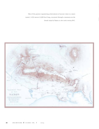
  • 1. One of the greatest engineering achievements of ancient times is a water tunnel, 1,036 meters (4,000 feet) long, excavated through a mountain on the Greek island of Samos in the sixth century B.C. ..,... ........ I ..- -,. " '. .- II,,· 110,· I ,... .- I"h" ... .. d, .. "'I., t . , . S SA 1'10 S 'IOS --- .. -. -----::- ~...~ ... 1oj" 1..-,, .-" "II hb .~ E N G I N E E R I N G & S C I E N C E N O . 1  -. f I" ...·'''r .. " if) >- ~(. I no .. ,' ,~ ..- '" - ...... ~ '.- '~1 . " , .....,;.~ ~..-: " ~11=. . :Iftll l, lB. -. 'illl ,. .J.• .1::..~. ~, ' ''~-:= £i ,... .... ,~ ­ . -'-' '.c...·oJ .. '" 30 ...... - f .. --."-- ..... ,. Ii'I" ...... ',h".. 'f" '" "-I:. - ,e...... , • -- - .'q.- - -- ",. I . , >.:, -
  • 2. The Tunnel of Samos by Tom M. Apostol Facing page: This 1884 map by Ernst Fabricius shows the tunnel running obliquely through the hill marked as Kastro, now Mount Castro. The small fishing village of Tigáni has since been renamed Pythagorion. The cutaway view through Mount Castro at the top of this page comes from a detailed 1995 survey by the German Archaeological Institute in Athens. Below: Hero of Alexandria’s theoretical method for working out the line of a tunnel dug simultaneously from both ends. One of the greatest engineering achievements of ancient times is a water tunnel, 1,036 meters (4,000 feet) long, excavated through a mountain on the Greek island of Samos in the sixth century B.C. It was dug through solid limestone by two separate teams advancing in a straight line from both ends, using only picks, hammers, and chisels. This was a prodigious feat of manual labor. The intellectual feat of determining the direction of tunneling was equally impressive. How did they do this? No one knows for sure, because no written records exist. When the tunnel was dug, the Greeks had no magnetic compass, no surveying instruments, no topographic maps, nor even much written mathematics at their disposal. Euclid’s Elements, the first major compendium of ancient mathematics, was written some 200 years later. There are, however, some convincing explanations, the oldest of which is based on a theoretical method devised by Hero of Alexandria five centuries after the tunnel was completed. It calls for a series of right-angled traverses around the mountain beginning at one entrance of the proposed tunnel and ending at the other, maintaining a constant elevation, as suggested by the diagram below left. By measuring the net distance traveled in each of two perpendicular directions, the lengths of two legs of a right triangle are determined, and the hypotenuse of the triangle is the proposed line of the tunnel. By laying out smaller similar right triangles at each entrance, markers can be used by each crew to determine the direction for tunneling. Later in this article I will apply Hero’s method to the terrain on Samos. Hero’s plan was widely accepted for nearly 2,000 years as the method used on Samos until two British historians of science visited the site in 1958, saw that the terrain would have made this method unfeasible, and suggested an alternative of their own. In 1993, I visited Samos myself to investigate the pros and cons of these two methods  for a Project MATHEMATICS! video program, and realized that the engineering problem actually consists of two parts. First, two entry points have to be determined at the same elevation above sea level; and second, the direction for tunneling between these points must be established. I will describe possible solutions for each part; but first, some historical background. Samos, just off the coast of Turkey in the Aegean Sea, is the eighth largest Greek island, with an area of less than 200 square miles. Separated from Asia Minor by the narrow Strait of Mycale, it is a colorful island with lush vegetation, beautiful bays and beaches, and an abundance of good spring water. Samos flourished in the sixth century B.C. during the reign of the tyrant Polycrates (570–522 B.C.), whose court attracted poets, artists, musicians, philosophers, and mathematicians from all over the Greek world. His capital city, also named Samos, was situated on the slopes of a mountain, later called Mount Castro, dominating a natural harbor and the narrow strip of sea between Samos and Asia Minor. The historian Herodotus, who lived in Samos in 457 B.C., described it as the most famous city of its time. Today, the site is partly occupied by the seaside village of Pythagorion, named in honor of Pythagoras, the mathematician and philosopher who was born on Samos around E N G I N E E R I N G & S C I E N C E N O . 1 31
  • 3. Clockwise from left: A well-preserved portion of the massive ring of fortifications surrounding the ancient capital; the impressive breakwater of Pythagorion; the church in Agiades that now sits atop Eupalinos’s colonnaded reservoir; and a view of this tiny hamlet from the south. (Agiades photos courtesy of Jean Doyen.) 572 B.C. Pythagoras spent little of his adult life in Samos, and there is no reason to believe that he played a role in designing the tunnel. Polycrates had a stranglehold on all coastal trade passing through the Strait of Mycale, and by 525 B.C., he was master of the eastern Aegean. His city was made virtually impregnable by a ring of fortifications that rose over the top of the 900foot Mount Castro. The massive walls had an overall length of 3.9 miles and are among the best-preserved in Greece. To protect his ships from the southeast wind, Polycrates built a huge breakwater to form an artificial harbor. To honor Hera, queen of the Olympian gods, he constructed a magnificent temple that was supported by 150 columns, each more than 20 meters tall. And to provide his city with a secure water supply, he carved a tunnel, more than one kilometer long, two meters wide, and two meters high, straight through the heart of Mount Castro. Delivering fresh water to growing populations has been an ongoing problem since ancient times. There was a copious spring at a hamlet, now known as Agiades, in a fertile valley northwest of the city, but access to this was blocked by Mount Castro. Water could have been brought around the mountain by an aqueduct, as the Romans were to do centuries later from a different source, but, aware of the dangers of having a watercourse 32 E N G I N E E R I N G & S C I E N C E N O . 1  exposed to an enemy for even part of its length, Polycrates ordered a delivery system that was to be completely subterranean. He employed a remarkable Greek engineer, Eupalinos of Megara, who designed an ingenious system. The water was brought from its source at Agiades to the northern mouth of the tunnel by an underground conduit that followed an 850-meter sinuous course along the contours of the valley, passing under three creek beds en route. Once inside the tunnel, whose floor was level, the water flowed in a sloping rectangular channel excavated along the eastern edge of the floor. The water channel then left the tunnel a few meters north of the southern entrance and headed east in an underground conduit leading to the ancient city. As with the northern conduit, regular inspection shafts trace its path. The tunnel of Samos was neither the first nor the last to be excavated from both ends. Two other famous examples are the much shorter, and very sinuous, Tunnel of Hezekiah (also known as the Siloam tunnel), excavated below Jerusalem
  • 4. around 700 B.C., and a much longer tunnel under the English Channel completed in 1994. The Tunnel of Hezekiah required no mathematics at all (it probably followed the route of an underground watercourse), the Tunnel of Samos used very little mathematics, while the Channel Tunnel used the full power of modern technology. There is no written record naming the engineers for Hezekiah’s tunnel, just as there is none for the pyramids of Egypt, most cathedrals of Europe, or most dams and bridges of the modern world. Eupalinos was the first hydraulic engineer whose name has been preserved. Armed only with intellectual tools, he pulled off one of the finest engineering achievements of ancient times. No one knows exactly how he did it. But there are several possible explanations, and we begin with Hero’s method. Hero, who lived in Roman Alexandria in the first century A.D., founded the first organized school of engineering and produced a technical encyclopedia describing early inventions, together with clever mathematical shortcuts. One of history’s most ingenious engineers and applied mathematicians, Hero devised a theoretical method for aligning a level tunnel to be drilled through a mountain from both ends. The contour map on the right shows how his method could be applied to the terrain on Samos. This map is part of a detailed, comprehensive 250-page report published in 1995 by Hermann Kienast, of the German Archaeological Institute in Athens. The sloping dashed line on the map shows the tunnel direction to be determined. Using Hero’s method, start at a convenient point near the northern entrance of the tunnel, and traverse the western face of the mountain along a piecewise rectangular path (indicated in red) at a constant elevation above sea level, until reaching another convenient point near the southern entrance. Measure the total distance moved west, then subtract it from the total distance moved east, to determine one leg of a right triangle, shown dashed on the map, whose hypotenuse is along the proposed line of the tunnel. Then add the lengths of the north-south segments to calculate the length of the other leg, also shown dashed. Once the lengths of the two legs are known, even though they are buried beneath the mountain, one can lay out smaller horizontal right triangles on the terrain to the north and to the south (shown in orange) having the same shape as the large triangle, with all three hypotenuses on the same line. Therefore, workers can always look back to markers along this line to make sure they are digging in the right direction. This remarkably simple and straightforward method has great appeal as a theoretical exercise. But to apply it in practice, two independent tasks need to be carried out with great accuracy: (a) maintain a constant elevation while going around the mountain; and (b) determine a right We can get an idea of working conditions in the tunnel from this Greek mining scene depicted on a tile found near Corinth. AGIADES UNDERGROUND CONDUIT NORTHERN ENTRANCE 40 60 80 100 120 140 FORTIFICATIONS 160 SOUTHERN ENTRANCE This schematic diagram shows how Hero’s method can be applied to the terrain on Samos. The hypotenuse of the large right triangle is the line of the proposed tunnel. Markers can be put along the hypotenuses of the small right triangles at each entrance to help the tunnelers dig in the right direction.  E N G I N E E R I N G & S C I E N C E N O . 1 33
  • 5. Clay gutters like these were found in the bottom of the tunnel’s water channel. They could have been joined at right angles by L-shaped pieces, and used as leveling gutters around the mountain. 34 E N G I N E E R I N G angle when changing directions. Hero suggests doing both with a dioptra, a primitive instrument used for leveling and for measuring right angles. His explanation, including the use of the dioptra, was widely accepted for almost two millennia as the method used by Eupalinos. It was publicized by such distinguished science historians as B. L. van der Waerden and Giorgio de Santillana. But because there is no evidence to indicate that the dioptra existed as early as the sixth century B.C., other scholars do not believe this method was used by Eupalinos. To check the feasibility of Hero’s method, we have to separate the problems of right angles and leveling. First, consider the problem of right angles. The Samians of that era could construct right angles, as evidenced by the huge rectangular stones in the beautifully preserved walls that extended nearly four miles around the ancient capital. Dozens of right angles were also used in building the huge temple of Hera just a few miles away. We don’t know exactly how they determined right angles, but possibly they constructed a portable rectangular frame with diagonals of equal length to ensure perpendicularity at the corners. A carpenter’s square appears in a mural on a tomb at Thebes, dating from about 1450 B.C., so it’s reasonable to assume that the Samians had tools for constructing right angles, although the accuracy of these tools is uncertain. In practice, each application of such a tool (the dioptra included) necessarily introduces an error of at least 0.1 degree in the process of physically marking the terrain. The schematic diagram on page 33 shows a level path with 28 right angles that lines up perfectly on paper, but in practice would produce a total angular error of at least two degrees. This would put the two crews at least 30 meters apart at the proposed junction. Even worse, several of these right angles would have to be supported by pillars 10 meters high to maintain constant elevation, which is unrealistic. A level path with pillars no more than one meter high would require hundreds of right angles, and would result in huge errors in alignment. Therefore, because of unavoidable errors in marking right angles, Hero’s method is not accurate enough to properly align the small right triangles at the two entrances. As for leveling, one of the architects of the temple of Hera was a Samian named Theodoros, who invented a primitive but accurate leveling instrument using water enclosed in a rectangular clay gutter. Beautifully designed round clay pipes from that era have been found in the underground conduit outside the tunnel, and open rectangular clay gutters in the water channel inside the tunnel. So the Samians had the capability to construct clay gutters for leveling, and they could have used clay L-shaped pieces for joining the gutters at right angles, as suggested in the illustration on the left. With an ample supply of limestone slabs available, and a few skilled stonemasons, & S C I E N C E N O . 1  The southern entrance to the tunnel is somewhere within the circle, in a grove of trees. The yellow line shows the approximate route a straight path directly above the tunnel would take over the south face of Mount Castro; it’s a fairly easy climb. Eupalinos could have marked the path with a series of layered stone pillars capped by leveling gutters that maintained a constant elevation while going around the mountain, thereby verifying constant elevation with considerable accuracy. In 1958, and again in 1961, two British historians of science, June Goodfield and Stephen Toulmin, visited the tunnel to check the practicability of Hero’s theory. They studied the layout of the surrounding countryside and concluded that it would have been extremely laborious—if not actually impossible—to carry out Hero’s method along the 55-meter contour line that joins the two entrances, because of ravines and overhangs. They also noticed that the tunnel was built under the only part of the mountain that could be climbed easily from the south, even though this placed it further from the city center, and they suggested that an alternative method had been used that went over the top, as shown in the photo above. Armed with Goodfield and Toulmin’s analysis, I checked the feasibility of Hero’s method. It’s true that the terrain following the 55-meter contour is quite rough, especially at the western face of the mountain. But just a few meters below, near the 45-meter contour, the ground is fairly smooth, and it is easy to follow a goat trail through the brambles in a westerly direction around the mountain. Eupalinos could have cleared a suitable path along this terrain and marked it with stone pillars, keeping them at a constant elevation with clay leveling gutters, as described earlier, or with some other leveling instrument. At the western end of the south face, the terrain gradually slopes down into a stream-
  • 6. Above: Mamikon Mnatsakanian holds high his invention, the leveling bow, while Tom Apostol (left) and our own Doug Smith (right) check each end. The diagram shows a handheld lever that can be used to stabilize the bow and fine-tune its elevation. bed that is usually dry. An easy walk along this streambed leads to the northern face and a gentle slope up toward the northern entrance of the tunnel. Not only is the path around the mountain almost level near the 45-meter contour, it is also quite short—from one tunnel entrance to the other is at most only 2,200 meters. Goodfield and Toulmin suggested that the most natural way to establish a line of constant direction would be along the top of the mountain, driving a line of posts into the ground up one face of the hill, across the top, and down the other, aligning the posts by eye. To compare elevations on the two sides of the hill, they suggested measuring the base of each post against that immediately below it, using a level. This approach presents new problems. First, it is difficult to drill holes in the rocky surface to install a large number of wooden posts. Second, aligning several hundred posts by eye on a hillside is less accurate than Hero’s use of right angles. Keeping track of differences in elevation is also very difficult. There is a greater chance of error in measuring many changes in elevation along the face of a hill than there would be in sighting horizontally going around on a path of constant elevation. Because errors can accumulate when making a large number of measurements, Eupalinos must have realized that going over the top with a line of posts would not give a reliable comparison of altitude. To ensure success, he knew it was essential for the two crews to dig along a nearly level line joining the two entrances. The completed tunnel shows that he did indeed establish such a line,  with a difference of only 60 centimeters in elevation at the junction of the north and south tunnels, so he must have used a leveling method with little margin for error. Water leveling with clay gutters, as described earlier, provides one accurate method, but there are other methods that are easier to carry out in practice. Recently, my colleague Mamikon Mnatsakanian conceived an idea for another simple leveling tool that could have been used, a long wooden bow suspended by a rope from a central balancing point so that its ends are at the same horizontal level. The bow need not have uniform thickness and could be assembled by binding together two lengthy shoots from, say, an olive tree. Such a bow, about eight meters long, would weigh about four pounds and would be easy to carry. And it has the advantage that no prior calibration is needed. To use the bow as a leveling tool, place it on the ground and slowly lift it with the rope. If the two ends leave the ground simultaneously, they are at the same elevation. If one end leaves the ground first, place enough soil or flat rock beneath that end until the other end becomes airborne. At that instant, the bow will oscillate slightly, which can be detected visually, and the two ends will be at the same elevation. Three people are needed, one at the center and one at each end to fix the level points. To check the accuracy, turn the bow end-to-end and make sure both ends touch at the same two marks. In this way, the device permits self-checking and fine tuning. There will be an error in leveling due to a tiny gap between the endpoint of the bow and the point on which it is supposed to rest when level; this can be checked E N G I N E E R I N G & S C I E N C E N O . 1 35
  • 7. By sighting horizontally along the tops of two pillars set eight meters apart, a target point can be located up to 100 meters away; a possible error of two millimeters in the elevations of the two pillars expands to an error of 25 8m millimeters in the elevation of the target point. by the human eye at close range, and would be one or two millimeters per bow length. To employ the leveling bow to traverse Mount Castro at constant elevation, one can proceed as follows. Construct two stone pillars, eight meters apart, and use the leveling bow to ensure that the tops of the pillars are at the same elevation. At the top of each pillar, a horizontal straightedge can be used for visual sighting to locate other points at the same elevation and on the same line—the same principle as used for aiming along the barrel of a rifle. Points approximately at the same elevation can be sighted visually at great distances. Choose such a target point and construct a new pillar there with its top at the same elevation, and then construct another pillar eight meters away to sight in a new direction, using the leveling bow to maintain constant elevation. Continuing in this manner will produce a polygonal path of constant elevation. The contour map on the right shows such a path in green, with only six changes in direction leading from point B near the northern entrance to point D near the southern entrance. The distance around Mount Castro along this path is less than 2,200 meters (275 bow lengths), so an error of two millimeters per bow length could give a total leveling error of about 55 centimeters. This is close to the actual 60-centimeter difference in floor elevation measured at the junction inside the tunnel. In contrast to Hero’s method, no angular or linear measurements are needed for leveling with Mamikon’s bow. Without Hero’s method, how could Eupalinos locate the entry points and fix the direction for tunneling? Kienast’s report offers no convincing theory about this, but using information in the report, Mamikon and I propose another method that could have determined both entries, and the direction of the line between them, with considerable accuraccy. Kienast’s contour map (right) 36 E N G I N E E R I N G & S C I E N C E N O . 1 AGIADES UNDERGROUND CONDUIT N B A NORTHERN ENTRANCE 40 60 80 100 120 140 FORTIFICATIONS 160 180 T SOUTHERN ENTRANCE C D S Using pillars and the leveling bow, a polygonal path, in green, can be traced around the mountain at a constant elevation above sea level to join point B near the northern entrance to point D near the southern. 
  • 8. From a point seven meters above the top of the profile, there is a direct line of sight to Agiades in the north and the seashore to the south. It would have been easy for Eupalinos to build a surveying tower (T ) there. Two sighting poles such as the ones shown below could have been installed on the tower to align with markers N and S in Agiades and on the shore, respectively. shows that the north entrance to the tunnel, point A on the map, lies on the 55-meter contour line, and the source at Agiades is near the same contour line. His profile map in the report, which I have adapted for the diagram above, reveals that persons standing at the crest of the mountain cannot see Agiades in the north and the seashore in the south at the same time—but they could if they were on top of a seven-meter-high tower at point T. The Samians could easily have constructed such a tower from wood or stone. Mamikon has conceived a sighting tool, based on the same principle as the Roman groma, that could have been used to align T with two points: one (N) near the source in the northern valley and one (S) on the seashore in the south within the city walls. This sighting tool consists of a pair of two-meter-high “fishing poles” about five meters apart, with a thin string hanging vertically from the top of each pole to which a weight or plumb 2m 5m 7m bob has been attached. Each pole would be mounted on the tower so that it could turn around a vertical axis, allowing the hanging strings to be aligned by eye while aiming toward a person or marker at point N. Sighting along the same device in the opposite direction locates S. Using the same type of sighting instrument from point N, and sighting back toward T, the tunnel’s northern entrance (point A) can be chosen  so that S, T, N, and A are in the same vertical plane. Then the leveling bow can be used to ensure that A is also at the same elevation as N. For the southern entrance, we need a point C inside the city walls at exactly the same elevation as A. Starting from a nearby point B at a lower elevation easier to traverse and in the vertical plane through N and A, a series of sighting pillars can be constructed around the western side of the mountain—using any of the leveling methods described earlier—until point D, at the intersection of the sighting plane through T and S, is reached. The two terminal points B and D will be at the same elevation above sea level, and the vertical plane through points B, T, and D fixes the line for tunneling. It is then a simple matter to sight a level line from the top of a pillar at D to determine the southern entrance point, C, that has the same elevation as A. Markers could be placed along a horizontal line of sight at each entrance to guide the direction of excavation. How accurate is this method of alignment? In sighting from one fishing pole to its neighbor five meters away, there is an alignment error of one millimeter, which expands to an overall error of 22 centimeters in sighting from point T at the top of the mountain to point N, 1,060 meters away to the north, plus another error of 13 centimeters from T to S, 644 meters away to the south. So the total error in sighting from N to S by way of T is of the order of 35 centimeters. Adjusting this to account for the alignment error from N to A by way of B, and from S to C by way of D, gives a total error of the order of less than 50 centimeters between the two directions of tunneling. This is well within the accuracy required to dig two shafts, each two meters wide, and have them meet, and is much more accurate than the other proposed methods of alignment. Moreover, as with the alternative method of leveling, no angular or linear measurements are needed. E N G I N E E R I N G & S C I E N C E N O . 1 37
  • 9. This picture was taken inside the tunnel looking toward the southern entrance. Although the floor is more or less level along the whole length, the roof slopes in line with the rock strata. Metal grillwork now covers the water channel on the left to prevent hapless tourists from falling in; the photo on the next page shows how treacherous it was before. The crew digging into the northern mountainside started off perfectly in line with the southern crew, but later zigzagged off course, perhaps to bypass areas of unstable rock. They did, however, meet up almost perfectly with the southern tunnel, albeit at right angles. Right: At the southern end, the water channel is a staggering nine meters lower than the floor of the tunnel. 38 E N G I N E E R I N G No matter how it was planned, the tunnel excavation itself was a remarkable accomplishment. Did the two crews meet as planned? Not quite. If the diggers had kept faith in geometry and continued along the straight-line paths on which they started, they would have made a nearly perfect juncture. The path from the north, however, deviates from a straight line. When the northern crew was nearly halfway to the junction point, they started to zigzag as shown in the diagram on the left, changing directions several times before finally making a sharp left turn to the junction point. Why did they change course? No one knows for sure. Perhaps to avoid the possibility of digging two parallel shafts. If one shaft zigzagged while the other continued in a straight line, intersection would be more likely. Or they may have detoured around places where water seeped in, or around pockets of soft material that would not support the ceiling. In the final stretch, when the two crews were near enough to begin hearing each other, both crews changed direction as needed and came together. The sharp turns and the difference in floor levels at the junction prove conclusively that the tunnel was excavated from both ends. At the junction itself, the floor level drops 60 centimeters from north to south, a discrepancy of less than one-eighth of a percent of the distance excavated. This represents an engineering achievement of the first magnitude. No one knows exactly how long it took to complete the project, but estimates range from 8 to 15 years. Working conditions during excavation must have been extremely unpleasant. Dust from rubble, and smoke from oil lamps used for illumination, would have presented serious ventilation problems, especially when the workers had advanced a considerable distance from each entrance. & S C I E N C E N O . 1  A visit to the tunnel today reveals its full magnificence. Except for some minor irregularities, the southern half is remarkably straight. The craftsmanship is truly impressive, both for its precision and its high quality. The tunnel’s two-meter height and width allowed workers carrying rubble to pass those returning for more. The ceiling and walls are naked rock that gives the appearance of having been peeled off in layers. Water drips through the ceiling in many places and trickles down the walls, leaving a glossy, translucent coating of calcium carbonate, but some of the original chisel marks are still visible. The floor is remarkably level, which indicates that Eupalinos took great care to make sure the two entrances were at the same elevation above sea level. Of course, a level tunnel cannot be used to deliver a useful supply of water. The water itself was carried in a sloping, rectangular channel excavated adjacent to the tunnel floor along its eastern edge. Carving this inner channel with hand labor in solid rock was another incredible achievement, considering the fact that the walls of the channel are barely wide enough for one person to stand in. Yet they are carved with great care, maintaining a constant width throughout. At the northern end, the bottom of the channel is about three meters lower than the tunnel floor, and it gradually slopes down to more than nine meters lower at the southern end. The bottom of the channel was lined with open-topped rectangular clay gutters like those in the drawing on page 34.
  • 10. Jane Apostol descends the dauntingly narrow wooden staircase near the southern entrance, far left, which leads to a narrow walled passageway whose gabled roof is typical of ancient Greek construction, near left. Below: This old photo of the tunnel, looking north, shows the open water channel. Part of the channel above the water gutters was originally filled in with rubble, some of which is still visible. When the tunnel was rediscovered in the latter part of the 19th century and partially restored, portions of the water channel were found to be covered with stone slabs, located two to three meters above the bottom of the channel, onto which excess rubble from the excavation had been placed up to the tunnel floor. The generous space below the slabs along the bottom of the channel provided a conduit large enough for ample water to flow through, and also permitted a person to enter for inspection or repairs. In several places the channel was completely exposed all the way up to the tunnel floor, permitting inspection without entering the channel. Today, most of the rubble has been cleared from the southern half of the channel, and metal grillwork installed to prevent visitors from falling in. To visit the tunnel today, you first enter a small stone building erected in 1882 at the southern entrance. A narrow, rectangular opening in the floor contains a steep flight of wooden steps leading down into a walled passageway about 12 meters long, slightly curved, and barely wide enough for one person to walk through. The sides of the passageway are built of stone blocks joined without mortar, and capped by a gabled roof formed by pairs of huge, flat stones leaning against each other in a manner characteristic of ancient Greek construction. This passageway was constructed after the tunnel had been completely excavated. Excess rubble from the excavation, which must have been considerable, was used to cover the roof of this passageway, and a similar one at the north entrance, to camouflage them for protection against enemies or unwelcome intruders. Electric lights now illuminate the southern half, up to a point about 100 meters north of the junction with the northern tunnel, where there is a barrier and landfall that prohibits visitors from going further.  E N G I N E E R I N G & S C I E N C E N O . 1 39
  • 11. Modern stone walls now line the path near the northern entrance of the tunnel, left, while inside, right, a stone staircase leads down to the tunnel. PICTURE CREDITS: 3031, 33, 36, 38 – German Archaeological Institute; 32-34, 38-40 – Tom Apostol; 35 – Bob Paz; 39 – Hellenic TAP Service For centuries, the tunnel kept its secret. Its existence was known, but for a long time the exact whereabouts remained undiscovered. The earliest direct reference appears in the works of Herodotus, written a full century after construction was completed. Artifacts found in the tunnel indicate that the Romans had entered it, and there is a small shrine near the center from the Byzantine era (ca. A.D. 500–900). In 1853, French archaeologist Victor Guérin excavated part of the northern end of the subterranean conduit, but stopped before reaching the tunnel itself. An abbot from a nearby monastery later discovered the northern entrance and persuaded the ruler of the island to excavate it. In 1882, 50 men restored the southern half of the tunnel, the entire northern underground conduit, and a portion of the southern conduit. On the foundation of an ancient structure, they built a small stone house that today marks the southern entrance. In 1883, Ernst Fabricius of the German Archaeological Institute in Athens surveyed the tunnel and published an excellent description, including the topographic sketch shown on page 30. The videotape on the Tunnel of Samos has been a favorite of the educational Project MATHEMATICS! series (www.projectmathematics.com) created, directed, and produced by Professor of Mathematics, Emeritus, Tom Apostol. He is, however, better known to students both here and abroad as the author of textbooks in calculus, analysis, and number theory, books that have had a strong influence on an entire generation of mathematicians. After taking a BS (1944) and MS (1946) at the University of Washington, he moved to UC Berkeley for his PhD (1948), then spent a year each at Berkeley and MIT before joining Caltech in 1950. Although he became emeritus in 1992, his mathematical productivity has not slowed down—he has published 40 papers since 1990, 16 of them jointly with Mamikon Mnatsakanian. This lone survivor is one of 150 columns, each more than 20 meters tall, that once supported the Temple of Hera, lauded by Herodotus as one of the three greatest engineering feats of ancient times. The other two were also on Samos—the breakwater and the tunnel. 40 E N G I N E E R I N G After that, the tunnel was again neglected for nearly a century, until the Greek government cleared the southern half, covered the water channel with protective grillwork, and installed lighting so tourists could visit it safely. Today, the tunnel is indeed a popular tourist attraction, and a paved road from Pythagorion leads to the stone building at the southern entrance. Some visitors who enter this building go no further because they are intimidated by the steep, narrow, and unlit wooden staircase leading to the lower depths. At the north entrance, which can be reached by hiking around Mount Castro from the south, modern stone walls lead to a staircase and passageway. A portion of the northern tunnel has been cleared, but not lighted. The tunnel, the seawall protecting the harbor, and the nearby temple of Hera—three outstanding engineering achievements—were constructed more than 2,500 years ago. Today, the tunnel and seawall survive, and although the temple lies in ruins, a single column still stands as a silent tribute to the spirit and ingenuity of the ancient Greeks. ■ & S C I E N C E N O . 1 