

Empfohlen
Empfohlen
Weitere ähnliche Inhalte
Ähnlich wie Drone shadow-handbook
Ähnlich wie Drone shadow-handbook (17)
Mehr von Geoffrey Dorne
Mehr von Geoffrey Dorne (20)
Kürzlich hochgeladen
Kürzlich hochgeladen (20)
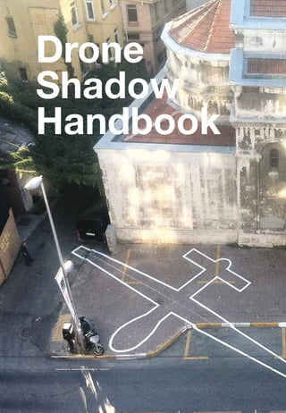
Drone shadow-handbook
- 2. Introduction to the Drone Shadows The Drone Shadows are a series of installations, comprising of the outline of an unmanned aerial vehicle (UAV), or drone: a 1:1 representation conveying both the physical reality, and the apparent invisibility, of drone aircraft. You can draw drones too. The first Drone Shadow was drawn by myself and Einar Sneve Martinussen in London, in January 2012. Since then, I have painted more in Istanbul, Brighton, and Washington DC. A commissioned shadow in Brisbane in 2013 was censored by the state government, but others have been created in Sao Paolo, Detroit and elsewhere. This handbook is a guide to creating more. Why would you want to draw a drone? Drones are used in wars and covert operations worldwide, by many countries. They are used to surveil, to fight, to assassinate, to police, to deter migrants - and to study hurricanes and fight forest fires. But they remain largely invisible, in part due to the manner of their operation, flying for long periods high in the atmosphere, and in part because the political motivations for their use prefer to remain obscure. Drones are avatars of the the political process: they are instantiations of a set of ideologies and beliefs, made visible when they are built into electromechanical systems. When we talk about drones, we are really talking about the politics that demand, shape, and deploy them, and the politics which are made possible by them. This politics reflects the drones themselves: it is a politics of violence, of obfuscation, of radical inequality of sight and action, and it is sustained by that obfuscation and that inequality. The Drone Shadow is not just a picture of a drone. It is a diagram of a political system. Drones are also avatars of all of the invisible, networked systems that surround us on a daily basis. They stand in for the internet, for social media, for every remote connection we make. Like the internet, they allow us to see and act at a distance - but they may also be used against us and others. In order to understand the world around us, we sometimes need to draw it out. If you can’t really describe the world around you, you can’t fully act in it, and are made powerless. When you can describe it, you can debate and critique it. Drawing its shadow is just the first step. James Bridle http://booktwo.org London November 2013 Front cover: Drone Shadow 002, James Bridle, Istanbul, 2012; Right, from top: Drone Shadow 001, James Bridle & Einar Sneve Martinussen, London, 2012; Drone Shadow 003, James Bridle, Brighton, 2013; Drone Shadow 004, James Bridle, Washington DC, 2013; Rear cover: Drone Shadow, Sao Paolo, installed by Elo3 for Mostra 3M de Arte Digital.
- 4. Drawing a Drone Shadow Anyone can create a Drone Shadow, and this book contains plans for a number of different types of drone, and some basic instructions for drawing them. There are a few guidelines however, which are important, to keep the shadows consistent and legible. • Drone Shadows should be 1:1 representations: they should be the exact dimensions of real drones, according to the measurements in the schematics here or ones you create yourself. They should not be drawn larger or smaller than life for convenience or effect. This is because they are intended to convey the reality of the size and shape of actual drones. • Drone Shadows should be outlines, not filled in shapes. This outline is typically 5-10cm (3-4in) thick, but this can be varied. • Drone Shadows should be locally relevant, where possible. The choice of shadow should reflect the concerns of the place where it is drawn. Wherever you’re drawing the drone, consider the local context and politics. Which aircraft are operated by the country you’re in, or have been used by or in it? Which aircraft are currently in the news? If there’s no schematic for the one you want to draw, research and sketch it yourself.
- 6. Materials and Placement It’s possible to create the Drone Shadows from a range of materials. Shadows have been created using chalk, spray-paint, professional road-marking materials, and tape. In choosing materials, you should consider how visible you want the Drone Shadow to be, and how long it should be visible for. Chalk and some types of paint will be removed quickly by the weather. Chalk and tape can be easily removed by others as well. If using paint, first outline the shadow with tape to make a stencil. There are professional road markers who are experienced in creating shapes on streets, parks and elsewhere: just search the Internet for “line painters” in your areas. White is the strongest colour for drawing with on dark surfaces, and stands out the best during the day and night. The more contrast with the surrounding surface, the more visible the shadow will be. When choosing the location for the shadow, consider how it will be viewed. The heavier the traffic in the area, the more people will see it. The shadows are particularly striking when viewed from above, so consider drawing it near a higher viewing position, such as a bridge, public balcony, or steps. Right, from top: Chalk drone shadow on concrete; Professional road-marking with paint and tape stencil on paving; Professional road-marking with paint and chalk guidelines on tarmac; Spray-paint with tape stencil on paving and gravel.
- 8. How to draw a Drone Shadow In addition to the marking materials you are using to draw the drone —chalk, tape, paint, etc.—you also need the tools for creating the outline. A tested way of doing this is as follows. 1. First, work out the total area the shadow will cover: wingtip to wingtip, and nose to tail. This will be a cross shape in the area you want to mark. 2. On this cross, find the centre point where the wings cross the body of the aircraft. 3. Draw in the wing box of the aircraft: this is the area between the wings and across the body, from which you can extend out to the wings, forward to the nose, and backwards to the tail. (This is not a permanent marking - don’t paint this.) 4. When the wing box is positioned, sketch out the rest of the aircraft in chalk or tape, prior to painting. 5. If painting, create two sets of lines around the aircraft shape in tape, as a stencil to fill in. 6. When the whole aircraft has been sketched, you can thicken the lines with tape or chalk, or paint in the stencil. For this, you will need a long measuring tape, and straight and right edges (flat and L-shaped rulers: the first for making straight lines, the second for making right angles. You can use anything as a right edge, such as a box or piece of paper). Chalk line is very helpful for making long straight lines: this is string covered in chalk, which is drawn tight between two points and snapped onto the ground to leave a faint chalk mark.
- 9. 1. Mark cross. 2. Find centre of wings and body. 3. Sketch wing box. 4. Extend wing box to complete outline. 5. Create stencil for painting, if required.
- 10. Drone Shadow Schematics The following pages contain schematics of four drones which are in use around the world today. Their relative sizes are shown opposite. 1. The General Atomics MQ-1 Predator is a medium-altitude, longendurance (MALE) unmanned aircraft system. Developed in the 1990s, it has seen service in the Balkans, Iraq and Afghanistan with US Forces, and is also operated by the CIA, the UK, Italy, Morocco; and has been ordered by Turkey and the UAE. It operates as a surveillance platform, but can also be armed with Hellfire and other missiles, cruising for up to 24 hours at up to 25,000 feet, at 100mph, with a range of 675 miles. 2. The General Atomics MQ-9 Reaper is a larger, heavier development of the Predator, flying higher, faster and further (up to 300 mph at 50,000 feet, for 14 hours, with a range of 1,150 miles). The Reaper is a “hunter-killer” UAV designed as a surveillance and weapons platform. It is operated by the US, UK, Australia, France, and NASA. 3. The Northrop Grumman RQ-4 Global Hawk is the largest unmanned aircraft currently flying. It is unarmed, but carries sophisticated cameras and communication equipment, allowing it to survey vast areas and act as a relay for ground troops, commanders and other aircraft, supporting targeting and battles. It can fly at up to 60,000 feet for as long as 28 hours, with a range of 8,700 miles, allowing it to photograph up to 40,000 square miles of terrain a day. 4. The Elbit Systems Hermes 450 is an Israeli-built medium size multi-payload unmanned aerial vehicle designed for tactical long endurance missions. It has an endurance of over 20 hours, with a primary mission of reconnaissance, surveillance and communications relay. It flown by Azerbaijan, Botswana, Brazil, Colombia, Croatia, Cyprus, Georgia, Mexico, Singapore, Israel, the UK and the United States Border Patrol. It is also the basis for the British Army’s Thales Watchkeeper WK450.
- 11. 2. Reaper 3. Global Hawk 1. Predator 4. Hermes
- 14. 3m 2.8m 1.6m 3.4m Global Hawk / RQ-4A 2.7m 0.8m 16.975m 0.52m 35.4m 1.45m 0.66m 1.92m 0.4m 13.5m 0.4m 0.6m
- 15. 0.6m 1.55m 0.5m 10.5m 2.8m Hermes 450 / Watchkeeper WK450 5m 1.7m 0.44m 0.55m 0.36m 0.2m 6.1m
- 16. Drones - unmanned aerial vehicles - are becoming ubiquitous, yet remain almost invisible. This is a guide to drawing them. James Bridle Visit http://booktwo.org to find out more This PDF is released under Creative Commons You are free to share it, and to print and reproduce it without changes for non-commercial purposes and with attribution intact.