Volcanic dam at Mount Meager
•
1 gefällt mir•1,891 views

A presentation on the construction and destruction of a volcanic dam at Mount Meager, BC, 2400 years ago.

Empfohlen
Weitere ähnliche Inhalte
Ähnlich wie Volcanic dam at Mount Meager
Ähnlich wie Volcanic dam at Mount Meager (20)
Kürzlich hochgeladen
Kürzlich hochgeladen (20)
Volcanic dam at Mount Meager
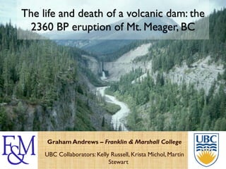
- 1. The life and death of a volcanic dam: the 2360 BP eruption of Mt. Meager, BC Graham Andrews – Franklin & Marshall College UBC Collaborators: Kelly Russell, Krista Michol, Martin Stewart
- 2. • Why study volcanic dams? natural dams 101 how do dams fail? when dams fail… • Mount Meager and the 2360 BP eruption Outline non-volcanic debris flows • Volcaniclastic stratigraphy and dam architecture • Welded vs . non-welded porosity compaction • Paleo-Salal Lake • Lessons for the future?
- 3. The 2360 BP eruption of Mt. Meager gives us a unique opportunity to explore: This study 1. the volcanic damming (and failure) process, 2. the timescales of damming and failure, 3. the influence of changing properties in volcanic dams, and 4. ways to prepare for and mitigate against similar events in the future.
- 4. beaver dam Natural Dams Natural dams form in 3 different ways: Wikipedia biological ESA geological glacial Lake Sarez, Tajikistan
- 5. USGS Natural Dams - Ice Hubbard glacier, AK In 1986 and 2002 the surging Hubbard Glacier temporarily created a 5 km3 “Russell Lake” in 24 hours before it burst. The outburst flood generated was ≤105 m3/s. Lake Missoula floods ≤107 m3/s
- 6. Dams typically fail in 1 of 2 ways: • overtopping, • undermining by seepage. How dams fail 1. - Overtopping gradually but rapidly erodes the top and the downstream side of the dam – like a knick-point migration – until the dam fails. • e.g., “Johnstown Flood”, PA, 1889 – 2,200+ fatalities Wikipedia
- 7. Dams typically fail in 1 of 2 ways: • overtopping, • undermining by seepage. How dams fail 2. - Undermining removes a large section of the dam in one go. It usually follows seepage of water into the porous dam structure or bedrock. e.g., Teton Dam, Fremont and Madison Counties, ID, 1976 St. Francis Dam, CA, 1928 – 450+ fatalities
- 9. dam failure USGS test excavations How dams fail dam remnant flood debris Teton Dam, ID USGS Thick dams are rarely completely destroyed – usually most of the dam is left and the water escapes out the side of the dam.
- 10. USGS
- 11. Dam failure - effects Catastrophic dam failures are devastating to the environment downstream. Outburst floods form debris flow deposits commonly contain house-sized clasts of rock / dam material weighing 10s of metric tons (10,000s of lbs). 13t piece of St. Francis dam Volcanic outburst – ½ mile from source floods and mudflows are called lahars. USGS
- 12. Andrews et al., in prep. Quaternary Garibaldi volcanic belt (GVB) Mount Meager Northernmost of 3 deeply-eroded felsic stratovolcanoes:- Garibaldi, Cayley, and Meager.
- 13. Andrews et al., in prep. Quaternary Garibaldi volcanic belt (GVB) Mount Meager Northernmost of 3 deeply-eroded felsic stratovolcanoes:- Garibaldi, Cayley, and Meager. Part of the Cascade arc and Pacific “Ring of Fire”.
- 14. Andrews et al., in prep. Quaternary Garibaldi volcanic belt (GVB) Mount Meager Northernmost of 3 deeply-eroded felsic stratovolcanoes:- Garibaldi, Cayley, and Meager. Part of the Cascade arc and Pacific “Ring of Fire”. Prospective for geothermal and hydroelectric power.
- 15. The last eruption formed the extensive ‘Bridge River’ tephra (14C - 2360 Mount Meager BP) – the last explosive eruption in Canada. Geological Survey of Canada
- 16. The Meager volcanic complex is a series of Mount Meager 4 edifices built one on top of the other. Each new edifice is further north. The volcano has experienced >5 periods of glaciation. The volcano is highly unstable. Hickson et al., 1999
- 17. Meager Peak With over 1800 Capricorn Plinth Peak (P) – m of relief Mt Peak 2677 m Meager is very Mount Meager rugged and steep. The 2360 BP looking NW vent (V) is in a glacier-filled col ~800 m above the adjacent Lillooet valley floor (1 in 3 gradient). looking SW
- 18. Mount Meager
- 19. Andrews et al., in prep. 2360 BP Pebble Creek Formation Pebble Creek Formation
- 20. Andrews et al., in prep. Pebble Creek Formation misfit stream and canyon
- 21. Keyhole Canyon & misfit Lillooet River slot-canyon = 2300 years of ‘normal’ erosion looking NW - upstream looking SE - downstream 90 m 2000 m 300 m
- 22. The 2360 BP eruption went through 3 major phases: 2360 BP eruption 1. sub-Plinian explosive eruption deposited dacite ash across much of British Columbia. Local pumice fall deposits and thin ignimbrites (pyroclastic flows).
- 23. The 2360 BP eruption went through 3 major phases: 2360 BP eruption 1. sub-Plinian explosive eruption deposited dacite ash across much of British Columbia. Local pumice fall deposits and thin ignimbrites (pyroclastic flows). 2. Vulcanian explosions of a hot lava dome generated welded and non-welded block-and- ash flow deposits.
- 24. The 2360 BP eruption went through 3 major phases: 2360 BP eruption 1. sub-Plinian explosive eruption deposited dacite ash across much of British Columbia. Local pumice fall deposits and thin ignimbrites (pyroclastic flows). 2. Vulcanian explosions of a hot lava dome generated welded and non-welded block-and-ash flow deposits. 3. Collapse of an extrusive dacite lava flow generated more non-welded block-and-ash flow deposits explosive effusive
- 25. Montserrat – Feb 5th 2010 Vulcanian eruptions block & ash flows MVO
- 27. 2360 BP eruption Andrews et al., in prep.
- 28. lake sediments Pebble Creek Formation block & ash deposits lahar deposit Andrews et al., in prep.
- 29. 1 Pebble Creek Formation 2 Event stratigraphy downstream upstream Andrews et al., in prep. 3
- 30. block & ash deposit dam Volcanic dam Michol, Russell, Andrews, JVGR 2008 780 masl 680 masl
- 31. Volcanic dam non-welded B&A welded B&A Michol, Russell, Andrews, JVGR 2008
- 32. Volcanic dam welded B&A • strongly-welded glassy matrix, • blocks of dense dacitic obsidian, • ~31% compacted, • deposited ‘hot’ (>600 °C), • “HARD” like lava Michol, Russell, Andrews, JVGR 2008
- 33. Volcanic dam non-welded B&A • unconsolidated to weakly-indurated ashy matrix; • blocks of dense dacite; • deposited ‘cold’ (<600 °C); • “SOFT” like sand easily eroded
- 35. Welded vs. non-welded bubble-wall shard equant, blocky shard non-welded Michol, Russell, Andrews, JVGR 2008
- 36. Welded vs. non-welded bubble-wall shard equant, blocky shard non-welded welded 1mm deformed pumice lapillus flattened shard
- 37. Welded vs. non-welded non-welded loose to moderately lithified 32 – 40% porosity bulk density 1.4 – 1.5 g/cm3 strongly welded welded 5 – 16% porosity bulk density 2.1 – 2.3 g/cm3 1mm Michol, Russell, Andrews, JVGR 2008
- 38. block & ash deposit dam 1 – rapid filling of the valley by block & ash flow deposits – dam axis ~780 masl 2 – 31% compaction and welding in the B&A deposits – dam axis ~740 masl 3 – dam breached eroded by the outburst flood – canyon floor at 570 masl Andrews et al., in prep.
- 39. 1 Pebble Creek Formation 2 Event stratigraphy downstream upstream Andrews et al., in prep. 3
- 40. Salal Creek delta Paleo-Salal Lake Salal Creek Andrews et al., in prep. top of delta & max elevation of Salal Lake 740 masl Lillooet River valley floor dam 680 masl
- 41. lake reconstruction max dam elevation Paleo-Salal Lake – 780 masl Andrews et al., in prep. delta – 740 masl min dam – 740 masl max Salal Lake - 740 masl Salal Lake volume = original valley floor ~550 x 106 m3 (~0.55 km3) – 570 masl • Salal Lake grew no higher than 740 masl (≤160 m deep) then breached • ¼ the volume of American Falls reservoir
- 42. 1 Pebble Creek Formation 2 Event stratigraphy downstream upstream Andrews et al., in prep. 3
- 43. downstream – lahar deposit Outburst flood polygonal-jointed margins huge, rounded eroded and deposited hot blocks of welded B&A deposit poorly-sorted, non-welded matrix Andrews et al., in prep.
- 44. Keyhole Canyon & misfit Lillooet River cooling joints perpendicular to the canyon walls looking NW - upstream excavated above 600°C looking SE - downstream
- 45. • Salal Lake filled for ~90 days at 161 m3/s (at present flow-rate) WCS model - instantaneous (catastrophic) 6000 m2 opening Outburst flood in the dam [undermining & rapid overtopping] max. elevation of max. volume of Salal dam axis and lake at Lake at failure failure residual lake residual lake elevation volume • Salal Lake drained in ~13 hours; peak deluge flux of ~2.7 x 10⁵ m3/s Andrews et al., in prep.
- 46. volcanism and dam-building Dam evolution 31% viscous compaction in ~90 days Andrews et al., in prep.
- 47. 1. B&A flows rapidly dammed the Lillooet River and created Salal Lake (≤160 m deep), Summary 2. the dam failed after ~90 days, 3. the lake drained catastrophically and generated an outburst flood (lahar) that eroded the canyon, 4. welding was interrupted by dam failure ◦ 31% viscous compaction achieved in ~90 days (consistent with ‘fast’ experimental rates).
- 48. 1. B&A flows rapidly dammed the Lillooet River and created Salal Lake (≤160 m deep), Summary 2. the dam failed after ~90 days, 3. the lake drained catastrophically and generated an outburst flood (lahar) that eroded the canyon, 4. welding was interrupted by dam failure ◦ 31% viscous compaction achieved in ~90 days (consistent with ‘fast’ experimental rates).
- 49. 1. B&A flows rapidly dammed the Lillooet River and created Salal Lake (≤160 m deep), Summary 2. the dam failed after ~90 days, 3. the lake drained catastrophically and generated an outburst flood (lahar) that eroded the canyon, 4. welding was interrupted by dam failure ◦ 31% viscous compaction achieved in ~90 days (consistent with ‘fast’ experimental rates).
- 50. 1. B&A flows rapidly dammed the Lillooet River and created Salal Lake (≤160 m deep), Summary 2. the dam failed after ~90 days, 3. the lake drained catastrophically and generated an outburst flood (lahar) that eroded the canyon, 4. welding was interrupted by dam failure ◦ 31% viscous compaction achieved in ~90 days (consistent with ‘fast’ experimental rates).
- 51. Sustained high-flux eruptions into drainages will build volcanic dams. Natural dams are doomed to fail, usually catastrophically and without warning. Proximal and downstream evacuation plans must include Lessons? syn- and post-eruption scenarios. Volcanic dams cannot be geo-engineered to be safe and stable must be removed before a large lake builds-up.
- 52. USGS