P3.1. Dryland Systems Research Program
•Als PPT, PDF herunterladen•
1 gefällt mir•444 views


Empfohlen
Weitere ähnliche Inhalte
Andere mochten auch
Andere mochten auch (20)
Ähnlich wie P3.1. Dryland Systems Research Program
Ähnlich wie P3.1. Dryland Systems Research Program (20)
Mehr von GCARD Conferences
Mehr von GCARD Conferences (20)
P3.1. Dryland Systems Research Program
- 1. Dryland Systems Research Program Effective Partnerships for Research Impact
- 2. Dryland Systems of the World Drylands •Physical water scarcity •Rapid natural resource degradation and desertification •Groundwater depletion •Drought •Climate change will make them drier Premise Successful dryland production systems evolve through an integrated approach that includes the right mix of: • Innovative partnerships •Diverse technologies, and •Appropriate policies.
- 3. Oveview: Partnership in Dryland Systems • Part of conceptual framework and one of four Strategic Research Themes • Partners set research priorities and identified “Action Sites” • A simple example of how partnership in a systems approach can achieve impact even under very marginal dryland conditions • Partnership in governance
- 4. Conceptual Framework • Framework Development Workshop January 2012 • Designed with participants from CG centers (ICRISAT, ILRI, Bioversity, IWMI, CIP, ICRAF)) and FARA/SSA-CP • SRT1: Approaches and models for strengthening innovation systems, building stakeholder innovation capacity, and linking knowledge to policy action
- 5. Partner Involvement in Inception Phase Site selection and characterization • Consultative selection of Action Sites—ministries, NARES, etc. • Groundwork in 5 regions to characterize Target Areas (SRT2, risk management, and SRT3, sustainable intensification)--NARES • Regional Inception Workshops to prioritize research—multiple stakeholders
- 6. Characterization of Target Areas Criteria Limits for SRT 2 Limits for SRT 3 Length of growing period <90 days 90-180 days Distribution of poverty Hunger and malnutrition (food security, no of people, % of people) Aridity Index 0.03 to 0.35 0.35-0.65 Environmental risk (Rainfall variability, CV>15% CV<15% access to irrigation, Land degradation(soil salinity, soil High Low-medium erosion) Market access Travel time >2 Travel time <2 hrs hrs Population density
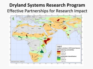
- 7. Criteria for selection of Action Sites Characteristics of potential Action Sites in Target Areas Target Area Potential Potential Potential Action Site 1 Satellite Site 1 Satellite Site 2 Country Geographical location Accessibility Potential for hypothesis testing Representativeness Potential for out- scaling (impact) Potential to attract funds Potential to interact with CRPs
- 8. West Africa & Dry Savannas SRT2: the KKM (Kano-Katsina-Maradi) action transect SRT3: the WBS (Wa-Bobo-Sikasso) action transect Regional: INSAH/CILSS Burkina Faso: INERA Ghana: ARI, CSIR Mali: IER Niger: INRAN Nigeria: ARC
- 9. South Asia Bangladesh: BARI India: ICAR, CRIDA, CAZRI, FES, NRAA, Watershed Organization Trust Pakistan: BARI, CSO, PARC, SSD • Rajasthan (SRT2) • Chakwal, Pakistan as satellite site, mainly SRT2 • Bijapur, Karnataka, India , SRT3 (black soils). • Anantapur & Kurnool, Andhra Pradesh SRT2/3 (red soils) • Maharashtra/ Karnataka Pradesh, satellite SRT3
- 10. Central Asia and Caucasus SRT2: Aral Sea Basin and Rasht Valley SRT3: Fergana Valley Central Asia and Caucasus: Kazakhstan: South- Western Scientific Production Center of Agriculture Tajikistan: TAAS Turkmenistan: National Farmers’ Association, NAS Uzbekistan: Kashkadarya Research Institute
- 11. North Africa and West Asia • SRT2: Jordan/Syria; • SRT2: Satellite: Béni Khedache-Sidi Bouzid, Tunisia • SRT3: Mekness region of Morocco; Egypt Nile delta • SRT3 Satellites: Karkheh River Basin, Iran Egypt: ARC Jordan: NCARE Morocco: INRA Syria: GCSAR, Agha Khan Foundation Tunisia: IRA
- 12. East & Southern Africa SRT2: Northeastern Kenya and Southeastern Ethiopia SRT3: Chinyanja Triangle (central and southern Malawi, eastern province of Zambia, and the Tete Province of Mozambique East and Southern Africa: Ethiopia: EIAR Kenya: KARI South Africa: CSIR, Univ. of Ft Hare, WRC Sudan: ARC Zambia: University of Zambia
- 13. Partner Involvement in Inception Phase Research Prioritization • 16 Common Hypotheses • 20 Common Outputs
- 14. Partnership involvement in Activities (North Africa & West Asia) SRT 2 SRT3
- 15. Partnerships in Systems Research Biological control of the pearl millet head miner • Became serious pest during 1970s in marginal dryland systems of Sahel • Sahel has some of the world’s poorest countries with weak institutions and resource-poor farmers • Over 25 years, multiple funding partners (CILSS, FAO, USAID, McKnight Foundation and BM Gates Foundation) • Over 25 years, multiple research partners (CIRAD, Texas A&M, ICRISAT, IITA, ISRA, IER, INERA) on pest ecology via several uncoordinated short-term projects • Group of prominent national scientists funded by McKnight Foundation developed and deployed a systems-based IPM program • Trained farmers to raise and release parasitic wasp to kill the head miner.
- 16. Better Model for Systems Research and Development • Emphasis on partnership (McKnight Foundation) • National research partners take the lead and gain recognition, leading to uptake and institutional strengthening • Farmers, technicians, students, animateurs, etc. have integrated roles, facilitating adoption • CG centers, “Advanced Research Institutes,” etc. play a supporting partner role • Prominent role for women as scientists, farmers, and beneficiaries
- 17. Outputs, Impact, and Outcome Output: On-farm methodology for mass rearing and release of parasitoid wasp Impact (after 3 years): Release in 385 villages, with an effective coverage approaching more than 200,000 ha. Estimates suggest yield increases of ~40% in the areas of intervention, and that ~72% of larvae akilled. Outcome: National researchers, adequately supported and empowered, deliver real and effective solutions that are: •Scientifically sound •Meet the needs of the smallholder farmers, and •Contribute significantly to improved food security, community resilience, and reduced poverty.
- 18. Outscaling 1. Spillover effects a) Neighboring villages informally seek to learn from animateurs b) Widespread recognition from farmer organizations and local, regional, and national governments (upscaling effects) 2. Good prospects for regional expansion to wherever pearl millet head miner is a production constraint (e.g. from Senegal to Sudan). 3. Because capacity was built at many community levels , the technology can spread based on community involvement without the need for large external financial support.
- 19. Governance with Partners • Steering Committee (DG+3 CG centers+2 ARIs+3 Development Organizations+4 NARS + Director) • Independent Science Advisory Committee (5 members) • Regional Management Committees • Regional Stakeholder Advisory Committees • Regional Science Advisory Committee
Hinweis der Redaktion
- Site Selection When using the criteria laid down across the CRP, namely aridity, length of the growing period, rainfall variability, access to irrigation, land degradation and market access, it became apparent that Maharashtra, Karnataka and Andhra Pradesh in India all have large SRT2 and SRT3 areas, while Rajasthan in India and Pakistan and Afghanistan are mainly SRT2. Based on a higher poverty index, pockets of Rajasthan and Andhra Pradesh are still important for SRT2, and much of Maharashtra and Karnataka for SRT3. Parts of Pakistan in the region of Chakwal have pockets of high poverty for both SRT2 and SRT3.
- Aral Sea and Rasht and Kyzyl-Suu valleys for SRT 2 areas in the CA&C region. The Fergana Valley readily characterizes the SRT 3 areas in the Central Asia & Caucasus region. Climate Precipitation Precipitation varies between the flat alluvial plain areas of the Fergana Valley which receive 150 to 250mm of precipitation per year and the mountains and foothills which receive between 300 and 600mm per year. There are two rainy seasons per year in the spring and autumn. Number of days with precipitations (of 0.1 mm or more): Winter 19-23 Spring 17-19 Summer 5-8 Autumn 10-12 The coefficient of variation (CV) of annual precipitation in the region (n = 50) is 24-35%. Temperature Average annual temperatures range from 7-11°C in the foothills of the eastern part of the valley) and up to 14-15°C in the plains. Average maximum temperatures in July are from 34-35 ° C in the plains and up to 25-30°C in the foothills. The absolute maximum is 43.9°C. Average minimum temperatures in January are from -3° C - 2° C in the flat part and -9° C to -4°C in the foothills. The absolute minimum is – 28.7°C in the plains. Soils In the system of latitude soil-climatic zones, the flat part of the Fergana Valley is a desert area with gray-brown, sandy desert and takyr soils. According to the scheme of the provincial division, the Fergana Valley is included in the Central Asian soil and climatic province, which is characterized by continental climate (dry) and specific subtropical soils differ from soils of the more northern regions of Eurasia. In the irrigated lands in the Valley there are mainly medium loamy soils (43.8%), clay and loamy soils (21.0%), loamy (24.8%), sandy loamy and sandy soils (10.3%), stony gravel and crushed stone on the surface of the soil (0.1%). Land use and cover The main crops in the Fergana Valley are cotton, wheat, vegetables, melons, orchards and vineyards, perennial plants, and other crops. The leading crop is cotton. The area under cotton covers 35-40% of the total area in the Andijan region. Land degradation In Fergana valley salt affected soil is observed as 11.4% of total irrigated area. Great damage to the national economy of the republic is caused by mudslides. Protection of land from wind and water erosions is one of the most pressing issues for further development of agricultural production, protection and improvement of land use. Water resources The main sources of water in the Fergana Valley are: • The River Karadarya - mixed filling • The Naryn river - mixed filling • The Maylisay and Tentaksay - snow filling • The Syrdarya River According to the annual report of Narin-Kara-Dayra and Sokh-Syrdara River Basin Authority 95 to 96% of water, on low water years, is used for irrigation. In the Fergana Valley, the quality of irrigation water meets water quality requirements for irrigation. Salinity of water in the rivers and small streams is low. In the flood period in April and May), the silt content in rivers and small streams increases to a noticeable level especially in the foothill areas. Downstream silt content increases due to wastewater and channel deformations. At the south part of the Andijan region (Booz, Ulugnar, Balykchy), collected drainage water is used for irrigation as its salinity is low and it meets the requirements for irrigation. Farming systems In the mountains of Fergana Valley, the following crops are grown: natural feeds, almonds, walnuts and wild rose. In the foothills wheat, barley, alfalfa, sainfoin, horticultures, large fruits and potato are grown. On the plains wheat, cotton, tobacco, maize, potato, onion, carrot, beans, vegetables, melons, fruit and berry crops, alfalfa and greenhouse crops are grown. Livestock is an important part of the Fergana Valley’s agriculture, contributing to the insuring of the population with food and industries by the raw materials. Depending on the natural-climatic conditions of the region, livestock can be divided into intensive (industrial), extensive (grazing), and domestic. Dairy cattle breeding, poultry farming is concentrated in the suburban area of irrigation. Pasture livestock is concentrated in the area with the lowest natural resource potential on private lands. Depending on the natural-climatic conditions of the region it can be divided into intensive (industrial), extensive (grazing), and domestic livestock. Dairy cattle breeding and poultry farming is concentrated in the suburban irrigated area. Institutional Support and Policies The Institute "Uzdaverloyiha" together with the research and project organizations of the republic developed a "scheme of erosion control measures in the Republic of Uzbekistan", which defines the series of measures on erosion control, and their scale and sequence of operations.
- The two benchmark areas include south Jordan, Syria, south Turkey, and west and north Iraq for SRT2, and the high rainfall areas (>500 mm) of the northern parts of the Morocco, Algeria and Tunisia for SRT3.
- Strongest academic role for Mme Dabire, who also has national and international status