
Empfohlen
Weitere ähnliche Inhalte
Andere mochten auch
Andere mochten auch (14)
Mehr von esandrag
Mehr von esandrag (11)
Kürzlich hochgeladen
Kürzlich hochgeladen (20)
Project on Google Earth in Biology and Geology
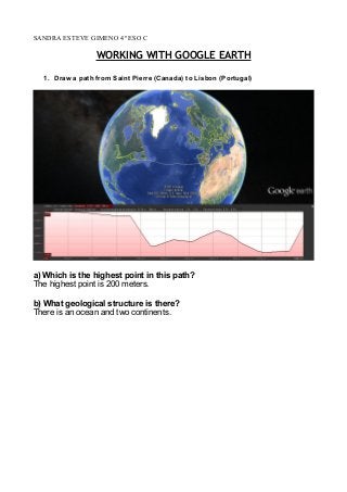
- 1. SANDRA ESTEVE GIMENO 4º ESO C WORKING WITH GOOGLE EARTH 1. Draw a path from Saint Pierre (Canada) to Lisbon (Portugal) a) Which is the highest point in this path? The highest point is 200 meters. b) What geological structure is there? There is an ocean and two continents.
- 2. 2. Draw a new path from Greenland to Ireland a) Which is the highest point now? The highest point is 1348 meters. b) What geological structure is there? An ocean, two continents and an island.
- 3. 3. Go now to the Pacific ocean and find Mariana Islands. Draw a path crossing perpendicularly the row of islands. a) Which is the lowest point? The lowest point is -95 meters b) What geological structure do you find there? I find three mountains underwater that convert into islands and an ocean.
- 4. LANDFORMS → COASTAL LANDFORM Coastal landforms are made by the wearing away of land and the removal of beach or dune sediments by wave action, tidal currents, wave currents or drainage. Waves, generated by storms, wind, or fast moving motor craft, cause coastal erosion, which may take the form of long-term losses of sediment and rocks, or merely the temporary redistribution of coastal sediments; erosion in one location may result in accretion nearby. It may be caused by hydraulic action, abrasion, impact and corrosion.
- 5. → GLACIAL LANDFORM The glacial erosional features are associated with alpine glaciation. Rugged mountainous areas are made by glacial action. Alpine glaciers transform V‐ shaped valleys made by streams into deeper U‐shaped valleys called glacial troughs—the ice is too massive to follow the stream bed and pushes right through, scouring out a U shape. The ice also erodes away the ends of any ridges along the valley walls. These eroded ridges are called truncated spurs. The valleys of tributaries can also be truncated, forming hanging valleys that are higher than the main valley and often marked by waterfalls. The mass of ice at the top of a glacial valley forms a steep‐sided, circular hollow called a cirque. Mass wasting and frost wedging also contribute to the formation of a cirque. A bergschrund is a crevasse that forms where the glacier separates from the cirque wall and is commonly filled with rock fall debris. A horn is a sharply defined peak that has formed from erosional processes. A steep ridge called an arete extends downward from a horn to separate two adjacent glacial valleys. An advancing glacier scours out a series of depressions.
- 6. → RIVER LANDFORM Rivers are constanlty modifying their channel and surrounding landscape. As a result of the potential energy (derived from the gravitional force) as well as its kinetic energy (derived from it movement downslope) the river cuts vertically into channel. This creates a deepened channel as a result of hydraulic action and abrasion; solution may also be present if the river cuts down to the bedrock layer. If this process acted in isolation the channel would take on a very acute, steep v-shape form. However, due to surface run-off, soil creep and other mass movements the valley sides become more gentle. Weathering processes may also aid this breaking down of the valley side. Rivers will always choose to take the most efficient route downslope. If the river flow encounters an obstacle of resistence, it will change direction and flow around that obstacle. In doing so, it preserves energy and takes the most efficient route. These changes in direction are the birth of hillside spurs. As the river cuts deeper, its valley becomes more pronounced and recognisable. It is normal for a river to make subtle changes in direction repeatedly in its flow downslope; in doing so, interlocking spurs form.
- 7. → MOUNTAIN LANDFORM A landform is a feature on the Earth's surface that is part of the terrain. Mountains, hills, plateaus, and plains are the four major types of landforms. Minor landforms include buttes, canyons, valleys, and basins. Tectonic plate movement under the Earth can create landforms by pushing up mountains and hills. Erosion by water and wind can wear down land and create landforms like valleys and canyons. Both processes happen over a long period of time, sometimes millions of years. Landforms can exist under water in the form of mountain ranges and basins under the sea. The Mariana Trench, the deepest landform on Earth, is in the South Pacific Ocean.