SlideShare ist ein Scribd-Unternehmen logo
1 von 13
Downloaden Sie, um offline zu lesen
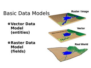
Basic Data Models

  Vector Data
  Model
  (entities)

  Raster Data
  Model
  (fields)
Raster Data Models
  Establishes a pattern of similar grids
  or cells over a geographic area
  The location of each cell is defined by
  its row and column indices
  The value assigned to a cell either
  reflects    the    dominant     feature
  (attribute) at that grid space or
  indicates the presence of a preferred
  feature in case where two or more
  features are present within a single
  grid space
Raster Data Models
  Basic unit in a raster is a cell (or grid
  or pixel)
  Analytically more powerful than the
  vector based GIS
Raster Data Model
3


     5
10
               +               2


                         4
                                                5
                    10             =
                                            9
                                       20
     Direct calculations using raster layers
Comparison between raster and vector
                     Raster    Vector
 Data collection      Rapid     Slow
 Data volume          Large     Small
 Graphic treatment   Average    Good
 Data structure      Simple    Complex
 Geometrical          Low       High
 accuracy
 Analysis in          Poor      Good
 network
 Area analysis        Good     Average
 Generalization      Simple    Complex
Attribute Data
Raster data formats
                             (http://www.gdal.org/formats_list.html)
Arc/Info ASCII Grid , Arc/Info Binary Grid (.adf) , AIRSAR Polarimetric ,
  Microsoft Windows Device Independent Bitmap (.bmp) , BSB Nautical Chart
  Format (.kap) , VTP Binary Terrain Format (.bt) , CEOS (Spot for instance),
  First Generation USGS DOQ (.doq) , DODS / OPeNDAP , New Labelled USGS
  DOQ (.doq) , Military Elevation Data (.dt0, .dt1) , ERMapper Compressed
  Wavelets (.ecw) , ESRI .hdr Labelled , ENVI .hdr Labelled Raster ,
  Envisat Image Product (.n1) , EOSAT FAST Format , FITS (.fits) , Graphics
  Interchange Format (.gif) , Arc/Info Binary Grid (.adf) , GRASS Rasters ,
  TIFF / GeoTIFF (.tif) , Hierarchical Data Format Release 4 (HDF4) ,
  Erdas Imagine (.img) , Atlantis MFF2e , Image Display and Analysis
  (WinDisp) , ILWIS Raster Map (.mpr,.mpl) , Japanese DEM (.mem) , JPEG JFIF
  (.jpg) , JPEG2000 (.jp2, .j2k) , JPEG2000 (.jp2, .j2k) , JPEG2000 (.jp2,
  .j2k) , NOAA Polar Orbiter Level 1b Data Set (AVHRR) , Erdas 7.x .LAN
  and .GIS , In Memory Raster , Atlantis MFF , Multi-resolution Seamless Image
  Database , Meteosat Second Generation , NDF , NITF , NetCDF , OGDI Bridge
  , PCI .aux Labelled , PCI Geomatics Database File , Portable Network
  Graphics (.png) , PCRaster (.map) , Netpbm (.ppm,.pgm) , RadarSat2 XML
  (product.xml) , USGS SDTS DEM (*CATD.DDF) , Raster Matrix Format (*.rsw, .mtw)
  , SAR CEOS , USGS ASCII DEM (.dem) , X11 Pixmap (.xpm)
Creating digital datasets
    by manual input
Georeferencing
●   all spatial data in a common frame of
    reference
●   common coordinate system is plane,
    orthogonal cartesian coordinates
●   referenced with ground and field surveys
    or GPS
●   In GRASS
    –   i.group, i.target, i.points, i.rectify
Northing


           Conformal
           transformation
           X =c 1 ax− by
           Y =c 2 ayby
                            Easting
Raster

Weitere ähnliche Inhalte

Was ist angesagt?

Geographic Information System unit 1
Geographic Information System   unit 1Geographic Information System   unit 1
Geographic Information System unit 1sridevi5983
 
Gis (geographic information system)
Gis (geographic information system)Gis (geographic information system)
Gis (geographic information system)Saad Bare
 
Introduction to GIS
Introduction to GISIntroduction to GIS
Introduction to GISJoey Li
 
Digital Elevation Models
Digital Elevation ModelsDigital Elevation Models
Digital Elevation ModelsBernd Flmla
 
Data base management system
Data base management systemData base management system
Data base management systemPramoda Raj
 
GIS and QGIS training notes
GIS and QGIS training notesGIS and QGIS training notes
GIS and QGIS training notesArnold Kilaini
 
Arc gis introduction-ppt
Arc gis introduction-pptArc gis introduction-ppt
Arc gis introduction-pptAshok Peddi
 
Principles of GIS unit 1
Principles of GIS unit 1Principles of GIS unit 1
Principles of GIS unit 1SanjanaKhemka1
 
TYBSC IT PGIS Unit I Chapter I- Introduction to Geographic Information Systems
TYBSC IT PGIS Unit I  Chapter I- Introduction to Geographic Information SystemsTYBSC IT PGIS Unit I  Chapter I- Introduction to Geographic Information Systems
TYBSC IT PGIS Unit I Chapter I- Introduction to Geographic Information SystemsArti Parab Academics
 
TYBSC IT PGIS Unit III Chapter II Data Entry and Preparation
TYBSC IT PGIS Unit III Chapter II Data Entry and PreparationTYBSC IT PGIS Unit III Chapter II Data Entry and Preparation
TYBSC IT PGIS Unit III Chapter II Data Entry and PreparationArti Parab Academics
 

Was ist angesagt? (20)

Geographic Information System unit 1
Geographic Information System   unit 1Geographic Information System   unit 1
Geographic Information System unit 1
 
Introduction to GIS
Introduction to GISIntroduction to GIS
Introduction to GIS
 
Four data models in GIS
Four data models in GISFour data models in GIS
Four data models in GIS
 
Gis (geographic information system)
Gis (geographic information system)Gis (geographic information system)
Gis (geographic information system)
 
GIS data analysis
GIS data analysisGIS data analysis
GIS data analysis
 
Introduction to GIS
Introduction to GISIntroduction to GIS
Introduction to GIS
 
GIS
GISGIS
GIS
 
Digital Elevation Models
Digital Elevation ModelsDigital Elevation Models
Digital Elevation Models
 
Spatial Database Systems
Spatial Database SystemsSpatial Database Systems
Spatial Database Systems
 
Data base management system
Data base management systemData base management system
Data base management system
 
Introduction to gis
Introduction to gisIntroduction to gis
Introduction to gis
 
GIS and QGIS training notes
GIS and QGIS training notesGIS and QGIS training notes
GIS and QGIS training notes
 
Arc gis introduction-ppt
Arc gis introduction-pptArc gis introduction-ppt
Arc gis introduction-ppt
 
Fundamentals of GIS
Fundamentals of GISFundamentals of GIS
Fundamentals of GIS
 
Principles of GIS unit 1
Principles of GIS unit 1Principles of GIS unit 1
Principles of GIS unit 1
 
GIS Map Projection
GIS Map ProjectionGIS Map Projection
GIS Map Projection
 
Introduction to GIS
Introduction to GISIntroduction to GIS
Introduction to GIS
 
TYBSC IT PGIS Unit I Chapter I- Introduction to Geographic Information Systems
TYBSC IT PGIS Unit I  Chapter I- Introduction to Geographic Information SystemsTYBSC IT PGIS Unit I  Chapter I- Introduction to Geographic Information Systems
TYBSC IT PGIS Unit I Chapter I- Introduction to Geographic Information Systems
 
Spatial databases
Spatial databasesSpatial databases
Spatial databases
 
TYBSC IT PGIS Unit III Chapter II Data Entry and Preparation
TYBSC IT PGIS Unit III Chapter II Data Entry and PreparationTYBSC IT PGIS Unit III Chapter II Data Entry and Preparation
TYBSC IT PGIS Unit III Chapter II Data Entry and Preparation
 

Andere mochten auch

Data models in geographical information system(GIS)
Data models in geographical information system(GIS)Data models in geographical information system(GIS)
Data models in geographical information system(GIS)Pramoda Raj
 
Raster and vector
Raster and vectorRaster and vector
Raster and vectorleeanne123
 
Vector graphics and raster graphics
Vector graphics and raster graphicsVector graphics and raster graphics
Vector graphics and raster graphicsstephlizahawkins123
 
Raster Vs. Vector Presentation1
Raster Vs. Vector Presentation1Raster Vs. Vector Presentation1
Raster Vs. Vector Presentation1cdoeberl
 
Vectors
VectorsVectors
Vectorseliseb
 
Vector & raster graphic
Vector & raster graphicVector & raster graphic
Vector & raster graphicKhang-Ling Loh
 
Topology presentation
Topology  presentationTopology  presentation
Topology presentationJobaida Nahar
 
Introduction to Vectors
Introduction to VectorsIntroduction to Vectors
Introduction to VectorsM.T.H Group
 
Spatial vs non spatial
Spatial vs non spatialSpatial vs non spatial
Spatial vs non spatialSumant Diwakar
 
Chemical bonding
Chemical bondingChemical bonding
Chemical bondingPramoda Raj
 
raster data model
raster data modelraster data model
raster data modelRiya Gupta
 
Tours les jours2
Tours les jours2Tours les jours2
Tours les jours2chanpinqi
 
Rastar Capabilities
Rastar CapabilitiesRastar Capabilities
Rastar Capabilitiesbsattree
 

Andere mochten auch (20)

Topology in GIS
Topology in GISTopology in GIS
Topology in GIS
 
Vectors and Rasters
Vectors and RastersVectors and Rasters
Vectors and Rasters
 
GIS Data Types
GIS Data TypesGIS Data Types
GIS Data Types
 
Data models in geographical information system(GIS)
Data models in geographical information system(GIS)Data models in geographical information system(GIS)
Data models in geographical information system(GIS)
 
Raster and vector
Raster and vectorRaster and vector
Raster and vector
 
Vector graphics and raster graphics
Vector graphics and raster graphicsVector graphics and raster graphics
Vector graphics and raster graphics
 
Raster Vs. Vector Presentation1
Raster Vs. Vector Presentation1Raster Vs. Vector Presentation1
Raster Vs. Vector Presentation1
 
Vectors
VectorsVectors
Vectors
 
Vector & raster graphic
Vector & raster graphicVector & raster graphic
Vector & raster graphic
 
Topology presentation
Topology  presentationTopology  presentation
Topology presentation
 
Introduction to Vectors
Introduction to VectorsIntroduction to Vectors
Introduction to Vectors
 
Spatial vs non spatial
Spatial vs non spatialSpatial vs non spatial
Spatial vs non spatial
 
Vectors
VectorsVectors
Vectors
 
Vectors
Vectors Vectors
Vectors
 
Chemical bonding
Chemical bondingChemical bonding
Chemical bonding
 
raster data model
raster data modelraster data model
raster data model
 
Bb geodatabase
Bb geodatabaseBb geodatabase
Bb geodatabase
 
Tours les jours2
Tours les jours2Tours les jours2
Tours les jours2
 
Rastar Capabilities
Rastar CapabilitiesRastar Capabilities
Rastar Capabilities
 
Spatial Data Model
Spatial Data ModelSpatial Data Model
Spatial Data Model
 

Ähnlich wie Raster

Conceptual models of real world geographical phenomena (epm107_2007)
Conceptual models of real world geographical phenomena (epm107_2007)Conceptual models of real world geographical phenomena (epm107_2007)
Conceptual models of real world geographical phenomena (epm107_2007)esambale
 
Raster data model
Raster data modelRaster data model
Raster data modelPramoda Raj
 
Raster data model
Raster data modelRaster data model
Raster data modelPramoda Raj
 
Scattered gis handbook
Scattered gis handbookScattered gis handbook
Scattered gis handbookWaleed Liaqat
 
FME Lightning Talk: Raster
FME Lightning Talk: RasterFME Lightning Talk: Raster
FME Lightning Talk: RasterSafe Software
 
FME 2012 World Tour - Lightning Talk on Rasters
FME 2012 World Tour - Lightning Talk on RastersFME 2012 World Tour - Lightning Talk on Rasters
FME 2012 World Tour - Lightning Talk on RastersIMGS
 
Practical data science_public
Practical data science_publicPractical data science_public
Practical data science_publicLong Nguyen
 
Stockage, manipulation et analyse de données matricielles avec PostGIS Raster
Stockage, manipulation et analyse de données matricielles avec PostGIS RasterStockage, manipulation et analyse de données matricielles avec PostGIS Raster
Stockage, manipulation et analyse de données matricielles avec PostGIS RasterACSG Section Montréal
 
Lect 5 data models-gis
Lect 5 data models-gisLect 5 data models-gis
Lect 5 data models-gisRehana Jamal
 
introduction to geographical information system
introduction to geographical information systemintroduction to geographical information system
introduction to geographical information systemDrVenkateswarluGogan1
 
UG6thSem_major_GIS Data Structures.pptx DR P DAS.1.pptx
UG6thSem_major_GIS Data Structures.pptx DR P DAS.1.pptxUG6thSem_major_GIS Data Structures.pptx DR P DAS.1.pptx
UG6thSem_major_GIS Data Structures.pptx DR P DAS.1.pptxNancyVerma72
 
Modelo de dados vetorial e matricial - slides
Modelo de dados vetorial e matricial - slidesModelo de dados vetorial e matricial - slides
Modelo de dados vetorial e matricial - slidesLuzianeRibeiroIndjai
 
Vector and Raster Data data model
Vector and Raster Data data modelVector and Raster Data data model
Vector and Raster Data data modelCalcutta University
 
GIS and Mapping Software Introduction
GIS and Mapping Software IntroductionGIS and Mapping Software Introduction
GIS and Mapping Software IntroductionMEASURE Evaluation
 
33286 gis%20 lecture%20six-1
33286 gis%20 lecture%20six-133286 gis%20 lecture%20six-1
33286 gis%20 lecture%20six-1Hisham Ibnuqaiyim
 
spatial databases ADBMS ppt
spatial databases ADBMS pptspatial databases ADBMS ppt
spatial databases ADBMS pptRitaThakkar1
 

Ähnlich wie Raster (20)

Conceptual models of real world geographical phenomena (epm107_2007)
Conceptual models of real world geographical phenomena (epm107_2007)Conceptual models of real world geographical phenomena (epm107_2007)
Conceptual models of real world geographical phenomena (epm107_2007)
 
Gis Concepts 2/5
Gis Concepts 2/5Gis Concepts 2/5
Gis Concepts 2/5
 
Raster data model
Raster data modelRaster data model
Raster data model
 
Raster data model
Raster data modelRaster data model
Raster data model
 
GIS & Raster
GIS & RasterGIS & Raster
GIS & Raster
 
Scattered gis handbook
Scattered gis handbookScattered gis handbook
Scattered gis handbook
 
FME Lightning Talk: Raster
FME Lightning Talk: RasterFME Lightning Talk: Raster
FME Lightning Talk: Raster
 
FME 2012 World Tour - Lightning Talk on Rasters
FME 2012 World Tour - Lightning Talk on RastersFME 2012 World Tour - Lightning Talk on Rasters
FME 2012 World Tour - Lightning Talk on Rasters
 
Practical data science_public
Practical data science_publicPractical data science_public
Practical data science_public
 
Understanding raster
Understanding rasterUnderstanding raster
Understanding raster
 
Stockage, manipulation et analyse de données matricielles avec PostGIS Raster
Stockage, manipulation et analyse de données matricielles avec PostGIS RasterStockage, manipulation et analyse de données matricielles avec PostGIS Raster
Stockage, manipulation et analyse de données matricielles avec PostGIS Raster
 
Lect 5 data models-gis
Lect 5 data models-gisLect 5 data models-gis
Lect 5 data models-gis
 
Geographical Information System (GIS)
Geographical Information System (GIS)Geographical Information System (GIS)
Geographical Information System (GIS)
 
introduction to geographical information system
introduction to geographical information systemintroduction to geographical information system
introduction to geographical information system
 
UG6thSem_major_GIS Data Structures.pptx DR P DAS.1.pptx
UG6thSem_major_GIS Data Structures.pptx DR P DAS.1.pptxUG6thSem_major_GIS Data Structures.pptx DR P DAS.1.pptx
UG6thSem_major_GIS Data Structures.pptx DR P DAS.1.pptx
 
Modelo de dados vetorial e matricial - slides
Modelo de dados vetorial e matricial - slidesModelo de dados vetorial e matricial - slides
Modelo de dados vetorial e matricial - slides
 
Vector and Raster Data data model
Vector and Raster Data data modelVector and Raster Data data model
Vector and Raster Data data model
 
GIS and Mapping Software Introduction
GIS and Mapping Software IntroductionGIS and Mapping Software Introduction
GIS and Mapping Software Introduction
 
33286 gis%20 lecture%20six-1
33286 gis%20 lecture%20six-133286 gis%20 lecture%20six-1
33286 gis%20 lecture%20six-1
 
spatial databases ADBMS ppt
spatial databases ADBMS pptspatial databases ADBMS ppt
spatial databases ADBMS ppt
 

Mehr von esambale

Open data initiatives
Open data initiativesOpen data initiatives
Open data initiativesesambale
 
Contributing to OpenStreetMap (OSMPH)
Contributing to OpenStreetMap (OSMPH)Contributing to OpenStreetMap (OSMPH)
Contributing to OpenStreetMap (OSMPH)esambale
 
About osmph
About osmphAbout osmph
About osmphesambale
 
Map design
Map designMap design
Map designesambale
 
Geoladies 20140609
Geoladies 20140609Geoladies 20140609
Geoladies 20140609esambale
 
DepEd's Schools Mapping Initiative
DepEd's Schools Mapping InitiativeDepEd's Schools Mapping Initiative
DepEd's Schools Mapping Initiativeesambale
 
State of OpenStreetMap Indonesia
State of OpenStreetMap IndonesiaState of OpenStreetMap Indonesia
State of OpenStreetMap Indonesiaesambale
 
Using OSM, QGIS, and InaSAFE for Contingency Plan in Indonesia
Using OSM, QGIS, and InaSAFE for Contingency Plan in Indonesia Using OSM, QGIS, and InaSAFE for Contingency Plan in Indonesia
Using OSM, QGIS, and InaSAFE for Contingency Plan in Indonesia esambale
 
Participatory mapping and LGU decision support tools for Disaster Risk Reduct...
Participatory mapping and LGU decision support tools for Disaster Risk Reduct...Participatory mapping and LGU decision support tools for Disaster Risk Reduct...
Participatory mapping and LGU decision support tools for Disaster Risk Reduct...esambale
 
InaSAFE Development in the Philippines
InaSAFE Development in the Philippines InaSAFE Development in the Philippines
InaSAFE Development in the Philippines esambale
 
Maperitive
MaperitiveMaperitive
Maperitiveesambale
 
OpenStreetMap QA tools
OpenStreetMap QA toolsOpenStreetMap QA tools
OpenStreetMap QA toolsesambale
 
My GPS Stories
My GPS StoriesMy GPS Stories
My GPS Storiesesambale
 
OSM-Philippines and the Yolanda Crisis Mapping Response
OSM-Philippines and the Yolanda Crisis Mapping ResponseOSM-Philippines and the Yolanda Crisis Mapping Response
OSM-Philippines and the Yolanda Crisis Mapping Responseesambale
 
Free GEO Culture and OpenStreetMap
Free GEO Culture and OpenStreetMapFree GEO Culture and OpenStreetMap
Free GEO Culture and OpenStreetMapesambale
 
ESSC OSM-PH WB project
ESSC OSM-PH WB projectESSC OSM-PH WB project
ESSC OSM-PH WB projectesambale
 
Philippine Geospatial Forum Presentation 20130311
Philippine Geospatial Forum Presentation 20130311Philippine Geospatial Forum Presentation 20130311
Philippine Geospatial Forum Presentation 20130311esambale
 
OSM SFD2012
OSM SFD2012OSM SFD2012
OSM SFD2012esambale
 
FOSS4G 2011 Osaka
FOSS4G 2011 OsakaFOSS4G 2011 Osaka
FOSS4G 2011 Osakaesambale
 
foss4g 2011 tokyo
foss4g 2011 tokyofoss4g 2011 tokyo
foss4g 2011 tokyoesambale
 

Mehr von esambale (20)

Open data initiatives
Open data initiativesOpen data initiatives
Open data initiatives
 
Contributing to OpenStreetMap (OSMPH)
Contributing to OpenStreetMap (OSMPH)Contributing to OpenStreetMap (OSMPH)
Contributing to OpenStreetMap (OSMPH)
 
About osmph
About osmphAbout osmph
About osmph
 
Map design
Map designMap design
Map design
 
Geoladies 20140609
Geoladies 20140609Geoladies 20140609
Geoladies 20140609
 
DepEd's Schools Mapping Initiative
DepEd's Schools Mapping InitiativeDepEd's Schools Mapping Initiative
DepEd's Schools Mapping Initiative
 
State of OpenStreetMap Indonesia
State of OpenStreetMap IndonesiaState of OpenStreetMap Indonesia
State of OpenStreetMap Indonesia
 
Using OSM, QGIS, and InaSAFE for Contingency Plan in Indonesia
Using OSM, QGIS, and InaSAFE for Contingency Plan in Indonesia Using OSM, QGIS, and InaSAFE for Contingency Plan in Indonesia
Using OSM, QGIS, and InaSAFE for Contingency Plan in Indonesia
 
Participatory mapping and LGU decision support tools for Disaster Risk Reduct...
Participatory mapping and LGU decision support tools for Disaster Risk Reduct...Participatory mapping and LGU decision support tools for Disaster Risk Reduct...
Participatory mapping and LGU decision support tools for Disaster Risk Reduct...
 
InaSAFE Development in the Philippines
InaSAFE Development in the Philippines InaSAFE Development in the Philippines
InaSAFE Development in the Philippines
 
Maperitive
MaperitiveMaperitive
Maperitive
 
OpenStreetMap QA tools
OpenStreetMap QA toolsOpenStreetMap QA tools
OpenStreetMap QA tools
 
My GPS Stories
My GPS StoriesMy GPS Stories
My GPS Stories
 
OSM-Philippines and the Yolanda Crisis Mapping Response
OSM-Philippines and the Yolanda Crisis Mapping ResponseOSM-Philippines and the Yolanda Crisis Mapping Response
OSM-Philippines and the Yolanda Crisis Mapping Response
 
Free GEO Culture and OpenStreetMap
Free GEO Culture and OpenStreetMapFree GEO Culture and OpenStreetMap
Free GEO Culture and OpenStreetMap
 
ESSC OSM-PH WB project
ESSC OSM-PH WB projectESSC OSM-PH WB project
ESSC OSM-PH WB project
 
Philippine Geospatial Forum Presentation 20130311
Philippine Geospatial Forum Presentation 20130311Philippine Geospatial Forum Presentation 20130311
Philippine Geospatial Forum Presentation 20130311
 
OSM SFD2012
OSM SFD2012OSM SFD2012
OSM SFD2012
 
FOSS4G 2011 Osaka
FOSS4G 2011 OsakaFOSS4G 2011 Osaka
FOSS4G 2011 Osaka
 
foss4g 2011 tokyo
foss4g 2011 tokyofoss4g 2011 tokyo
foss4g 2011 tokyo
 

Kürzlich hochgeladen

unit 4 immunoblotting technique complete.pptx
unit 4 immunoblotting technique complete.pptxunit 4 immunoblotting technique complete.pptx
unit 4 immunoblotting technique complete.pptxBkGupta21
 
The State of Passkeys with FIDO Alliance.pptx
The State of Passkeys with FIDO Alliance.pptxThe State of Passkeys with FIDO Alliance.pptx
The State of Passkeys with FIDO Alliance.pptxLoriGlavin3
 
The Fit for Passkeys for Employee and Consumer Sign-ins: FIDO Paris Seminar.pptx
The Fit for Passkeys for Employee and Consumer Sign-ins: FIDO Paris Seminar.pptxThe Fit for Passkeys for Employee and Consumer Sign-ins: FIDO Paris Seminar.pptx
The Fit for Passkeys for Employee and Consumer Sign-ins: FIDO Paris Seminar.pptxLoriGlavin3
 
TeamStation AI System Report LATAM IT Salaries 2024
TeamStation AI System Report LATAM IT Salaries 2024TeamStation AI System Report LATAM IT Salaries 2024
TeamStation AI System Report LATAM IT Salaries 2024Lonnie McRorey
 
DSPy a system for AI to Write Prompts and Do Fine Tuning
DSPy a system for AI to Write Prompts and Do Fine TuningDSPy a system for AI to Write Prompts and Do Fine Tuning
DSPy a system for AI to Write Prompts and Do Fine TuningLars Bell
 
Advanced Computer Architecture – An Introduction
Advanced Computer Architecture – An IntroductionAdvanced Computer Architecture – An Introduction
Advanced Computer Architecture – An IntroductionDilum Bandara
 
From Family Reminiscence to Scholarly Archive .
From Family Reminiscence to Scholarly Archive .From Family Reminiscence to Scholarly Archive .
From Family Reminiscence to Scholarly Archive .Alan Dix
 
New from BookNet Canada for 2024: Loan Stars - Tech Forum 2024
New from BookNet Canada for 2024: Loan Stars - Tech Forum 2024New from BookNet Canada for 2024: Loan Stars - Tech Forum 2024
New from BookNet Canada for 2024: Loan Stars - Tech Forum 2024BookNet Canada
 
Transcript: New from BookNet Canada for 2024: Loan Stars - Tech Forum 2024
Transcript: New from BookNet Canada for 2024: Loan Stars - Tech Forum 2024Transcript: New from BookNet Canada for 2024: Loan Stars - Tech Forum 2024
Transcript: New from BookNet Canada for 2024: Loan Stars - Tech Forum 2024BookNet Canada
 
"Debugging python applications inside k8s environment", Andrii Soldatenko
"Debugging python applications inside k8s environment", Andrii Soldatenko"Debugging python applications inside k8s environment", Andrii Soldatenko
"Debugging python applications inside k8s environment", Andrii SoldatenkoFwdays
 
How AI, OpenAI, and ChatGPT impact business and software.
How AI, OpenAI, and ChatGPT impact business and software.How AI, OpenAI, and ChatGPT impact business and software.
How AI, OpenAI, and ChatGPT impact business and software.Curtis Poe
 
Dev Dives: Streamline document processing with UiPath Studio Web
Dev Dives: Streamline document processing with UiPath Studio WebDev Dives: Streamline document processing with UiPath Studio Web
Dev Dives: Streamline document processing with UiPath Studio WebUiPathCommunity
 
The Role of FIDO in a Cyber Secure Netherlands: FIDO Paris Seminar.pptx
The Role of FIDO in a Cyber Secure Netherlands: FIDO Paris Seminar.pptxThe Role of FIDO in a Cyber Secure Netherlands: FIDO Paris Seminar.pptx
The Role of FIDO in a Cyber Secure Netherlands: FIDO Paris Seminar.pptxLoriGlavin3
 
Sample pptx for embedding into website for demo
Sample pptx for embedding into website for demoSample pptx for embedding into website for demo
Sample pptx for embedding into website for demoHarshalMandlekar2
 
Transcript: New from BookNet Canada for 2024: BNC CataList - Tech Forum 2024
Transcript: New from BookNet Canada for 2024: BNC CataList - Tech Forum 2024Transcript: New from BookNet Canada for 2024: BNC CataList - Tech Forum 2024
Transcript: New from BookNet Canada for 2024: BNC CataList - Tech Forum 2024BookNet Canada
 
A Deep Dive on Passkeys: FIDO Paris Seminar.pptx
A Deep Dive on Passkeys: FIDO Paris Seminar.pptxA Deep Dive on Passkeys: FIDO Paris Seminar.pptx
A Deep Dive on Passkeys: FIDO Paris Seminar.pptxLoriGlavin3
 
A Journey Into the Emotions of Software Developers
A Journey Into the Emotions of Software DevelopersA Journey Into the Emotions of Software Developers
A Journey Into the Emotions of Software DevelopersNicole Novielli
 
The Ultimate Guide to Choosing WordPress Pros and Cons
The Ultimate Guide to Choosing WordPress Pros and ConsThe Ultimate Guide to Choosing WordPress Pros and Cons
The Ultimate Guide to Choosing WordPress Pros and ConsPixlogix Infotech
 
SIP trunking in Janus @ Kamailio World 2024
SIP trunking in Janus @ Kamailio World 2024SIP trunking in Janus @ Kamailio World 2024
SIP trunking in Janus @ Kamailio World 2024Lorenzo Miniero
 
Take control of your SAP testing with UiPath Test Suite
Take control of your SAP testing with UiPath Test SuiteTake control of your SAP testing with UiPath Test Suite
Take control of your SAP testing with UiPath Test SuiteDianaGray10
 

Kürzlich hochgeladen (20)

unit 4 immunoblotting technique complete.pptx
unit 4 immunoblotting technique complete.pptxunit 4 immunoblotting technique complete.pptx
unit 4 immunoblotting technique complete.pptx
 
The State of Passkeys with FIDO Alliance.pptx
The State of Passkeys with FIDO Alliance.pptxThe State of Passkeys with FIDO Alliance.pptx
The State of Passkeys with FIDO Alliance.pptx
 
The Fit for Passkeys for Employee and Consumer Sign-ins: FIDO Paris Seminar.pptx
The Fit for Passkeys for Employee and Consumer Sign-ins: FIDO Paris Seminar.pptxThe Fit for Passkeys for Employee and Consumer Sign-ins: FIDO Paris Seminar.pptx
The Fit for Passkeys for Employee and Consumer Sign-ins: FIDO Paris Seminar.pptx
 
TeamStation AI System Report LATAM IT Salaries 2024
TeamStation AI System Report LATAM IT Salaries 2024TeamStation AI System Report LATAM IT Salaries 2024
TeamStation AI System Report LATAM IT Salaries 2024
 
DSPy a system for AI to Write Prompts and Do Fine Tuning
DSPy a system for AI to Write Prompts and Do Fine TuningDSPy a system for AI to Write Prompts and Do Fine Tuning
DSPy a system for AI to Write Prompts and Do Fine Tuning
 
Advanced Computer Architecture – An Introduction
Advanced Computer Architecture – An IntroductionAdvanced Computer Architecture – An Introduction
Advanced Computer Architecture – An Introduction
 
From Family Reminiscence to Scholarly Archive .
From Family Reminiscence to Scholarly Archive .From Family Reminiscence to Scholarly Archive .
From Family Reminiscence to Scholarly Archive .
 
New from BookNet Canada for 2024: Loan Stars - Tech Forum 2024
New from BookNet Canada for 2024: Loan Stars - Tech Forum 2024New from BookNet Canada for 2024: Loan Stars - Tech Forum 2024
New from BookNet Canada for 2024: Loan Stars - Tech Forum 2024
 
Transcript: New from BookNet Canada for 2024: Loan Stars - Tech Forum 2024
Transcript: New from BookNet Canada for 2024: Loan Stars - Tech Forum 2024Transcript: New from BookNet Canada for 2024: Loan Stars - Tech Forum 2024
Transcript: New from BookNet Canada for 2024: Loan Stars - Tech Forum 2024
 
"Debugging python applications inside k8s environment", Andrii Soldatenko
"Debugging python applications inside k8s environment", Andrii Soldatenko"Debugging python applications inside k8s environment", Andrii Soldatenko
"Debugging python applications inside k8s environment", Andrii Soldatenko
 
How AI, OpenAI, and ChatGPT impact business and software.
How AI, OpenAI, and ChatGPT impact business and software.How AI, OpenAI, and ChatGPT impact business and software.
How AI, OpenAI, and ChatGPT impact business and software.
 
Dev Dives: Streamline document processing with UiPath Studio Web
Dev Dives: Streamline document processing with UiPath Studio WebDev Dives: Streamline document processing with UiPath Studio Web
Dev Dives: Streamline document processing with UiPath Studio Web
 
The Role of FIDO in a Cyber Secure Netherlands: FIDO Paris Seminar.pptx
The Role of FIDO in a Cyber Secure Netherlands: FIDO Paris Seminar.pptxThe Role of FIDO in a Cyber Secure Netherlands: FIDO Paris Seminar.pptx
The Role of FIDO in a Cyber Secure Netherlands: FIDO Paris Seminar.pptx
 
Sample pptx for embedding into website for demo
Sample pptx for embedding into website for demoSample pptx for embedding into website for demo
Sample pptx for embedding into website for demo
 
Transcript: New from BookNet Canada for 2024: BNC CataList - Tech Forum 2024
Transcript: New from BookNet Canada for 2024: BNC CataList - Tech Forum 2024Transcript: New from BookNet Canada for 2024: BNC CataList - Tech Forum 2024
Transcript: New from BookNet Canada for 2024: BNC CataList - Tech Forum 2024
 
A Deep Dive on Passkeys: FIDO Paris Seminar.pptx
A Deep Dive on Passkeys: FIDO Paris Seminar.pptxA Deep Dive on Passkeys: FIDO Paris Seminar.pptx
A Deep Dive on Passkeys: FIDO Paris Seminar.pptx
 
A Journey Into the Emotions of Software Developers
A Journey Into the Emotions of Software DevelopersA Journey Into the Emotions of Software Developers
A Journey Into the Emotions of Software Developers
 
The Ultimate Guide to Choosing WordPress Pros and Cons
The Ultimate Guide to Choosing WordPress Pros and ConsThe Ultimate Guide to Choosing WordPress Pros and Cons
The Ultimate Guide to Choosing WordPress Pros and Cons
 
SIP trunking in Janus @ Kamailio World 2024
SIP trunking in Janus @ Kamailio World 2024SIP trunking in Janus @ Kamailio World 2024
SIP trunking in Janus @ Kamailio World 2024
 
Take control of your SAP testing with UiPath Test Suite
Take control of your SAP testing with UiPath Test SuiteTake control of your SAP testing with UiPath Test Suite
Take control of your SAP testing with UiPath Test Suite
 

Raster

  • 1. Basic Data Models Vector Data Model (entities) Raster Data Model (fields)
  • 2. Raster Data Models Establishes a pattern of similar grids or cells over a geographic area The location of each cell is defined by its row and column indices The value assigned to a cell either reflects the dominant feature (attribute) at that grid space or indicates the presence of a preferred feature in case where two or more features are present within a single grid space
  • 3. Raster Data Models Basic unit in a raster is a cell (or grid or pixel) Analytically more powerful than the vector based GIS
  • 4.
  • 6. 3 5 10 + 2 4 5 10 = 9 20 Direct calculations using raster layers
  • 7. Comparison between raster and vector Raster Vector Data collection Rapid Slow Data volume Large Small Graphic treatment Average Good Data structure Simple Complex Geometrical Low High accuracy Analysis in Poor Good network Area analysis Good Average Generalization Simple Complex
  • 9. Raster data formats (http://www.gdal.org/formats_list.html) Arc/Info ASCII Grid , Arc/Info Binary Grid (.adf) , AIRSAR Polarimetric , Microsoft Windows Device Independent Bitmap (.bmp) , BSB Nautical Chart Format (.kap) , VTP Binary Terrain Format (.bt) , CEOS (Spot for instance), First Generation USGS DOQ (.doq) , DODS / OPeNDAP , New Labelled USGS DOQ (.doq) , Military Elevation Data (.dt0, .dt1) , ERMapper Compressed Wavelets (.ecw) , ESRI .hdr Labelled , ENVI .hdr Labelled Raster , Envisat Image Product (.n1) , EOSAT FAST Format , FITS (.fits) , Graphics Interchange Format (.gif) , Arc/Info Binary Grid (.adf) , GRASS Rasters , TIFF / GeoTIFF (.tif) , Hierarchical Data Format Release 4 (HDF4) , Erdas Imagine (.img) , Atlantis MFF2e , Image Display and Analysis (WinDisp) , ILWIS Raster Map (.mpr,.mpl) , Japanese DEM (.mem) , JPEG JFIF (.jpg) , JPEG2000 (.jp2, .j2k) , JPEG2000 (.jp2, .j2k) , JPEG2000 (.jp2, .j2k) , NOAA Polar Orbiter Level 1b Data Set (AVHRR) , Erdas 7.x .LAN and .GIS , In Memory Raster , Atlantis MFF , Multi-resolution Seamless Image Database , Meteosat Second Generation , NDF , NITF , NetCDF , OGDI Bridge , PCI .aux Labelled , PCI Geomatics Database File , Portable Network Graphics (.png) , PCRaster (.map) , Netpbm (.ppm,.pgm) , RadarSat2 XML (product.xml) , USGS SDTS DEM (*CATD.DDF) , Raster Matrix Format (*.rsw, .mtw) , SAR CEOS , USGS ASCII DEM (.dem) , X11 Pixmap (.xpm)
  • 10. Creating digital datasets by manual input
  • 11. Georeferencing ● all spatial data in a common frame of reference ● common coordinate system is plane, orthogonal cartesian coordinates ● referenced with ground and field surveys or GPS ● In GRASS – i.group, i.target, i.points, i.rectify
  • 12. Northing Conformal transformation X =c 1 ax− by Y =c 2 ayby Easting