
Empfohlen
Empfohlen
Weitere ähnliche Inhalte
Andere mochten auch
Andere mochten auch (12)
Ähnlich wie D3.7 Proposed land use scenario analysis, model input parameters and allocation rules
Ähnlich wie D3.7 Proposed land use scenario analysis, model input parameters and allocation rules (20)
Mehr von envirogrids-blacksee
Mehr von envirogrids-blacksee (8)
Kürzlich hochgeladen
Kürzlich hochgeladen (20)
D3.7 Proposed land use scenario analysis, model input parameters and allocation rules
- 1. EnviroGRIDS – FP7 European project Building Capacity for a Black Sea Catchment Observation and Assessment System supporting Sustainable Development Proposed land use scenario analysis, model input parameters and allocation rules Title Proposed land use scenario analysis, model input parameters and allocation rules. Creator UMA Creation date 06/07/2011 Date of last revision Subject Black Sea Catchment land use scenarios. Qualitative and quantitative analysis of Black Sea Catchment land use scenarios. Status Finalized Type Word document Description Describes the qualitative and quantitative land use scenarios for the Black Sea Catchment; calibration and validation processes for the selected region. Contributor(s) Barbosa, Ana (UMA); Mancosu, Emanuele (UMA); Gago da Silva, Ana (UNIGE); de Bono, Andrea (UNEP-GRID); Lehmann, Anthony (UNIGE); Mierla, Marian (DDNI); Hanganu, Jenica (DDNI); Littkopf, Andreas (UMA). Rights Public Identifier enviroGRIDS_D3.7 Language English Relation enviroGRIDS_D33_Landcover; enviroGRIDS_D34_Scenarios Abstract: The enviroGRIDS scenarios comprise a number of plausible alternatives (storylines) based on a coherent set of assumptions, key relationships and driving forces, to create a set of quantitative, internally consistent and spatially explicit scenarios of future demography, climate and land use covering the entire Black Sea Catchment (BSC). This report presents the analyses of the land use scenarios, a review of the combined method used to quantify the enviroGRIDS land use demand and the disaggregation of the global scenarios at a regional scale. Global land use demand was obtained from IMAGE 2.2 and disaggregated at regional (NUTS2) level. Afterwards a cellular automaton based land use model was applied to allocate the land use demands at local level. Land use allocation rules were assigned based on the scenario storylines and local decision rules. As a result, four alternative land use scenarios were derived: BS HOT, BS ALONE, BS COOP and BS COOL. The designation of allocation rules introduces local decisions based not only on the scenario storylines and expert knowledge but also on historical land use patterns. The method used can fill the gap between the global and regional scales and consequently translate land use patterns at various spatial levels. -1-
- 2. EnviroGRIDS – FP7 European project Building Capacity for a Black Sea Catchment Observation and Assessment System supporting Sustainable Development Contents 1. INTRODUCTION.......................................................................................................................................... 5 1.1 BACKGROUND ...................................................................................................................................................... 5 1.2 OBJECTIVES OF THIS REPORT ................................................................................................................................. 5 1.3 DOCUMENT STRUCTURE........................................................................................................................................ 6 2 HISTORICAL LAND USE ANALYSIS ............................................................................................................. 7 3 ENVIROGRIDS LAND USE SCENARIOS .................................................................................................... 14 3.1 QUANTIFICATION OF LAND USE SCENARIOS ......................................................................................................... 17 3.1.1 Estimation of land use scenario parameters ................................................................................................ 19 3.2 SPATIAL ALLOCATION RULES .............................................................................................................................. 25 4 CALIBRATION AND VALIDATION ............................................................................................................. 28 4.1 CALIBRATION ..................................................................................................................................................... 28 4.1.1 Neighbourhood rules................................................................................................................................... 32 4.1.2 Random parameter ...................................................................................................................................... 34 4.1.3 Suitability maps .......................................................................................................................................... 34 4.1.4 Accessibility effects .................................................................................................................................... 35 4.1.5 Zoning maps ............................................................................................................................................... 36 4.2 VALIDATION OF CALIBRATION RESULTS .............................................................................................................. 37 4.2.1 Kappa statistics ........................................................................................................................................... 38 4.2.2 Neutral reference model for land use changes ............................................................................................ 41 4.3 SCENARIOS (TEST RUN) ....................................................................................................................................... 43 5 DISCUSSION............................................................................................................................................. 47 6 CONCLUSION ........................................................................................................................................... 49 REFERENCES ................................................................................................................................................... 51 ABBREVIATIONS AND ACRONYMS ................................................................................................................... 54 -2-
- 3. EnviroGRIDS – FP7 European project Building Capacity for a Black Sea Catchment Observation and Assessment System supporting Sustainable Development Figures Figure 1: Total area per land use class in 2001 ................................................................................................ 8 Figure 2: Total area per land use class in 2008 ................................................................................................ 8 Figure 3: Share of total area per land use in 2001 ............................................................................................ 9 Figure 4: Share of total area per land use in 2008 ............................................................................................ 9 Figure 5: Net change to forest from other land use classes between 2001 and 2008 ..................................... 10 Figure 6: Net change to cropland from other land use classes between 2001 and 2008 ................................ 11 Figure 7: Net change to grassland from other land use classes between 2001 and 2008 ............................... 11 Figure 8: Increase or decrease from 2001 to 2008 in function land cover classes (km2) ............................... 12 Figure 9: Absolute difference in forest area between 2001 and 2008 ............................................................ 12 Figure 10: Absolute difference in grassland area between 2001 and 2008 .................................................... 13 Figure 11: Absolute difference in cropland area between 2001 and 2008 ..................................................... 13 Figure 12: Absolute difference in urban/built-up area between 2001 and 2008 ............................................ 14 Figure 13: EnviroGRIDS scenarios – BS HOT, BS COOP, BS ALONE and BS COOL ............................. 15 Figure 14: IMAGE – Integrated Model to Assess the Global Environment (source: IMAGE team, 2001) .. 18 Figure 15: Agriculture, grassland and forest demand for the BSC in the BS HOT, BS ALONE, BS COOP and BS COOL scenarios, 2008, 2025 and 2050 ............................................................................................. 24 Figure 16: Major land use types in 2050 for all enviroGRIDS scenarios compared with the base year 2008 ........................................................................................................................................................................ 24 Figure 17: The three spatial process levels .................................................................................................... 28 Figure 18: Factors involved in the calibration procedure at local level ......................................................... 29 Figure 19: Flowchart showing the calibration procedure step by step ........................................................... 31 Figure 20: Example of inertia, conversion and attraction settings for neighbourhood rules ......................... 32 Figure 21: Example of a suitability map for forest ........................................................................................ 34 Figure 22: WorldClim weather stations (source: WorldClim, 2005) ............................................................. 35 Figure 23: Example of an accessibility map for urban land use .................................................................... 36 Figure 24: Example of a zoning map for urban land use. .............................................................................. 37 Figure 25: Calibration, validation and extrapolation process for the BSC (adapted from RIKS, 2005) ....... 37 Figure 26: Kappa and components of Kappa for actual and simulated 2008 land use maps ......................... 39 Figure 27: Fuzzy Kappa obtained for actual and simulated 2008 land use maps .......................................... 41 Figure 28: Neutral reference model for land use changes .............................................................................. 42 Figure 29: BS HOT spatially explicit scenario for 2025 and 2050 – Dél-Dunántúl, Hungary ...................... 44 Figure 30: BS HOT spatially explicit scenario for 2025 and 2050 – Lombardia, Italy ................................. 45 Figure 31: BS HOT spatially explicit scenario for 2025 and 2050 – Volgograd, Russia .............................. 46 -3-
- 4. EnviroGRIDS – FP7 European project Building Capacity for a Black Sea Catchment Observation and Assessment System supporting Sustainable Development Tables Table 1: MODIS land use classes and the new classes created to fit the Metronamica land use model.......... 7 Table 2: Absolute change flow within land use classes ................................................................................. 10 Table 3: Summary of land use trends and driving forces in the enviroGRIDS scenarios .............................. 17 Table 4: BS HOT scenario: relative changes in the demand for agriculture, grassland and forest based on IPCC-SRES – IMAGE 2.2 (source: IMAGE team, 2001) ............................................................................. 20 Table 5: BS ALONE scenario: relative changes in the demand for agriculture, grassland and forest based on IPCC-SRES – IMAGE 2.2 (source: IMAGE team, 2001) ............................................................................. 21 Table 6: BS COOP scenario: relative changes in the demand for agriculture, grassland and forest based on IPCC-SRES – IMAGE 2.2 (source: IMAGE team, 2001) ............................................................................. 21 Table 7: BS COOL scenario: relative changes in the demand for agriculture, grassland and forest based on IPCC-SRES – IMAGE 2.2 (source: IMAGE team, 2001) ............................................................................. 22 Table 8: Land use allocation rules for the BS HOT, BS ALONE, BS COOP and BS COOL scenarios....... 27 Table 9: Regions selected for calibration ....................................................................................................... 30 Table 10: Generic distance functions available to build the distance rules of the cellular automaton land use model (source: RIKS, 2005) ........................................................................................................................... 33 Table 11: Kappa per category for actual and simulated 2008 land use maps ................................................ 40 -4-
- 5. EnviroGRIDS – FP7 European project Building Capacity for a Black Sea Catchment Observation and Assessment System supporting Sustainable Development 1. Introduction 1.1 Background The enviroGRIDS project explores the use of web-based services to share and process large amounts of key environmental information within the Black Sea Catchment (BSC). Work Package 3 (WP3) aims to develop a number of plausible alternatives (storylines) based on a coherent set of assumptions, key relationships and driving forces, to create a set of quantitative, internally consistent and spatially explicit scenarios of future demography (3.1), climate (3.2) and land use (3.3) covering the entire BSC. Land use modelling and prediction based on the IPCC-SRES framework have attracted considerable interest over the last decade, as clearly demonstrated by the increase in European research initiatives, including the reviewed FP7 and EEA studies, most of which aim to provide policy support. A review of modelling tools developed and/or applied in previous projects also reveals an extensive choice of available models. The latest global land-cover map products have inherent limitations in using current global land cover datasets, and it would be wise to utilise multiple datasets for comparison (enviroGRIDS_D33_Landcover). EnviroGRIDS scenario development started with the construction of four alternative storyline scenarios based on the IPCC-SRES and related approaches. An extensive overview of the future state and trends in major driving forces was presented. Then a framework for building the actual scenarios was proposed by applying the available data, information and modelling tools. The main outcome of this work was the drafting of the first version of storylines about possible changes in the BSC (enviroGRIDS_D34_Scenarios). The enviroGRIDS land use scenarios provide an alternative vision of what the future might be like, on a 1 km x 1 km grid in two time steps (2025 and 2050) for four different scenarios covering the BSC. The land use scenarios focus on the main land cover categories: cropland, grassland, forest and urban. Land use allocation rules and area demand for 2025 and 2050 are considered for these categories. Urban areas are also used in the demographic scenarios task (enviroGRIDS_D35_Scenarios). 1.2 Objectives of this report The purpose of this report is to show the method used to quantify the enviroGRIDS scenarios so that they could be integrated into the land use allocation model. The aim is to analyse the land use scenario storylines, to present the methodology for quantifying land use demands and to describe the land use allocation rules. In other words, the land use scenario storylines were translated into quantitative information to create spatially explicit scenarios. The following models were used for this purpose: • IMAGE 2.2, a global model used to quantify land use scenarios for the main regions comprising the BSC (REF EE, OECD and Former USSR), • Land use demand, disaggregated at the regional level and entered into the Metronamica regional model, • A cellular-automaton-based model (Metronamica land use model), which will allocate land use at landscape level (1 km by 1 km) (forthcoming deliverable). In addition to land use quantification, the calibration and validation processes are also described. The calibration process required two land use maps: the 2001 MODIS land use map (T0) for the start of the simulation period; and the 2008 MODIS land use map (T1) for the end of the simulation period. Calibration was carried out multiple times until equilibrium was reached in the agreement between the predicted land use for 2008 and the independent data (the original 2008 MODIS land use map). -5-
- 6. EnviroGRIDS – FP7 European project Building Capacity for a Black Sea Catchment Observation and Assessment System supporting Sustainable Development Finally, one of the four scenarios was run to check the behaviour of the model using the estimated land use demand for three BSC regions: OECD, REF EE and Former USSR. 1.3 Document structure EnviroGRIDS scenario storylines are translated into quantitative estimates of land use demands for the BSC. First a brief overview is given of the analysis of historical land use (Chapter 2). The enviroGRIDS land use scenarios and driving forces are assessed (Chapter 3) and then the global land use demands are disaggregated at regional level, using IMAGE 2.2 land use/cover projections for the regions that make up the BSC (3.1). Finally, the land use allocation rules (3.2) are described based on the land use scenario descriptions and the historical land use analysis presented in the previous chapters. The second part of this report concerns calibration and validation (Chapter 4). First the calibration process is described for the selected regions (4.1) and then the results are assessed (4.2). Finally, to understand the behaviour of the land use model results, land use demand in the BS HOT scenario was tested for 2025 and 2050; three sample sites are discussed in section 4.3. -6-
- 7. EnviroGRIDS – FP7 European project Building Capacity for a Black Sea Catchment Observation and Assessment System supporting Sustainable Development 2 Historical land use analysis The historical analysis of land use changes was based on a comparison between MODIS datasets from 2001 and 2008. The main goal of this analysis was to provide information for setting the calibration parameters. The analysis of current land use maps is important due to the fact that a clear understanding of the behaviour of land use dynamics in the BSC is needed in order to establish rules to reflect this behaviour in the future. The first step consisted of preprocessing the land cover data for the BSC, resampling from the original resolution of 500 m x 500 m to a coarser resolution of 1 km x 1 km, and aggregating the MODIS land use classes to suit the capabilities of the Metronamica land use model (Table 1), which can only manage a limited number of classes. MODIS Land use classes Metronamica land use classes Category 0 Water 9 Water Feature 1 Evergreen needleleaf forest 3 Forest Function 2 Evergreen broadleaf forest 3 Deciduous needleleaf forest 4 Deciduous broadleaf forest 5 Mixed Forests 6 Closed Shrubland 1 Shrubland Vacant 7 Open Shrubland 8 Woody Savannas 9 Savannas 10 Grasslands 4 Grassland Function 11 Permanent wetlands 7 Permanent wetlands Feature 12 Croplands 5 Croplands Function 13 Urban and built-‐up 6 Urban and built-‐up Function 14 Crops/natural vegetation 0 Crop/ Natural Vegetation Vacant 15 Snow and ice 8 Snow and Ice Feature 16 Barren or sparsely vegetated 2 Barren or sparsely vegetated Vacant Table 1: MODIS land use classes and the new classes created to fit the Metronamica land use model The classes were divided into three groups (categories): 1. Vacant classes only change as a result of other land use dynamics, such as abandoned land and natural land use types. They either are literally vacant due to the absence of other land use types or result from the disappearance of other land use types. 2. Function classes are land use classes that are actively modelled, like residential or commercial and, in some applications, also natural and agricultural land uses. 3. Feature classes are land use classes that are assumed not to change in the simulation, such as water or airports. We present the analysis of land use classes modelled with the Metronamica Land Use model. This analysis will therefore only take into account the vacant (crop/natural vegetation, shrubland and barren) and function (forest, cropland, grassland and urban) categories (Table 1). -7-
- 8. EnviroGRIDS – FP7 European project Building Capacity for a Black Sea Catchment Observation and Assessment System supporting Sustainable Development The exercise consists of analysing land cover flows. Land use conversions and an analysis of losses and gains from 2001 to 2008 can help explain the main relationships between two or more land cover classes. Total area per land use in 2001 is the total area of the BSC occupied by each land cover class in 2001 (Figure 1). Croplands are the largest class in the BSC (1,725,915 km2) followed by forest (692,493 km2), natural vegetation (553,006 km2) and grassland (535,494 km2). Total area per land use in 2001 1800000 1600000 1400000 Area 1200000 2 (km ) 1000000 800000 600000 400000 200000 0 Crops/natural Shrubland Barren or Forest Grassland Croplands Urban and Permanent vegetation sparsely built-up wetlands vegetated Figure 1: Total area per land use class in 2001 Total area per land use in 2008 is the total area of the BSC occupied by each land cover class in 2008. Compared to land use cover in 2001, croplands were still the major land use type in the BSC in 2008 (1,734,497 km2) (Figure 2). However, forest areas increased, most probably due to conversion from natural vegetation. Urban and built-up areas also increased during this period. Total area per land use in 2008 1800000 1600000 1400000 1200000 Area 2 (km ) 1000000 800000 600000 400000 200000 0 Crops/natural Shrubland Barren or Forest Grassland Croplands Urban and Permanent vegetation sparsely built-up wetlands vegetated Figure 2: Total area per land use class in 2008 Share of total area per land use in 2001 (Figure 3) shows that the main classes are croplands, covering 47.2% of the total area of the BSC, followed by forest at almost 19% and crops/natural vegetation at 15.12%. Barren or sparsely vegetated areas and permanent wetlands cover less than 1% of the total area examined. -8-
- 9. EnviroGRIDS – FP7 European project Building Capacity for a Black Sea Catchment Observation and Assessment System supporting Sustainable Development Figure 3: Share of total area per land use in 2001 Share of total area per land use in 2008 (Figure 4) shows that the main category is croplands, covering 47.4% of the total area. Forest comes second at almost 21.29%, followed by grassland at 14.49%. Barren or sparsely vegetated areas and permanent wetlands cover less than 1% of the total BSC area. Figure 4: Share of total area per land use in 2008 -9-
- 10. EnviroGRIDS – FP7 European project Building Capacity for a Black Sea Catchment Observation and Assessment System supporting Sustainable Development Absolute change in area for vacant and function land use classes between 2001 and 2008 The contingency table shows class relations between 2001 and 2008 (Table 2). Vacant Function 2001 Crops/natural Shrubland Barren or Forest Grassland Croplands Urban and 2008 vegetation sparsely built-‐up vegetated Crops/natural vegetation 311720 2556 94 34333 25314 110254 0 Shrubland 1376 22223 1227 1042 19958 6320 0 Barren or sparsely 64 2036 2620 5 1173 141 0 vegetated Forest 85378 4611 626 641476 37049 5142 0 Grassland 23183 31394 1531 9043 377929 85795 0 Croplands 129911 12229 63 3034 71212 1517970 0 Urban and built-‐ up 0 0 0 0 0 0 62133 Table 2: Absolute change flow within land use classes Table 2 shows the cross-tabulation of land use in 2001 (columns) against land use in 2008 (rows). Where a land use in a row meets the same land use in a column, the value in the corresponding cell is the area that did not change from 2001 to 2008. The other values represent the areas that changed from one land use class to another during the study period. This matrix can be used to analyse the contributions to net change in each function land use: forest, grassland and cropland. The main contribution to the increase of forest areas is from crop and natural vegetation (51045 ha), followed to a lesser extent by grassland (28006 ha), shrubland (3569 ha) and cropland areas (2108 ha), (Figure 5). Figure 5: Net change to forest from other land use classes between 2001 and 2008 The abandonment of agriculture is clearly shown during this period with a high percentage of land use conversion to natural vegetation (19657 ha) and shrubland (5909 ha). Additionally, some grassland is - 10 -
- 11. EnviroGRIDS – FP7 European project Building Capacity for a Black Sea Catchment Observation and Assessment System supporting Sustainable Development converted to cropland (14583 ha); this is related to intensification and expansion in suitable areas and disappearance in less suitable areas (Figure 6 and Figure 7). Figure 6: Net change to cropland from other land use classes between 2001 and 2008 Forest and grassland are very competitive with each other. On one hand, forest areas tend to be converted to grassland (often with cropland as an intermediate step) and grassland to forest. On the other hand, some grassland areas are converted to cropland, in the case of regions experiencing agricultural intensification, or to shrubland, in cases of land abandonment. Figure 7: Net change to grassland from other land use classes between 2001 and 2008 Figure 8 shows the main land use changes between 2001 and 2008. The largest positive change occurred in the forest class (over 80,000 km2). Croplands increased in area by 8,582 km2. The largest negative change occurred in grassland, which lost more than 5,000 km2. - 11 -
- 12. EnviroGRIDS – FP7 European project Building Capacity for a Black Sea Catchment Observation and Assessment System supporting Sustainable Development Figure 8: Increase or decrease from 2001 to 2008 in function land cover classes (km2) The differences within the period 2001–2008 are also presented on maps of the BSC regions and adjacent areas. These regions are a combination of NUTS (Nomenclature of Territorial Units for Statistics) levels 2 and 3. Four function land use classes were analysed: forest, grassland, croplands and urban/built-up areas. The absolute difference in square kilometres for the forest class shows that significant positive changes in the flow of forest land use occurred mostly in the northern, extreme western and south-western parts of the BSC. Negative changes occurred in smaller patches along an east-west line across the middle of the BSC ( Figure 9). Figure 9: Absolute difference in forest area between 2001 and 2008 In general terms, grassland flows from 2001 to 2008 show a decreasing trend in the BSC, where the most negative changes were recorded in the mid-west (Romania). To a lesser extent, some positive changes were found in the south (Turkey) and east (Russian Federation) (Figure 10). - 12 -
- 13. EnviroGRIDS – FP7 European project Building Capacity for a Black Sea Catchment Observation and Assessment System supporting Sustainable Development Figure 10: Absolute difference in grassland area between 2001 and 2008 Croplands (Figure 11) show a negative absolute difference in the extreme east (Russian Federation) and south (Turkey), as well as in the mid-west (northern Romania). A significant positive trend occurs along the western and northern Black Sea shores and in Belarus, as well as in the western part of the BSC, though to a lesser extent. Figure 11: Absolute difference in cropland area between 2001 and 2008 The absolute difference in the area covered by urban and built-up areas (Figure 12) is less significant than for the rest of the function classes. This can be explained by the shortness of the period analysed. Regions that recorded a negative difference are located close to the Black Sea shore in Romania, Ukraine and Turkey. - 13 -
- 14. EnviroGRIDS – FP7 European project Building Capacity for a Black Sea Catchment Observation and Assessment System supporting Sustainable Development Figure 12: Absolute difference in urban/built-up area between 2001 and 2008 3 EnviroGRIDS land use scenarios The scenarios proposed in enviroGRIDS consist of a number of plausible alternatives (storylines) that are based on a coherent set of assumptions of key relationships and driving forces, in order to create a set of quantitative, internally consistent and spatially explicit future climate, demography and land use scenarios covering the entire BSC. EnviroGRIDS storylines are based on the IPCC-SRES (Nakicenovic et al., 2000). Four marker scenarios represent different global socio-economic development pathways: in the vertical axis, ‘A’ represents the more economically oriented scenarios and ‘B’ the more environmentally and equity oriented ones; in the horizontal axis ‘1’ represents the more globalized and ‘2’ the more regionalized scenarios. Additionally, development of the enviroGRIDS scenarios was partly supported by other related global scenario studies, such as World Water Vision (Cosgrove and Rijsberman, 2000), Global Scenario Group (Kemp-Benedict et al., 2002) and Four Energy Futures (Bollen et al., 2004), as well as European studies such as ATEAM (Rickebusch et al., 2011), EUruralis (Klijn et al., 2005) and Prelude (EEA, 2005). A first draft of the enviroGRIDS scenarios was presented in the previous report (enviroGRIDS D 3.4), and consisted of an interpretation of these scenarios, including a qualitative assessment, identification of the main driving forces (Table 3) and presentation of the enviroGRIDS storylines. A workshop on enviroGRIDS scenarios was subsequently held in Delft, the Netherlands, to discuss the draft scenarios. This workshop brought together a group of experts in demography, climate and land use. The main goal of this workshop was to debate aspects of data availability, uncertainties and underlying driving forces, and to clarify the scenario storylines. The four resulting enviroGRIDS scenarios are presented in Figure 13. - 14 -
- 15. EnviroGRIDS – FP7 European project Building Capacity for a Black Sea Catchment Observation and Assessment System supporting Sustainable Development Figure 13: EnviroGRIDS scenarios – BS HOT, BS COOP, BS ALONE and BS COOL BS HOT corresponds to the IPCC’s A1FI scenarios (emphasis on fossil-fuels – Fossil Intensive), with high economic development and free-market policies, where environmental issues are not the main concern. BS COOP refers to the B1 climate scenarios, involving strong international cooperation in which environmental concerns are taken seriously: the Kyoto protocol target is achieved through such cooperation. On the other side, the BS ALONE and BS COOL scenarios correspond to the A2 and B2 regional scenarios, respectively. In both scenarios local identities are preserved, with the possible break-up of the EU and the reinforcement of national military capabilities. In the BS COOL scenario, economic growth is contained by local environmental policies, with local bodies implementing strategies to promote local sustainable development. On the other hand, in the BS ALONE scenario, the regions are very competitive and environmental pressures are very high. - 15 -
- 16. EnviroGRIDS – FP7 European project Building Capacity for a Black Sea Catchment Observation and Assessment System supporting Sustainable Development The proposed storylines for each land use scenario are presented below: BS HOT – In this scenario the highest economic growth is assumed, with low population increase, free-‐ market policies, very large increase in greenhouse gas emissions, and consequently global climate change. This also implies very high environmental pressures in the areas of the Black Sea Catchment, which could be partially alleviated by rapidly emerging technological developments. In general, agricultural areas will decline in the Black Sea Catchment due to strong urbanization. Abandoned land tends to turn into urban areas or natural vegetation and forest. Forest areas will increase in all countries initially, but afterwards will decrease in western countries and increase in eastern countries. Urbanization rates will increase due to population movement from rural to urban areas and consequently there will be an expansion of built-‐up areas. Urban areas are expected to increase in highly populated regions as a result of high rates of economic development and population growth. As a result of high population growth, high economic growth leads to a larger use of space per person and consequently growth in the industry and services sectors. Meanwhile, in sparsely populated areas, natural areas associated with agricultural abandonment are expected to increase. BS ALONE – The BS ALONE scenario is characterized by lower levels of trade and regionally oriented economic growth. In the eastern countries high economic growth and population growth are expected to decrease, while in the western countries economic growth will be lower and population growth will increase. In general, this scenario shows the highest increase in agricultural areas over the whole Black Sea Catchment, due to strong regional policies and production incentives. In this scenario there is strong competition between agriculture and urban areas. Deforestation is highly apparent in this scenario, especially in Western European countries. Nature conservation continues only within existing protected areas. The increase of urban areas is mostly due to the increase in prosperity; these new urban areas will therefore include both sprawl around existing urban areas and an increase in urban areas in tourist regions. BS COOP – In the BS COOP scenario economic growth will be high and population growth will be low. Some regions are expected to lose population, mainly during the first period (2000-‐2025), and afterwards the population will remain stable. Economic growth rates are certainly lower than in BS HOT, but with less pronounced differences between countries. Lower growth is also foreseen during the second period (2025-‐ 2050). The emphasis is on globalization of both economic and environmental concerns. In the BS COOP scenario, strong emphasis is placed on the implementation of global environmental policies in order to cut the rise in greenhouse gases and decrease the effects of climate change in the BSC. Afforestation is strongly supported and consequently agricultural areas tend to decline, mainly in less suitable areas. Abandoned lands are expected to be converted to natural protected areas. Urban areas are expected to increase; however, this increment will be very compact (no change in size) due to the strictness of spatial policies, in particular in the western countries. In the eastern countries the planning policies are less strict and the urban areas experience stronger growth; however, this growth is lower than in the BS HOT (global economic) scenario. BS COOL – This combines intermediate economic growth with medium population growth. However, a small group of countries in the BSC are expected to increase. Generally this scenario displays the most heterogeneous patterns of development in the BSC countries. In this scenario no major changes in land use are expected to happen. Urbanization is very low and consequently agricultural and forest areas are not expected to change. In this scenario the most important change to emphasize is the conversion from cropland to grassland, especially in the western countries. - 16 -
- 17. EnviroGRIDS – FP7 European project Building Capacity for a Black Sea Catchment Observation and Assessment System supporting Sustainable Development Table 3 summarizes the general trends for the four variants: Scenarios Driving forces BS HOT BS ALONE BS COOP BS COOL Population growth low very high low medium Urban population increase increase increase increase GDP growth very high slower high medium Forest area increase decrease increase decrease Grassland area increase decrease increase decrease Cropland area increase increase decrease increase Built-‐up area increase increase increase stable Protected areas stable stable increase stable Climate change high high lower low Table 3: Summary of land use trends and driving forces in the enviroGRIDS scenarios 3.1 Quantification of land use scenarios The SRES framework is somewhat limited by its geographical scale and subjectivity. For instance, it provides derived global scenarios without guidelines to their application at a regional scale. On the other hand, the narratives allow for interpretation, which is subjective and qualitative. The land use scenarios need to be interpreted at a regional scale, sector by sector. The quantification of scenarios requires appropriate tools and models of land use change (Strengers et al., 2004). The quantification of land use scenarios is based on the framework provided by the Integrated Model to Assess the Global Environment (IMAGE, version 2.2: IMAGE team, 2001), which is an improved version of the model that was used for the implementation of IPCC-SRES (Alcamo et al., 1998). IMAGE 2.2 is an integration of many sector-based models (enviroGRIDS_D3.4). The basic economic information is provided by WorldScan, an equilibrium economy model, and demographic information by Phoenix. The IMAGE framework links the following components (Figure 14): - Energy-Industry System (EIS) - Terrestrial-Environmental System (TES) - Atmosphere-Ocean System (AOS) - 17 -
- 18. EnviroGRIDS – FP7 European project Building Capacity for a Black Sea Catchment Observation and Assessment System supporting Sustainable Development Figure 14: IMAGE – Integrated Model to Assess the Global Environment (source: IMAGE team, 2001) The land use model simulates changes for 17 regions instead of the 13 regions proposed for the original SRES exercise and also calculates not only different sources of greenhouse gas emissions but also the resulting concentrations, climate change and interactions among individual components (IMAGE team, 2001; Strengers, 2004). The IMAGE model provides a large amount of data covering the IPCC-SRES scenarios from 1970 to 2100. The land use model used in IMAGE 2.2 is a rule-based cellular automaton model combining physical and human factors. The output provided is a spatially explicit description of global land use and land cover dynamics at 0.50 x 0.50 degree resolution for 17 regions of the world. The land use model applies as input the land use cover from the previous time step, the demand for food, feed, biofuel crops and timber products, and potential vegetation (Alcamo et al., 1998; IMAGE team, 2001). The model results have been published on CD-ROM (IMAGE team, 2001) and are also available online through the Netherlands Environmental Assessment Agency1. The model structure, input data and results are presented in a visualisation tool, User Support System (USS), which provides a comprehensive view of the scenario data of IMAGE runs. The inherent limitation of global models is mainly the low quality of spatial resolution related to their global scale, which strongly constrains effective detection of the diversity in regional conditions of land use change. In spite of their coarse resolution, however, global models have been used in a variety of studies to 1 Netherlands Environmental Assessment Agency ftp site (USS IMAGE 2.2 download) http://www.pbl.nl/en/themasites/image/projects/downloads/index.html - 18 -
- 19. EnviroGRIDS – FP7 European project Building Capacity for a Black Sea Catchment Observation and Assessment System supporting Sustainable Development quantify the different storylines, and consequently they play an important role in the assessment of large areas. EUruralis (Klijn et al., 2005) is a good example of how to fill the gap between these highly aggregated global models and local studies. Our interest in IMAGE 2.2 comes from the land cover demands required by the spatially explicit Land Cover Model (LCM). In this study, we use the demand provided by the IMAGE 2.2 model of the IPCC- SRES scenarios to estimate the land use changes in the BSC. Land use changes in the BSC are disaggregated to regional level and are used as input to the regional/local land allocation model (Metronamica). This land use model requires the forest, cropland, grassland and urban areas for each of the 214 regions in the BSC. The enviroGRIDS land use change scenarios give projections of land use on 1 km x 1 km grids in two time steps (2025–2050) for four scenarios, covering the whole BSC. The land use scenarios were developed for cropland, grassland, forest and urban for the BSC countries. The land use data was derived from the MODIS land cover datasets for 2001 and 2008. The disaggregation method applied consists of estimating the land use demand for each of three regions (IMAGE 2.2 regions: OECD, REF EE and Former USSR) and disaggregating it at NUTS2 level, on the simple assumption that all NUTS2 regions have the same growth rate as the larger, more inclusive unit. Based on this relationship, land use can be disaggregated to the regional level and used as a demand for the land use demand module in the Metronamica model. 3.1.1 Estimation of land use scenario parameters The IMAGE 2.2 model distinguished 19 land cover types at grid cell level (0.5 x 0.5 degree grid), including cropland, forest and grassland, for 17 regions covering the entire world. The enviroGRIDS area comprises three of these regions: • OECD (Organisation for Economic Cooperation and Development) Europe region: Austria, Germany, Italy, Switzerland, Turkey; • REF Eastern Europe (countries undergoing economic reform): Albania, Bosnia and Herzegovina, Bulgaria, Croatia, Czech Republic, Hungary, Macedonia, Montenegro, Romania, Serbia, Slovakia, Slovenia; • Former USSR: Belarus, Georgia, Moldova, Russia, Ukraine. According to IMAGE 2.2, the behaviour and extent of the three key land cover classes are region-specific and are very much influenced by regional or global policies (IMAGE team, 2001; Strengers, 2004): • Cropland corresponds to agricultural land and extensive grassland. The agriculture area represents the area allocated for food and biofuel crops. • Grassland includes pasture and fodder crops. • Forest areas represent the extent of different forest types: mature forest, regrowth forest after the abandonment of agricultural areas and regrowth forest after timber extraction. In the IMAGE model, forest areas are derived indirectly, which means from the actual distribution of natural vegetation based on the potential vegetation and the actual land use. Consequently, a fraction of each vegetation class was assumed to consist of forest (e.g. 10% of tundra is forest, and 30% of grassland and steppe is forest). The following tables (Table 4 to 7) show the estimated scenario parameters for the three regions included in the BSC. - 19 -
- 20. EnviroGRIDS – FP7 European project Building Capacity for a Black Sea Catchment Observation and Assessment System supporting Sustainable Development In the BS HOT scenario, forest is expected to increase in the Former USSR during the whole period while it is expected to increase only during the first time step (up to 2025) in the REF EE countries, followed by a decrease during the second (2025–2050). This increase in forest is due to agricultural abandonment and lower demand for biofuel crops, so that these areas turn into other natural land cover classes such as forest. In the OECD countries, forest areas will decrease due to rapid economic and population growth in China and India, resulting in an increased demand for food. Europe thus becomes a large exporter region, due to the high quality of its agricultural land. Agricultural areas are expected to decrease in the Former USSR during the entire period and in REF EE countries during the first step (up to 2025). Abandoned land is partially taken over by urban land (for residential, industrial and recreational purposes), essentially in highly populated regions. In sparsely populated regions, agricultural areas are expected to be converted to natural vegetation. In regions with low levels of agriculture, agricultural land tends to disappear and to be converted to other land use/cover classes, such as forest. Grassland in the Former USSR and REF EE countries is not expected to change, whereas it is likely to increase in the OECD countries, possibly in connection with the increase in food demand. The changes in land use demand for the OECD, REF EE and Former USSR regions under BS HOT are shown in Table 4. BS HOT (A1FI) Forest Agriculture Grassland 2025 2050 2025 2050 2025 2050 Growth OECD -‐0.08 -‐0.26 0.13 0.36 0.13 -‐0.04 Eastern Countries 0.29 -‐0.10 -‐0.20 0.11 0.00 0.00 Former USSR 0.01 0.04 -‐0.05 -‐0.13 0.00 0.00 Index OECD 0.92 0.74 1.13 1.36 1.13 0.96 Eastern Countries 1.29 0.90 0.95 0.87 1.00 1.00 Former USSR 1.01 1.04 0.80 1.11 1.00 1.00 Table 4: BS HOT scenario: relative changes in the demand for agriculture, grassland and forest based on IPCC- SRES – IMAGE 2.2 (source: IMAGE team, 2001) In the BS ALONE scenario, deforestation occurs throughout the century globally. In the BSC regions, it is most prominent in the OECD countries. In the REF EE countries, however, forest areas are expected to increase slightly during the first step (up to 2025) and remain the same in area in the second (2025–2050). Forest areas in the Former USSR will remain almost the same during both steps (Table 5). In this scenario there is strong competition between agriculture and urban areas, with conversion of small natural vegetation patches to urban or agriculture. Agricultural areas will increase in the OECD, especially for biomass crops to satisfy the energy demand. In the Former USSR and the Eastern countries, agricultural areas are expected to decrease during the first step and increase during the second. In BS ALONE, grassland areas are expected to follow the same trend as in BS HOT: Former USSR and REF EE countries retain the same area, and the OECD region increases its grassland area possibly in connection with rising food demand. - 20 -
- 21. EnviroGRIDS – FP7 European project Building Capacity for a Black Sea Catchment Observation and Assessment System supporting Sustainable Development BS ALONE (A2) Forest Agriculture Grassland 2025 2050 2025 2050 2025 2050 Growth OECD -‐0.04 -‐0.10 0.06 0.17 0.13 0.09 Eastern Countries 0.20 0.00 -‐0.14 0.00 0.00 0.00 Former USSR 0.01 0.01 -‐0.02 0.03 0.00 0.00 Index OECD 0.95 0.90 1.06 1.17 1.13 1.09 Eastern Countries 1.20 1.00 0.86 1.00 1.00 1.00 Former USSR 1.00 1.01 0.98 1.03 1.00 1.00 Table 5: BS ALONE scenario: relative changes in the demand for agriculture, grassland and forest based on IPCC-SRES – IMAGE 2.2 (source: IMAGE team, 2001) Afforestation is strongly supported during the century in BS COOP. However, in the BSC regions, forest areas tend to slightly decrease over the entire period in the OECD countries and during the second step (2025–2050) in the REF EE countries. In the Former USSR, the area of forest will increase, through the expansion of both existing forest areas and smaller patches (Table 6). In general, agricultural areas will decrease across the whole BSC, especially in regions with a low comparative advantage, and small patches of agriculture will disappear. In general, abandoned agricultural areas will be converted to natural protected areas. An exception is expected for the second time step in the OECD countries, where agricultural areas are expected to increase slightly, particularly in highly agricultural regions. This fact could be related to Europe becoming a large exporter of agricultural products to overpopulated countries. In this scenario, a shift is expected from cropland and shrubland to grassland and from grassland to cropland. Grassland areas are expected to increase a little or remain the same over the whole BSC. An exception is expected for the OECD during the second step (2025–2050) due to the conversion of grassland to cropland areas. BS COOP (B1) Forest Agriculture Grassland 2025 2050 2025 2050 2025 2050 Growth OECD -‐0.03 -‐0.10 0.05 0.17 0.08 -‐0.07 Eastern Countries 0.28 -‐0.04 -‐0.20 0.05 0.00 0.00 Former USSR 0.02 0.06 -‐0.09 -‐0.23 0.00 0.00 index OECD 0.97 0.90 1.05 1.17 1.08 0.96 Eastern Countries 1.28 0.96 0.80 1.05 1.00 1.00 Former USSR 1.02 1.06 0.91 0.77 1.00 1.00 Table 6: BS COOP scenario: relative changes in the demand for agriculture, grassland and forest based on IPCC-SRES – IMAGE 2.2 (source: IMAGE team, 2001) The BS COOL scenario combines intermediate economic growth with medium population density increase globally. In the BSC, however, only in the recently developed group of countries are population numbers - 21 -
- 22. EnviroGRIDS – FP7 European project Building Capacity for a Black Sea Catchment Observation and Assessment System supporting Sustainable Development expected to increase. In general, this scenario reveals the most heterogeneous patterns of development in the BSC countries. In the BS COOL scenario, land use changes are expected to be modest due to low urbanization over the BSC. The distribution of agriculture is expected to change only slightly. Although cropland areas tend to shrink, crop productivity is expected to increase. The most important change to highlight in the BS COOL scenario is the conversion from cropland to grassland, especially in the OECD countries (Table 7). BS COOL (B2) Forest Agriculture Grassland 2025 2050 2025 2050 2025 2050 Growth OECD -‐0.01 -‐0.05 0.01 0.12 0.02 0.02 Eastern Countries 0.19 0.03 0.00 0.00 0.00 0.00 Former USSR 0.01 0.03 -‐0.08 -‐0.06 0.00 0.00 Index OECD 0.99 0.95 1.01 1.12 1.02 1.04 Eastern Countries 1.19 1.03 1.00 1.00 1.00 1.00 Former USSR 1.01 1.03 0.92 0.94 1.00 1.00 Table 7: BS COOL scenario: relative changes in the demand for agriculture, grassland and forest based on IPCC-SRES – IMAGE 2.2 (source: IMAGE team, 2001) - 22 -
- 23. EnviroGRIDS – FP7 European project Building Capacity for a Black Sea Catchment Observation and Assessment System supporting Sustainable Development 3.1.1.1 Agriculture, grassland and forest demand for the BSC regions Once the enviroGRIDS scenario storylines have been decided and the growth rates estimated for each IMAGE region (OECD, REF EE and Former USSR), the next step is to translate the IMAGE Agriculture demand scenarios into quantitative values for each of the 214 regions in the BSC, to be integrated into the Metronamica land use model. The relative growth of agriculture, extensive grassland and forest in the IMAGE 2.2 land use changes were disaggregated to cropland, grassland and forest (enviroGRIDS land use classes). For example, in the BS HOT scenarios, the NUTS2 regions included in the REF EE region will have a 29% increase in forest demand by 2025. Thus the region of Vest in Romania, which had a forest demand of 12,780 km2 in 2008, will have an increment of 3,708 cells Grassland demand by 2025. The total forest demand in 2025 in Vest will be 16,488 cells. The enviroGRIDS demands for the whole BSC for each land use in the BS HOT, BS ALONE, BS COOP and BS COOL scenarios are compared in Figure 15. In all the scenarios, agricultural areas are expected to decrease during the first time step and increase slightly in the second. Despite this increase, the total areas will stay below the total area in 2008. Forest demand Only the BS ALONE regional economic scenario shows an increase in crop areas compared to the baseline year, which is due to policies to maintain agricultural production, while the globally oriented scenarios show strong differences. In BS COOP spatial policies reinforce natural protected areas and consequently agricultural areas are abandoned and converted to natural areas. In the BS HOT scenario, the total agricultural area declines after 2025, reaching lower values than in 2008. In this scenario energy supply is strongly based on fossil fuels, leading to a smaller increase in demand for biofuel crops. In the previous three scenarios (BS ALONE, BS Figure 15: Agriculture, grassland and forest COOP and BS HOT), grassland (pastures and demand for the BSC in the BS HOT, BS fodder) areas will increase in the first step and ALONE, BS COOP and BS COOL scenarios, decline during the second. Only in the regional 2008, 2025 and 2050 scenario BS ALONE is total grassland area in 2050 Figure 3 1 expected to be higher than in 2008. In the BS COOL scenario, grassland areas will remain the - 23 -
- 24. EnviroGRIDS – FP7 European project Building Capacity for a Black Sea Catchment Observation and Assessment System supporting Sustainable Development same. Cropland is expected to be converted to grassland and grassland to other land use types. In the global scenarios (BS COOP and BS HOT), grassland areas increase during the first step and afterwards decline to lower values than observed in 2008. The changes in land use have important consequences in forest areas. Across all the scenarios, forest areas tend to increase slightly until 2025 and then decline until 2050. The BS ALONE scenario shows relatively minor changes in forest areas. In the BS HOT scenario forest area declines much more than in the other scenarios, due to major landscape changes influenced by urban sprawl and agricultural abandonment. Figure 16 shows the relative percentages of the main land use types in the BSC in 2050. In summary: • The largest area of agriculture and grassland in the BSC is observed in the economic/regional scenario: BS ALONE. • The smallest area of agriculture in the BSC is observed in the environmental/global scenario: BS COOP • The largest area of forest in the BSC is observed in the environmental/regional scenario: BS COOL • The smallest area of forest in the BSC is observed in the economic/global scenario: BS HOT Figure 16: Major land use types in 2050 for all enviroGRIDS scenarios compared with the base year 2008 - 24 -
- 25. EnviroGRIDS – FP7 European project Building Capacity for a Black Sea Catchment Observation and Assessment System supporting Sustainable Development 3.2 Spatial allocation rules Spatial allocation rules are specified for each scenario and are used to allocate land use demand at local level in the BSC. The attribution of spatial allocation rules is based on the following conditions (Verburg et al., 2006): - Land use patterns nearly always exhibit spatial autocorrelation. This spatial correlation can be explained by (a) the clustered distribution of landscape types under environmental conditions that are important determinants of land use patterns; and (b) the spatial interaction between land use types (new urban areas arise close to existing urban areas). - Spatial autocorrelation in land use patterns is scale dependent – residential areas are generally clustered because of positive spatial autocorrelation. However, if there are negative spatial externalities resulting from development, such as traffic, new parcels are repelled from existing residential parcels. - Spatial interactions can also act over larger distances – for example, a change in land use upstream might influence land use changes downstream. The most popular method to implement neighbourhood interactions in land use models is the Cellular Automaton (CA) model. The CA model can simulate both simple and complex land use patterns and behaviours. They are defined (Clarke and Gaydos, 1998) by: - Assuming a single action space (usually a grid); - Assuming a set of initial conditions; - Assuming a set of behaviour rules (transition rules between cell states based on neighbourhood states). In land use, CA models the transition of a cell from one land use to another depending on the state of the neighbourhood cells. Calibration is very complex due to the many interacting coefficients. Different processes (rules) can originate identical patterns. The diverse possibilities in setting the transition rules and the neighbourhood lead to large uncertainties and error propagation (Yeh and Li, 2006, in Verburg et al., 2006). Recently several authors have been studying sets of transition rules that match reality better. A good initial set of transition rules is very important. The transition rules in CA models are based on analyses of past trends in land uses, analyses of storylines and expert knowledge. In Metronamica, the demand calculated for each region is allocated on the land use map by means of a cellular automaton rule-based allocation model, on a 1 km x 1 km grid. The area modelled is represented by a mosaic of 4,164,536 cells of 1 ha each, representing the predominant land use pattern of the BSC. Land use changes will occur according to spatial allocation rules which will define attraction/repulsion, local constraints and suitability. The dynamic interaction of each land use cell and its neighbourhood is simulated through cellular automaton rules. In this chapter, land use allocation rules are described for each scenario and are based on an analysis of historical changes, expert knowledge and analyses of the main land use conversions (between forest, agriculture, grassland and urban). These rules determine the degree to which land use is attracted to, or repelled by, other main land uses (functions) present in its surroundings. If the attractiveness is strong enough, the function will try to occupy the location; if not, it will look for more attractive places (RIKS, 2005). - 25 -
- 26. EnviroGRIDS – FP7 European project Building Capacity for a Black Sea Catchment Observation and Assessment System supporting Sustainable Development In general terms, urban areas tend to expand mainly into agricultural areas. Agricultural areas tend to convert to urban, natural and forest areas. Agriculture has the highest transition rate to forest (temperate mixed forest) in the BS HOT scenario, and it also has a high conversion rate to grassland in all four scenarios. The highest rate of conversion from grassland to agriculture occurs in BS COOP. Conversion of shrubland to grassland occurs in BS HOT and BS COOP. Conversion from forest to agriculture occurs in all scenarios, with the highest rate occurring in BS HOT and BS COOP. BS ALONE has the largest agricultural areas. Land use allocation rules based on historical land use transitions and enviroGRIDS scenarios are summarized below. Table 8 describes the trend for each land use (in italics) and gives the allocation rules based on the scenario storyline. BS HOT Agriculture Agricultural areas will decrease and be abandoned due to high urban sprawl. Easy conversion to urban. Easy conversion to natural areas, forest, and grassland. Grassland Total grassland areas will decrease. Easy conversion from shrubland to grassland. Forest Forest areas will increase due to the abandonment of agricultural areas. Easy conversion of agriculture to forest, as well as forest to agriculture. The forest area becomes more compact. Urban Increase of urban areas and demand in densely populated regions. Strong attraction of urban in agricultural areas around existing settlements. Protected Protected areas will be restricted to existing areas. areas BS ALONE Agriculture Agricultural areas will increase. Strong competition with urban areas. Inertia for cropland, with strong neighbour interactions fading gradually. Easy conversion of natural areas to cropland. Easy conversion of cropland to grassland. Forest Slight competition between agriculture and forest. Easy conversion of forest to cropland. Urban Urban areas and urban demand will increase. Dispersed urban sprawl – new settlements are expected in tourist areas. Inertia in existing urban areas with strong neighbour interactions fading gradually – some expansion of existing small towns. Easy conversion of natural areas to urban. - 26 -
- 27. EnviroGRIDS – FP7 European project Building Capacity for a Black Sea Catchment Observation and Assessment System supporting Sustainable Development Protected Protected areas will be restricted to existing areas areas BS COOP Agriculture Agriculture increases in highly agricultural regions. Inertia in existing agricultural areas with strong neighbour interactions fading gradually. Abandonment of agriculture in less agricultural regions – small patches disappear. Easy conversion of agriculture to natural areas. Easy conversion of grassland to cropland, as well as cropland to grassland. Easy conversion of shrubland to grassland. Forest Forest areas increase. Inertia in existing forest areas with strong neighbour interactions fading gradually – existing forest areas and smaller patches expand. Easy conversion of forest to agriculture. Urban Urban areas increase (EE). Urban areas increase in density but not in area (WE) – compact growth as urban areas stick to their present locations. Protected Natural areas will convert to new protected areas. areas BS COOL Agriculture Agricultural areas decrease slightly. Inertia for agricultural areas as they stick to their present locations. Easy conversion of cropland to grassland. Forest Forest areas increase. Inertia and attraction for forest diminishing with distance. Urban Urban areas increase slowly. Inertia for urban areas as they stick to their present locations – small changes (WE). Protected Protected areas will be restricted to existing areas. areas Table 8: Land use allocation rules for the BS HOT, BS ALONE, BS COOP and BS COOL scenarios - 27 -
- 28. EnviroGRIDS – FP7 European project Building Capacity for a Black Sea Catchment Observation and Assessment System supporting Sustainable Development 4 Calibration and validation Calibration and validation of spatial dynamic land use models are essential to obtain an accurate model. There is currently a vigorous debate on theoretical and practical aspects, in which scientists are investing considerable research efforts. In most cases, these processes are based on a comparison of model results for a historical period with the actual changes in land use as they have occurred. Calibration mostly focuses on researching how to adjust parameters to improve the model results until they match the reference data as closely as possible, whereas validation is the application of different methodologies to evaluate the data obtained. During the calibration process, the model runs different kinds of dynamic equations, which are applied to and solved for each modelled land use cell. Metronamica is a modelling framework that supports the development and application of spatially dynamic land use models enabling the exploration of spatial development in cities, regions or countries caused by autonomous developments, external factors and policy measures, using structured what-if analysis (RIKS, 2005). Through the dynamic generation of year-by-year land use maps and different kinds of indicators, including spatially explicit economic, ecological and socio-psychological factors represented at a high- resolution scale, the model shows trends, impacts and inputs from stakeholders. Metronamica operates with three methods for a semi-automatic calibration (one for regional mode, one for local mode and one for linked global-regional-local model) (Figure 17). The global model (a single administrative or physical entity) consists simply of timelines that are the driving force of the regional mode. Historical data can be used for the global model, requiring no calibration. The regional model (n administrative or physical entities within the global level) works directly above the local model providing the land use demand per region. The local model (N cell units within each regional entity) is the constrained cellular automaton model; this is the most calculation-intensive level and requires the most parameters. A more detailed description of calibration is found in the next section. Figure 17: The three spatial process levels 4.1 Calibration The Metronamica software is divided into three levels: Global, Regional and Local. The global level is represented by different factors entered into the model, such as overall population, activity per economic sector, and expansion of a particular land use. - 28 -
- 29. EnviroGRIDS – FP7 European project Building Capacity for a Black Sea Catchment Observation and Assessment System supporting Sustainable Development At the regional level, a dynamic spatial interaction-based model (White, 1977, 1978) explains the fact that national growth will not be spread evenly over the modelled area. Instead, regional inequalities will influence the location and relocation of new residential areas and new economic activities, and thus drive regional development. At the local level, the regional demands are allocated by means of a cellular automaton rule-based allocation model that can be applied to a grid with a resolution varying between ¼ ha and 4 ha (Couclelis, 1985; White and Engelen 1993, 1997; Engelen et al., 1995, in RIKS, 2008). For calibration at local level there are five different factors involved in the land use allocation phase: neighbour effect, accessibility, suitability, zoning and a stochastic component. These factors are included in the same allocation algorithm, so they cannot be calibrated separately (Figure 18). Any change applied to one of these factors will influence the final product for the whole calibration. In practical terms, all the factors listed above are multiplied to find the total potential (TP) for a function land use in a certain location, so the formula can be summarized as: Where random: Stochastic factor; Random coefficient; N: Neighbourhood effect; A: Accessibility; S: Suitability; and Z: Zoning The total potential formula shows the influence of the different components on the final allocation potential for each cell. For example, if one component yields a value of 0 on a specific location, as in the case of zoning (Z), it cannot be compensated by the other components. This is one of the main reasons why zoning effects are added only in the final stage of the calibration. Figure 18: Factors involved in the calibration procedure at local level The calibration phase needed to adjust the parameters and to run the model for such a large area is very time consuming. For this reason, calibration was set up on a sample of 23 regions. These regions were selected to best represent the landscape of the entire BSC. - 29 -
- 30. EnviroGRIDS – FP7 European project Building Capacity for a Black Sea Catchment Observation and Assessment System supporting Sustainable Development The 23 regions were selected by establishing certain conditions. The first group of regions was selected for the existence of the majority of transitions between both function and vacant land use classes from 2001 to 2008. Therefore regions lacking one or more land use types (function and vacant) were also included. Finally regions with different types of urban areas (dense and scattered) were also included. Table 9 shows the list of regions selected to calibrate the Metronamica application: Region Country Region Name Number 11 Austria Tirol 59 Croatia Jadranska Hrvatska 49 Georgia Kakheti 52 Georgia Racha-‐Lechkhumi and Kvemo Svaneti 53 Georgia Samegrelo-‐Zemo Svaneti 39 Germany Oberbayern 63 Hungary Dél-‐Dunántúl 67 Italy Lombardia 69 Italy Autonomous Province of Trento 107 Romania Sud-‐Est 146 Russia Volgograd Region 159 Russia Republic of North Ossetia -‐ Alania 166 Slovenia Western Slovenia 28 Switzerland Ostschweiz 171 Turkey Istanbul 175 Turkey Bursa 176 Turkey Kocaeli 181 Turkey Kayseri 187 Turkey Agri 188 Ukraine Autonomous Republic of Crimea 202 Ukraine Odessa Oblast 208 Ukraine Kherson Oblast 214 Ukraine Sevastopol Table 9: Regions selected for calibration Figure 19 shows the flowchart of the calibration procedure (RIKS, 2005). The usual calibration steps are illustrated, starting from the default parameters upon setup. Each step will be explained more in detail in the next section. Calibration includes an iteration process, the procedure being repeated until a satisfactory result is reached. - 30 -
- 31. EnviroGRIDS – FP7 European project Building Capacity for a Black Sea Catchment Observation and Assessment System supporting Sustainable Development 1. Set hierarchy in land uses and calibrate the inertia effect 2. Set the conversion parameters in the neighbourhood effect 3.Set the most important attraction and repulsion parameters in the neighbourhood effect NO Is the land use allocation accurate? YES 4. Calibrate the random parameter until you get a realistic land use pattern 6. 5. Introduce accessibility effects Introduce suitability maps NO Is the land use generated realistic and accurate? YES 7. Add zoning effect 8. Assess the resulting land use simulation Figure 19: Flowchart showing the calibration procedure step by step - 31 -
- 32. EnviroGRIDS – FP7 European project Building Capacity for a Black Sea Catchment Observation and Assessment System supporting Sustainable Development 4.1.1 Neighbourhood rules The calibration procedure starts with the adjustment of neighbourhood rules, which lie at the heart of cellular automaton land use models. These rules define the relationship between land use classes as a function of distance. This relationship can be divided into three elements: - Inertia represents the strength of influence of a land use class on itself, at distance 0. - Conversion represents the capacity to change from one land use class to another, at distance 0. - Attraction and repulsion represent the influence of a land use class on itself or on another class at distance 1 or more. Land use dynamics are influenced by different rules, which are based on local decisions and land use patterns. Each land use class will have different rules from other land use classes. Those neighbourhood rules that most closely mimic real land use transition behaviour provide the best results. Rules may need to be adjusted several times to achieve a good fit, which can be a slow process. The following graphs (Figure 20) show examples of possible settings for the three types of neighbourhood rule: inertia or attraction, conversion only and attraction only. Figure 20: Example of inertia, conversion and attraction settings for neighbourhood rules - 32 -
- 33. EnviroGRIDS – FP7 European project Building Capacity for a Black Sea Catchment Observation and Assessment System supporting Sustainable Development Table 10 gives an overview of different cases that represent possible settings obtained through the assignment of simple values. Each setting reflects a particular interaction between land use classes and distance. Distance Meaning of the distance function in socio-economic and geographical terms functions Effect at distance = 0 of the function on itself. Inertia: expressing the strength with which the existing land use will stick to its present location. Effect at distance = 0 of any other function on the function. Ease of re-conversion: the ease with which a new land use will take over from the existing land use (blue: easy re-conversion, such as infill; red: difficult re- conversion, for example re-conversion of brownfields). Effects at distance > 0 No interaction. Attraction: positive agglomeration benefits diminishing with distance. Repulsion: negative agglomeration benefits diminishing with distance. Change in type of interaction: from attraction to repulsion and/or vice versa. Strong interaction with far neighbours, abruptly falling. Gradual distance decay. Strong interaction with immediate neighbours, gradually falling. Sphere of influence: short tail: the interaction is limited to short distances; long tail: the interaction effect works over longer distances. Table 10: Generic distance functions available to build the distance rules of the cellular automaton land use model (source: RIKS, 2005) - 33 -
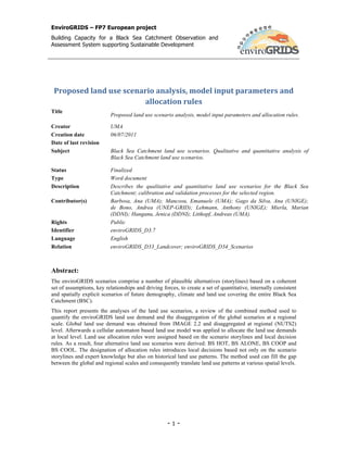
- 34. EnviroGRIDS – FP7 European project Building Capacity for a Black Sea Catchment Observation and Assessment System supporting Sustainable Development 4.1.2 Random parameter The random parameter interprets land use change in a cell that does not follow the behaviour defined by ordinary rules, representing the uncertainty of cell allocation. In the model, the setting value can vary from 0.1 to 1, where an increase in the factor leads to an increase in the scatter of the cell distribution in the final land use map. This value has to be adjusted until the results approximate the reference data. 4.1.3 Suitability maps A suitability map is assigned for each land use type, representing the probability of change in the future, and can be created though logistic regression or multi-criteria methods (Pontius and Schneider, 2001). The suitability maps created for Metronamica were based on contingency tables drawn up to evaluate the relationship between land use change and driving factors. Each land use class was crossed with a physical factor, to underline the frequency of distribution per land use classes. The results were studied and compared through graphics and matrices. At the end of this procedure, the significant factors that were taken into account to generate suitability maps were the following: elevation, slope, soil quality, mean annual temperature and annual precipitation. ESRI ArcGIS and Overlay tools (RIKS, 2006) were used to prepare these maps. The resulting overlay map represents the suitability of a given cell to maintain a particular land use (Uljee et al., 2006). Land use suitability is represented on a scale ranging between 1 and 10. Figure 21 shows the suitability map for forest, where 1 represents a low probability that forest will occur and 10 a high probability that forest will occur. Figure 21: Example of a suitability map for forest The annual mean temperature and annual precipitation applied in the generation of the suitability maps are climate surfaces with a spatial resolution of 1 km, from WorldClim. The WorldClim climate surfaces were generated by interpolation using the thin-plate smoothing spline algorithm (WorldClim; Hijmans et al., 2005) from the average monthly climate data from weather stations for the period 1950–2000 (Figure 22). - 34 -
- 35. EnviroGRIDS – FP7 European project Building Capacity for a Black Sea Catchment Observation and Assessment System supporting Sustainable Development Climate stations with mean Climate stations with temperature data precipitation data Figure 22: WorldClim weather stations (source: WorldClim, 2005) The suitability maps were updated after the calibration process with the mean annual temperature and annual precipitation projections for 2050. Initially the climate projections were obtained from the WorldClim datasets for the available IPCC climate scenarios (A1, A2 and B2), downscaled from the third- generation coupled global climate model (Ramirez and Jarvis, 2010). Subsequently the climate surfaces were replaced with more accurate climate surfaces derived from the downscaling of the PRUDENCE regional climate model to the BSC weather stations (enviroGRIDS_D3.2). 4.1.4 Accessibility effects Accessibility is an expression of the ease with which an activity can fulfil its need for transportation and mobility in a particular cell based on the transport system (RIKS, 2008). These effects are based on rail networks, rail stations and road networks with major and secondary roads extracted from the ESRI base maps database (Global Road Data, 2006; ESRI Data & Maps, 2006). First, these datasets are each edited into single shape files with an additional field [acctype] to establish a priority order among the data. When entered in the model, a weight is assigned according to the function land use class. Therefore the model recognizes the areas which are affected in a positive or negative way by the infrastructure network. The influence of the infrastructure network will be greater on urban spread and the emergence of new allocation sites. Urban areas are more likely to grow the closer they are to a road or rail network. In contrast, the presence of an infrastructure network has little influence on the other land use classes. In the case of cropland, roads are a minimum requirement, while no particular weight will be assigned for grassland and forest as no direct relation is recognized. Figure 23 shows the accessibility map for urban areas. Green represents high accessibility for urban areas, and red indicates low accessibility for urban areas. - 35 -