![Objective #1 ,[object Object],Weathering slides modified from work done by Caitlin F., Julianne R., Courtney G., Elizabeth R., Miranda B., Katie T., Mick M. and Brandan S..](data:image/gif;base64,R0lGODlhAQABAIAAAAAAAP///yH5BAEAAAAALAAAAAABAAEAAAIBRAA7)
Empfohlen
Weitere ähnliche Inhalte
Was ist angesagt?
Was ist angesagt? (20)
Andere mochten auch
Andere mochten auch (20)
Ähnlich wie Unit Iv Powerpoint
Ähnlich wie Unit Iv Powerpoint (20)
Kürzlich hochgeladen
Kürzlich hochgeladen (20)
Unit Iv Powerpoint
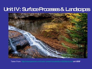
- 1. Unit IV: Surface Processes & Landscapes Taken From: http://www-personal.umich.edu/~jensenl/visuals/album/2006/pictured/ on 1/5/07
- 17. Chemical weathering dominates in warm and humid climates such as Florida or a Rain Forest. 1/3/07 Taken from: http://www.blueplanetbiomes.org/climate.htm Generally, the more moisture, the more weathering that takes place. Weathering Review
- 21. The Dirt on Soil Soil slides modified from work done by Devon M., Macy T., Cody G., Cory H., Will M. and Cory W. www.island2000.org.uk 1/7/08 Objective #4: Describe how soil is formed, the different types and how it can be conserved.
- 23. Soil Formation Soil formation Is the production of soil, particles of rocks, and minerals, and organic matter. The formation of soil happens over a very long period of time. It can take up to 1000 years. Soil is formed from the weathering of rocks and minerals. Rocks from the surface go through a process of weathering and break down into smaller pieces. From there it is mixed with other organic matter, and over time creates a thin layer of soil. http://library.thinkquest.org/J003195F/soil.htm on 1/7/08 http://images.encarta.msn.com/xrefmedia/aencmed/targets/illus/ilt/T045308A.gif on1/7/08
- 24. S oil C omposition Soils are a mixture of different things; rocks, minerals, and dead, decaying plants and animals. Soil can be very different from one location to another, but generally consists of organic and inorganic materials, water and air. www.macaulay.ac.uk on 1/8/08
- 29. here There are many soil horizons the first is the O Horizon . This is made up of leaf litter and humus. A Horizon this is the second horizon it is called topsoil. It is made of humus and mineral particles. E Horizon this is the third horizon. This layer is made up of mostly sand and silt. B Horizon this is the fourth horizon. The B horizon contains clay and mineral deposits that it receives from the layers above when water drips through. C Horizon This is the fifth horizon that is made of slightly broken up bedrock. Plant roots do not penetrate into this layer. R Horizon This is the sixth horizon. This is the bedrock layer. Soil Horizons Diagram http://www.enchantedlearning.com/geology/soil/ 1/8/08
- 39. Explain the difference between residual and transported sediments Objective # 6
- 62. Taken from http:// www.paleocurrents.com/castle_rock/docs/meandering_river.htm on 1-03-07 Taken from clip art on 1-4-07 Stream Diagrams Erosion point Deposition point The stream is fastest at this point
- 68. Objective #10 Describe ocean waves, the parts of a wave and what creates a wave. Ocean slides modified from work done by Andrew G., Jeremiah S., Mike H. and Jamie S.
- 73. OBJECTIVE #11 Know the difference between beach and shoreline vocabulary: jetties, groins, refraction and longshore current
- 77. http://www.south-seas-adventures.com/Gallery/South_Pacific_Beaches_1/image001.htm#description (1/3/07) When a wave reaches shallow water along the shore, FRICTION causes the bottom of the wave to move more slowly than the CREST witch falls over on the shore forming a breaker resulting in the foaming water called SURF . Friction is whatever gets in the way of a smooth and uninterrupted flow of events www.glossika.com/articles/re-energize_your_business.php (1/3/07)
- 78. The water that hits shore is pulled back by GRAVITY and this backwash rolls beach materials toward the ocean. If the waves strike the shoreline at an angle, they form a LONGSHORE current in the SURF ZONE witch moves sediment parallel to the coast. Beach sand is transported by longshore currents are deposited farther along the Cost. http://en.wikipedia.org/wiki/Image:Longshoredrift.gif (1/5/07)
- 79. Coastal communities may build walls ( GROINS ) perpendicular to the shore to prevent this removal of sand. Rock barriers ( JETTIES ) are also built on both sides of a harbor entrance to slow sedimentation which would clog the entrance to the harbor. JETTIES http://texascoastgeology.com/passes/Packery%20jetties%207-22-05.jpg (1/8/07) GROINS http://www.msstate.edu/dept/geosciences/CT/TIG/WEBSITES/RESEARCH/Gregory_Harris/shorel_jpg.jpg (1/8/07)
- 80. Objective #12 What is deposition? Describe 4 factors that affect deposition and how both vertical and horizontal sorting occur. Deposition slides modified from work done by Korrey R., Tiffany B., Anthony B., Pete L., Scott H. and Jessica W.
- 81. Deposition Deposition is the process by which sediments carried by a transporting agent are dropped from the medium . Deposition is also called sedimentation. Final deposition occurs at the end of a stream and losses velocity upon entering a larger body of water. Ex. Lakes, oceans, ect . http://physics.uwstout.edu/geo/sect5.htm January, 4 th , 2007 Picture of a sandbar. It shows the sand and rocks and sand on the shallow part of a lake, to show the dropping off of rocks and minerals.
- 82. Four Factors Affecting Deposition Particle size Particle shape Particle density http://pds-rings.seti.org/saturn/artwork/plate_07.gif 1/7/08 http://www.vacet.org/gallery/images_video/particle-heightfield_sm.png 1/7/08 www.rsc.org/ejga/JM/2006/b513095f-ga.gif 1/7/08 Stream Velocity
- 87. Horizontal Sorting When a body of water loses velocity, and particles with greater weight and density settle first it is called Horizontal Sorting. This sorts sediments according to size along the river bed. http://www.mrsciguy.com/sciimages/horizontal.jpg January 8th, 2007 Picture of Larger rocks and sediments like boulders and cobbles, being dropped off before the smaller rocks and sediments such as sand, salt and clay. Animation
- 88. Vertical Sorting Vertical Sorting (Graded Bedding) is deposition is very rapid and different sorting occurs. The particles are sorted on top of one another alternating bands of large to small sediments. http://www.geog.uu.nl/fg/mkleinhans/publicat/conf/gbr5/kleinhans5.htm January 10 th , 2007 Vertical Sorting separated the sand & pebbles into bands. http://regentsprep.org/Regents/earthsci/ January 10th 2007
- 91. Crossbedding Changes in direction of the wind that results in the layers or beds of sediment being deposited at different angles is called Crossbedding. http://epod.usra.edu/archive/epodviewer.php3?oid=131328 January 10 th 2007 Picture of part of the Bright Angel Trail in the Grand Canyon. The angled strips are caused by wind blowing sand towards the rock and the sand (sandblasting) causes the rock to weather.
- 93. Glacier slides modified from work done by Skyler B., Carissa C., Amber D., Jessica H., Robert F. and Robert K. Glaciers A Glacier in Canada http://www.nsf.gov/od/lpa/news/02/images/glacier_hi.jpg 1/3/08 Glacial Glossary link
- 95. Glaciers are found at high altitudes and at high latitudes also known as high mountains. http://images.google.com/imgres?imgurl=http://imagecache2.allposters.com/images/pic/NIM/KC356~Matunuska-Glacier-Alaska-Posters.jpg&imgrefurl=http://www.allposters.com/-sp/Matunuska-Glacier-Alaska-Posters_i310875_.htm&h=450&w=320&sz=26&hl=en&start=10&tbnid=vW1tM6L6yZi6PM:&tbnh=127&tbnw=90&prev=/images%3Fq%3DGlacier%26gbv%3D2%26svnum%3D10%26hl%3Den on January 4, 2008 Where are Glaciers found? It must be cold!
- 99. Alpine Glaciers carve U-shaped valleys.
- 100. Alpine Glaciers form cirques, horns, tarns & arétes.
- 102. Sediments frozen in the bottom of the glacier gouge out parallel striations or grooves in the bedrock over which the glacier passes. These striations or grooves indicate the direction of moving the glacier. In new York state, rounding of rock surfaces and glacial striations in both the Catskills and Adirondacks mountains show that glaciers at least one mile deep covered NYS http://www.ux1.eiu.edu/~cfjps/1300/striae2.JPG 1/16/08 Parallel Striations
- 103. Striations can be observed at about 4000 feet elevation on Hunter Mountain in the Catskills. They show that the ice was a minimum of a mile thick over this part of New York State. Thomas McGuire, Cave Creek, AZ Author, Amsco School Publications, NY
- 105. Occasionally an erratic is left perched on top of smaller boulders after many years of erosion. This perched erratic is at North Salem in Westchester County. Thomas McGuire, Cave Creek, AZ Author, Amsco School Publications, NY
- 108. Hundreds of drumlins lie between Rochester and Syracuse, NY. This is part of a drumlin field east of Rochester. Note that the trailing ends of the hills are the southern slopes. The north slopes are usually more blunt. Thomas McGuire, Cave Creek, AZ Author, Amsco School Publications, NY
- 113. The Finger Lakes of Western New York State were excavated as U-shaped valleys by the glaciers advancing to the south. Moraines dammed the former south flowing outlet rivers. Thomas McGuire, Cave Creek, AZ Author, Amsco School Publications, NY
- 115. The average global temperatures over the past 1000,000 years. Thomas McGuire, Cave Creek, AZ Author, Amsco School Publications, NY
- 116. Ice coverage of North America approximately 21,000 years ago Thomas McGuire, Cave Creek, AZ Author, Amsco School Publications, NY
- 118. The Ronkonkoma Moraine dips below sea level at Montauk Point. This is New York’s most eastern landfall. Note the boulders washed out of the moraine. Thomas McGuire, Cave Creek, AZ Author, Amsco School Publications, NY
- 124. Objective #16 Compare landscape characteristics for plains, plateaus, and mountains Landscape slides made by Eric H-W., Sara A. and Mark W. in January 2007. Modified by Mr. O.
- 125. D. Landscape Characteristics I. Landscape Regions Distinctive landscape regions can be identified by sets of landscape characteristics that seem to occur together . These characteristics help classify landscapes into mountains , plateaus or plains . relief- difference between the highest elevation and the lowest http://www.picturesofplaces.com Picture of grand canyon
- 126. Relief & Elevation Rock Layers High relief, high elevation deformed rock structure Moderate relief, high elevation horizontal rock structure Low relief, low elevation horizontal rock layers Mountains Plateaus Plains http:// www.freenaturepictures.com
- 127. Generally landscape regions have well-defined boundaries separated by natural boundaries such as mountains and bodies of water. The United States and New York State have a number of different landscape regions. The landscape regions for NYS are found on ESRT p. 2. http:// www.wvhighlands.org
- 129. Objective #17 Describe how Geological Forces, Climate, Bedrock type, Time and Human Activities influence the development of landscapes
- 130. II. Factors influencing landscape development
- 135. The angular and jagged landscapes of the Southwest such as at Monument Valley in Arizona, indicate an area that was never covered by continental glaciers. Thomas McGuire, Cave Creek, AZ Author, Amsco School Publications, NY
- 141. Rectangular Drainage A. B. C. D. Trellis Drainage Dendritic Drainage Radial Drainage