SlideShare ist ein Scribd-Unternehmen logo
1 von 3
Fieldtrip GB
High quality background
maps offering
rich data in both urban
and rural environments
Cache maps
to allow off-
network
usage
Design your
own data
capture
Manage your data through
the Authoring tool
Export data to
csv/KML/GeoJSON
Great Maps ManageCustomiseOffline
iPhone/iPad and Android
Compatible
Free in iStore and PlayStore
http://fieldtripgb.blogs.edina.ac.uk/
Citizen Science
http://fieldtripgb.blogs.edina.ac.uk/
•Get a new Dropbox account to share with your team
•Download Fieldtrip GB to your devices1.Before you start
•Log into the Authoring Tool
•Create a custom form and save it2. Design your form
•Get the team to log into the Dropbox account
•Use Sync to get the form on their devices3. Share the form
•Collect data using the form
•Manually correct remote points or in urban canyons4. In the field
•Connect to WiFi
•Get the team Sync to upload the data5. Back indoors
•Log into Authoring Tool
•Filter by form name and edit points if needed6. Manage your data
•Export to a KML file, GeoJSON, CSV or WMS
•Map the points in Google Earth, OpenLayers or a GIS7. View the results
What’s coming?
• Fieldtrip Open
– Based on WGS84 and OSM data
– Use it beyond GB
• Overlays
– Upload geotiff/geojpg to have access to satellite
images, historic maps, geology maps, landcover
• Better integration with Digimap
• Additional cloud service integration
• GitHUB – it’s already there as an open source
project
http://fieldtripgb.blogs.edina.ac.uk/

Weitere ähnliche Inhalte

Was ist angesagt?

AON building
AON buildingAON building
AON building
archihow
 

Was ist angesagt? (20)

Preparing LiDAR for Use in ArcGIS 10.1 with the Data Interoperability Extension
Preparing LiDAR for Use in ArcGIS 10.1 with the Data Interoperability ExtensionPreparing LiDAR for Use in ArcGIS 10.1 with the Data Interoperability Extension
Preparing LiDAR for Use in ArcGIS 10.1 with the Data Interoperability Extension
 
Global mapper
Global mapperGlobal mapper
Global mapper
 
SEPA - Esri UK Annual Conference 2016
SEPA - Esri UK Annual Conference 2016SEPA - Esri UK Annual Conference 2016
SEPA - Esri UK Annual Conference 2016
 
Map Styling Tools and Interactive maps on the web with OpenLayers - Addy Pope...
Map Styling Tools and Interactive maps on the web with OpenLayers - Addy Pope...Map Styling Tools and Interactive maps on the web with OpenLayers - Addy Pope...
Map Styling Tools and Interactive maps on the web with OpenLayers - Addy Pope...
 
Python and GIS: Improving Your Workflow
Python and GIS: Improving Your WorkflowPython and GIS: Improving Your Workflow
Python and GIS: Improving Your Workflow
 
2013 Vendor Track, LiDAR Processing and Terrain Analysis in Global Mapper by ...
2013 Vendor Track, LiDAR Processing and Terrain Analysis in Global Mapper by ...2013 Vendor Track, LiDAR Processing and Terrain Analysis in Global Mapper by ...
2013 Vendor Track, LiDAR Processing and Terrain Analysis in Global Mapper by ...
 
Sharing information through web applications - Smart Collaboration - Esri UK ...
Sharing information through web applications - Smart Collaboration - Esri UK ...Sharing information through web applications - Smart Collaboration - Esri UK ...
Sharing information through web applications - Smart Collaboration - Esri UK ...
 
Prepare LiDAR Data To Meet Your Requirements
Prepare LiDAR Data To Meet Your RequirementsPrepare LiDAR Data To Meet Your Requirements
Prepare LiDAR Data To Meet Your Requirements
 
Smart Mapping - How to Create Stunning Maps - Esri UK Annual Conference 2016
Smart Mapping - How to Create Stunning Maps - Esri UK Annual Conference 2016Smart Mapping - How to Create Stunning Maps - Esri UK Annual Conference 2016
Smart Mapping - How to Create Stunning Maps - Esri UK Annual Conference 2016
 
Developing a Crowd Sourcing App
Developing a Crowd Sourcing AppDeveloping a Crowd Sourcing App
Developing a Crowd Sourcing App
 
Shrug 2018 color adjusting aerial imagery presentation part 1
Shrug 2018 color adjusting aerial imagery presentation part 1Shrug 2018 color adjusting aerial imagery presentation part 1
Shrug 2018 color adjusting aerial imagery presentation part 1
 
HighAccuracyDataCollection
HighAccuracyDataCollectionHighAccuracyDataCollection
HighAccuracyDataCollection
 
Supporting Situational Awareness at LAX using FME Server
Supporting Situational Awareness at LAX using FME ServerSupporting Situational Awareness at LAX using FME Server
Supporting Situational Awareness at LAX using FME Server
 
How to Get the Most Out of LiDAR Data
How to Get the Most Out of LiDAR DataHow to Get the Most Out of LiDAR Data
How to Get the Most Out of LiDAR Data
 
ArcGIS Data Interoperability: Tips for LiDAR, 3D, and BIM
ArcGIS Data Interoperability: Tips for LiDAR, 3D, and BIMArcGIS Data Interoperability: Tips for LiDAR, 3D, and BIM
ArcGIS Data Interoperability: Tips for LiDAR, 3D, and BIM
 
Transforming Rasters and Point Clouds
Transforming Rasters and Point CloudsTransforming Rasters and Point Clouds
Transforming Rasters and Point Clouds
 
Advanced Analytics - Smart Analytics - Esri UK Annual Conference 2017
Advanced Analytics - Smart Analytics - Esri UK Annual Conference 2017Advanced Analytics - Smart Analytics - Esri UK Annual Conference 2017
Advanced Analytics - Smart Analytics - Esri UK Annual Conference 2017
 
Exploring KML Transformers
Exploring KML TransformersExploring KML Transformers
Exploring KML Transformers
 
The 'right' choices in GIS - Grontmij
The 'right' choices in GIS - GrontmijThe 'right' choices in GIS - Grontmij
The 'right' choices in GIS - Grontmij
 
AON building
AON buildingAON building
AON building
 

Andere mochten auch

Andere mochten auch (16)

Geoservices Support - Carol Blackwood
Geoservices Support - Carol BlackwoodGeoservices Support - Carol Blackwood
Geoservices Support - Carol Blackwood
 
Flood Forecasting - Peter Gibbs
Flood Forecasting - Peter GibbsFlood Forecasting - Peter Gibbs
Flood Forecasting - Peter Gibbs
 
Using EDINA Datasets in a Hydrology Project - Darius Bazazi
Using EDINA Datasets in a Hydrology Project - Darius BazaziUsing EDINA Datasets in a Hydrology Project - Darius Bazazi
Using EDINA Datasets in a Hydrology Project - Darius Bazazi
 
Digimap and GIS teaching at Lancaster University - Geoforum 2016 - Duncan Why...
Digimap and GIS teaching at Lancaster University - Geoforum 2016 - Duncan Why...Digimap and GIS teaching at Lancaster University - Geoforum 2016 - Duncan Why...
Digimap and GIS teaching at Lancaster University - Geoforum 2016 - Duncan Why...
 
Digimap - Copyright and Terms of use
Digimap - Copyright and Terms of useDigimap - Copyright and Terms of use
Digimap - Copyright and Terms of use
 
Geoforum - Digimap Update 2015
Geoforum - Digimap Update 2015Geoforum - Digimap Update 2015
Geoforum - Digimap Update 2015
 
Using Digimap data for Archaeology - Geoforum 2016 - Kathleen O'Donnell
Using Digimap data for Archaeology - Geoforum 2016 - Kathleen O'DonnellUsing Digimap data for Archaeology - Geoforum 2016 - Kathleen O'Donnell
Using Digimap data for Archaeology - Geoforum 2016 - Kathleen O'Donnell
 
New Cartography in Digimap - Geoforum 2016 - Tim Urwin
New Cartography in Digimap - Geoforum 2016 - Tim UrwinNew Cartography in Digimap - Geoforum 2016 - Tim Urwin
New Cartography in Digimap - Geoforum 2016 - Tim Urwin
 
Creating Physical Models with Digimap Data
Creating Physical Models with Digimap DataCreating Physical Models with Digimap Data
Creating Physical Models with Digimap Data
 
Data, Data, Data - Geoforum 2016 - Phil Bartie
Data, Data, Data - Geoforum 2016 - Phil BartieData, Data, Data - Geoforum 2016 - Phil Bartie
Data, Data, Data - Geoforum 2016 - Phil Bartie
 
Visualising geographical information in augmented reality - Geoforum 2016 - T...
Visualising geographical information in augmented reality - Geoforum 2016 - T...Visualising geographical information in augmented reality - Geoforum 2016 - T...
Visualising geographical information in augmented reality - Geoforum 2016 - T...
 
Cartography at the Ordnance Survey
Cartography at the Ordnance SurveyCartography at the Ordnance Survey
Cartography at the Ordnance Survey
 
Aerial Photography - Geoforum 2016 - Richard Evans, Getmapping
Aerial Photography - Geoforum 2016 - Richard Evans, GetmappingAerial Photography - Geoforum 2016 - Richard Evans, Getmapping
Aerial Photography - Geoforum 2016 - Richard Evans, Getmapping
 
Big data in Digimap
Big data in DigimapBig data in Digimap
Big data in Digimap
 
Introduction to Edinburgh University Data Library and national data services
Introduction to Edinburgh University Data Library and national data servicesIntroduction to Edinburgh University Data Library and national data services
Introduction to Edinburgh University Data Library and national data services
 
RIOXX: a Modern Metadata Application Profile
RIOXX: a Modern Metadata Application ProfileRIOXX: a Modern Metadata Application Profile
RIOXX: a Modern Metadata Application Profile
 

Ähnlich wie Citizen Science in your Pocket - Addy Pope

Scoping call presentation_rev_4_mary
Scoping call presentation_rev_4_maryScoping call presentation_rev_4_mary
Scoping call presentation_rev_4_mary
rhochambeau32
 
Kml Basics Chpt 1 Overview
Kml Basics Chpt  1   OverviewKml Basics Chpt  1   Overview
Kml Basics Chpt 1 Overview
tcooper66
 

Ähnlich wie Citizen Science in your Pocket - Addy Pope (20)

Fieldtrip GB: a bespoke data capture app to support field trips - Addy Pope
Fieldtrip GB: a bespoke data capture app to support field trips - Addy PopeFieldtrip GB: a bespoke data capture app to support field trips - Addy Pope
Fieldtrip GB: a bespoke data capture app to support field trips - Addy Pope
 
Digital maps: past, present; on your desktop and in the palm of your hand
Digital maps: past, present; on your desktop and in the palm of your handDigital maps: past, present; on your desktop and in the palm of your hand
Digital maps: past, present; on your desktop and in the palm of your hand
 
Maps and Apps
Maps and AppsMaps and Apps
Maps and Apps
 
Collector app mipn presentation
Collector app mipn presentationCollector app mipn presentation
Collector app mipn presentation
 
Cabaret of Dangerous Ideas Presentation on FieldTrip GB
Cabaret of Dangerous Ideas Presentation on FieldTrip GBCabaret of Dangerous Ideas Presentation on FieldTrip GB
Cabaret of Dangerous Ideas Presentation on FieldTrip GB
 
How to Create a ArcGIS Story Map Final Presentation
How to Create a ArcGIS Story Map Final Presentation How to Create a ArcGIS Story Map Final Presentation
How to Create a ArcGIS Story Map Final Presentation
 
Mobile data collection using odk
Mobile data collection using odkMobile data collection using odk
Mobile data collection using odk
 
48-Hour Assessment Mobile Apps Tool on Food Security in Bangladesh
48-Hour Assessment Mobile Apps Tool on Food Security in Bangladesh 48-Hour Assessment Mobile Apps Tool on Food Security in Bangladesh
48-Hour Assessment Mobile Apps Tool on Food Security in Bangladesh
 
odkk.pptx
odkk.pptxodkk.pptx
odkk.pptx
 
kobo_briefing.pptx
kobo_briefing.pptxkobo_briefing.pptx
kobo_briefing.pptx
 
Google Earth Tutorials - Part I
Google Earth Tutorials - Part IGoogle Earth Tutorials - Part I
Google Earth Tutorials - Part I
 
Introduction to Digimap's Ordnance Survey Collection
Introduction to Digimap's Ordnance Survey CollectionIntroduction to Digimap's Ordnance Survey Collection
Introduction to Digimap's Ordnance Survey Collection
 
Derek France Storymaps
Derek France   StorymapsDerek France   Storymaps
Derek France Storymaps
 
Geokov
GeokovGeokov
Geokov
 
Scoping call presentation_rev_4_mary
Scoping call presentation_rev_4_maryScoping call presentation_rev_4_mary
Scoping call presentation_rev_4_mary
 
EDINA Geoservices: Geological Society Higher Education Network 2015
EDINA Geoservices: Geological Society Higher Education Network 2015EDINA Geoservices: Geological Society Higher Education Network 2015
EDINA Geoservices: Geological Society Higher Education Network 2015
 
Kml Basics Chpt 1 Overview
Kml Basics Chpt  1   OverviewKml Basics Chpt  1   Overview
Kml Basics Chpt 1 Overview
 
Esriuk_track4_bird_life
Esriuk_track4_bird_lifeEsriuk_track4_bird_life
Esriuk_track4_bird_life
 
Edina Geoservices Review - Emma Diffley
Edina Geoservices Review - Emma DiffleyEdina Geoservices Review - Emma Diffley
Edina Geoservices Review - Emma Diffley
 
Research Data Management and Spatial Data
Research Data Management and Spatial DataResearch Data Management and Spatial Data
Research Data Management and Spatial Data
 

Mehr von EDINA, University of Edinburgh

Mehr von EDINA, University of Edinburgh (20)

The Making of the English Landscape:
The Making of the English Landscape: The Making of the English Landscape:
The Making of the English Landscape:
 
Spatial Data, Spatial Humanities
Spatial Data, Spatial HumanitiesSpatial Data, Spatial Humanities
Spatial Data, Spatial Humanities
 
Land Cover Map 2015
Land Cover Map 2015Land Cover Map 2015
Land Cover Map 2015
 
We have the technology... We have the data... What next?
We have the technology... We have the data... What next?We have the technology... We have the data... What next?
We have the technology... We have the data... What next?
 
Reference Rot in Theses: A HiberActive Pilot - 10x10 session for Repository F...
Reference Rot in Theses: A HiberActive Pilot - 10x10 session for Repository F...Reference Rot in Theses: A HiberActive Pilot - 10x10 session for Repository F...
Reference Rot in Theses: A HiberActive Pilot - 10x10 session for Repository F...
 
GeoForum EDINA report 2017
GeoForum EDINA report 2017GeoForum EDINA report 2017
GeoForum EDINA report 2017
 
If I Googled You, What Would I Find? Managing your digital footprint - Nicola...
If I Googled You, What Would I Find? Managing your digital footprint - Nicola...If I Googled You, What Would I Find? Managing your digital footprint - Nicola...
If I Googled You, What Would I Find? Managing your digital footprint - Nicola...
 
Moray housemarch2017
Moray housemarch2017Moray housemarch2017
Moray housemarch2017
 
Uniof stirlingmarch2017secondary
Uniof stirlingmarch2017secondaryUniof stirlingmarch2017secondary
Uniof stirlingmarch2017secondary
 
Uniof glasgow jan2017_secondary
Uniof glasgow jan2017_secondaryUniof glasgow jan2017_secondary
Uniof glasgow jan2017_secondary
 
Managing your Digital Footprint : Taking control of the metadata and tracks a...
Managing your Digital Footprint : Taking control of the metadata and tracks a...Managing your Digital Footprint : Taking control of the metadata and tracks a...
Managing your Digital Footprint : Taking control of the metadata and tracks a...
 
Social media and blogging to develop and communicate research in the arts and...
Social media and blogging to develop and communicate research in the arts and...Social media and blogging to develop and communicate research in the arts and...
Social media and blogging to develop and communicate research in the arts and...
 
Enhancing your research impact through social media - Nicola Osborne
Enhancing your research impact through social media - Nicola OsborneEnhancing your research impact through social media - Nicola Osborne
Enhancing your research impact through social media - Nicola Osborne
 
Social Media in Marketing in Support of Your Personal Brand - Nicola Osborne
Social Media in Marketing in Support of Your Personal Brand - Nicola OsborneSocial Media in Marketing in Support of Your Personal Brand - Nicola Osborne
Social Media in Marketing in Support of Your Personal Brand - Nicola Osborne
 
Best Practice for Social Media in Teaching & Learning Contexts - Nicola Osborne
Best Practice for Social Media in Teaching & Learning Contexts - Nicola OsborneBest Practice for Social Media in Teaching & Learning Contexts - Nicola Osborne
Best Practice for Social Media in Teaching & Learning Contexts - Nicola Osborne
 
SCURL and SUNCAT serials holdings comparison service
SCURL and SUNCAT serials holdings comparison serviceSCURL and SUNCAT serials holdings comparison service
SCURL and SUNCAT serials holdings comparison service
 
Digimap for Schools: Introduction to an ICT based cross curricular resource f...
Digimap for Schools: Introduction to an ICT based cross curricular resource f...Digimap for Schools: Introduction to an ICT based cross curricular resource f...
Digimap for Schools: Introduction to an ICT based cross curricular resource f...
 
What is Crowdsourcing - Nicola Osborne
What is Crowdsourcing - Nicola OsborneWhat is Crowdsourcing - Nicola Osborne
What is Crowdsourcing - Nicola Osborne
 
Repository Fringe 2016 - Survey Documentation and Analysis
Repository Fringe 2016 - Survey Documentation and AnalysisRepository Fringe 2016 - Survey Documentation and Analysis
Repository Fringe 2016 - Survey Documentation and Analysis
 
EPSRC research data expectations and PURE for datasets
EPSRC research data expectations and PURE for datasetsEPSRC research data expectations and PURE for datasets
EPSRC research data expectations and PURE for datasets
 

Kürzlich hochgeladen

Cloud Frontiers: A Deep Dive into Serverless Spatial Data and FME
Cloud Frontiers:  A Deep Dive into Serverless Spatial Data and FMECloud Frontiers:  A Deep Dive into Serverless Spatial Data and FME
Cloud Frontiers: A Deep Dive into Serverless Spatial Data and FME
Safe Software
 
Why Teams call analytics are critical to your entire business
Why Teams call analytics are critical to your entire businessWhy Teams call analytics are critical to your entire business
Why Teams call analytics are critical to your entire business
panagenda
 

Kürzlich hochgeladen (20)

Cloud Frontiers: A Deep Dive into Serverless Spatial Data and FME
Cloud Frontiers:  A Deep Dive into Serverless Spatial Data and FMECloud Frontiers:  A Deep Dive into Serverless Spatial Data and FME
Cloud Frontiers: A Deep Dive into Serverless Spatial Data and FME
 
Apidays New York 2024 - The value of a flexible API Management solution for O...
Apidays New York 2024 - The value of a flexible API Management solution for O...Apidays New York 2024 - The value of a flexible API Management solution for O...
Apidays New York 2024 - The value of a flexible API Management solution for O...
 
Manulife - Insurer Innovation Award 2024
Manulife - Insurer Innovation Award 2024Manulife - Insurer Innovation Award 2024
Manulife - Insurer Innovation Award 2024
 
Why Teams call analytics are critical to your entire business
Why Teams call analytics are critical to your entire businessWhy Teams call analytics are critical to your entire business
Why Teams call analytics are critical to your entire business
 
Strategies for Landing an Oracle DBA Job as a Fresher
Strategies for Landing an Oracle DBA Job as a FresherStrategies for Landing an Oracle DBA Job as a Fresher
Strategies for Landing an Oracle DBA Job as a Fresher
 
Tata AIG General Insurance Company - Insurer Innovation Award 2024
Tata AIG General Insurance Company - Insurer Innovation Award 2024Tata AIG General Insurance Company - Insurer Innovation Award 2024
Tata AIG General Insurance Company - Insurer Innovation Award 2024
 
presentation ICT roal in 21st century education
presentation ICT roal in 21st century educationpresentation ICT roal in 21st century education
presentation ICT roal in 21st century education
 
Boost PC performance: How more available memory can improve productivity
Boost PC performance: How more available memory can improve productivityBoost PC performance: How more available memory can improve productivity
Boost PC performance: How more available memory can improve productivity
 
Top 5 Benefits OF Using Muvi Live Paywall For Live Streams
Top 5 Benefits OF Using Muvi Live Paywall For Live StreamsTop 5 Benefits OF Using Muvi Live Paywall For Live Streams
Top 5 Benefits OF Using Muvi Live Paywall For Live Streams
 
Boost Fertility New Invention Ups Success Rates.pdf
Boost Fertility New Invention Ups Success Rates.pdfBoost Fertility New Invention Ups Success Rates.pdf
Boost Fertility New Invention Ups Success Rates.pdf
 
A Domino Admins Adventures (Engage 2024)
A Domino Admins Adventures (Engage 2024)A Domino Admins Adventures (Engage 2024)
A Domino Admins Adventures (Engage 2024)
 
Workshop - Best of Both Worlds_ Combine KG and Vector search for enhanced R...
Workshop - Best of Both Worlds_ Combine  KG and Vector search for  enhanced R...Workshop - Best of Both Worlds_ Combine  KG and Vector search for  enhanced R...
Workshop - Best of Both Worlds_ Combine KG and Vector search for enhanced R...
 
A Year of the Servo Reboot: Where Are We Now?
A Year of the Servo Reboot: Where Are We Now?A Year of the Servo Reboot: Where Are We Now?
A Year of the Servo Reboot: Where Are We Now?
 
Mastering MySQL Database Architecture: Deep Dive into MySQL Shell and MySQL R...
Mastering MySQL Database Architecture: Deep Dive into MySQL Shell and MySQL R...Mastering MySQL Database Architecture: Deep Dive into MySQL Shell and MySQL R...
Mastering MySQL Database Architecture: Deep Dive into MySQL Shell and MySQL R...
 
The 7 Things I Know About Cyber Security After 25 Years | April 2024
The 7 Things I Know About Cyber Security After 25 Years | April 2024The 7 Things I Know About Cyber Security After 25 Years | April 2024
The 7 Things I Know About Cyber Security After 25 Years | April 2024
 
Apidays Singapore 2024 - Building Digital Trust in a Digital Economy by Veron...
Apidays Singapore 2024 - Building Digital Trust in a Digital Economy by Veron...Apidays Singapore 2024 - Building Digital Trust in a Digital Economy by Veron...
Apidays Singapore 2024 - Building Digital Trust in a Digital Economy by Veron...
 
Axa Assurance Maroc - Insurer Innovation Award 2024
Axa Assurance Maroc - Insurer Innovation Award 2024Axa Assurance Maroc - Insurer Innovation Award 2024
Axa Assurance Maroc - Insurer Innovation Award 2024
 
HTML Injection Attacks: Impact and Mitigation Strategies
HTML Injection Attacks: Impact and Mitigation StrategiesHTML Injection Attacks: Impact and Mitigation Strategies
HTML Injection Attacks: Impact and Mitigation Strategies
 
GenAI Risks & Security Meetup 01052024.pdf
GenAI Risks & Security Meetup 01052024.pdfGenAI Risks & Security Meetup 01052024.pdf
GenAI Risks & Security Meetup 01052024.pdf
 
🐬 The future of MySQL is Postgres 🐘
🐬  The future of MySQL is Postgres   🐘🐬  The future of MySQL is Postgres   🐘
🐬 The future of MySQL is Postgres 🐘
 

Citizen Science in your Pocket - Addy Pope

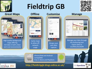
  • 1. Fieldtrip GB High quality background maps offering rich data in both urban and rural environments Cache maps to allow off- network usage Design your own data capture Manage your data through the Authoring tool Export data to csv/KML/GeoJSON Great Maps ManageCustomiseOffline iPhone/iPad and Android Compatible Free in iStore and PlayStore http://fieldtripgb.blogs.edina.ac.uk/
  • 2. Citizen Science http://fieldtripgb.blogs.edina.ac.uk/ •Get a new Dropbox account to share with your team •Download Fieldtrip GB to your devices1.Before you start •Log into the Authoring Tool •Create a custom form and save it2. Design your form •Get the team to log into the Dropbox account •Use Sync to get the form on their devices3. Share the form •Collect data using the form •Manually correct remote points or in urban canyons4. In the field •Connect to WiFi •Get the team Sync to upload the data5. Back indoors •Log into Authoring Tool •Filter by form name and edit points if needed6. Manage your data •Export to a KML file, GeoJSON, CSV or WMS •Map the points in Google Earth, OpenLayers or a GIS7. View the results
  • 3. What’s coming? • Fieldtrip Open – Based on WGS84 and OSM data – Use it beyond GB • Overlays – Upload geotiff/geojpg to have access to satellite images, historic maps, geology maps, landcover • Better integration with Digimap • Additional cloud service integration • GitHUB – it’s already there as an open source project http://fieldtripgb.blogs.edina.ac.uk/