

Empfohlen
Weitere ähnliche Inhalte
Was ist angesagt?
Was ist angesagt? (20)
Ähnlich wie Satellite Sys
Ähnlich wie Satellite Sys (20)
Kürzlich hochgeladen
Kürzlich hochgeladen (20)
Satellite Sys
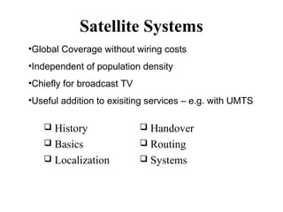
- 1. Satellite Systems •Global Coverage without wiring costs •Independent of population density •Chiefly for broadcast TV •Useful addition to exisiting services – e.g. with UMTS History Basics Localization Handover Routing Systems
- 2. History of satellite communication 1945 - Arthur C. Clarke “Extra Terrestrial Relays“ 1957 - first satellite USSR’s SPUTNIK 1960- first reflecting communication satellite ECHO 1962 – Telstar launched, an important step 1963 - first geostationary satellite SYNCOM 1965 - first commercial geostationary satellite “Early Bird” (INTELSAT I 68 kg): 240 duplex telephone channels or 1 TV channel, 1.5 years lifetime 1967-69 – Intelsat II, III; 1200 phone channels 1976 - three MARISAT satellites for maritime communication; 40W power, 1.2 m antenna
- 3. History (Contd) 1982 first mobile satellite telephone system INMARSAT-A 1988 first satellite system for mobile phones and data communication INMARSAT-C; 600 bps, interface to X.25 1993 INMARSAT-M - first digital satellite telephone system; still very heavy equipment 1998 global satellite systems for small mobile phones – Iridium & Globalstar Currently about 200 geo satellites.
- 4. Applications Traditional Weather, radio and TV broadcast military satellites – espionage, warning system navigation and localization (GPS) Telecommunication – ‘cable in the sky’ global telephone connections & mobiles backbone for global networks remote/rural areas extend cellular systems (AMPS, GSM UMTS), need low orbit satellites.
- 5. Satellite Functions Transponder Receive on one frequency, repeat on another frequency (transparent transponder) May amplify or regenerate (regenerative transponder) Inter satellite routing Error correction is essential
- 6. Classical satellite systems Inter Satellite Link (ISL) Mobile User Link (MUL) Gateway Link (GWL) MUL GWL small cells (spotbeams) base station or gateway footprint ISDN PSTN: Public Switched Telephone Network PSTN User data GSM
- 8. SATELLITE RECEPTION Footprint – area on earth’s surface where signal can be received LOS (Line of Sight) to the satellite necessary for connection Attenuation depends on distance, elevation, frequency of carrier and atmosphere High elevation means less absorption due to rain, fog, atmosphere and buildings; at least 10 degrees needed.
- 9. Signal Loss Calculation (qualitative only) Attenuation or power loss is determined by gain of sending/receiving antennae distance between sender and receiver Carrier frequency This affects data rates achievable Only 10 bps may be achievable with GEOs, compared to 10 Kbps at 100 km, 2GHz carrier 4π r f L= c L: Loss f: carrier frequency r: distance c: speed of light 2
- 10. Atmospheric attenuation Attenuation of the signal in % Example: satellite systems at 4-6 GHz 50 40 rain absorption 30 fog absorption ε 20 10 atmospheric absorption 5° 10° 20° 30° elevation of the satellite 40° 50°
- 11. Satellites - features GEO: geostationary, ~ 36000 km from the earth LEO (Low Earth Orbit): 500 - 1500 km MEO (Medium Earth Orbit) or ICO (Intermediate Circular Orbit): 6000 - 20000 km HEO (Highly Elliptical Orbit) elliptical orbits Microwave, line of sight; GHz range Uplink and downlink – different frequencies
- 13. Orbits II GEO (Inmarsat) HEO MEO (ICO) LEO (Globalstar, Irdium) inner and outer Van Allen belts earth 1000 10000 35768 km Inner & outer Van-Allen-Belts: ionized particles 2000 - 6000 km, 15000 - 30000 km altitude
- 14. Table 17.1 Satellite frequency bands Band Downlink, GHz Uplink, GHz Bandwidth, MHz L 1.5 1.6 15 S 1.9 2.2 70 C Ku 4 11 6 14 500 500 Ka 20 30 3500
- 15. Satellites in geosynchronous orbit Telephony, broadcast TV, Internet backbone
- 16. Geostationary satellites 35,786 km, equatorial (inclination 0°), 15 yrs life 24 hr period, synchronous to earth rotation fix antenna positions, no adjusting necessary large footprint (up to 34% of earth), limited frequency reuse; 3 satellites are enough to cover bad elevations in areas with latitude above 60° high transmit power 10KW, high latency (0.25 s) not for global coverage for small mobile phones and data transmission, suitable for radio & TV
- 17. MEOs – used for GPS 18000 km altitude 24 to cover the earth 6 hrs to orbit GPS based on ‘triangulation’ – need distance from 4 points Used widely by all sorts of users
- 18. LEO – global telephony Polar orbits, 500-2000 km 5-8 years lifetime 90-120 min to orbit 20000 – 25000 km/hr 8000 km diameter footprint System of satellites = network of switches Little Leos - < 1GHz, low data rate messaging Big Leos (1-3 GHz) – Globalstar, Iridium Broadband Leos (like fibre) - Teledesic
- 19. LEO systems visibility ~ 10 - 40 minutes, period of 95-120 min global radio coverage possible, 50-200 satellites latency similar to terrestrial long distance: 5 - 10 ms smaller footprints (i.e. cells), better frequency reuse handover necessary from one satellite to another High elevation even in polar regions more complex systems due to moving satellites Need for routing
- 20. LEOS ISL Inter Satellite Link GWL – Gateway Link UML – User Mobile Link
- 21. Iridium 1998 - present 66 satellites, 6 orbits, altitude 750 km. Originally for global voice, data, fax, paging, navigation Spectrum - 1.6 G, ISL 23 G 66 x 48 spot beams or cells 2000 cells to cover the earth 240 channels of 41 KHz each, can support 253 440 users. Applications – telephony ($7 per minute) and data 2.4 kbps (10 kbps under new ownership) Inter satellite links for routing 25 Mbps Complex software for call routing via ISL
- 22. Globalstar 48 Satellites, 6 orbits Altitude of 1400 km Relaying uses earth stations as well as satellites – ‘bent pipe’. Ground stations can create stronger signals Voice and data at 4.8 kbps
- 23. Teledesic – planned but never materialised 288 satellites, 12 polar orbits,1350 km BB channels – Internet in the sky 8 satellites form a unit, earth stations are also used Earth divided into several 10k’s cells, each assigned a time slot to transmit User terminals to communicate directly 155 M/1.2G up/down links – Ka band
- 24. Routing between satellites, gateways, fixed networks: ISL or terrestrial? Reduced number of gateways needed with ISL Best to forward connections or data packets within the satellite network as long as possible Only one uplink and one downlink per direction needed for the connection of two mobile phones
- 25. PROBLEMS - ISL more complex focusing of antennas between satellites satellites need routing software high system complexity due to moving routers higher fuel consumption, shorter lifetime Iridium and Teledesic planned with ISL Other systems use terrestrial gateways and also terrestrial networks
- 26. Localization of mobile stations Mechanisms similar to GSM, except ‘base stations’ are satellites. Gateways maintain registers with user data HLR (Home Location Register): static user data VLR (Visitor Location Register): (last known) location of the mobile station SUMR (Satellite User Mapping Register): satellite assigned to a mobile station positions of all satellites
- 27. Localisation of Mobiles Registration of mobile stations Mobile’s signal received by several satellites, reported to gateway(s) Localization of the mobile station is via the satellite’s position requesting user data from HLR updating VLR and SUMR Calling a mobile station localization using HLR/VLR similar to GSM connection setup using SUMR & the appropriate satellite
- 28. Handover in satellite systems More complex, due to motion of satellites Intra satellite handover handover from one spot beam to another mobile station still in the footprint of the satellite, but in another cell Inter satellite handover handover from one satellite to another satellite mobile station leaves the footprint of one satellite
- 29. Handover (Contd.) Gateway handover Handover from one gateway to another mobile station still in the footprint of a satellite, but satellite moves away from the current gateway Inter system handover Handover from the satellite network to a terrestrial cellular network mobile station can use a terrestrial network again which might be cheaper, have a lower latency.
- 30. Overview of LEO/MEO systems # satellites altitude (km) coverage min. elevation frequencies [GHz (circa)] access method ISL bit rate # channels Lifetime [years] cost estimation Iridium 66 + 6 780 Globalstar 48 + 4 1414 ICO 10 + 2 10390 Teledesic 288 ca. 700 global 8° ±70° latitude 20° global 20° global 40° 1.6 MS 29.2 ↑ 19.5 ↓ 23.3 ISL FDMA/TDMA 1.6 MS ↑ 2.5 MS ↓ 5.1 ↑ 6.9 ↓ CDMA 2 MS ↑ 2.2 MS ↓ 5.2 ↑ 7↓ FDMA/TDMA 19 ↓ 28.8 ↑ 62 ISL yes 2.4 kbit/s no 9.6 kbit/s no 4.8 kbit/s 4000 5-8 2700 7.5 4500 12 yes 64 Mbit/s ↓ 2/64 Mbit/s ↑ 2500 10 4.4 B$ 2.9 B$ 4.5 B$ 9 B$ FDMA/TDMA
Hinweis der Redaktion
- Satellites transmit pictures using IR/visible light. Used for predicting hurricanes. Radio & TV – alternative to cable; satellite dishes 4 m diameter typical GPS – precision of some metres possible. Used in ships and aircraft, trucks and cars. Can be used for fleet management, localisation of car in case of theft. For telephony, satellites are being overtaken by transcontinental fibre links – 10Gbps or even more in the laboratories. bandwidth. Also, shorter distances (10000 km v 72000 km), leading to lower propagation delay. In the UMTS system, frequencies for the S-Band satellite segment are 1980-2010 MHz (up) and 2170-2200 (down).
- Foorprint – area on the earth’s surface covered by satellite transmission. Smaller cells (spotbeams) are possible. Within a footprint, direct communication is possible using mobiles Between footprints, Intersatellite links or Gateway links are needed. Real challenge is to have smooth handover between all possible systems – UMTS, GSM, satellite
- Uplink: connection base station - satellite Downlink: connection satellite - base station typically separated frequencies for uplink and downlink
- Further classified into little (100 bps), big (1 kbps) and broadband (Mbps) Example – Globalstart 48 satellite system
- ICO = Intermediate Circular Orbit