SlideShare ist ein Scribd-Unternehmen logo
1 von 32
Downloaden Sie, um offline zu lesen
Clark Fork River Basin
Water Year Review 2012 & Outlook 2013
                                 by
                            Ray Nickless
                 Service Hydrologist – Missoula, MT
                                            ray.nickless@noaa.gov


   Lolo Pass Visitor Center – “La Nina” Winter 2011                 Forest Fires Summer 2012
Overview

• Weather Pattern & Climate
 (Water Year 2012)

• Streamflow volumes
 (Water Year 2012)

• Weather Outlook
 (Water year 2013)
Weather Pattern

 Water Year 2012
La Nina - Measured 2011-2012


70 Ocean Buoys


                                            Weather Balloons
La Nina 2011 – 2012
   (Wintertime Pattern)
Snowpack La Nina Years
     (Western Montana)
Precipitation & Temperature

       2012 - Water year
Precipitation
        2012 – Water Year

October 2011 through September 2012
New Record
  Kalispell
Tied Record
       Missoula
41 days without precipitation
Dry
         Butte
Entire 2012 water year


    68% of ave.
New Record
      Pierce, ID
87 days without precipitation
New Record
      Elk City, ID
32 days without precipitation
Temperatures
                (Warm)

Departure from Average Temperature
     October 2011 through September 2012
Drought
Lack of precipitation and warmer temperatures
Water Supply for Water Year 2012
         (A look back)
Streamflow Volumes (April through September)
                   Water Year 2012


                                       er
                         Blackfoot Riv
                          117% of ave.


        f av ver
     % o t Ri
            e.
 107 erroo


                                       Cl
                                          ar
                                       11 k F
      t


                                          2% ork
  Bit


                                             of Ri
                                               av ver
                                                 e.
Streamflow Volumes (April through September)
                 Water Year 2012


                         N
                          or
                            th
                            Fo 8
                              rk %
                              12

                                 Fl of
                                   at av
                                     he e.
                                       ad
                                          R
                                           iv
                                             er
                                          M
                                            id
                                              dl
                                                e
                                                  F
                                               12 ork
                                                  4 F
                Flathead River                      % la
                                                     of the
                127 % of ave.                          av ad
                                                         e. R
                               Hungry Horse Inflow           iv
                                                               er
                                  126 % of ave.
Streamflow Volumes (April through September)
                 Water Year 2012


              Ko
                 o
              14 tena
                4% i R             Libby Dam Inflow
                   of iver
                     ave             143% of ave.
                         .
Precipitation - Temperature
  Water Supply Forecasts

       2013 -Water year
Weather Forecast
     Yesterday
Weather Forecast
      This Week


      Missoula


  Snowbowl (Ski Area)
Weather Outlook
    End of October through November 1st


Temperature                       Precipitation
El Nino - Watch
November-December-January
     Weather Outlook
Temperature       Precipitation
January-February-March
      Weather Outlook
Temperature        Precipitation
El Nino & Water Supply Forecasts
USGS Streamflow & Annual Departure from mean


                       No
                         rth
                             For
                                kF
                                  lath
                                      ead
                                     Riv
                                        er
                                             M
                                              id
                                                dl
                                                  e
                                                      Fo
                                                        rk
                                                             Fl
                                                               at
                                                                 he
                                                                   ad
                                                                        Ri
                                                                          ve
                                                                            r
Middle Fork Flathead River                  19 El Nino years since 1950

            &                               12 of 19 produced low flows
                                            or 63% of time low flows
       El Nino years


            El Nino Years   El Nino Years
USGS Streamflow & Annual Departure from mean


                                er
                   Blackfoot Riv


         er
       Riv
   oot
  terr


                                     Cl
                                       ar
 Bit


                                          k
                                              Fo
                                                rk
                                                     Ri
                                                       ve
                                                          r
Blackfoot River                   19 El Nino years since 1950

      &                           13 of 19 produced low flows
                                  or 68% of time low flows
 El Nino years


           El Nino Years   El Nino Years
Conclusions
– Water Year 2012
  • La Nina produced average to above average
    snowpack in most western MT & north central ID.

  • Average to above average water supply.

  • Dry summer.

– Water Year 2013
  • If El Nino develops (drier winter possible).

  • If El Nino does not develop (drier, wetter, or
    average).

Weitere ähnliche Inhalte

Mehr von Clark Fork Task Force

Montana Fire Season Official Outlook 2013
Montana Fire Season Official Outlook 2013 Montana Fire Season Official Outlook 2013
Montana Fire Season Official Outlook 2013 Clark Fork Task Force
 
National Weather Service's Montana Water Supply and Moisture Status
National Weather Service's Montana Water Supply and Moisture Status National Weather Service's Montana Water Supply and Moisture Status
National Weather Service's Montana Water Supply and Moisture Status Clark Fork Task Force
 
Montana Reservoir Water Outlook 2013
Montana Reservoir Water Outlook 2013 Montana Reservoir Water Outlook 2013
Montana Reservoir Water Outlook 2013 Clark Fork Task Force
 
Clark Fork River: Current Stream Flow Conditions
Clark Fork River: Current Stream Flow ConditionsClark Fork River: Current Stream Flow Conditions
Clark Fork River: Current Stream Flow ConditionsClark Fork Task Force
 
Operations for Hungry Horse and Lake Como
Operations for Hungry Horse and Lake Como Operations for Hungry Horse and Lake Como
Operations for Hungry Horse and Lake Como Clark Fork Task Force
 
Reservoir Storage: Clark Fork River Basin
Reservoir Storage: Clark Fork River Basin Reservoir Storage: Clark Fork River Basin
Reservoir Storage: Clark Fork River Basin Clark Fork Task Force
 
Groundwater Data to Inform the Clark Fork Plan
Groundwater Data to Inform the Clark Fork PlanGroundwater Data to Inform the Clark Fork Plan
Groundwater Data to Inform the Clark Fork PlanClark Fork Task Force
 
2012 fire season wrap up & 2013 outlook - Clark Fork Basin
2012 fire season wrap up & 2013 outlook - Clark Fork Basin2012 fire season wrap up & 2013 outlook - Clark Fork Basin
2012 fire season wrap up & 2013 outlook - Clark Fork BasinClark Fork Task Force
 

Mehr von Clark Fork Task Force (11)

Montana Fire Season Official Outlook 2013
Montana Fire Season Official Outlook 2013 Montana Fire Season Official Outlook 2013
Montana Fire Season Official Outlook 2013
 
National Weather Service's Montana Water Supply and Moisture Status
National Weather Service's Montana Water Supply and Moisture Status National Weather Service's Montana Water Supply and Moisture Status
National Weather Service's Montana Water Supply and Moisture Status
 
Montana Snow Survey Data
Montana Snow Survey Data Montana Snow Survey Data
Montana Snow Survey Data
 
Montana Drought Analysis
Montana Drought Analysis Montana Drought Analysis
Montana Drought Analysis
 
Montana Fire Season Outlook 2013
Montana Fire Season Outlook 2013 Montana Fire Season Outlook 2013
Montana Fire Season Outlook 2013
 
Montana Reservoir Water Outlook 2013
Montana Reservoir Water Outlook 2013 Montana Reservoir Water Outlook 2013
Montana Reservoir Water Outlook 2013
 
Clark Fork River: Current Stream Flow Conditions
Clark Fork River: Current Stream Flow ConditionsClark Fork River: Current Stream Flow Conditions
Clark Fork River: Current Stream Flow Conditions
 
Operations for Hungry Horse and Lake Como
Operations for Hungry Horse and Lake Como Operations for Hungry Horse and Lake Como
Operations for Hungry Horse and Lake Como
 
Reservoir Storage: Clark Fork River Basin
Reservoir Storage: Clark Fork River Basin Reservoir Storage: Clark Fork River Basin
Reservoir Storage: Clark Fork River Basin
 
Groundwater Data to Inform the Clark Fork Plan
Groundwater Data to Inform the Clark Fork PlanGroundwater Data to Inform the Clark Fork Plan
Groundwater Data to Inform the Clark Fork Plan
 
2012 fire season wrap up & 2013 outlook - Clark Fork Basin
2012 fire season wrap up & 2013 outlook - Clark Fork Basin2012 fire season wrap up & 2013 outlook - Clark Fork Basin
2012 fire season wrap up & 2013 outlook - Clark Fork Basin
 

Weather, Climate, & Stream Volumes

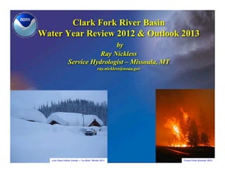
  • 1. Clark Fork River Basin Water Year Review 2012 & Outlook 2013 by Ray Nickless Service Hydrologist – Missoula, MT ray.nickless@noaa.gov Lolo Pass Visitor Center – “La Nina” Winter 2011 Forest Fires Summer 2012
  • 2. Overview • Weather Pattern & Climate (Water Year 2012) • Streamflow volumes (Water Year 2012) • Weather Outlook (Water year 2013)
  • 4. La Nina - Measured 2011-2012 70 Ocean Buoys Weather Balloons
  • 5. La Nina 2011 – 2012 (Wintertime Pattern)
  • 6. Snowpack La Nina Years (Western Montana)
  • 7. Precipitation & Temperature 2012 - Water year
  • 8. Precipitation 2012 – Water Year October 2011 through September 2012
  • 9. New Record Kalispell
  • 10. Tied Record Missoula 41 days without precipitation
  • 11. Dry Butte Entire 2012 water year 68% of ave.
  • 12. New Record Pierce, ID 87 days without precipitation
  • 13. New Record Elk City, ID 32 days without precipitation
  • 14. Temperatures (Warm) Departure from Average Temperature October 2011 through September 2012
  • 15. Drought Lack of precipitation and warmer temperatures
  • 16. Water Supply for Water Year 2012 (A look back)
  • 17. Streamflow Volumes (April through September) Water Year 2012 er Blackfoot Riv 117% of ave. f av ver % o t Ri e. 107 erroo Cl ar 11 k F t 2% ork Bit of Ri av ver e.
  • 18. Streamflow Volumes (April through September) Water Year 2012 N or th Fo 8 rk % 12 Fl of at av he e. ad R iv er M id dl e F 12 ork 4 F Flathead River % la of the 127 % of ave. av ad e. R Hungry Horse Inflow iv er 126 % of ave.
  • 19. Streamflow Volumes (April through September) Water Year 2012 Ko o 14 tena 4% i R Libby Dam Inflow of iver ave 143% of ave. .
  • 20. Precipitation - Temperature Water Supply Forecasts 2013 -Water year
  • 21. Weather Forecast Yesterday
  • 22. Weather Forecast This Week Missoula Snowbowl (Ski Area)
  • 23. Weather Outlook End of October through November 1st Temperature Precipitation
  • 24. El Nino - Watch
  • 25. November-December-January Weather Outlook Temperature Precipitation
  • 26. January-February-March Weather Outlook Temperature Precipitation
  • 27. El Nino & Water Supply Forecasts
  • 28. USGS Streamflow & Annual Departure from mean No rth For kF lath ead Riv er M id dl e Fo rk Fl at he ad Ri ve r
  • 29. Middle Fork Flathead River 19 El Nino years since 1950 & 12 of 19 produced low flows or 63% of time low flows El Nino years El Nino Years El Nino Years
  • 30. USGS Streamflow & Annual Departure from mean er Blackfoot Riv er Riv oot terr Cl ar Bit k Fo rk Ri ve r
  • 31. Blackfoot River 19 El Nino years since 1950 & 13 of 19 produced low flows or 68% of time low flows El Nino years El Nino Years El Nino Years
  • 32. Conclusions – Water Year 2012 • La Nina produced average to above average snowpack in most western MT & north central ID. • Average to above average water supply. • Dry summer. – Water Year 2013 • If El Nino develops (drier winter possible). • If El Nino does not develop (drier, wetter, or average).