
Empfohlen
Weitere ähnliche Inhalte
Was ist angesagt?
Was ist angesagt? (20)
Andere mochten auch
Andere mochten auch (20)
Ähnlich wie Limestone Guide
Ähnlich wie Limestone Guide (20)
Mehr von cheergalsal
Mehr von cheergalsal (20)
Kürzlich hochgeladen
Kürzlich hochgeladen (16)
Limestone Guide
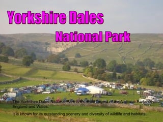
- 1. Yorkshire Dales National Park The Yorkshire Dales National Park is the third largest of the National Parks of England and Wales. It is known for its outstanding scenery and diversity of wildlife and habitats.
- 2. Location Of Yorkshire Dales National Park And Malham
- 3. Limestone Pavement Limestone Pavement Yorkshire Dales Malham Limestone Pavement is a natural landform consisting of a flat land of exposed limestone, that resembles a artificial pavement. Clints. Grykes.
- 4. Swallow Hole A swallow hole is also known as a sink,shake hole. is a natural depression or hole in the surface caused by the removal of soil , by water. Swallowholes may vary in size from less than a meter to several hundred meters both in diameter and depth. They may be formed gradually or suddenly, and are found worldwide.
- 5. Resurgence When a stream disappears it travels underground through a complex series of caves and eventually works its way down to a level of impermeable rock or until it reaches the top of the water table. The stream travels along the surface of the impermeable rock until it reaches the surface as a spring. Where limestone lies on top of impermeable rock along a valley there can be several springs formed along the intersection of the two rocks. This is a resurgence.
- 6. Dry Valley (Watlowes) During the last ice age the limestone was frozen to great depths. When the ice melted it carved out valleys over the frozen rock. When the limestone thawed out the surface water was able to go down through the rocks and the dry valleys were left with no surface water.
- 7. Malham Cove Malham cove is a natural limestone formation.It is the North Yorkshire, England. At the top of the valley there is a curved limestone cliff, also it has a fine limestone pavement at the top.
- 8. Goredale Scar During the last ice age huge ice sheets scraped away the soil covered spurs in many valleys in the Yorkshire Dales. Steep cliffs of bare rock were exposed. Because these scars are more liable to frost shattering and other forms of erosion they usually have scree slopes of broken rock below them.
- 9. Land Use There is plenty of different lad uses in the Yorkshire dales national park. Some of these can be Quarrying, this has been a traditional industry in years. Yorkshire Dales National Park is home to around 19,000 residents in some 7,400 households, mainly in small villages. The largest settlement in the National Park is Sedbergh, with 2,000 people. Enjoyment of the scenery is the top reason people give for visiting the Dales, and walking is a particularly popular activity. There are 1,450km of footpaths and 600km of bridle paths within the National Park and there are plenty of guides and leaflets to help visitors find a walk to suit them. One of the most popular routes is the walk up the Three Peaks; the more adventurous walker may attempt the Pennine Way.
- 10. Land Use 2... The dales also offer a range of activities. mainly outdoor activities. Some of them are caving , climbing, cycling. The Yorkshire dales also get a lot of tourists by the limestone pavement. It is home to a lot of endangered animals, and plants. 40% of land in the Park is enclosed farm land, and farming has been an important part of Dales life for centuries with 35% of jobs in the park relying on farming