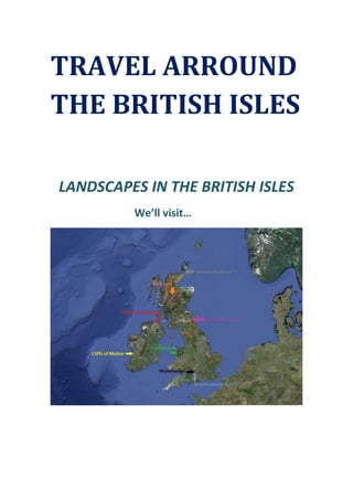
2. CLIFFS OF MOHER
The Cliffs of Moher (Irish: Aillte an Mhothair) are located at the southwestern edge of
the Burren region in County Clare, Ireland.They rise 120 meters above the Atlantic Ocean at
3. Hag's Head, and reach their maximum height of 214 meters just north of O'Brien's Tower,
eight kilometers to the north. The cliffs are one of the most popular tourist destinations in
Ireland and topped the list of attractions in 2006 receive almost one million visitors.
O'Brien's Tower is a round stone tower near the midpoint of the cliffs built in 1835 by
Sir Cornelius O'Brien to impress female visitors. From the cliffs and from atop the watchtower,
visitors can see the Aran Islands in Galway Bay, the Maumturks and Twelve Pins mountain
ranges to the north in County Galway, and Loop Head to the south.
The cliffs take their name from an old fort called Moher that once stood on Hag's
Head, the southernmost point of the cliffs. The writer Thomas Johnson Westropp referred to it
in 1905 as Moher Uí Ruis or Moher Uí Ruidhin. The fort still stood in 1780 and is mentioned in
an account from John Lloyd's a Short Tour Of Clare (1780). It was demolished in 1808 to
provide material for a new telegraph tower. The present tower near the site of the old Moher
Uí Ruidhin was built as a lookout tower during the Napoleonic wars.
4. The facility features interactive media displays which explore topics such as the origin
of the cliffs in local and global geological contexts, and the bird and fish life in the area. A large-
screen multimedia display allows visitors to experience a bird's eye view from the cliffs, as well
as seeing the inside of underwater caves below them. Ferry trips also allow tourists to view the
cliffs from sea level.
7. The Giant's Causeway (known as Clochán an Aifir or Clochán na bhFomhórach in Irish
and the Giant's Causey in Ulster-Scots) is an area of about 40,000 interlocking basalt columns,
result of an ancient volcanic eruption.
It is located in County Antrim on the northeast coast of Northern Ireland, about 4.8 km
northeast of the town of Bushmills. It was declared a World Heritage Site by UNESCO in 1986,
and a National Nature Reserve in 1987 by the Department of the Environment for Northern
Ireland. In a 2005 poll of Radio Times readers, the Giant's Causeway was named as the fourth
greatest natural wonder in the United Kingdom. The tops of the columns form stepping stones
that lead from the cliff foot and disappear under the sea. Most of the columns are hexagonal,
although there are also some with four, five, seven or eight sides. The tallest are about 12
meters high, and the solidified lava in the cliffs is 28 meters thick in places.
8. The Giant's Causeway is today owned and managed by the National Trust and it is the
most popular tourist attraction in Northern Ireland.
11. Snowdonia (Welsh: Eryri) is a region in north Wales and a national park of 2,142 km2 in
area. It was the first to be designated of the three National Parks in Wales, in 1951.
The English name for the area derives from Snowdon, which is the highest mountain in
Wales at 1,085 m. One assumption is that the name is derived from eryr "eagle", but others
state that it means quite simply Highlands, as leading Welsh scholar Sir Ifor Williams proved. In
the middle Ages the title Prince of Wales and Lord of Snowdonia (Tywysog Cymru ac Arglwydd
Eryri) was used by Llywelyn ap Gruffudd; his grandfather Llywelyn Fawr used the title Prince of
north Wales and Lord of Snowdonia.
12. Prior to the designation of the boundaries of the National Park, the term "Snowdonia"
was generally used to refer to a much smaller area, namely the upland area of northern
Gwynedd centred on the Snowdon massif, whereas the national park covers an area more
than twice that size extending far to the south into Meirionnydd.
Within in the park live over 26,000 people. It attracts millions of visitors each year. It is
the third most visited park in England and Wales. On the grounds of the park an important part
of the land is devoted to agriculture. After an administrative reorganization in 1998, the park
extends into the county of Gwynedd and Conwy neighborhood. It is governed by a committee
of 18 members, 9 of whom are elected by Gwynedd, 3 by Conwy, and the remaining 6 for her
Welsh parliament. Curiously, within your field is excluded a small central extension, which
corresponds to the town of Blaenau Ffestiniog and slate quarry. This area was excluded
deliberately to encourage the development of light industry following the closure of the
quarries.
15. Loch Ness (Gaelic: Loch Nis) is a large, deep, freshwater loch in the Scottish Highlands
extending for approximately 37 km southwest of Inverness. Its surface is 15.8 m above sea
level. Loch Ness is best known for alleged sightings of the cryptozoological Loch Ness Monster,
also known affectionately as "Nessie".
16. It is connected at the southern end by the River Oich and a section of the Caledonian
Canal to Loch Oich. At the northern end there is the Bona Narrows which opens out into Loch
Dochfour, which feeds the River Ness and a further section of canal to Inverness. It is one of a
series of interconnected, murky bodies of water in Scotland; its water visibility is exceptionally
low due to a high peat content in the surrounding soil. Is the second largest Scottish loch by
surface area at 56.4 km2 after Loch Lomond. It contains more fresh water than all the lakes in
England and Wales combined.
Boat cruises operate from various locations on the loch shore, giving visitors the
chance to look for the "monster".The Urquhart Castle is located on the Western shore 1.6 km
east of Drumnadrochit. Lighthouses are located at Lochend (Bona Lighthouse) and Fort
Augustus.In its southwestern part, near Fort Augustus, you can see the only island in the lake.
The Cherry Island is an example of Crannog (artificial islands usually dating back to the Iron
Age).
19. Hadrian's Wall (Latin: Vallum Aelium, "Aelian Wall") was a defensive fortification in
Roman Britain. Begun in AD 122, during the rule of emperor Hadrian, it was the first of two
fortifications built across Great Britain, the second being the Antonine Wall, lesser known of
the two because its physical remains are less evident today. Hadrian's Wall was 73 miles long
its width and height were dependent on the construction materials which were available
nearby. East of River Irthing, the wall was made from squared stone and measured 3 meters
wide and five to six meters high, while west of the river the wall was made from turf and
measured 6 meters wide and 3.5 meters high. This does not include the wall's ditches, berms
and forts. The central section measured eight Roman feet wide 2.4 m on a 3 m base. Some
parts of this section of the wall survive to a height of 3 m.
20. The wall was the most heavily fortified border in the Empire. In addition to its role as a
military fortification, it is thought that many of the gates through the wall would have served
as customs posts to allow trade and levy taxation. A significant portion of the wall still exists,
having been rescued in the 19th century by John Clayton, who, alarmed at the destruction by
quarrying, bought a number of sections. For much of its length, the wall can be followed on
foot by Hadrian's Wall Path or by cycle on National Cycle Route 72.
It is the most popular tourist attraction in Northern England. It was made a UNESCO
World Heritage Site in 1987. English Heritage, a government organization in charge of
managing the historic environment of England, describes it as "the most important monument
built by the Romans in Britain"
21. Bournemouth beach
Bournemouth is a large coastal resort town in the ceremonial county of Dorset,
England. Founded in 1810 by Lewis Tregonwell, Bournemouth's growth accelerated with the
arrival of the railway, becoming a recognized town in 1870. Historically part of Hampshire, it
22. joined Dorset with the reorganization of local government in 1974. Since 1997, the town has
been administered by a unitary authority, giving it autonomy from Dorset County Council. The
local authority is Bournemouth Borough Council.
Bournemouth's location on the south coast of England has made it a popular
destination for tourists. The town is a regional centre of business, home of the Bournemouth
International Centre and financial companies that include Liverpool Victoria and PruHealth. In
a 2007 survey by First Direct, Bournemouth was found to be the happiest place in the UK, with
82% of people questioned saying they were happy with their lives.
23. Bournemouth Pier is one of the town's most distinctive landmarks. The first pier was a
simple, wooden jetty that was constructed in 1856. The jetty was replaced by a longer,
wooden pier five years later, and a cast iron structure was built in 1880, costing almost
£22,000. In 1909, Bournemouth Pier was extended to 305 meters. After World War II, the
structure was strengthened to allow for the addition of the Pier Theatre and in 1979, a
redevelopment programme, costing over £1.7 million, saw a great deal of reconstruction work,
and more recently, the Pier has seen the addition of a restaurant.
The Bournemouth Eye is a helium-filled balloon attached to a steel cable. The spherical
balloon is attached to an enclosed gondola that carries up to 30 passengers. Tethered by a
high tensile steel cable, the passenger gondola rises to a height of 120 m, the maximum height
allowed by the Civil Aviation Authority. This provides a panoramic view of the surrounding
area.
24. STONEHENGE
Stonehenge is a prehistoric monument in Wiltshire, England, about 3.2 km west of
Amesbury and 13 km north of Salisbury. One of the most famous sites in the world,
Stonehenge is the remains of a ring of standing stones set within earthworks. It is in the middle
25. of the most dense complex of Neolithic and Bronze Age monuments in England, including
several hundred burial mounds. Archaeologists believe it was built anywhere from 3000 BC to
2000 BC. Radiocarbon dating in 2008 suggested that the first stones were raised between 2400
and 2200 BC, whilst another theory suggests that bluestones may have been raised at the site
as early as 3000 BC.
The surrounding circular earth bank and ditch, which constitute the earliest phase of
the monument, have been dated to about 3100 BC. The site and its surroundings were added
to the UNESCO's list of World Heritage Sites in 1986 in a co-listing with Avebury Henge. It is a
national legally protected Scheduled Ancient Monument. Stonehenge is owned by the Crown
and managed by English Heritage, while the surrounding land is owned by the National Trust.
26. Archaeological evidence found by the Stonehenge Riverside Project in 2008 indicates
that Stonehenge could have been a burial ground from its earliest beginnings. The dating of
cremated remains found on the site indicate that deposits contain human bone from as early
as 3000 BC, when the ditch and bank were first dug. Such deposits continued at Stonehenge
for at least another 500 years.The site is a place of religious significance and pilgrimage in Neo-
Druidry.
27. DUNCANSBY HEAD
Duncansby Head (Gaelic: Rubha Duncansby) is the most north-easterly part of the
Scottish mainland, including even the famous John o' Groats, Caithness, Highland. The
headland juts into the North Sea, with the Pentland Firth to its north and west and the Moray
28. Firth to its south. The point is marked by Duncansby Head Lighthouse. The Duncansby Head
Site of Special Scientific Interest includes the 6.5 km stretch of coast south to Skirza Head. It
includes the Duncansby Stacks, prominent sea stacks just off the coast.
Duncansby Head is the real north eastern tip of the Scottish mainland, and probably
exceeds John o' Groat's distance from Lands End. While John o' Groats is an increasingly
successful commercial tourist attraction, Duncansby Head reveals nature at its most striking.
Many visitors will call it a day once they have admired the superb view north from the car
park, get back into their cars, and return to John o' Groats. Which is a shame, because
Duncansby Head's real delights lie to the south not to the north, and require a short walk over
the highest part of the surrounding landscape, behind the lighthouse.
29. Across the clifftop fields and you come to the day's highlight, the stunning view south
to Thirle Door and the Stacks of Duncansby. The first is a rocky arch, the second a group of
large jagged sea stacks. This is a spot you will want to savour, with a view that varies as you
move along the clifftop path and bring into play different alignments of the stacks and arch.
Duncansby Head is certainly a must-see for anyone who likes their scenery both natural.
30. I hope will be helpful, to enjoy the most of the UK and Ireland. Best regards.