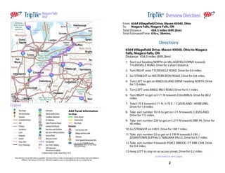
2. TripTik® Overview Directions Map
1 TripTik® Maps & Turn by Turn Directions
(continued from previous page)
14. Go STRAIGHT on PEACE BRIDGE PLAZA. Drive for 0.1 miles.
15. Go STRAIGHT on PEACE BRIDGE. Drive for 0.2 miles.
16. You are leaving the United States and entering Canada. Drive for
0.4 miles.
17. PEACE BRIDGE becomes QEW. Drive for 9.2 miles.
18. Take exit number 16 to get on RR116 N towards SODOM ROAD
/ CHIPPAWA. Drive for 0.5 miles.
19. Keep RIGHT to stay on RR116 N. Drive for 4 miles.
20. Turn RIGHT onto MAIN STREET. Drive for 0.6 miles.
21. Turn LEFT onto CUMMINGTON SQUARE W. Drive for a short
distance.
22. CUMMINGTON SQUARE W becomes PORTAGE ROAD. Drive for 0.1
miles.
23. Turn RIGHT onto MACKLEM STREET. Drive for 0.2 miles.
24. Go STRAIGHT on NIAGARA PARKWAY. Drive for 2.1 miles.
25. You have reached Niagara Falls, Niagara Falls, ON 1000 ft
500 m
Directions
6564 Villagefield Drive, Mason 45040, Ohio to
Niagara Falls, Niagara Falls, ON
Distance: 434.5 miles (699.2km)
Traveled on This Map: 1.3 miles (2.1km)
1. Start out heading NORTH on VILLAGEFIELD DRIVE towards
TYLERSVILLE ROAD. Drive for a short distance.
2. Turn RIGHT onto TYLERSVILLE ROAD. Drive for 0.6 miles.
3. Go STRAIGHT on WESTERN ROW ROAD. Drive for 0.8 miles.
3 4
3. TripTik® Maps & Turn by Turn Directions Map
2
Map
3 TripTik® Maps & Turn by Turn Directions
1000 ft 0.5 mi
500 m 500 m
Directions Directions
Continuing to Niagara Falls, Niagara Falls, ON Continuing to Niagara Falls, Niagara Falls, ON
Remaining Distance: 433.2 miles (697.1km) Remaining Distance: 431.9 miles (695.1km)
Traveled on This Map: 1.3 miles (2.1km) Traveled on This Map: 1.7 miles (2.7km)
4. Turn LEFT to get on KINGS ISLAND DRIVE heading NORTH. Drive 5. Turn LEFT onto KINGS MILS ROAD. Drive for 0.1 miles.
for 1.9 miles.
6. Turn RIGHT to get on I71 N towards COLUMBUS. Drive for 80.2
miles.
5 6
4. TripTik® Maps & Turn by Turn Directions Map
4
Map
5 TripTik® Maps & Turn by Turn Directions
10 mi 5 mi
20 km 10 km
Directions Directions
Continuing to Niagara Falls, Niagara Falls, ON Continuing to Niagara Falls, Niagara Falls, ON
Remaining Distance: 430.3 miles (692.5km) Remaining Distance: 355.2 miles (571.6km)
Traveled on This Map: 75.0 miles (120.7km) Traveled on This Map: 35.4 miles (57.0km)
6a. Continue on I71 N. 7. Take I70 E towards I71 N / I70 E / CLEVELAND / WHEELING.
Drive for 1.8 miles.
Construction Info 8. Take exit number 101A to get on I71 N towards CLEVELAND.
» Construction/delays possible: I71; between just north of Drive for 112 miles.
SR380 and SR72 (exit 58)
Advisory
» Expect delays during morning and afternoon rush hours:
I70 at US23 Interchange
» Expect delays during morning and afternoon rush hours:
I71 at I70 interchange
7 8
5. TripTik® Maps & Turn by Turn Directions Map
6
Map
7 TripTik® Maps & Turn by Turn Directions
10 mi 10 mi
20 km 20 km
Directions Directions
Continuing to Niagara Falls, Niagara Falls, ON Continuing to Niagara Falls, Niagara Falls, ON
Remaining Distance: 319.9 miles (514.8km) Remaining Distance: 228.2 miles (367.2km)
Traveled on This Map: 91.6 miles (147.4km) Traveled on This Map: 90.5 miles (145.6km)
9. Take exit number 220 to get on I271 N towards ERIE PA. Drive for 10. Go STRAIGHT on I90 E. Drive for 169.7 miles.
40 miles.
Construction Info
Construction Info » Construction/delays possible: I271; Twin bridges over the
» Construction/delays possible: I71; just south of the Wayne Cuyahoga Valley National Park
county line, between mile marker 194 and 195 » Construction/delays possible: I90; from SR608 to SR528
» Construction/delays likely: I71; between Leroy Rd and just
north of I76 (continued on next page)
9 10
6. TripTik® Maps & Turn by Turn Directions Map
8 TripTik® Maps & Turn by Turn Directions
(continued from previous page)
Advisory
» Expect delays during morning and afternoon rush hours:
I271 at I77 interchange
» Expect delays during summer weekends: I271 @ SR8
Interchange (Macedonia)
» Expect delays during morning and afternoon rush hours:
I480 between SR14 and I271, I480 and I271 Interchange
» Expect delays during morning and afternoon rush hours:
I90 between SR44 and SR91
10 mi
20 km
See detailed TripTik Scenic Information after the last Map/Directions page
Directions
Continuing to Niagara Falls, Niagara Falls, ON
Remaining Distance: 137.7 miles (221.6km)
Traveled on This Map: 71.9 miles (115.7km)
10a.Continue on I90 E.
11 12
7. TripTik® Maps & Turn by Turn Directions Map
9
Map
10 TripTik® Maps & Turn by Turn Directions
5 mi 0.5 mi
10 km 500 m
Directions Directions
Continuing to Niagara Falls, Niagara Falls, ON Continuing to Niagara Falls, Niagara Falls, ON
Remaining Distance: 65.8 miles (105.9km) Remaining Distance: 18.3 miles (29.5km)
Traveled on This Map: 47.5 miles (76.4km) Traveled on This Map: 1.5 miles (2.4km)
11. Take exit number 53 to get on I190 N towards I190 / 12. Take exit number 9 towards PEACE BRIDGE / FT ERIE CAN. Drive
DOWNTOWN BUFFALO / NIAGARA FALLS. Drive for 6.7 miles. for 0.4 miles.
Advisory 13. Keep LEFT to stay on an access street. Drive for 0.2 miles.
» Expect delays during morning and afternoon rush hours: 14. Go STRAIGHT on PEACE BRIDGE PLAZA. Drive for 0.1 miles.
I90 between exit 50 and exit 54.
15. Go STRAIGHT on PEACE BRIDGE. Drive for 0.2 miles.
16. You are leaving the United States and entering Canada. Drive for
0.4 miles.
17. PEACE BRIDGE becomes QEW. Drive for 9.2 miles.
13 14
8. TripTik® Maps & Turn by Turn Directions Map
11 TripTik® Maps & Turn by Turn Directions
(continued from previous page)
Bridge and Ferry
» Buffalo, NYFort Erie, ON: The Peace Bridge. No toll
eastbound. Car, pickupcamper, motorcycle, trailers $3 (US),
$3.75 (CAN). Hazardous material requires written 48 hr
advance notice. Discount given for EZ Pass users.
Advisory
» As of 6/1/09, proof of citizenship is required to enter Canada.
A passport booklet/card, enhanced driver's license or Trusted
Traveler program card is required to enter the U.S. by land/
sea. Passport required to enter either country by air.
» Expect delays due to toll collection rush hours: Peace Bridge,
the Fort Erie, ON. and Buffalo, NY border crossing.
» As of 6/1/09, proof of citizenship is required to enter Canada.
A passport booklet/card, enhanced driver's license or Trusted
Traveler program card is required to enter the U.S. by land/
sea. Passport required to enter either country by air.
2 mi
2 km
Directions
Continuing to Niagara Falls, Niagara Falls, ON
Remaining Distance: 16.8 miles (27.0km)
Traveled on This Map: 9.1 miles (14.6km)
17a.Continue on QEW.
15 16
9. TripTik® Maps & Turn by Turn Directions Map
12
Map
13 TripTik® Maps & Turn by Turn Directions
1000 ft 0.5 mi
500 m 500 m
Directions Directions
Continuing to Niagara Falls, Niagara Falls, ON Continuing to Niagara Falls, Niagara Falls, ON
Remaining Distance: 7.7 miles (12.4km) Remaining Distance: 6.7 miles (10.8km)
Traveled on This Map: 1.0 miles (1.6km) Traveled on This Map: 1.8 miles (2.9km)
18. Take exit number 16 to get on RR116 N towards SODOM ROAD 19a.Continue on RR116 N.
/ CHIPPAWA. Drive for 0.5 miles.
19. Keep RIGHT to stay on RR116 N. Drive for 4 miles.
17 18
10. TripTik® Maps & Turn by Turn Directions Map
14
Map
15 TripTik® Maps & Turn by Turn Directions
0.5 mi 0.5 mi
500 m 500 m
See detailed TripTik Scenic Information after the last Map/Directions page
Directions Directions
Continuing to Niagara Falls, Niagara Falls, ON Continuing to Niagara Falls, Niagara Falls, ON
Remaining Distance: 4.9 miles (7.9km) Remaining Distance: 3.1 miles (5.0km)
Traveled on This Map: 1.8 miles (2.9km) Traveled on This Map: 1.3 miles (2.1km)
19b.Continue on RR116 N. 20. Turn RIGHT onto MAIN STREET. Drive for 0.6 miles.
21. Turn LEFT onto CUMMINGTON SQUARE W. Drive for a short
distance.
22. CUMMINGTON SQUARE W becomes PORTAGE ROAD. Drive for 0.1
miles.
23. Turn RIGHT onto MACKLEM STREET. Drive for 0.2 miles.
24. Go STRAIGHT on NIAGARA PARKWAY. Drive for 2.1 miles.
19 20
11. TripTik® Maps & Turn by Turn Directions Map
16 TripTik® Scenic Information
Map
8
New York Thruway
Location:
Pennsylvania border to Exit 59/Dunkirk
Description:
Neat rows of vineyards stripe the hilly terrain of the grape belt. The location near the
shores of Lake Erie creates favorable conditions for grape and apple orchards. Stop by
the town of Dunkirk for a historical look at the Dunkirk Historical Lighthouse and
Veterans Park Museum. At the harbor, take a picture of the ships bobbing in the deep
waters.
Map
8
I90
Location:
SR 89/Exit 41 to New York border
Description:
Over 40,000 acres of vineyards drape the area with neat rows of green vines, and in
season luscious green and purple grapes. The Chatauqua wine country is popular for
its wine and grape juice due to rich soil and moderating effects of Lake Erie. Behind the
hills and pastures, Lake Erie stretches out for miles, creating a picturesque scene.
Map Map
15 16
0.5 mi Niagara River Parkway
500 m
Location:
See detailed TripTik Scenic Information after the last Map/Directions page
Fort Erie to NiagaraOnTheLake
Description:
Directions The Niagra River connects Canada to the United States as it rushes to the phenomenal
Continuing to Niagara Falls, Niagara Falls, ON Niagra Falls. Historic Fort Erie and Fort George provide a look into the country's past,
Remaining Distance: 1.9 miles (3.1km) and the cities lining the route are filled with attractions and recreation opportunities.
The main event is the beautiful, powerful phenomena of Niagra Falls. Photograph the
Traveled on This Map: 1.9 miles (3.1km) soft mist rising from the horseshoeshaped falls for a record of the remarkable
tumbling waters.
25. You have reached Niagara Falls, Niagara Falls, ON
21 22