SlideShare ist ein Scribd-Unternehmen logo
1 von 1
FONDAZIONE PER IL CLIMA E LA SOSTENIBILITA’


                              Spatial time series breakpoint and coherency analysis of
                                 climate-vegetation relationship in eastern Africa
                               Crisci A.1, Grasso V. 1,Capecchi V. 1,Genesio L.1, Bacci M.1, Tarchiani V.1,Di Vecchia A.1 and Vignaroli P.2
                                         1 National Research Council of Italy - Istitute of Biometeorology (CNR-IBIMET) ; 2 Climate and Sustainability Foundation (FCS)


                                                  Introduction                                                                                                         Results
        Food security in East Africa region essentially depends on the                                       Focusing on Ethiopia country, where agriculture sector accounts for
                                                                                                             47% of the GDP, provides 85% of employment and 90% of foreign
        stability of rain-fed crops farming, which renders its society
                                                                                                             currency earning, some preliminary results obtained using this
        vulnerable to climatic fluctuations. These ones in Africa are                                        methodology are shown.
        most widely and directly related to rainfall. The CPSZ2 project is                                                 Legend

        an initiative of Joint Research Centre of European Union to                                                             Eth_g2

                                                                                                                           Time Series Analysis


        upgrade ad modernize the Crop Production System Zones                                                              Priority MUs
                                                                                                                                No changes


        Database of the IGAD Region (CPSZ). The CPSZ database,                                                                  Low
                                                                                                                                Medium


        realized by FAO and co-funded by the Italian Cooperation is a
                                                                                                                                High


        unique information system for the agricultural monitoring and
        early warning activities on the seven countries of the Horn of
        Africa: Djibouti, Eritrea, Ethiopia, Kenya, Sudan, Somalia and
        Uganda.


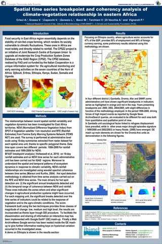
                                                                                                              In four different district ( Gambella, Oromia, Afar and SNNP) some
                                                                                                              administrative unit have shown significant breakpoints in indicators
                                                                                                              series as highlighted in orange and red in the map. Years presenting
                                                                                                              breakpoints are: 2000, 2002, 2004/2005, with slight differences in
                 IGAD NDVI climatology          IGAD Potential Evapotraspiration IGAD Length of season map    function of the methodology employed. In the period 1999-2009, driving
                                                                                                              forces of high impact events as reported by Google News
                                                    Methods                                                   ArchiveSearch queries, are evaluated to be different for each area both
        The relationships between recent spatial rainfall variability and                                     from quantitative and qualitative point of view.
        vegetation dynamics has been investigated for East Africa                                             In Gambella unit sociological factor linked to refugees displacement
        territories. NDVI (Normalized Difference Vegetation Index) from                                       have prevailed, while in other areas major drought episodes signature
                                                                                                              ( 1999/2000 and 2002/2003) or heavy floods (2006) have emerged. GE
        SPOT-4 Vegetation satellite 1 km resolution and RFE (Rainfall
                                                                                                              mash–up main elements are shown for the Oromia-Arsi units as
        Estimates) from Famine Early Warning Systems Network (FEWS
                                                                                                              demonstration in the following figures.
        NET) are used. The survey is performed at administrative level
                                                                                                                                       Oromia Arsi
        scale using 10-day summaries extracted from raster dataset for
                                                                                                             BFAST breakpoints analisys NDVI
        each spatial area unit, thanks to specific polygonal theme. Data
        time span covers two different periods: 1996-2009 for rainfall
        estimates and 1999-2009 for NDVI.
        BFAST breakpoint analysis ( Verbesselt et al, 2010) on 10-day
        rainfall estimates and on NDVI time series for each administrative
        unit has been carried out for IGAD regions. Moreover to
        understand the spatial and temporal patterns of ecosystem                                            BFAST breakpoints analisys rainfall
        dynamics in response to climatic variability, NDVI–rainfall
        relationships are investigated using wavelet spectral coherence
        between time series (Maraun and Kurths, 2004) . Hot spot detection
        methodology is obtained from time series analysis carried out on
        the RFE and NDVI time series. The main drivers for hot spot
        detection are: (i) the significant annual breakpoints detected and
        (ii) the temporal range of coherence between NDVI and rainfall.
        These ones indicates the zones where and when significant
        changes in agricultural production systems might have occurred.
        For each mapping unit, the significant breaks detected over the
                                                                                                             Google News ArchiveSearch
        time series of indicators could be related to the response of                                        1999-2009 annual frequency                        NDVI-rainfall time series                    NDVI-rainfall time series
                                                                                                                                                               wavelets coherency
        vegetation and to the agro-climatic conditions. The score                                            reports                                                                                        wavelets phase

        framework built using the two techniques provides three classes of
        magnitude of change: low, medium and high level; the results are                                                                                           References
        incorporated as theme layer trough GIS procedure. To facilitate the                                  Google ArchiveSearch 2009 http://news.google.com/archivesearch/advanced_search
                                                                                                             Verbesselt J., Rob Hyndman R., Zeileis A., Culvenor D, Phenological change detection while accounting for abrupt and gradual trends in
        dissemination and sharing of information an interactive map has                                      satellite image time series, 2010, Remote Sensing of Environment, Volume 114, Issue 12, ISSN 0034-4257,
                                                                                                             DOI:10.1016/j.rse.2010.08.003.
        been implemented with Google Earth® (GE) mash-up. Finally a Web                                      Maraun, D., & Kurths, J. 2004, Nonlinear Process. in Geophys., 11, 505

        ArchiveNews Google service has been nested inside the GE mash-
                                                                                                                                                                      Contacts
        up to give further informative reading keys on hystorical variation
        occurred in the investigated areas.                                                                                                       www.ibimet.cnr.it
                                                                                                                                                  Africa projects & initiatives:          Patrizio Vignaroli, p.vignaroli@ibimet.cnr.it
        A demo on Ethiopia is shown in the results section                                                                                                                                Lorenzo Genesio, l.genesio@ibimet.cnr.it
                                                                                                                                                  Statistical Methodology:                Alfonso Crisci, a.crisci@ibimet.cnr.it
                                                                                                                                                  Communication:                          Valentina Grasso, vgrasso@ibimet.cnr.it

TEMPLATE DESIGN © 2008

www.PosterPresentations.com

Weitere ähnliche Inhalte

Was ist angesagt?

Soil mapping goes digital - the GlobalSoilMap experience by Alex. McBratney
Soil mapping goes digital - the GlobalSoilMap experience by Alex. McBratneySoil mapping goes digital - the GlobalSoilMap experience by Alex. McBratney
Soil mapping goes digital - the GlobalSoilMap experience by Alex. McBratneyFAO
 
Carla Ximena SALINAS "Numerical model to assess the impact of the strategies ...
Carla Ximena SALINAS "Numerical model to assess the impact of the strategies ...Carla Ximena SALINAS "Numerical model to assess the impact of the strategies ...
Carla Ximena SALINAS "Numerical model to assess the impact of the strategies ...Global Risk Forum GRFDavos
 
THE IMPORTANCE OF SAMPLING FOR THE EFFICIENCY OF ARTIFICIAL NEURAL NETWORKS I...
THE IMPORTANCE OF SAMPLING FOR THE EFFICIENCY OF ARTIFICIAL NEURAL NETWORKS I...THE IMPORTANCE OF SAMPLING FOR THE EFFICIENCY OF ARTIFICIAL NEURAL NETWORKS I...
THE IMPORTANCE OF SAMPLING FOR THE EFFICIENCY OF ARTIFICIAL NEURAL NETWORKS I...Ricardo Brasil
 
IRJET- Classification of Agricultural Land’s Capability
IRJET-  	  Classification of Agricultural Land’s CapabilityIRJET-  	  Classification of Agricultural Land’s Capability
IRJET- Classification of Agricultural Land’s CapabilityIRJET Journal
 
LANDSLIDE HAZARD ZONATION MAPPING USING RS AND GIS
LANDSLIDE HAZARD ZONATION MAPPING USING RS AND GISLANDSLIDE HAZARD ZONATION MAPPING USING RS AND GIS
LANDSLIDE HAZARD ZONATION MAPPING USING RS AND GISAditya Ghumare
 
Aan with gis in rasuwa
Aan with gis in rasuwaAan with gis in rasuwa
Aan with gis in rasuwaDPNet
 
OnTheUseOfMultitemporalSeriesOfCOSMODataForClassificationAndSurfaceParameterR...
OnTheUseOfMultitemporalSeriesOfCOSMODataForClassificationAndSurfaceParameterR...OnTheUseOfMultitemporalSeriesOfCOSMODataForClassificationAndSurfaceParameterR...
OnTheUseOfMultitemporalSeriesOfCOSMODataForClassificationAndSurfaceParameterR...grssieee
 
GIS LANDSLIDES ANALYSIS ii
GIS LANDSLIDES ANALYSIS iiGIS LANDSLIDES ANALYSIS ii
GIS LANDSLIDES ANALYSIS iiEdmundo Zevallos
 
Predicting and mapping soil properties using proximal/remote sensing by Zhou ...
Predicting and mapping soil properties using proximal/remote sensing by Zhou ...Predicting and mapping soil properties using proximal/remote sensing by Zhou ...
Predicting and mapping soil properties using proximal/remote sensing by Zhou ...FAO
 
Operational Remote sensing Applications
Operational Remote sensing ApplicationsOperational Remote sensing Applications
Operational Remote sensing ApplicationsTushar Dholakia
 
Applications of Remote Sensing
Applications of Remote SensingApplications of Remote Sensing
Applications of Remote SensingAbhiram Kanigolla
 
Applied Geospatial Sciences Assignment
Applied Geospatial Sciences AssignmentApplied Geospatial Sciences Assignment
Applied Geospatial Sciences AssignmentJoshua Brunsdon
 
4. empirical approaches in eld assessments (a)
4. empirical approaches in eld assessments (a)4. empirical approaches in eld assessments (a)
4. empirical approaches in eld assessments (a)LandDegradation
 
The Harmonized World Soil Database (HWSD), A Global Soil Information System, ...
The Harmonized World Soil Database (HWSD), A Global Soil Information System, ...The Harmonized World Soil Database (HWSD), A Global Soil Information System, ...
The Harmonized World Soil Database (HWSD), A Global Soil Information System, ...FAO
 
Part_III_remotesensing-02-00076 (8)
Part_III_remotesensing-02-00076 (8)Part_III_remotesensing-02-00076 (8)
Part_III_remotesensing-02-00076 (8)Heikki Laurila
 
505659main npp pressbriefing_slides_mli
505659main npp pressbriefing_slides_mli505659main npp pressbriefing_slides_mli
505659main npp pressbriefing_slides_mlithedigger
 
ESTIMATION OF SOIL ERODIBILITY AND RAINFALL EROSIVITY FOR THE BIEMSO BASIN, G...
ESTIMATION OF SOIL ERODIBILITY AND RAINFALL EROSIVITY FOR THE BIEMSO BASIN, G...ESTIMATION OF SOIL ERODIBILITY AND RAINFALL EROSIVITY FOR THE BIEMSO BASIN, G...
ESTIMATION OF SOIL ERODIBILITY AND RAINFALL EROSIVITY FOR THE BIEMSO BASIN, G...Eric Takyi Atakora , Ph.D (candidate)
 

Was ist angesagt? (20)

Soil mapping goes digital - the GlobalSoilMap experience by Alex. McBratney
Soil mapping goes digital - the GlobalSoilMap experience by Alex. McBratneySoil mapping goes digital - the GlobalSoilMap experience by Alex. McBratney
Soil mapping goes digital - the GlobalSoilMap experience by Alex. McBratney
 
Carla Ximena SALINAS "Numerical model to assess the impact of the strategies ...
Carla Ximena SALINAS "Numerical model to assess the impact of the strategies ...Carla Ximena SALINAS "Numerical model to assess the impact of the strategies ...
Carla Ximena SALINAS "Numerical model to assess the impact of the strategies ...
 
THE IMPORTANCE OF SAMPLING FOR THE EFFICIENCY OF ARTIFICIAL NEURAL NETWORKS I...
THE IMPORTANCE OF SAMPLING FOR THE EFFICIENCY OF ARTIFICIAL NEURAL NETWORKS I...THE IMPORTANCE OF SAMPLING FOR THE EFFICIENCY OF ARTIFICIAL NEURAL NETWORKS I...
THE IMPORTANCE OF SAMPLING FOR THE EFFICIENCY OF ARTIFICIAL NEURAL NETWORKS I...
 
IRJET- Classification of Agricultural Land’s Capability
IRJET-  	  Classification of Agricultural Land’s CapabilityIRJET-  	  Classification of Agricultural Land’s Capability
IRJET- Classification of Agricultural Land’s Capability
 
LANDSLIDE HAZARD ZONATION MAPPING USING RS AND GIS
LANDSLIDE HAZARD ZONATION MAPPING USING RS AND GISLANDSLIDE HAZARD ZONATION MAPPING USING RS AND GIS
LANDSLIDE HAZARD ZONATION MAPPING USING RS AND GIS
 
Aan with gis in rasuwa
Aan with gis in rasuwaAan with gis in rasuwa
Aan with gis in rasuwa
 
OnTheUseOfMultitemporalSeriesOfCOSMODataForClassificationAndSurfaceParameterR...
OnTheUseOfMultitemporalSeriesOfCOSMODataForClassificationAndSurfaceParameterR...OnTheUseOfMultitemporalSeriesOfCOSMODataForClassificationAndSurfaceParameterR...
OnTheUseOfMultitemporalSeriesOfCOSMODataForClassificationAndSurfaceParameterR...
 
GIS LANDSLIDES ANALYSIS ii
GIS LANDSLIDES ANALYSIS iiGIS LANDSLIDES ANALYSIS ii
GIS LANDSLIDES ANALYSIS ii
 
Predicting and mapping soil properties using proximal/remote sensing by Zhou ...
Predicting and mapping soil properties using proximal/remote sensing by Zhou ...Predicting and mapping soil properties using proximal/remote sensing by Zhou ...
Predicting and mapping soil properties using proximal/remote sensing by Zhou ...
 
Operational Remote sensing Applications
Operational Remote sensing ApplicationsOperational Remote sensing Applications
Operational Remote sensing Applications
 
FINAL REPORT
FINAL REPORTFINAL REPORT
FINAL REPORT
 
Applications of Remote Sensing
Applications of Remote SensingApplications of Remote Sensing
Applications of Remote Sensing
 
Cn 9 wed13_all_wb5_posters
Cn 9 wed13_all_wb5_postersCn 9 wed13_all_wb5_posters
Cn 9 wed13_all_wb5_posters
 
Applied Geospatial Sciences Assignment
Applied Geospatial Sciences AssignmentApplied Geospatial Sciences Assignment
Applied Geospatial Sciences Assignment
 
4. empirical approaches in eld assessments (a)
4. empirical approaches in eld assessments (a)4. empirical approaches in eld assessments (a)
4. empirical approaches in eld assessments (a)
 
The Harmonized World Soil Database (HWSD), A Global Soil Information System, ...
The Harmonized World Soil Database (HWSD), A Global Soil Information System, ...The Harmonized World Soil Database (HWSD), A Global Soil Information System, ...
The Harmonized World Soil Database (HWSD), A Global Soil Information System, ...
 
Grp4 outlook bot april 2011 v2
Grp4 outlook bot april 2011 v2Grp4 outlook bot april 2011 v2
Grp4 outlook bot april 2011 v2
 
Part_III_remotesensing-02-00076 (8)
Part_III_remotesensing-02-00076 (8)Part_III_remotesensing-02-00076 (8)
Part_III_remotesensing-02-00076 (8)
 
505659main npp pressbriefing_slides_mli
505659main npp pressbriefing_slides_mli505659main npp pressbriefing_slides_mli
505659main npp pressbriefing_slides_mli
 
ESTIMATION OF SOIL ERODIBILITY AND RAINFALL EROSIVITY FOR THE BIEMSO BASIN, G...
ESTIMATION OF SOIL ERODIBILITY AND RAINFALL EROSIVITY FOR THE BIEMSO BASIN, G...ESTIMATION OF SOIL ERODIBILITY AND RAINFALL EROSIVITY FOR THE BIEMSO BASIN, G...
ESTIMATION OF SOIL ERODIBILITY AND RAINFALL EROSIVITY FOR THE BIEMSO BASIN, G...
 

Ähnlich wie Spatial time series breakpoint and coherency analisys of climate-vegetation relationship in eastern Africa

Changes_in_vegetation_and_rainfall_patterns_in_subSaharan_Africa_over_the_las...
Changes_in_vegetation_and_rainfall_patterns_in_subSaharan_Africa_over_the_las...Changes_in_vegetation_and_rainfall_patterns_in_subSaharan_Africa_over_the_las...
Changes_in_vegetation_and_rainfall_patterns_in_subSaharan_Africa_over_the_las...grssieee
 
Geostatistical analysis of rainfall variability on the plateau of Allada in S...
Geostatistical analysis of rainfall variability on the plateau of Allada in S...Geostatistical analysis of rainfall variability on the plateau of Allada in S...
Geostatistical analysis of rainfall variability on the plateau of Allada in S...IJERA Editor
 
Assessment of wheat crop coefficient using remote sensing techniques
Assessment of wheat crop coefficient using remote sensing techniquesAssessment of wheat crop coefficient using remote sensing techniques
Assessment of wheat crop coefficient using remote sensing techniquesPremier Publishers
 
Drought monitoring and early warning in the MENA region: The ICBA contributio...
Drought monitoring and early warning in the MENA region: The ICBA contributio...Drought monitoring and early warning in the MENA region: The ICBA contributio...
Drought monitoring and early warning in the MENA region: The ICBA contributio...NENAwaterscarcity
 
Field Windbreak / Living Snow Fence Crop Yield Assessment
Field Windbreak / Living Snow Fence Crop Yield AssessmentField Windbreak / Living Snow Fence Crop Yield Assessment
Field Windbreak / Living Snow Fence Crop Yield Assessmentnacaa
 
Agricultural Drought Severity assessment using land Surface temperature and N...
Agricultural Drought Severity assessment using land Surface temperature and N...Agricultural Drought Severity assessment using land Surface temperature and N...
Agricultural Drought Severity assessment using land Surface temperature and N...John Kapoi Kapoi
 
Remote sensing as landscape inventory tool
Remote sensing as landscape inventory toolRemote sensing as landscape inventory tool
Remote sensing as landscape inventory toolCIFOR-ICRAF
 
Towards Climate Change Resilient of Hail Haor, Sylhet: Reviewing the Role of ...
Towards Climate Change Resilient of Hail Haor, Sylhet: Reviewing the Role of ...Towards Climate Change Resilient of Hail Haor, Sylhet: Reviewing the Role of ...
Towards Climate Change Resilient of Hail Haor, Sylhet: Reviewing the Role of ...IOSR Journals
 
IRJET- Optimum Band Selection in Sentinel-2A Satellite for Crop Classificatio...
IRJET- Optimum Band Selection in Sentinel-2A Satellite for Crop Classificatio...IRJET- Optimum Band Selection in Sentinel-2A Satellite for Crop Classificatio...
IRJET- Optimum Band Selection in Sentinel-2A Satellite for Crop Classificatio...IRJET Journal
 
Mapping of Temporal Variation of Drought using Geospatial Techniques
Mapping of Temporal Variation of Drought using Geospatial TechniquesMapping of Temporal Variation of Drought using Geospatial Techniques
Mapping of Temporal Variation of Drought using Geospatial TechniquesIRJET Journal
 
Assessment of Drought Occurrence in Kano State, Nigeria
Assessment of Drought Occurrence in Kano State, NigeriaAssessment of Drought Occurrence in Kano State, Nigeria
Assessment of Drought Occurrence in Kano State, Nigeriaijtsrd
 
The significance of indigenous weather forecast knowledge and practices under...
The significance of indigenous weather forecast knowledge and practices under...The significance of indigenous weather forecast knowledge and practices under...
The significance of indigenous weather forecast knowledge and practices under...Premier Publishers
 
Geospatial tools to guide targeting of technologies
Geospatial tools to guide targeting of technologiesGeospatial tools to guide targeting of technologies
Geospatial tools to guide targeting of technologiesafrica-rising
 
Agricultural risk micro-insurance product for Mozambique
Agricultural risk micro-insurance product for MozambiqueAgricultural risk micro-insurance product for Mozambique
Agricultural risk micro-insurance product for MozambiqueGlobal Risk Forum GRFDavos
 

Ähnlich wie Spatial time series breakpoint and coherency analisys of climate-vegetation relationship in eastern Africa (20)

Changes_in_vegetation_and_rainfall_patterns_in_subSaharan_Africa_over_the_las...
Changes_in_vegetation_and_rainfall_patterns_in_subSaharan_Africa_over_the_las...Changes_in_vegetation_and_rainfall_patterns_in_subSaharan_Africa_over_the_las...
Changes_in_vegetation_and_rainfall_patterns_in_subSaharan_Africa_over_the_las...
 
Geostatistical analysis of rainfall variability on the plateau of Allada in S...
Geostatistical analysis of rainfall variability on the plateau of Allada in S...Geostatistical analysis of rainfall variability on the plateau of Allada in S...
Geostatistical analysis of rainfall variability on the plateau of Allada in S...
 
Assessment of wheat crop coefficient using remote sensing techniques
Assessment of wheat crop coefficient using remote sensing techniquesAssessment of wheat crop coefficient using remote sensing techniques
Assessment of wheat crop coefficient using remote sensing techniques
 
Drought monitoring and early warning in the MENA region: The ICBA contributio...
Drought monitoring and early warning in the MENA region: The ICBA contributio...Drought monitoring and early warning in the MENA region: The ICBA contributio...
Drought monitoring and early warning in the MENA region: The ICBA contributio...
 
Field Windbreak / Living Snow Fence Crop Yield Assessment
Field Windbreak / Living Snow Fence Crop Yield AssessmentField Windbreak / Living Snow Fence Crop Yield Assessment
Field Windbreak / Living Snow Fence Crop Yield Assessment
 
Agricultural Drought Severity assessment using land Surface temperature and N...
Agricultural Drought Severity assessment using land Surface temperature and N...Agricultural Drought Severity assessment using land Surface temperature and N...
Agricultural Drought Severity assessment using land Surface temperature and N...
 
Remote sensing as landscape inventory tool
Remote sensing as landscape inventory toolRemote sensing as landscape inventory tool
Remote sensing as landscape inventory tool
 
Towards Climate Change Resilient of Hail Haor, Sylhet: Reviewing the Role of ...
Towards Climate Change Resilient of Hail Haor, Sylhet: Reviewing the Role of ...Towards Climate Change Resilient of Hail Haor, Sylhet: Reviewing the Role of ...
Towards Climate Change Resilient of Hail Haor, Sylhet: Reviewing the Role of ...
 
Xu Yinlong — Agricultural risk to climate change in china
Xu Yinlong — Agricultural risk to climate change in chinaXu Yinlong — Agricultural risk to climate change in china
Xu Yinlong — Agricultural risk to climate change in china
 
IRJET- Optimum Band Selection in Sentinel-2A Satellite for Crop Classificatio...
IRJET- Optimum Band Selection in Sentinel-2A Satellite for Crop Classificatio...IRJET- Optimum Band Selection in Sentinel-2A Satellite for Crop Classificatio...
IRJET- Optimum Band Selection in Sentinel-2A Satellite for Crop Classificatio...
 
C05621018
C05621018C05621018
C05621018
 
Mapping of Temporal Variation of Drought using Geospatial Techniques
Mapping of Temporal Variation of Drought using Geospatial TechniquesMapping of Temporal Variation of Drought using Geospatial Techniques
Mapping of Temporal Variation of Drought using Geospatial Techniques
 
Assessment of Drought Occurrence in Kano State, Nigeria
Assessment of Drought Occurrence in Kano State, NigeriaAssessment of Drought Occurrence in Kano State, Nigeria
Assessment of Drought Occurrence in Kano State, Nigeria
 
The significance of indigenous weather forecast knowledge and practices under...
The significance of indigenous weather forecast knowledge and practices under...The significance of indigenous weather forecast knowledge and practices under...
The significance of indigenous weather forecast knowledge and practices under...
 
2-04_BPPT_Arbain-Galihselowati
2-04_BPPT_Arbain-Galihselowati2-04_BPPT_Arbain-Galihselowati
2-04_BPPT_Arbain-Galihselowati
 
Geospatial tools to guide targeting of technologies
Geospatial tools to guide targeting of technologiesGeospatial tools to guide targeting of technologies
Geospatial tools to guide targeting of technologies
 
Joint GWP CEE/DMCSEE training: From Drought Management Strategies to Drought...
Joint GWP CEE/DMCSEE training: From Drought Management Strategies to  Drought...Joint GWP CEE/DMCSEE training: From Drought Management Strategies to  Drought...
Joint GWP CEE/DMCSEE training: From Drought Management Strategies to Drought...
 
Silva&Cripps2011
Silva&Cripps2011Silva&Cripps2011
Silva&Cripps2011
 
Agricultural risk micro-insurance product for Mozambique
Agricultural risk micro-insurance product for MozambiqueAgricultural risk micro-insurance product for Mozambique
Agricultural risk micro-insurance product for Mozambique
 
DMAP Formulas
DMAP FormulasDMAP Formulas
DMAP Formulas
 

Mehr von Alfonso Crisci

monitoraggio isola di calore
monitoraggio isola di caloremonitoraggio isola di calore
monitoraggio isola di caloreAlfonso Crisci
 
Mappatura_hotspot_termici
Mappatura_hotspot_termiciMappatura_hotspot_termici
Mappatura_hotspot_termiciAlfonso Crisci
 
Ecosemiotica del territorio
Ecosemiotica del territorioEcosemiotica del territorio
Ecosemiotica del territorioAlfonso Crisci
 
Sistemi digitali per la geolocalizzazione di piante aromatiche e medicinali
Sistemi digitali per la geolocalizzazione di piante aromatiche e medicinali Sistemi digitali per la geolocalizzazione di piante aromatiche e medicinali
Sistemi digitali per la geolocalizzazione di piante aromatiche e medicinali Alfonso Crisci
 
La città che scotta: le prospettive e i dati per la valutazione della resilie...
La città che scotta: le prospettive e i dati per la valutazione della resilie...La città che scotta: le prospettive e i dati per la valutazione della resilie...
La città che scotta: le prospettive e i dati per la valutazione della resilie...Alfonso Crisci
 
Classificazione tipi di tempo e Alluvioni in Toscana
Classificazione tipi di tempo e Alluvioni in ToscanaClassificazione tipi di tempo e Alluvioni in Toscana
Classificazione tipi di tempo e Alluvioni in ToscanaAlfonso Crisci
 
Summer Heat Risk Index: how to integrate recent climatic changes and soil ...
Summer Heat Risk Index:    how to integrate recent climatic changes and soil ...Summer Heat Risk Index:    how to integrate recent climatic changes and soil ...
Summer Heat Risk Index: how to integrate recent climatic changes and soil ...Alfonso Crisci
 
Weather events identification in social media streams: tools to detect their ...
Weather events identification in social media streams: tools to detect their ...Weather events identification in social media streams: tools to detect their ...
Weather events identification in social media streams: tools to detect their ...Alfonso Crisci
 
Public crowd-sensing of heat-waves by social media data
Public crowd-sensing of heat-waves by social media dataPublic crowd-sensing of heat-waves by social media data
Public crowd-sensing of heat-waves by social media dataAlfonso Crisci
 
Cemento e l'eroica vendetta del letame
Cemento e l'eroica vendetta del letameCemento e l'eroica vendetta del letame
Cemento e l'eroica vendetta del letameAlfonso Crisci
 
Heat Wave risk mapping in Europe for elderly people
Heat Wave risk mapping in Europe for elderly peopleHeat Wave risk mapping in Europe for elderly people
Heat Wave risk mapping in Europe for elderly peopleAlfonso Crisci
 
IBIMET Heat WAVE resiliency
IBIMET Heat WAVE resiliency IBIMET Heat WAVE resiliency
IBIMET Heat WAVE resiliency Alfonso Crisci
 

Mehr von Alfonso Crisci (20)

monitoraggio isola di calore
monitoraggio isola di caloremonitoraggio isola di calore
monitoraggio isola di calore
 
Terrazzi
TerrazziTerrazzi
Terrazzi
 
Mappatura_hotspot_termici
Mappatura_hotspot_termiciMappatura_hotspot_termici
Mappatura_hotspot_termici
 
Ecosemiotica del territorio
Ecosemiotica del territorioEcosemiotica del territorio
Ecosemiotica del territorio
 
Complessità nascoste
Complessità nascosteComplessità nascoste
Complessità nascoste
 
Sistemi digitali per la geolocalizzazione di piante aromatiche e medicinali
Sistemi digitali per la geolocalizzazione di piante aromatiche e medicinali Sistemi digitali per la geolocalizzazione di piante aromatiche e medicinali
Sistemi digitali per la geolocalizzazione di piante aromatiche e medicinali
 
Mappiamo biodiversita
Mappiamo biodiversitaMappiamo biodiversita
Mappiamo biodiversita
 
Resilienza climatica
Resilienza climaticaResilienza climatica
Resilienza climatica
 
La città che scotta: le prospettive e i dati per la valutazione della resilie...
La città che scotta: le prospettive e i dati per la valutazione della resilie...La città che scotta: le prospettive e i dati per la valutazione della resilie...
La città che scotta: le prospettive e i dati per la valutazione della resilie...
 
Ibimet sommerso
Ibimet sommersoIbimet sommerso
Ibimet sommerso
 
Classificazione tipi di tempo e Alluvioni in Toscana
Classificazione tipi di tempo e Alluvioni in ToscanaClassificazione tipi di tempo e Alluvioni in Toscana
Classificazione tipi di tempo e Alluvioni in Toscana
 
Summer Heat Risk Index: how to integrate recent climatic changes and soil ...
Summer Heat Risk Index:    how to integrate recent climatic changes and soil ...Summer Heat Risk Index:    how to integrate recent climatic changes and soil ...
Summer Heat Risk Index: how to integrate recent climatic changes and soil ...
 
Weather events identification in social media streams: tools to detect their ...
Weather events identification in social media streams: tools to detect their ...Weather events identification in social media streams: tools to detect their ...
Weather events identification in social media streams: tools to detect their ...
 
Public crowd-sensing of heat-waves by social media data
Public crowd-sensing of heat-waves by social media dataPublic crowd-sensing of heat-waves by social media data
Public crowd-sensing of heat-waves by social media data
 
Italian weather type
Italian weather typeItalian weather type
Italian weather type
 
Not only rome burns
Not only rome burnsNot only rome burns
Not only rome burns
 
Cemento e l'eroica vendetta del letame
Cemento e l'eroica vendetta del letameCemento e l'eroica vendetta del letame
Cemento e l'eroica vendetta del letame
 
#SoilDay Roma
#SoilDay Roma #SoilDay Roma
#SoilDay Roma
 
Heat Wave risk mapping in Europe for elderly people
Heat Wave risk mapping in Europe for elderly peopleHeat Wave risk mapping in Europe for elderly people
Heat Wave risk mapping in Europe for elderly people
 
IBIMET Heat WAVE resiliency
IBIMET Heat WAVE resiliency IBIMET Heat WAVE resiliency
IBIMET Heat WAVE resiliency
 

Kürzlich hochgeladen

Developer Data Modeling Mistakes: From Postgres to NoSQL
Developer Data Modeling Mistakes: From Postgres to NoSQLDeveloper Data Modeling Mistakes: From Postgres to NoSQL
Developer Data Modeling Mistakes: From Postgres to NoSQLScyllaDB
 
Story boards and shot lists for my a level piece
Story boards and shot lists for my a level pieceStory boards and shot lists for my a level piece
Story boards and shot lists for my a level piececharlottematthew16
 
Powerpoint exploring the locations used in television show Time Clash
Powerpoint exploring the locations used in television show Time ClashPowerpoint exploring the locations used in television show Time Clash
Powerpoint exploring the locations used in television show Time Clashcharlottematthew16
 
Tampa BSides - Chef's Tour of Microsoft Security Adoption Framework (SAF)
Tampa BSides - Chef's Tour of Microsoft Security Adoption Framework (SAF)Tampa BSides - Chef's Tour of Microsoft Security Adoption Framework (SAF)
Tampa BSides - Chef's Tour of Microsoft Security Adoption Framework (SAF)Mark Simos
 
Unleash Your Potential - Namagunga Girls Coding Club
Unleash Your Potential - Namagunga Girls Coding ClubUnleash Your Potential - Namagunga Girls Coding Club
Unleash Your Potential - Namagunga Girls Coding ClubKalema Edgar
 
Streamlining Python Development: A Guide to a Modern Project Setup
Streamlining Python Development: A Guide to a Modern Project SetupStreamlining Python Development: A Guide to a Modern Project Setup
Streamlining Python Development: A Guide to a Modern Project SetupFlorian Wilhelm
 
CloudStudio User manual (basic edition):
CloudStudio User manual (basic edition):CloudStudio User manual (basic edition):
CloudStudio User manual (basic edition):comworks
 
"LLMs for Python Engineers: Advanced Data Analysis and Semantic Kernel",Oleks...
"LLMs for Python Engineers: Advanced Data Analysis and Semantic Kernel",Oleks..."LLMs for Python Engineers: Advanced Data Analysis and Semantic Kernel",Oleks...
"LLMs for Python Engineers: Advanced Data Analysis and Semantic Kernel",Oleks...Fwdays
 
"ML in Production",Oleksandr Bagan
"ML in Production",Oleksandr Bagan"ML in Production",Oleksandr Bagan
"ML in Production",Oleksandr BaganFwdays
 
DevoxxFR 2024 Reproducible Builds with Apache Maven
DevoxxFR 2024 Reproducible Builds with Apache MavenDevoxxFR 2024 Reproducible Builds with Apache Maven
DevoxxFR 2024 Reproducible Builds with Apache MavenHervé Boutemy
 
Human Factors of XR: Using Human Factors to Design XR Systems
Human Factors of XR: Using Human Factors to Design XR SystemsHuman Factors of XR: Using Human Factors to Design XR Systems
Human Factors of XR: Using Human Factors to Design XR SystemsMark Billinghurst
 
Anypoint Exchange: It’s Not Just a Repo!
Anypoint Exchange: It’s Not Just a Repo!Anypoint Exchange: It’s Not Just a Repo!
Anypoint Exchange: It’s Not Just a Repo!Manik S Magar
 
Unraveling Multimodality with Large Language Models.pdf
Unraveling Multimodality with Large Language Models.pdfUnraveling Multimodality with Large Language Models.pdf
Unraveling Multimodality with Large Language Models.pdfAlex Barbosa Coqueiro
 
New from BookNet Canada for 2024: BNC CataList - Tech Forum 2024
New from BookNet Canada for 2024: BNC CataList - Tech Forum 2024New from BookNet Canada for 2024: BNC CataList - Tech Forum 2024
New from BookNet Canada for 2024: BNC CataList - Tech Forum 2024BookNet Canada
 
Advanced Computer Architecture – An Introduction
Advanced Computer Architecture – An IntroductionAdvanced Computer Architecture – An Introduction
Advanced Computer Architecture – An IntroductionDilum Bandara
 
Hyperautomation and AI/ML: A Strategy for Digital Transformation Success.pdf
Hyperautomation and AI/ML: A Strategy for Digital Transformation Success.pdfHyperautomation and AI/ML: A Strategy for Digital Transformation Success.pdf
Hyperautomation and AI/ML: A Strategy for Digital Transformation Success.pdfPrecisely
 
Nell’iperspazio con Rocket: il Framework Web di Rust!
Nell’iperspazio con Rocket: il Framework Web di Rust!Nell’iperspazio con Rocket: il Framework Web di Rust!
Nell’iperspazio con Rocket: il Framework Web di Rust!Commit University
 
DSPy a system for AI to Write Prompts and Do Fine Tuning
DSPy a system for AI to Write Prompts and Do Fine TuningDSPy a system for AI to Write Prompts and Do Fine Tuning
DSPy a system for AI to Write Prompts and Do Fine TuningLars Bell
 
Connect Wave/ connectwave Pitch Deck Presentation
Connect Wave/ connectwave Pitch Deck PresentationConnect Wave/ connectwave Pitch Deck Presentation
Connect Wave/ connectwave Pitch Deck PresentationSlibray Presentation
 

Kürzlich hochgeladen (20)

Developer Data Modeling Mistakes: From Postgres to NoSQL
Developer Data Modeling Mistakes: From Postgres to NoSQLDeveloper Data Modeling Mistakes: From Postgres to NoSQL
Developer Data Modeling Mistakes: From Postgres to NoSQL
 
Story boards and shot lists for my a level piece
Story boards and shot lists for my a level pieceStory boards and shot lists for my a level piece
Story boards and shot lists for my a level piece
 
Powerpoint exploring the locations used in television show Time Clash
Powerpoint exploring the locations used in television show Time ClashPowerpoint exploring the locations used in television show Time Clash
Powerpoint exploring the locations used in television show Time Clash
 
Tampa BSides - Chef's Tour of Microsoft Security Adoption Framework (SAF)
Tampa BSides - Chef's Tour of Microsoft Security Adoption Framework (SAF)Tampa BSides - Chef's Tour of Microsoft Security Adoption Framework (SAF)
Tampa BSides - Chef's Tour of Microsoft Security Adoption Framework (SAF)
 
Unleash Your Potential - Namagunga Girls Coding Club
Unleash Your Potential - Namagunga Girls Coding ClubUnleash Your Potential - Namagunga Girls Coding Club
Unleash Your Potential - Namagunga Girls Coding Club
 
Streamlining Python Development: A Guide to a Modern Project Setup
Streamlining Python Development: A Guide to a Modern Project SetupStreamlining Python Development: A Guide to a Modern Project Setup
Streamlining Python Development: A Guide to a Modern Project Setup
 
CloudStudio User manual (basic edition):
CloudStudio User manual (basic edition):CloudStudio User manual (basic edition):
CloudStudio User manual (basic edition):
 
"LLMs for Python Engineers: Advanced Data Analysis and Semantic Kernel",Oleks...
"LLMs for Python Engineers: Advanced Data Analysis and Semantic Kernel",Oleks..."LLMs for Python Engineers: Advanced Data Analysis and Semantic Kernel",Oleks...
"LLMs for Python Engineers: Advanced Data Analysis and Semantic Kernel",Oleks...
 
"ML in Production",Oleksandr Bagan
"ML in Production",Oleksandr Bagan"ML in Production",Oleksandr Bagan
"ML in Production",Oleksandr Bagan
 
DevoxxFR 2024 Reproducible Builds with Apache Maven
DevoxxFR 2024 Reproducible Builds with Apache MavenDevoxxFR 2024 Reproducible Builds with Apache Maven
DevoxxFR 2024 Reproducible Builds with Apache Maven
 
Human Factors of XR: Using Human Factors to Design XR Systems
Human Factors of XR: Using Human Factors to Design XR SystemsHuman Factors of XR: Using Human Factors to Design XR Systems
Human Factors of XR: Using Human Factors to Design XR Systems
 
Anypoint Exchange: It’s Not Just a Repo!
Anypoint Exchange: It’s Not Just a Repo!Anypoint Exchange: It’s Not Just a Repo!
Anypoint Exchange: It’s Not Just a Repo!
 
Unraveling Multimodality with Large Language Models.pdf
Unraveling Multimodality with Large Language Models.pdfUnraveling Multimodality with Large Language Models.pdf
Unraveling Multimodality with Large Language Models.pdf
 
New from BookNet Canada for 2024: BNC CataList - Tech Forum 2024
New from BookNet Canada for 2024: BNC CataList - Tech Forum 2024New from BookNet Canada for 2024: BNC CataList - Tech Forum 2024
New from BookNet Canada for 2024: BNC CataList - Tech Forum 2024
 
Advanced Computer Architecture – An Introduction
Advanced Computer Architecture – An IntroductionAdvanced Computer Architecture – An Introduction
Advanced Computer Architecture – An Introduction
 
Hyperautomation and AI/ML: A Strategy for Digital Transformation Success.pdf
Hyperautomation and AI/ML: A Strategy for Digital Transformation Success.pdfHyperautomation and AI/ML: A Strategy for Digital Transformation Success.pdf
Hyperautomation and AI/ML: A Strategy for Digital Transformation Success.pdf
 
Nell’iperspazio con Rocket: il Framework Web di Rust!
Nell’iperspazio con Rocket: il Framework Web di Rust!Nell’iperspazio con Rocket: il Framework Web di Rust!
Nell’iperspazio con Rocket: il Framework Web di Rust!
 
DSPy a system for AI to Write Prompts and Do Fine Tuning
DSPy a system for AI to Write Prompts and Do Fine TuningDSPy a system for AI to Write Prompts and Do Fine Tuning
DSPy a system for AI to Write Prompts and Do Fine Tuning
 
Connect Wave/ connectwave Pitch Deck Presentation
Connect Wave/ connectwave Pitch Deck PresentationConnect Wave/ connectwave Pitch Deck Presentation
Connect Wave/ connectwave Pitch Deck Presentation
 
E-Vehicle_Hacking_by_Parul Sharma_null_owasp.pptx
E-Vehicle_Hacking_by_Parul Sharma_null_owasp.pptxE-Vehicle_Hacking_by_Parul Sharma_null_owasp.pptx
E-Vehicle_Hacking_by_Parul Sharma_null_owasp.pptx
 

Spatial time series breakpoint and coherency analisys of climate-vegetation relationship in eastern Africa

  • 1. FONDAZIONE PER IL CLIMA E LA SOSTENIBILITA’ Spatial time series breakpoint and coherency analysis of climate-vegetation relationship in eastern Africa Crisci A.1, Grasso V. 1,Capecchi V. 1,Genesio L.1, Bacci M.1, Tarchiani V.1,Di Vecchia A.1 and Vignaroli P.2 1 National Research Council of Italy - Istitute of Biometeorology (CNR-IBIMET) ; 2 Climate and Sustainability Foundation (FCS) Introduction Results Food security in East Africa region essentially depends on the Focusing on Ethiopia country, where agriculture sector accounts for 47% of the GDP, provides 85% of employment and 90% of foreign stability of rain-fed crops farming, which renders its society currency earning, some preliminary results obtained using this vulnerable to climatic fluctuations. These ones in Africa are methodology are shown. most widely and directly related to rainfall. The CPSZ2 project is Legend an initiative of Joint Research Centre of European Union to Eth_g2 Time Series Analysis upgrade ad modernize the Crop Production System Zones Priority MUs No changes Database of the IGAD Region (CPSZ). The CPSZ database, Low Medium realized by FAO and co-funded by the Italian Cooperation is a High unique information system for the agricultural monitoring and early warning activities on the seven countries of the Horn of Africa: Djibouti, Eritrea, Ethiopia, Kenya, Sudan, Somalia and Uganda. In four different district ( Gambella, Oromia, Afar and SNNP) some administrative unit have shown significant breakpoints in indicators series as highlighted in orange and red in the map. Years presenting breakpoints are: 2000, 2002, 2004/2005, with slight differences in IGAD NDVI climatology IGAD Potential Evapotraspiration IGAD Length of season map function of the methodology employed. In the period 1999-2009, driving forces of high impact events as reported by Google News Methods ArchiveSearch queries, are evaluated to be different for each area both The relationships between recent spatial rainfall variability and from quantitative and qualitative point of view. vegetation dynamics has been investigated for East Africa In Gambella unit sociological factor linked to refugees displacement territories. NDVI (Normalized Difference Vegetation Index) from have prevailed, while in other areas major drought episodes signature ( 1999/2000 and 2002/2003) or heavy floods (2006) have emerged. GE SPOT-4 Vegetation satellite 1 km resolution and RFE (Rainfall mash–up main elements are shown for the Oromia-Arsi units as Estimates) from Famine Early Warning Systems Network (FEWS demonstration in the following figures. NET) are used. The survey is performed at administrative level Oromia Arsi scale using 10-day summaries extracted from raster dataset for BFAST breakpoints analisys NDVI each spatial area unit, thanks to specific polygonal theme. Data time span covers two different periods: 1996-2009 for rainfall estimates and 1999-2009 for NDVI. BFAST breakpoint analysis ( Verbesselt et al, 2010) on 10-day rainfall estimates and on NDVI time series for each administrative unit has been carried out for IGAD regions. Moreover to understand the spatial and temporal patterns of ecosystem BFAST breakpoints analisys rainfall dynamics in response to climatic variability, NDVI–rainfall relationships are investigated using wavelet spectral coherence between time series (Maraun and Kurths, 2004) . Hot spot detection methodology is obtained from time series analysis carried out on the RFE and NDVI time series. The main drivers for hot spot detection are: (i) the significant annual breakpoints detected and (ii) the temporal range of coherence between NDVI and rainfall. These ones indicates the zones where and when significant changes in agricultural production systems might have occurred. For each mapping unit, the significant breaks detected over the Google News ArchiveSearch time series of indicators could be related to the response of 1999-2009 annual frequency NDVI-rainfall time series NDVI-rainfall time series wavelets coherency vegetation and to the agro-climatic conditions. The score reports wavelets phase framework built using the two techniques provides three classes of magnitude of change: low, medium and high level; the results are References incorporated as theme layer trough GIS procedure. To facilitate the Google ArchiveSearch 2009 http://news.google.com/archivesearch/advanced_search Verbesselt J., Rob Hyndman R., Zeileis A., Culvenor D, Phenological change detection while accounting for abrupt and gradual trends in dissemination and sharing of information an interactive map has satellite image time series, 2010, Remote Sensing of Environment, Volume 114, Issue 12, ISSN 0034-4257, DOI:10.1016/j.rse.2010.08.003. been implemented with Google Earth® (GE) mash-up. Finally a Web Maraun, D., & Kurths, J. 2004, Nonlinear Process. in Geophys., 11, 505 ArchiveNews Google service has been nested inside the GE mash- Contacts up to give further informative reading keys on hystorical variation occurred in the investigated areas. www.ibimet.cnr.it Africa projects & initiatives: Patrizio Vignaroli, p.vignaroli@ibimet.cnr.it A demo on Ethiopia is shown in the results section Lorenzo Genesio, l.genesio@ibimet.cnr.it Statistical Methodology: Alfonso Crisci, a.crisci@ibimet.cnr.it Communication: Valentina Grasso, vgrasso@ibimet.cnr.it TEMPLATE DESIGN © 2008 www.PosterPresentations.com