
Empfohlen
Weitere ähnliche Inhalte
Empfohlen
Empfohlen (20)
Winter Storm of 2008 April 6th
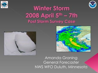
- 1. Amanda Graning General Forecaster NWS WFO Duluth, Minnesota
- 3. 00 Z April 6th 03 Z April 6th 06 Z April 6th 09Z April 6th 12 Z April 6th 15 Z April 6th 18 Z April 6th 21 Z April 6th 00 Z April 7th 03 Z April 7th 06 Z April 7th 09 Z April 7th 12Z April 7th 15 Z April 7th
- 10. Warm Cold
- 11. 00 Z Sunday, April 7 th 2008
- 12. 18Z Sunday 2008 Apr 6th 22Z Sunday 2008 Apr 6th 04Z Monday 2008 Apr 7th
- 13. KDLH 02Z Monday 2008 Apr 7th 18Z Sunday 2008 Apr 6th 22Z Sunday 2008 Apr 6th 02Z Monday 2008 Apr 7th
- 14. 00Z Monday 2008 Apr 7th 04Z Monday 2008 Apr 7th 20Z Sunday 2008 Apr 6th
- 18. Winter Storm Watch was issued (Friday Afternoon, April 4th) 48 hours prior to the start of the event Upgraded to a Winter Storm Warning 12 hours later, 36 hours before start of event
- 19. AREA FORECAST DISCUSSION NATIONAL WEATHER SERVICE DULUTH MN 310 PM CDT FRI APR 4 2008 …WITH A TIGHT THERMAL GRADIENT OVER OUR REGION...THERE IS STILL UNCERTAINTIES IN THE PLACEMENT AND TYPE OF PRECIPITATION FOR SOME AREAS...ESPECIALLY THE TWIN PORTS. … IMPRESSIVE FRONTOGENESIS WILL OCCUR... AND LEAD TO HEAVY SNOWFALL OVER MAINLY THE IRON RANGE … CROSS SECTIONS REVEAL INSTABILITY WILL BE PRESENT AS WELL...AND I WOULD NOT BE SURPRISED IF THERE WAS SOME THUNDERSNOW SATURDAY NIGHT INTO SUNDAY MORNING. SNOWFALL AMOUNTS OVER A FOOT WILL BE POSSIBLE… FURTHER SOUTH… THE TWIN PORTS AREA WILL BE IN A UNIQUE POSITION WHERE NORTHEAST WINDS OFF OF LAKE SUPERIOR AND UP THE HIGHER TERRAIN INLAND FROM LAKE SUPERIOR WILL CAUSE MORE COOLING IN THE LOW LEVELS...POSSIBLY LEADING TO SIGNIFICANT FREEZING RAIN SATURDAY NIGHT...THEN SNOW…
- 20. Winter Storm Watch (April 4 th , Friday afternoon) … . SIGNIFICANT SNOW IS EXPECTED WITH THIS SYSTEM TONIGHT THROUGH SUNDAY EVENING…THERE IS ALSO THE POTENTIAL FOR SIGNIFICANT FREEZING RAIN IN THE HIGHER TERRAIN AT THE HEAD OF LAKE SUPERIOR...INCLUDING PROCTOR...DULUTH… Northern Area …THE SNOW WILL DEVELOP SATURDAY NIGHT...AND BECOME QUITE HEAVY … Duluth Area … TEMPERATURES WILL BE CRITICAL DURING THIS EVENT...AND SMALL CHANGES WILL HAVE A BIG IMPACT ON THE TYPE OF PRECIPITATION EXPECTED. STAY TUNED TO LATER FORECASTS AS THIS STORM DEVELOPS.
- 21. URGENT - WINTER WEATHER MESSAGE NATIONAL WEATHER SERVICE DULUTH MN 930 PM CDT SAT APR 5 2008 ...MAJOR WINTER STORM TO IMPACT PORTIONS OF THE NORTHLAND... . ..SNOWFALL RATES OF 1 TO 2 INCHES PER HOUR WILL BE POSSIBLE... MAKING TRAVEL VERY DIFFICULT OR IMPOSSIBLE ACROSS NORTHEAST MINNESOTA. THIS WILL BE A HEAVY WET SNOW WITH A POTENTIAL FOR SIGNIFICANT DAMAGE TO TREES...LIMBS...AND POWER LINES…
- 22. URGENT - WINTER WEATHER MESSAGE 930 PM CDT SAT APR 5 2008 … ICE ACCUMULATION AND SIGNIFICANT WET SNOW ACCUMULATION BRING THE POTENTIAL FOR SIGNIFICANT DAMAGE TO TREES...LIMBS...AND POWER LINES… ...WINTER STORM WARNING REMAINS IN EFFECT UNTIL MIDNIGHT CDT SUNDAY NIGHT... … IF YOU PLAN TRAVEL NORTH AND WEST OF THE TWIN PORTS...PLEASE BE AWARE THAT SIGNIFICANT SNOW AND POOR DRIVING CONDITIONS EXIST ACROSS THE RANGE AND STRETCHING SOUTHWEST TO NORTHERN CASS COUNTY. URGENT - WINTER WEATHER MESSAGE 452 AM CDT SUN APR 6 2008 ...WINTER STORM WARNING REMAINS IN EFFECT UNTIL MIDNIGHT CDT TONIGHT...
- 23. Winter Storm Warning: Increased snowfall totals with each update Highlighted snowfall rates of 1-2 in per hour. Referenced MNDot’s reports of poor road conditions
Hinweis der Redaktion
- With this talk we will go over what happen, synoptic set up, forecasting challenges and difficulties in conveying the threat of this storm