SlideShare ist ein Scribd-Unternehmen logo
1 von 20
SITE ANALYSIS 
ALLAN’S WATER, FRASERS HILL 
CONTOUR & TOPOGRAPHY 
By: Lee Jo Yee, Chung Wei Jin, Lim Yee Qun, Leong Hui Yi, Hiew Eyang
By: Lee Jo Yee, Chung Wei Jin, Lim Yee Qun, Leong Hui Yi, Hiew Eyang 
Introduction 
Contour & Topography
FROM WATER LEVEL 
HIGHEST SLOPE : 15m 
DEEPEST POINT IN LAKE : 9m 
SHALLOWEST POINT : 1m 
By: Lee Jo Yee, Chung Wei Jin, Lim Yee Qun, Leong Hui Yi, Hiew Eyang 
Basic Information 
Contour & Topography
STEEPEST SURFACE ANGLE FLATEST SURFACE ANGLE 
87° 8° 
Contour & Topography 
By: Lee Jo Yee, Chung Wei Jin, Lim Yee Qun, Leong Hui Yi, Hiew Eyang
Contour & Topography 
STEEPEST AREA FLATTEST AREA 
By: Lee Jo Yee, Chung Wei Jin, Lim Yee Qun, Leong Hui Yi, Hiew Eyang
Contour & Topography 
STEEPEST AREA FLATTEST AREA 
By: Lee Jo Yee, Chung Wei Jin, Lim Yee Qun, Leong Hui Yi, Hiew Eyang
Contour & Topography 
STEEPEST AREA FLATTEST AREA 
By: Lee Jo Yee, Chung Wei Jin, Lim Yee Qun, Leong Hui Yi, Hiew Eyang
A A 
D D 
Contour & Topography 
By: Lee Jo Yee, Chung Wei Jin, Lim Yee Qun, Leong Hui Yi, Hiew Eyang 
COMPARISON BETWEEN SECTIONS
AREA A AREA D AREA H 
- LEAST STEEP 
- LEAST VEGE 
- STEEPER 
- VEGE 
- STEEPEST 
- MOST VEGE 
Contour & Topography 
By: Lee Jo Yee, Chung Wei Jin, Lim Yee Qun, Leong Hui Yi, Hiew Eyang
Contour & Topography 
By: Lee Jo Yee, Chung Wei Jin, Lim Yee Qun, Leong Hui Yi, Hiew Eyang 
Comparison 
Allan’s Water Paddock 
 STEEPER LANDSCAPE 
 THE LAKE IS AN ENCLOSED CURVE 
 AN OPEN PIECE OF LAND WITH LITTLE 
CHANGING IN TOPOGRAPHY
By: Lee Jo Yee, Chung Wei Jin, Lim Yee Qun, Leong Hui Yi, Hiew Eyang 
PROCESS 
1. TAKE PICTURE OF EVERY 
SECTION OF THE AREA 
2. USE HUMAN AS RATION TO 
CALCULATE HEIGHT OF 
SLOPES 
HEIGHT x RATIO = ACTUAL HEIGHT 
Contour & Topography
By: Lee Jo Yee, Chung Wei Jin, Lim Yee Qun, Leong Hui Yi, Hiew Eyang 
Access & Circulation 
• DURING RAINY DAYS, LAKE WATER LEVEL RISES 
• TOURISTS CANNOT PASS THROUGH 
• MANY CHANGES IN TOPOGRAPHY CAUSING IT TO BE HARD TO ACCESS 
Contour & Topography
By: Lee Jo Yee, Chung Wei Jin, Lim Yee Qun, Leong Hui Yi, Hiew Eyang 
View/ vista 
• SLOPE HAS DIFFERENT HEIGHTS WHICH GIVES DIFFERENT VIEWS WHEN TOURISTS STAND AT 
DIFFERENT AREAS 
Contour & Topography
CONTOUR & TOPOGRRAPHY 
By: Lee Jo Yee, Chung Wei Jin, Lim Yee Qun, Leong Hui Yi, Hiew Eyang 
Structure & Materiality 
• Topography was changed due to the construction of roads and buildings
By: Lee Jo Yee, Chung Wei Jin, Lim Yee Qun, Leong Hui Yi, Hiew Eyang 
Vegetation 
• The higher the slope, the taller the trees 
• The lower the slope, the shorter the trees 
Contour & Topography
Contour & Topography 
By: Jolene Hor, Te Li Theng, Koay Hui May, Choong Lai Mun, Ooi Zhi-Qian 
SWOT ANALYSIS 
• Orginality of nature 
remained. 
• Echo created by contour 
• Different views 
• Hardly accessible 
• Human pollution 
• Limited views 
• Collected water 
• Safety 
• Stability of structures 
• Water can be the main 
way to access to whole 
site. 
• Trees hole the soil 
together 
• Wild animal attack 
• Tree collapse after rain 
• Landslide 
• Polluted water
Contour & Topography 
STRENGTH 
• Allan’s Water remains originality of the nature simultaneously 
making it accessible 
• Open and sunny 
• Ecosystem is complete in the enclosed curve of the contour 
• Echo created by contour concentrates chirping of birds around lake 
area 
•Tourists get to experience the challenging geology 
•Different height and slopes of mountain helps in ecology studies 
By: Lee Jo Yee, Chung Wei Jin, Lim Yee Qun, Leong Hui Yi, Hiew Eyang
Contour & Topography 
WEAKNESS 
• Deep inside forest is hardly accessible 
• Human noise pollution caused by whistling of boatman might scare 
the birds away 
• Collected water become habitat to mosquitoes and leeches 
• Stability of structures is not ensured 
By: Lee Jo Yee, Chung Wei Jin, Lim Yee Qun, Leong Hui Yi, Hiew Eyang
OPPORTUNITY 
Contour & Topography 
• Lake can be the main access to the whole lake 
• Different types of tress can attract different species of birds 
• Waterfront/cross bridge/ new links for the convenience of tourists 
By: Lee Jo Yee, Chung Wei Jin, Lim Yee Qun, Leong Hui Yi, Hiew Eyang
Contour & Topography 
THREAT 
• Wild animals hidden in the jungle might attack tourists 
• Trees might collapse after rain due to the loosening of soil overtime 
and thus causing landslide to occur 
• Tourist who litter might cause the lake to be polluted 
By: Lee Jo Yee, Chung Wei Jin, Lim Yee Qun, Leong Hui Yi, Hiew Eyang

Weitere ähnliche Inhalte

Was ist angesagt?

architecture Case study yale university
architecture Case study yale universityarchitecture Case study yale university
architecture Case study yale universityNisarg bhavsar
 
HOUSING AT PARSIK HILL
HOUSING AT PARSIK HILLHOUSING AT PARSIK HILL
HOUSING AT PARSIK HILLShreya Mahajan
 
case study for cultual centes
case study for cultual centescase study for cultual centes
case study for cultual centesaudrey Manga
 
LANDSCAPE CASE STUDY
LANDSCAPE CASE STUDYLANDSCAPE CASE STUDY
LANDSCAPE CASE STUDYAmit Majumdar
 
High-Rise Iconic Buildings
High-Rise Iconic BuildingsHigh-Rise Iconic Buildings
High-Rise Iconic BuildingsDania Abdel-aziz
 
Mumbai High Rise Buildings Case studies of Kohinoor Square, Aquaria Grande, K...
Mumbai High Rise Buildings Case studies of Kohinoor Square, Aquaria Grande, K...Mumbai High Rise Buildings Case studies of Kohinoor Square, Aquaria Grande, K...
Mumbai High Rise Buildings Case studies of Kohinoor Square, Aquaria Grande, K...Prateek Srivastava
 
Case study Housing (Sem-VIth)
Case study Housing (Sem-VIth)Case study Housing (Sem-VIth)
Case study Housing (Sem-VIth)Amir Azhar
 
JAWAHAR KALA KENDRA JAIPUR case study
JAWAHAR KALA KENDRA JAIPUR case studyJAWAHAR KALA KENDRA JAIPUR case study
JAWAHAR KALA KENDRA JAIPUR case studyNihan Guetta
 
Urban design Case study GOA PANJIM
Urban design Case study GOA PANJIMUrban design Case study GOA PANJIM
Urban design Case study GOA PANJIMLalith Aditya
 
Landscape architecture spatial organisation lecture 3
Landscape architecture spatial organisation lecture 3Landscape architecture spatial organisation lecture 3
Landscape architecture spatial organisation lecture 3Bineet Chhajer
 
Riverfront development Case study Hoshangabad Thesis
Riverfront development  Case study Hoshangabad Thesis Riverfront development  Case study Hoshangabad Thesis
Riverfront development Case study Hoshangabad Thesis Praveen Mukati
 
Role of Indian Institute of Architects as a professional body in India
Role of Indian Institute of Architects as a professional body in IndiaRole of Indian Institute of Architects as a professional body in India
Role of Indian Institute of Architects as a professional body in IndiaKrittika Walia
 
Waterfront development
Waterfront developmentWaterfront development
Waterfront developmentmisschand
 
Case study college of architecture
Case study college of architecture Case study college of architecture
Case study college of architecture Abhijeet Roy
 

Was ist angesagt? (20)

Charles correa
Charles correaCharles correa
Charles correa
 
architecture Case study yale university
architecture Case study yale universityarchitecture Case study yale university
architecture Case study yale university
 
HOUSING AT PARSIK HILL
HOUSING AT PARSIK HILLHOUSING AT PARSIK HILL
HOUSING AT PARSIK HILL
 
case study for cultual centes
case study for cultual centescase study for cultual centes
case study for cultual centes
 
LANDSCAPE CASE STUDY
LANDSCAPE CASE STUDYLANDSCAPE CASE STUDY
LANDSCAPE CASE STUDY
 
MARINA BAY SINGAPORE - URBAN CASE STUDY
MARINA BAY SINGAPORE - URBAN CASE STUDYMARINA BAY SINGAPORE - URBAN CASE STUDY
MARINA BAY SINGAPORE - URBAN CASE STUDY
 
High-Rise Iconic Buildings
High-Rise Iconic BuildingsHigh-Rise Iconic Buildings
High-Rise Iconic Buildings
 
Mumbai High Rise Buildings Case studies of Kohinoor Square, Aquaria Grande, K...
Mumbai High Rise Buildings Case studies of Kohinoor Square, Aquaria Grande, K...Mumbai High Rise Buildings Case studies of Kohinoor Square, Aquaria Grande, K...
Mumbai High Rise Buildings Case studies of Kohinoor Square, Aquaria Grande, K...
 
Climate responsive architecture (1)
Climate responsive architecture (1)Climate responsive architecture (1)
Climate responsive architecture (1)
 
Case study Housing (Sem-VIth)
Case study Housing (Sem-VIth)Case study Housing (Sem-VIth)
Case study Housing (Sem-VIth)
 
JAWAHAR KALA KENDRA JAIPUR case study
JAWAHAR KALA KENDRA JAIPUR case studyJAWAHAR KALA KENDRA JAIPUR case study
JAWAHAR KALA KENDRA JAIPUR case study
 
Urban design Case study GOA PANJIM
Urban design Case study GOA PANJIMUrban design Case study GOA PANJIM
Urban design Case study GOA PANJIM
 
Landscape architecture spatial organisation lecture 3
Landscape architecture spatial organisation lecture 3Landscape architecture spatial organisation lecture 3
Landscape architecture spatial organisation lecture 3
 
High rise structure & core
High rise  structure & coreHigh rise  structure & core
High rise structure & core
 
Site Analysis
Site Analysis Site Analysis
Site Analysis
 
Riverfront development Case study Hoshangabad Thesis
Riverfront development  Case study Hoshangabad Thesis Riverfront development  Case study Hoshangabad Thesis
Riverfront development Case study Hoshangabad Thesis
 
Role of Indian Institute of Architects as a professional body in India
Role of Indian Institute of Architects as a professional body in IndiaRole of Indian Institute of Architects as a professional body in India
Role of Indian Institute of Architects as a professional body in India
 
Waterfront development
Waterfront developmentWaterfront development
Waterfront development
 
Case study college of architecture
Case study college of architecture Case study college of architecture
Case study college of architecture
 
Aranya Low Cost Housing
Aranya Low Cost HousingAranya Low Cost Housing
Aranya Low Cost Housing
 

Andere mochten auch

Andere mochten auch (20)

Site Analysis
Site AnalysisSite Analysis
Site Analysis
 
Site analysis-example
Site analysis-exampleSite analysis-example
Site analysis-example
 
Topography powerpoint
Topography powerpointTopography powerpoint
Topography powerpoint
 
What is Topography
What is TopographyWhat is Topography
What is Topography
 
Site planning
Site planningSite planning
Site planning
 
Site Analysis
Site AnalysisSite Analysis
Site Analysis
 
Site analysis
Site analysis Site analysis
Site analysis
 
1. 10 site analysis
1. 10 site analysis1. 10 site analysis
1. 10 site analysis
 
Site planning kevin lynch
Site planning kevin lynchSite planning kevin lynch
Site planning kevin lynch
 
Topographic Maps Notes
Topographic Maps NotesTopographic Maps Notes
Topographic Maps Notes
 
Site analysis
Site analysisSite analysis
Site analysis
 
Coutour & topography
Coutour & topographyCoutour & topography
Coutour & topography
 
Basic topographic mapping
Basic topographic mappingBasic topographic mapping
Basic topographic mapping
 
Reading a topographic map
Reading a topographic mapReading a topographic map
Reading a topographic map
 
SPP Site 1 - SWOT Analysis
SPP Site 1 - SWOT Analysis SPP Site 1 - SWOT Analysis
SPP Site 1 - SWOT Analysis
 
Topographic maps for UDL lesson
Topographic maps for UDL lessonTopographic maps for UDL lesson
Topographic maps for UDL lesson
 
Rasem Badran at Ajman University
Rasem Badran at Ajman UniversityRasem Badran at Ajman University
Rasem Badran at Ajman University
 
Topo Symbols
Topo SymbolsTopo Symbols
Topo Symbols
 
Ajman Analysis Final
Ajman Analysis FinalAjman Analysis Final
Ajman Analysis Final
 
Ajman Urban Design
Ajman Urban DesignAjman Urban Design
Ajman Urban Design
 

Ähnlich wie SITE ANALYSIS - TOPOGRAPHY

Final presentation
Final presentationFinal presentation
Final presentationPreston Liew
 
GCSE OCR B Revision pack 2013
GCSE OCR B Revision pack 2013GCSE OCR B Revision pack 2013
GCSE OCR B Revision pack 2013Mrs Coles
 
Chapter 9 Water Resources.pdf
Chapter 9 Water Resources.pdfChapter 9 Water Resources.pdf
Chapter 9 Water Resources.pdfThobaniMbhele
 
Chapter4groundwaterhydrology 130630055824-phpapp02
Chapter4groundwaterhydrology 130630055824-phpapp02Chapter4groundwaterhydrology 130630055824-phpapp02
Chapter4groundwaterhydrology 130630055824-phpapp02Cleophas Rwemera
 
Chapter 4 groundwater hydrology
Chapter 4 groundwater hydrologyChapter 4 groundwater hydrology
Chapter 4 groundwater hydrologyMohammed Salahat
 
Adaptive methods to restore Lake Erie hydrology_Kroll
Adaptive methods to restore Lake Erie hydrology_KrollAdaptive methods to restore Lake Erie hydrology_Kroll
Adaptive methods to restore Lake Erie hydrology_KrollHealthy Lakes, Healthy Lives
 
Enthonyli
EnthonyliEnthonyli
Enthonyliihsl
 
Paper 1 revision 29.5.13 bv
Paper 1 revision 29.5.13 bvPaper 1 revision 29.5.13 bv
Paper 1 revision 29.5.13 bvtudorgeog
 
Water on the land
Water on the landWater on the land
Water on the landlesliehome
 
Slideshare_Geomorphology, Remote Sensing and G.I.S._Dr AVD.pptx
Slideshare_Geomorphology, Remote Sensing and G.I.S._Dr AVD.pptxSlideshare_Geomorphology, Remote Sensing and G.I.S._Dr AVD.pptx
Slideshare_Geomorphology, Remote Sensing and G.I.S._Dr AVD.pptxDr.Anil Deshpande
 
water resources.pptx
water resources.pptxwater resources.pptx
water resources.pptxSatyam M
 
Watershed charecteristics
Watershed charecteristicsWatershed charecteristics
Watershed charecteristicsVipin Mishra
 
PANTAI KERACHUT PART 1
PANTAI KERACHUT PART 1PANTAI KERACHUT PART 1
PANTAI KERACHUT PART 1Yaseen Syed
 

Ähnlich wie SITE ANALYSIS - TOPOGRAPHY (20)

Final presentation
Final presentationFinal presentation
Final presentation
 
GCSE OCR B Revision pack 2013
GCSE OCR B Revision pack 2013GCSE OCR B Revision pack 2013
GCSE OCR B Revision pack 2013
 
Chapter 9 Water Resources.pdf
Chapter 9 Water Resources.pdfChapter 9 Water Resources.pdf
Chapter 9 Water Resources.pdf
 
Chapter4groundwaterhydrology 130630055824-phpapp02
Chapter4groundwaterhydrology 130630055824-phpapp02Chapter4groundwaterhydrology 130630055824-phpapp02
Chapter4groundwaterhydrology 130630055824-phpapp02
 
floods.pptx
floods.pptxfloods.pptx
floods.pptx
 
Chapter 4 groundwater hydrology
Chapter 4 groundwater hydrologyChapter 4 groundwater hydrology
Chapter 4 groundwater hydrology
 
Adaptive methods to restore Lake Erie hydrology_Kroll
Adaptive methods to restore Lake Erie hydrology_KrollAdaptive methods to restore Lake Erie hydrology_Kroll
Adaptive methods to restore Lake Erie hydrology_Kroll
 
Part 1
Part 1Part 1
Part 1
 
Water Chapter 1 Fetter - Applied Hydrogeology
Water Chapter 1 Fetter - Applied Hydrogeology Water Chapter 1 Fetter - Applied Hydrogeology
Water Chapter 1 Fetter - Applied Hydrogeology
 
Presentation 2: Baseline Assessment Findings
Presentation 2: Baseline Assessment FindingsPresentation 2: Baseline Assessment Findings
Presentation 2: Baseline Assessment Findings
 
Introduction to hydrology
Introduction to hydrologyIntroduction to hydrology
Introduction to hydrology
 
Enthonyli
EnthonyliEnthonyli
Enthonyli
 
Paper 1 revision 29.5.13 bv
Paper 1 revision 29.5.13 bvPaper 1 revision 29.5.13 bv
Paper 1 revision 29.5.13 bv
 
Water on the land
Water on the landWater on the land
Water on the land
 
Slideshare_Geomorphology, Remote Sensing and G.I.S._Dr AVD.pptx
Slideshare_Geomorphology, Remote Sensing and G.I.S._Dr AVD.pptxSlideshare_Geomorphology, Remote Sensing and G.I.S._Dr AVD.pptx
Slideshare_Geomorphology, Remote Sensing and G.I.S._Dr AVD.pptx
 
5.2.1 Lecture - Spatial Scales
5.2.1 Lecture - Spatial Scales5.2.1 Lecture - Spatial Scales
5.2.1 Lecture - Spatial Scales
 
water resources.pptx
water resources.pptxwater resources.pptx
water resources.pptx
 
Rivers
RiversRivers
Rivers
 
Watershed charecteristics
Watershed charecteristicsWatershed charecteristics
Watershed charecteristics
 
PANTAI KERACHUT PART 1
PANTAI KERACHUT PART 1PANTAI KERACHUT PART 1
PANTAI KERACHUT PART 1
 

Mehr von YeeQun

Building Science 2 Project 2
Building Science 2 Project 2Building Science 2 Project 2
Building Science 2 Project 2YeeQun
 
Bservice report
Bservice report Bservice report
Bservice report YeeQun
 
sem 2.5 measured drawings
sem 2.5 measured drawingssem 2.5 measured drawings
sem 2.5 measured drawingsYeeQun
 
Pejabat agama islam klang
Pejabat agama islam klangPejabat agama islam klang
Pejabat agama islam klangYeeQun
 
Walter gropius
Walter gropiusWalter gropius
Walter gropiusYeeQun
 
Project 1- Skretch Journal
Project 1- Skretch JournalProject 1- Skretch Journal
Project 1- Skretch JournalYeeQun
 
Retreat House - Sketch Journal
Retreat House - Sketch JournalRetreat House - Sketch Journal
Retreat House - Sketch JournalYeeQun
 
BIRD WATCHING TOWER - SKETCH JOURNAL
BIRD WATCHING TOWER - SKETCH JOURNALBIRD WATCHING TOWER - SKETCH JOURNAL
BIRD WATCHING TOWER - SKETCH JOURNALYeeQun
 

Mehr von YeeQun (9)

Building Science 2 Project 2
Building Science 2 Project 2Building Science 2 Project 2
Building Science 2 Project 2
 
Bservice report
Bservice report Bservice report
Bservice report
 
sem 2.5 measured drawings
sem 2.5 measured drawingssem 2.5 measured drawings
sem 2.5 measured drawings
 
Pejabat agama islam klang
Pejabat agama islam klangPejabat agama islam klang
Pejabat agama islam klang
 
BCON
BCONBCON
BCON
 
Walter gropius
Walter gropiusWalter gropius
Walter gropius
 
Project 1- Skretch Journal
Project 1- Skretch JournalProject 1- Skretch Journal
Project 1- Skretch Journal
 
Retreat House - Sketch Journal
Retreat House - Sketch JournalRetreat House - Sketch Journal
Retreat House - Sketch Journal
 
BIRD WATCHING TOWER - SKETCH JOURNAL
BIRD WATCHING TOWER - SKETCH JOURNALBIRD WATCHING TOWER - SKETCH JOURNAL
BIRD WATCHING TOWER - SKETCH JOURNAL
 

SITE ANALYSIS - TOPOGRAPHY

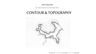
  • 1. SITE ANALYSIS ALLAN’S WATER, FRASERS HILL CONTOUR & TOPOGRAPHY By: Lee Jo Yee, Chung Wei Jin, Lim Yee Qun, Leong Hui Yi, Hiew Eyang
  • 2. By: Lee Jo Yee, Chung Wei Jin, Lim Yee Qun, Leong Hui Yi, Hiew Eyang Introduction Contour & Topography
  • 3. FROM WATER LEVEL HIGHEST SLOPE : 15m DEEPEST POINT IN LAKE : 9m SHALLOWEST POINT : 1m By: Lee Jo Yee, Chung Wei Jin, Lim Yee Qun, Leong Hui Yi, Hiew Eyang Basic Information Contour & Topography
  • 4. STEEPEST SURFACE ANGLE FLATEST SURFACE ANGLE 87° 8° Contour & Topography By: Lee Jo Yee, Chung Wei Jin, Lim Yee Qun, Leong Hui Yi, Hiew Eyang
  • 5. Contour & Topography STEEPEST AREA FLATTEST AREA By: Lee Jo Yee, Chung Wei Jin, Lim Yee Qun, Leong Hui Yi, Hiew Eyang
  • 6. Contour & Topography STEEPEST AREA FLATTEST AREA By: Lee Jo Yee, Chung Wei Jin, Lim Yee Qun, Leong Hui Yi, Hiew Eyang
  • 7. Contour & Topography STEEPEST AREA FLATTEST AREA By: Lee Jo Yee, Chung Wei Jin, Lim Yee Qun, Leong Hui Yi, Hiew Eyang
  • 8. A A D D Contour & Topography By: Lee Jo Yee, Chung Wei Jin, Lim Yee Qun, Leong Hui Yi, Hiew Eyang COMPARISON BETWEEN SECTIONS
  • 9. AREA A AREA D AREA H - LEAST STEEP - LEAST VEGE - STEEPER - VEGE - STEEPEST - MOST VEGE Contour & Topography By: Lee Jo Yee, Chung Wei Jin, Lim Yee Qun, Leong Hui Yi, Hiew Eyang
  • 10. Contour & Topography By: Lee Jo Yee, Chung Wei Jin, Lim Yee Qun, Leong Hui Yi, Hiew Eyang Comparison Allan’s Water Paddock  STEEPER LANDSCAPE  THE LAKE IS AN ENCLOSED CURVE  AN OPEN PIECE OF LAND WITH LITTLE CHANGING IN TOPOGRAPHY
  • 11. By: Lee Jo Yee, Chung Wei Jin, Lim Yee Qun, Leong Hui Yi, Hiew Eyang PROCESS 1. TAKE PICTURE OF EVERY SECTION OF THE AREA 2. USE HUMAN AS RATION TO CALCULATE HEIGHT OF SLOPES HEIGHT x RATIO = ACTUAL HEIGHT Contour & Topography
  • 12. By: Lee Jo Yee, Chung Wei Jin, Lim Yee Qun, Leong Hui Yi, Hiew Eyang Access & Circulation • DURING RAINY DAYS, LAKE WATER LEVEL RISES • TOURISTS CANNOT PASS THROUGH • MANY CHANGES IN TOPOGRAPHY CAUSING IT TO BE HARD TO ACCESS Contour & Topography
  • 13. By: Lee Jo Yee, Chung Wei Jin, Lim Yee Qun, Leong Hui Yi, Hiew Eyang View/ vista • SLOPE HAS DIFFERENT HEIGHTS WHICH GIVES DIFFERENT VIEWS WHEN TOURISTS STAND AT DIFFERENT AREAS Contour & Topography
  • 14. CONTOUR & TOPOGRRAPHY By: Lee Jo Yee, Chung Wei Jin, Lim Yee Qun, Leong Hui Yi, Hiew Eyang Structure & Materiality • Topography was changed due to the construction of roads and buildings
  • 15. By: Lee Jo Yee, Chung Wei Jin, Lim Yee Qun, Leong Hui Yi, Hiew Eyang Vegetation • The higher the slope, the taller the trees • The lower the slope, the shorter the trees Contour & Topography
  • 16. Contour & Topography By: Jolene Hor, Te Li Theng, Koay Hui May, Choong Lai Mun, Ooi Zhi-Qian SWOT ANALYSIS • Orginality of nature remained. • Echo created by contour • Different views • Hardly accessible • Human pollution • Limited views • Collected water • Safety • Stability of structures • Water can be the main way to access to whole site. • Trees hole the soil together • Wild animal attack • Tree collapse after rain • Landslide • Polluted water
  • 17. Contour & Topography STRENGTH • Allan’s Water remains originality of the nature simultaneously making it accessible • Open and sunny • Ecosystem is complete in the enclosed curve of the contour • Echo created by contour concentrates chirping of birds around lake area •Tourists get to experience the challenging geology •Different height and slopes of mountain helps in ecology studies By: Lee Jo Yee, Chung Wei Jin, Lim Yee Qun, Leong Hui Yi, Hiew Eyang
  • 18. Contour & Topography WEAKNESS • Deep inside forest is hardly accessible • Human noise pollution caused by whistling of boatman might scare the birds away • Collected water become habitat to mosquitoes and leeches • Stability of structures is not ensured By: Lee Jo Yee, Chung Wei Jin, Lim Yee Qun, Leong Hui Yi, Hiew Eyang
  • 19. OPPORTUNITY Contour & Topography • Lake can be the main access to the whole lake • Different types of tress can attract different species of birds • Waterfront/cross bridge/ new links for the convenience of tourists By: Lee Jo Yee, Chung Wei Jin, Lim Yee Qun, Leong Hui Yi, Hiew Eyang
  • 20. Contour & Topography THREAT • Wild animals hidden in the jungle might attack tourists • Trees might collapse after rain due to the loosening of soil overtime and thus causing landslide to occur • Tourist who litter might cause the lake to be polluted By: Lee Jo Yee, Chung Wei Jin, Lim Yee Qun, Leong Hui Yi, Hiew Eyang