1. STEVE SINDIONG – PROJECT EXAMPLE
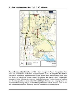
Auburn Transportation Plan (Auburn, WA) – Steve managed
the Auburn Transportation Plan,
which was updated as a result of two recent annexations to the City. As part of this effort, he
oversaw the inventorying of pedestrian and bicycle facilities within the annexation areas, using
GIS technology. He also led a public outreach process that was used to identify transportation
issues and needs, including non-motorized needs. Steve oversaw the identification of roadway
and other transportation needs based on future (2030) population and land use projections, and
Synchro traffic modeling analysis, identified transportation solutions to meet the future needs,
and oversaw the preparation of planning level cost estimates for proposed projects.
2. STEVE SINDIONG – PROJECT EXAMPLE
Lynnwood Non-Motorized Skeleton System Plan (Lynnwood, WA) – Steve managed
this
study that developed a pedestrian and bicycle system to serve schools, parks, transit and other
major activity centers within Lynnwood, and provide connectivity to systems in adjacent
communities. A “skeleton system” for both pedestrians and bicycles was developed based upon
a review of the systems using established evaluation criteria. GIS was used to help evaluate
and prioritize system segments. Planning level cost estimates were prepared for all of the
skeleton system segments and a priority list of projects was identified based on the evaluation
and other data.
3. STEVE SINDIONG – PROJECT EXAMPLES
SE Redmond Area Transportation Study (Redmond, WA) – Steve was the lead planner for
this study that examined long-term transportation needs for the southeast part of Redmond,
WA, one of the fastest growing areas of the City. Steve had a significant role in planning and
facilitating public outreach, evaluating existing conditions, identifying multi-modal transportation
needs, developing project concepts and evaluating projects. As part of the analysis, Steve
identified existing and planned pedestrian facilities within the congested area of SR 520 near
Redmond Way, and made recommendations for future pedestrian facilities, as shown above, to
improve connectivity across Redmond Way, and between downtown Redmond and southeast
Redmond, as well as to the future planned light rail station and park & ride facility adjacent to
SR 520.
4. STEVE SINDIONG – PROJECT EXAMPLE
A new north-south non-motorized facility could connect Channelization improvements on all legs and dual turn lanes to the
to the future office area north of Richards Road and the I-90 Onramp are recommended at the intersection of 150th Ave SE at
Mountains to Sound Greenway and other uses south of SE 37th Street.
I-90.
Eastgate Preliminary Screening Analysis (Bellevue, WA) – A number of significant changes
have occurred in the Eastgate area since completion of the Eastgate/I-90 Corridor Study in
2003, including construction of the Eastgate Park-and-Ride expansion, direct access ramps to
142nd Place SE, expansion of Bellevue College, new commercial and office development, and
transit service revisions. The Eastgate/ I-90 Corridor Study had a planning horizon of 2020.
The City plans to conduct an Eastgate Mixed-Use Employment Center Study that will examine
land use, transportation, urban design, and annexation issues and make recommendations for
land use / zoning changes and multi-modal transportation improvements. The study will have a
2030 planning horizon, and is anticipated to begin in early 2010. The City will be considering
annexation of a large unincorporated residential area south of I-90 on a parallel timetable.
Steve managed a preliminary screening analysis that was needed prior to the Employment
Center Study to determine whether additional land uses, and of what magnitude, would be
feasible in the Eastgate area. The study conducted traffic operations analysis (using Synchro) to
analyze the traffic operations at area intersections, for two land use alternatives, for the AM and
PM peak periods. Potential optimization strategies were identified for the intersections based on
the analysis. In addition, transit and non-motorized strategies were explored, and order of
magnitude costs were prepared for those improvements identified as feasible solutions. Steve
prepared the above graphics to easily convey to staff some of the proposed solutions.
5. STEVE SINDIONG – PROJECT EXAMPLE
Tukwila Bicycle Friendly Routes and Missing Sidewalks Segments Report (Tukwila, WA)
– Steve managed this project that made recommendations for nearly 40 high priority corridors
within the City of Tukwila, WA. This first stage of the project included the preparation of an
improvement options report, which identified existing conditions, key issues and constraints,
overall context, and alternatives for the pedestrian and bicycle improvements. Upon review by
the City, and selection of a preferred solution, a design report was prepared which included the
preliminary design for each corridor using CAD overlaid on aerials, the proposed cross-section,
project description and order of magnitude costs. Steve also prepared an evaluation of all
corridors based on selected criteria, to identify projects that should be implemented first. Steve
prepared a number of graphics, including the above graphic, to convey various types of
improvements that could be implemented.
6. STEVE SINDIONG – PROJECT EXAMPLE
Evergreen Way Corridor Revitalization Plan (Everett, WA) – Steve evaluated each of the
SWIFT bus rapid transit station areas to determine existing major activity centers, land uses and
pedestrian facilities. In general, commuters are highly likely to walk within a ¼ mile distance to
transit stops, and a ½ mile distance to high capacity transit, such as BRT. These walking
distances were overlaid with the stations and land uses and pedestrian facilities to determine
gaps or barriers for pedestrians. In addition, potential new pedestrian connections were
identified between activity centers and higher density residential areas to streets served by
transit, where none exist today, or where pedestrians are required to walk long distances. These
pedestrian connections could be in the form multi-use trails through easements, or conditioned
to new development.