
Empfohlen
Weitere ähnliche Inhalte
Was ist angesagt?
Was ist angesagt? (20)
Andere mochten auch
Andere mochten auch (20)
Ähnlich wie Ancient Egypt by Charles & Jetson
Ähnlich wie Ancient Egypt by Charles & Jetson (20)
Mehr von Ms Wilson
Mehr von Ms Wilson (20)
Kürzlich hochgeladen
Kürzlich hochgeladen (20)
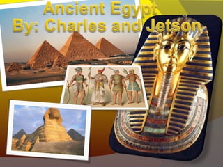
Ancient Egypt by Charles & Jetson
- 2. Map Of Ancient Egypt Ancient Egypt was considered one of the longest civilization in Africa. It was located along the middle to lower reaches of the Nile River. The kingdom reached from the Nile Delta in the north, as far as the south of Jebel Barkal at the fourth Cataract. Ancient Egypt lasted over 3000 years because they were surrounded by many natural barriers that includes the eastern and western deserts. The east and western deserts were very effective because if you try to get to Egypt with a big army you would get dehydrated since it’s a very wide desert. The other two barriers are the Mediterranean Sea and the cataracts on the south. Egyptian Map w/ Major cities Cities Egyptian Empire KEY Mediterranean Sea Red Sea
- 5. Social Structure The very top of Ancient Egyptian social is the Pharaoh since he controls basically everything, the Army, the Politics etc. The second highest lies the nobles since every noble was related to the Pharaoh, there were also the priests and the pharaoh’s trusted man which is the Viziers. The third highest of the Ancient Egyptian population are the traders, shopkeepers, scribes and artisans. The scribes were the only Egyptians who knew how to read and write, standing out from the surrounding illiteracy by their command of the secret skills of reading and writing. The Fourth least important of the Egyptian social structures were the farmers herders and workers. At the bottom of all the different classes of people in ancient Egypt are the slaves and unskilled workers. They represents a great percent of the Egyptian population. They support all the classes above them which is why they are at the base of the Social structure Social Pyramid