Paraguay Presentation English
•Als PPT, PDF herunterladen•
2 gefällt mir•1,361 views


Empfohlen
Weitere ähnliche Inhalte
Was ist angesagt?
Was ist angesagt? (20)
Andere mochten auch
Andere mochten auch (20)
Paraguay Presentation English
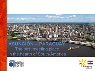
- 1. ASUNCIÓN – PARAGUAY The best meeting place In the hearth of South-America
- 2. Paraguay Area (km2) 406.752 Lenguage Spanish and Guaraní Currency Guaraní Population PIB (MM USD) Capital Other important cities Political division and Government system Most important products 6.100.000 13.500 Asunción Ciudad del Este, Encarnación, Concepción Democratic Republic. 3 Powers 17 Departaments. 2 Regions. Hidroenergy, Food (cereals, meat), Comerce and Services
- 3. Regions and Population 60% Of the total area 3% Of the total population Occidental Region 70% 70% UNDER 35 UNDER 35 YEARS YEARS 40% Of the total area 97% 97% Of the total Of the total population population Oriental Region
- 4. Land of Water Paraguay River Acuífero Guaraní Pilcomayo River Mayor sweetwater reserve per inhabitant of the world Paraná River
- 5. Air Conectivity Venezuela Colombia Guayana Surinam Guayana Francesa From ASU to Flight Time Buenos Aires Chile Argentina Uruguay 1.20 1.45 2.30 Santa Cruz Bolivia 2.05 Santiago Perú Sao Paulo Montevideo Brasil 1.40 Curitiba Ecuador 1.30 Lima 3.35 Conections to the rest of de South-America, Central-America, EE.UU and Europe Via Sao Paulo and Buenos Aires with a real minimum conecting time
- 6. Airline Companies With direct flights to Asunción
- 7. Airlines Companies With connections and representation in Paraguay
- 9. Asunción A City that offers You the best BARS – RESTAURANTS - CAFES PUBS – KARAOKES –DISCOTECS MOVIES – THEATER – CONCERTS SHOPPING CENTERS HISTORICAL CENTER AND FOLKLORE
- 10. Asunción The cheapest City In the World since 2003
- 11. Hotel Infrastructure 61 Hotels 2.700 Rooms 5.700 Beds (3 to 5 Stars)
- 15. South-Oriental Region Asunción – Jesuit Missions - Waterfalls
- 16. Jesuit Missions (Encarnación) (Excursions with 2 days/1 night from Asunción)
- 18. Ciudad del Este Shopping (Ciudad del Este) - Itaipú – Waterfalls (2 o 3 days excursion from Asunción)
- 19. Other touristic options Ypacarai Lake – San Bernardino (Half day excursion from Asunción)
- 20. Golf 3 Golf Courses in the Great Asunción Resort del Yacht & Golf Club del Paraguay Carlos Franco Golf Club Asunción Golf Club 1 Golf Course in the Yguazú Area Paraná Country Club (cerca de Ciudad del Este) 1 Golf Course in Encarnación AguaVista Golf & Country Club * *in construction
- 21. Ecoturismo Bird Watching 700 especies in 5 eco-regions Safari photo 170 especies of mamífers, some of them exclusif of the eco-regions Adventure y extreme sports. Fishing
- 22. Paraguay River Chaco and Pantanal
- 24. Gracias! THANK YOU Aguiyé!
Hinweis der Redaktion
- El Paraguay es un país con mucha tierra disponible y una baja densidad poblacional de solamente 15 habitantes por m2. El Chaco ofrece excelentes oportunidades debido a su bajísima ocupación.
- The Guarani aquifer reaches its minimal distance to the surface in Paraguayan territory (80 m) Numerous rivers and water courses through the country El Paraguay tiene dos grandes ríos, el Paraguay que lo cruza de norte a sur, dividiéndolo en dos regiones y el Paraná, que demarca su límite al este con Brasil y al sur con Argentina. Ambos con excelentes condiciones de navegabilidad para el transporte de productos de todo tipo (granos, liquidos, contenedores, etc.)