
Empfohlen
Weitere ähnliche Inhalte
Was ist angesagt?
Was ist angesagt? (16)
Ähnlich wie Phi phi island waree
Ähnlich wie Phi phi island waree (20)
Mehr von PORARDKAMON
Mehr von PORARDKAMON (20)
Kürzlich hochgeladen
Kürzlich hochgeladen (20)
Phi phi island waree
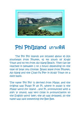
- 1. Phi PhiIsland The Phi Phi islands are located about 45 Km southeast from Phuket, 42 km south of Krabi Town and 40 km from Ao Nang Beach. They can be reached in between 1 to 3 hours depending on the type of boat you choose. Boats leave from Phuket, Ao Nang and the Chao Fa Pier in Krabi Town on a daily basis. The name 'Phi Phi' is derived from Malay, and the original was Pulao Pi ah Pi, where in pulao is the Malay word for island , and Pi, pronounced with a soft 'p' sound, was very close in pronunciation to the English word 'bee'; the ah was dropped, so the name was said something like Bee Bee.
- 2. Later the p was pronounced with a stronger aspiration and the name became the Phi Phi (Pee Pee) we know today. The name originally referred to the mangrove wood found there. There are 6 islands in the Phi Phi group; Phi Phi Don, Phi Phi Ley, BidaNok, BidaNai, Koh Yung, and KohPhai; total land area is 42 square kilometers. The islands were declared a National Park in 1983, and development is limited to Koh Phi Phi Don only. All other islands are uninhabited. Yung Island lies to the north of Phi Phi Don. there is a rocky beach on the east side, and a smaller strand of sand in a fold of the hill. Many beautiful and various corals are found there. Good for shallow snorkeling. Phai Island lies also to the north of Phi Phi Don, not far from KohYung . Sandy beaches are on the north and east sides of the island. Broad coral reefs stretch away into the south. Phi Phi Don Island covers a total area of 28 square kilometers: 8 km in length and 3.5 km at its broadest point. At the north end is Cape LaemTohng, where there is a Chao Ley, or sea
- 3. gipsy village. These sea gipsies emigrated from KohLipeh in Tarutao National Park, near the border with Malaysia and lived on the islands long before tourism arrived. There are two long beaches next to the main town - the two curving bays of Ton Sai and LohDalam. The town was hit hard by the tsunami on December 26th 2004, but now things are all back to normal.