
Recommended
More Related Content
Viewers also liked
Similar to NostalgicOutdoors™- Buffalo National River- Upper District Hiking Trails
Similar to NostalgicOutdoors™- Buffalo National River- Upper District Hiking Trails (20)
More from NostalgicOutdoors™
More from NostalgicOutdoors™ (20)
Recently uploaded
Recently uploaded (20)
NostalgicOutdoors™- Buffalo National River- Upper District Hiking Trails
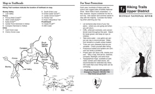
- 1. Hiking Trails Upper District buffalo national river Hiking Trail numbers indicate the location of trailhead on map. Map to Trailheads Each year, hundreds of hikers walk the scenic and rugged trails of Buffalo National River. Most make it back unassisted – a few, however, require a stretcher for the re- turn trip. Use caution and common sense to stay with the majority. Consider the follow- ing when planning your trip: Let someone else know of your trip• plans – where you are going and when you will return. Cliffs, unfenced overlooks, and uneven• terrain exist throughout the park. Watch for loose gravel, and keep an eye on children. Take extra water – one gallon per per-• son per day is recommended. Water from streams is unsafe unless treated. T• icks can carry diseases that are pre- ventable. Check yourself after hiking. Poisonous snakes and spiders are com-• mon but rarely a problem. Proper gear can save a life, maybe your• own. Take a map, first-aid kit, matches, compass, flashlight, and extra food. Topographical maps, available at park• visitor centers and retail stores, are recommended for extended day hikes. Old roads that cross hiking trails can be confusing. Boxley Valley 1 Lost Valley Ponca 2 Ponca-Steel CreekBRT 3 Steel Creek-KylesBRT 4 Kyles-ErbieBRT 5 Center Point-Hemmed in Hollow 6 Compton-Hemmed in Hollow Erbie 7 Cecil Cove Loop 8 Cherry Grove Loop 9 South Erbie Loop 10 Erbie-Cedar GroveBRT 11 Cedar Grove-OzarkBRT 12 Ponds Trail 13 Koen Interpretive Trail Pruitt/Ozark 14 Ozark-PruittBRT 15 Mill Creek For Your Protection Pruitt Visitor Center: 870-446-5373 Emergency Dispatch: 888-692-1162 http://www.nps.gov/buff
- 2. About This Brochure This handout includes a sampling of day hikes in the upper district of Buffalo National River. The list is not all-inclusive; other trails exist that require greater time commitments or have trailheads ac- cessible only by canoe. Many of the hikes listed below can be combined for overnight trips. Topographical maps contain more detailed information and are recommended for use on all trails in the park. Maps are sold in park contact stations and local retail stores. Trail Information and Regulations The Buffalo River Trail parallels the national river, following bluff line, meandering up side canyons, and dropping into hollows. Views of the river accent the way. Other hikes lead to scenic vistas, homesteads, and historic cemeteries. Trail difficulty varies, ranging from wheelchair accessible terrain to steep climbs over rocky slope. Please assist us in protecting the park by adhering to the following: Hiking Trails are posted with white mark-• ers – horse/hiking trails with yellow markers. Hikers may travel on horse/ hiker trails, but horses are not allowed on hiking trails. Pets are not allowed on trails.• Mountain biking is prohibited on all hik-• ing and horseback trails. All-terrain vehicles are prohibited in the• park. Stay on the trail – shortcuts create ero-• sion. If you must travel cross-country, avoid• stepping on lichens and fragile plants. Leave no permanent mark of your travel. Trash begets trash – please pack out• your own and as much as you can carry of others. Leave things as you find them. All• plants, animals, rocks, historic features, and archeological sites are protected by law. Trail Descriptions Area Trailhead Distance Hiking Time Features Boxley Valley 1. Lost Valley Lost Valley Campground 2.3 mi 3.7 km (rt)* 2 1/2 hours Easy-moderate; waterfall, small cave, bluff shelter, beech tree stand Ponca Area 2. Ponca-Steel Creek Ponca Lowwater Bridge 2.3 mi 3.7 km (o) 1 1/2 hours Easy-moderate; spectacular views of the river from atop bluffs; moderate terrain 3. Steel Creek-KylesBRT Steel Creek Trailhead 7.9 mi 12.7 km (o) 4-5 hours Moderate-strenuous; long uphill stretches; panoramic views of river 4. Kyles-ErbieBRT Kyles Landing Camp- ground 7.4 mi 11.9 km (o) 4-5 hours Moderate-strenuous; many views of river and meanders up side can- yons; historic cemetery and homestead 5. Center Point-Hemmed in Hollow Hwy. 43, N of Ponca 10.8 mi 17.3 km (rt) 6-7 hours Very strenuous; longer, but more level access to same waterfall; follow Center Point and Sneeds Creek-Hemmed in Hollow trails 6. Compton-Hemmed in Hollow Cnty. Rd. 19, S of Compton Post Office 5 mi 8 km (rt) 5-6 hours Very strenuous; 1,100 foot elevation change; leads to highest waterfall between Rockies and Appalachians Erbie Area 7. Cecil Cove Loop North Erbie Road 6.8 mi 10.9 km (rt) 5-6 hours Moderate; cemetey, cave, homestead sites; at trail/road intersection, fol- low roadway downhill1.4 miles to trailhead at Erbie Church 8. Cherry Grove Loop Parker-Hickman Farm 2 mi 3.2 km (rt) 1-2 hours Easy; take BRT to Cherry Grove Cemetery; return via old road; extreme- ly tick infested in summer 9. South Erbie Loop Erbie Campground 1.8 mi 2.9 km (rt) 1-2 hours Easy; take trail to Parker-Hickman Farmstead; take BRT east back to campground; follow roadway back to trailhead; tick-infested in summer 10. Erbie-Cedar GroveBRT Erbie Campground 4.3 mi 6.9 km (o) 3-4 hours Moderate; historic cemetery; picnic table and fire grate at Cedar Grove; day use only; Cedar Grove area wheelchair accessible 11. Cedar Grove-OzarkBRT South Erbie Road 1.7 mi 2.7 km (o) 1-2 hours Moderate; furthest from roadway of all trails in the Erbie area 12. **Ponds Trail Cedar Grove on Erbie Road .4 mi .6 km (rt) 1/2-1 hour Easy; wheelchair accessible to South Pond; viewing deck on South Pond; trail to North Pond accessible only by hiking 13. **Koen Interpretive TrailUSFS South Erbie Road .4 mi .6 km (rt) 1/2-1 hour Easy; wheelchair accessible; experimental forest with trees indentified Ozark/Pruitt Area 14. Ozark-PruittBRT Ozark Campground 2.6 mi 4.2 km (o) 1-2 hours Moderate; scenic overlook; historic site; picnic tables and fire grates at Pruitt; day use only 15. Mill Creek Trail Lower Pruitt launch area 2.2 mi 3.5 km (rt) 1-2 hours Easy; log cabin cemetery; easy hiking; extremely tick infested in summer *(rt) = roundtrip; (o) = one way BRT = Buffalo River Trail; USFS = US Forest Service **Wheelchair Accessible for portion of trail